Overview
|
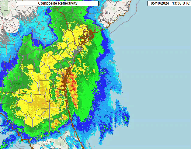
A very potent squall line moved across the NWS Jacksonville Forecast Area on Friday morning May 10, 2024. This system produced many severe weather reports across a good portion of the forecast area. The squall line moved very fast to east at around 60 mph, producing a wide swath of wind damage from Suwannee and Hamilton counties eastward to the Jacksonville Metro area. Luckily, no reports of tornadoes were received, but significant winds were realized based on surface reports and an NWS Storm Survey. The storm survey revealed damage up to near 80-100 mph over Suwannee county that caused many downed trees, either uprooted or snapped.. What did prove to be a challenge for radar warning operations for more detailed radar analysis was that Moody Radar (KVAX) was down and had been down since April 24th. Furthermore, the 88D Tallahassee Radar went down around 11 UTC when the squall line was passed over the radar site. |
 |
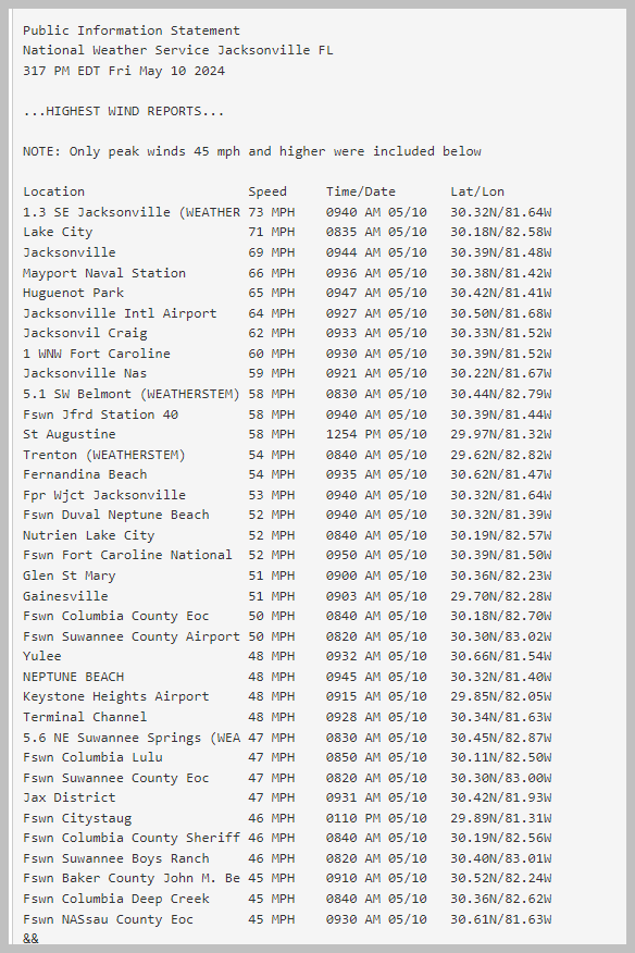
Wind Reports:
Watches and Warnings
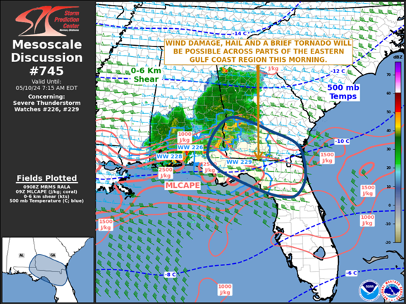
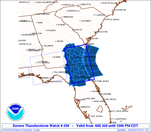
The Storm Prediction Center (SPC) issued Mesoscale Discussion #745 at 5:11 AM EDT on May 10th, identifying a “severe” Mesoscale Convective System (MCS) that was traversing the Florida panhandle, southeast Alabama, and southwest Georgia, which was within an existing Severe Thunderstorm Watch (#229) through 6 AM EDT. This Mesoscale Discussion identified a wind damage, hail and isolated tornado threat with this east-southeastward moving MCS, and the SPC stated that a new weather watch “may become necessary” as the severe MCS approaches the eastern edge of Severe Thunderstorm Watch #229. Severe Thunderstorm Watch #230 was issued at 6:05 AM EDT for the entire area of responsibility (AOR) for the National Weather Service (NWS) in Jacksonville, which includes 29 counties in southeast Georgia, northeast and north central Florida, including the Atlantic coastal waters out to 60 Nautical Miles offshore. Severe Thunderstorm Watch #230 was in effect until Noon EDT. The primary threats indicated from the “fast-moving and well-organized squall line” moving east-southeastward included “widespread damaging wind gusts…with isolated significant gusts to 80 mph possible”, “isolated large hail events to 1.5 inches in diameter possible”, along with “a tornado or two possible”.
The initial Severe Thunderstorm Warning issued by the NWS Jacksonville occurred at 7:03 AM EDT for portions of inland southeast Georgia to the west of Waycross, or for locations that were about to be impacted by the northern end of the lengthy MCS that extended southwestward across the Florida Big Bend region. The NWS Jacksonville briefly assumed warning responsibility for NWS Tallahassee around this time frame, as NWS Tallahassee sheltered for a Tornado Warning issued for Leon County, Florida. This Severe Thunderstorm Warning for inland portions of southeast Georgia was extended eastward at 7:43 AM EDT, as the northern end of the MCS moved rapidly eastward around 45 mph. The southwestward-extending MCS approached the Suwannee River shortly thereafter, prompting NWS Jacksonville to issue a Severe Thunderstorm Warning for the Suwannee Valley of north Florida and inland southeast Georgia at 7:50 AM EDT. This warning included a “Considerable” wind damage threat for the counties included, with the primary hazards being 70 mph wind gusts and quarter sized hail, in addition to a possible tornado. Impacts from this rapidly moving severe thunderstorm squall line (eastward at 55 mph) for the Suwannee Valley included “considerable tree damage” in addition to wind damage being “likely” for mobile homes, roofs, and outbuildings, in addition to hail damage to vehicles.
The Storm Prediction Center issued Mesoscale Discussion #746 at 8:17 AM EDT for Severe Thunderstorm Watches #229 and #230 as the “well developed MCS over southeast Georgia and northern Florida” continued moving rapidly east-southeastward across our region. In this Mesoscale Discussion, the SPC stated that the “…large scale bowing line segment may remain organized” and that “Wind damage will be possible along the leading edge of the more intense line segments.” Severe Thunderstorm Warnings (were extended eastward as this MCS accelerated its forward speed to 60 mph, with the “Considerable” wind damage threat for gusts up to 70 mph being maintained from the prior warning. An additional severe thunderstorm warning for inland southeast Georgia, or for locations north of the Okefenokee Swamp that were being impacted by the northern end of the MCS, was issued at 8:17 AM EDT.
Following a 71 mph wind gust report from the Airport Weather Observing Station (AWOS) at Lake City Regional Airport (KLCQ) at 8:35 AM EDT, a downstream Severe Thunderstorm Warning (#113) for much of northeast Florida and eastern portions of the Okefenokee Swamp in southeast Georgia that was issued at 8:44 AM that included a “Destructive” Wind threat of wind gusts up to 80 mph within the rapidly moving squall line, which had accelerated to a 70 mph forward speed. Additional Severe Thunderstorm Warnings (#114 and #117) were extended along the northern end of the MCS for coastal southeast Georgia through 9:45 AM EDT. Meanwhile, the bowing MCS and a well-developed Mesoscale Convective Vortex (MCV) continued its rapid eastward progression towards the Interstate 95 and U.S. Highway 301 corridors, prompting another Severe Thunderstorm Warning (#115) that carried a “Considerable” wind damage threat for wind gusts up to 70 mph that was issued at 9 AM EDT. The MCS finally showed signs of gradual weakening as it progressed towards the Atlantic coast, with downstream Severe Thunderstorm Warnings (#116 and #118) issued through the 10 AM EDT hour indicating the potential for damaging wind gusts up to 60 mph. The NWS Jacksonville discontinued Severe Thunderstorm Watch #230 for all land areas at 10:15 AM EDT as the MCS moved offshore, with the Watch remaining in effect for the adjacent Atlantic near shore and offshore waters until a final cancellation at 11:09 AM EDT.
A “Wake Low” event followed the passage of the MCS and MCV persisted behind the convective line for a couple of hours.

Photos
 |
 |
 |
 |
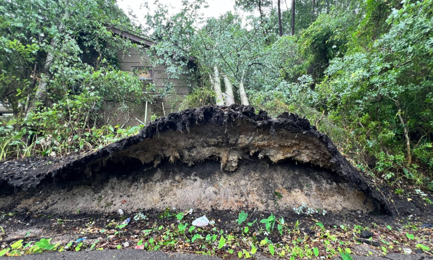
| Uprooted tree-Dunmire Ave (News4jax) |
Semi knocked over on the Dames Point Bridge (Duval co) (FDOT cam) |
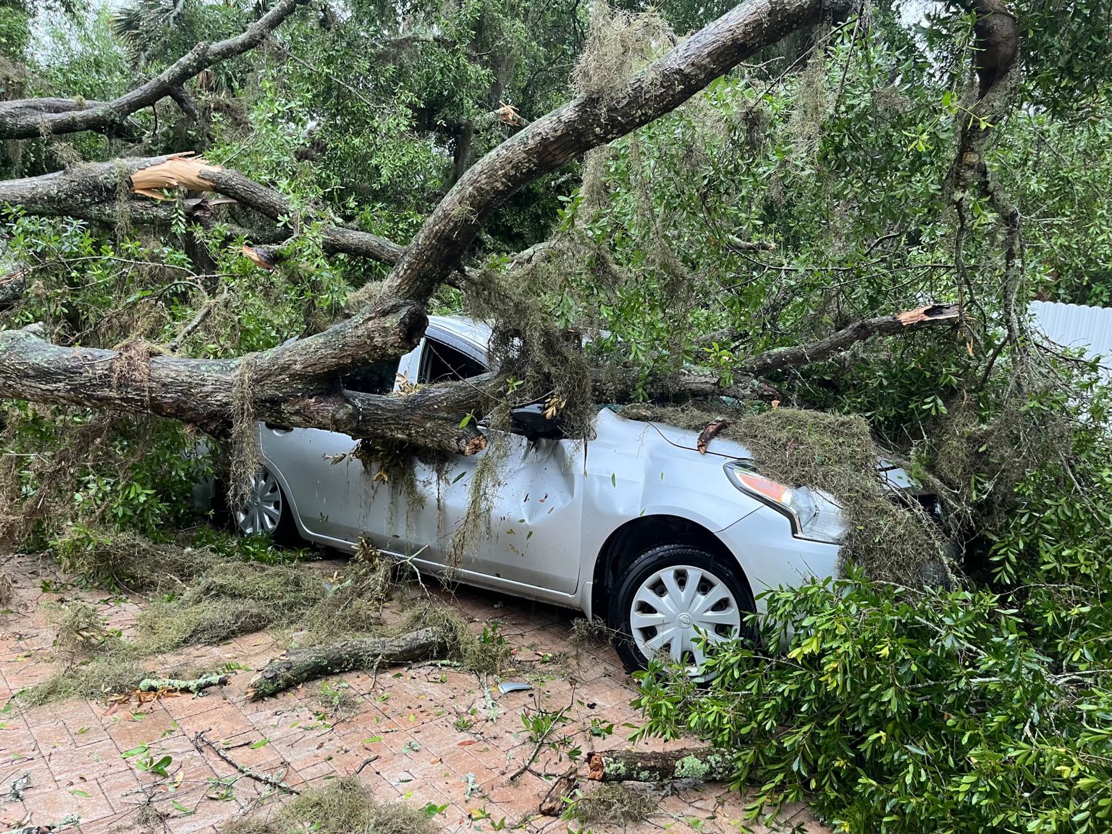
Tree crushed car, NW JAX |
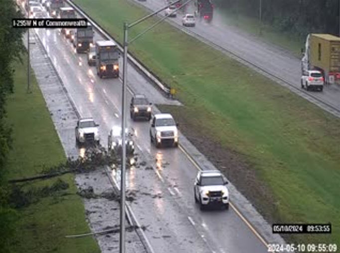
Large tree branches down on I-295 (FDOT cam) |
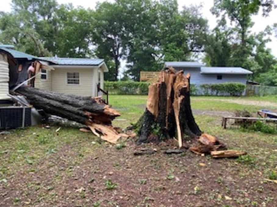
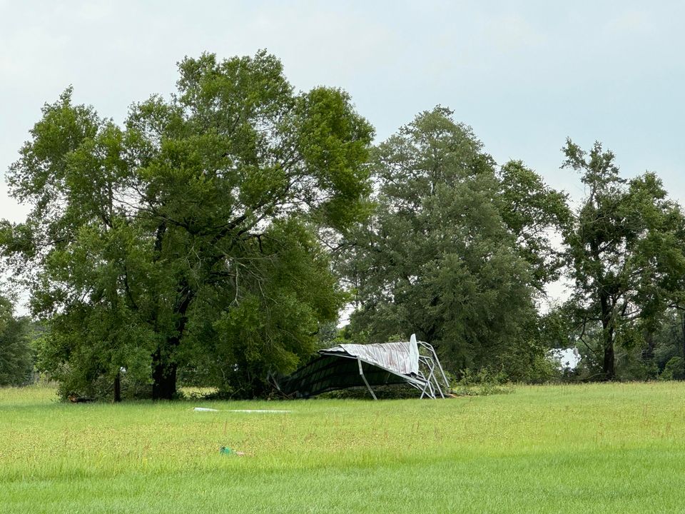
Tree fell on mobile home, Lake City FL Structure destroyed (Baker co)
(EMA) (EMA)
Environment
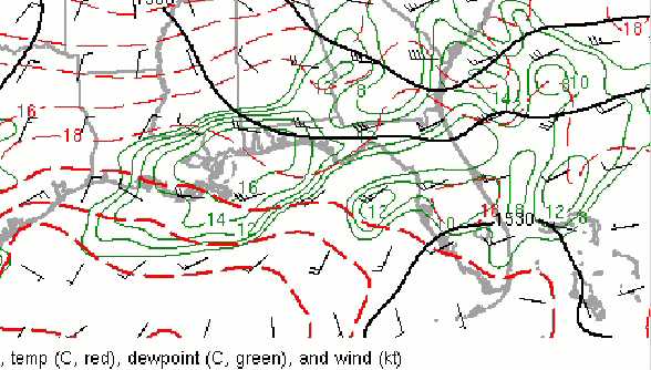
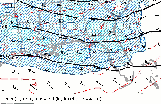
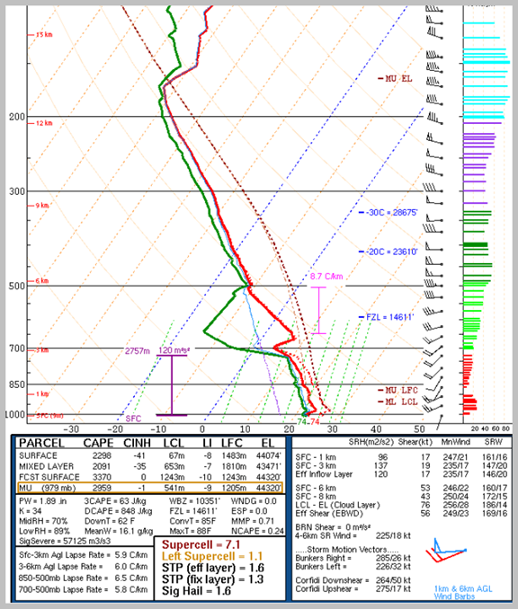
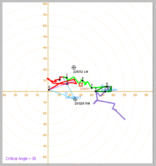
The surface map at Friday morning showed a cold front still well west of the WFO JAX forecast area across north central GA and central AL, with the squall line analyzed by the Weather Prediction Center at 7 AM over far southeast GA to north FL. Ahead of the front, the airmass was plenty moist with dewpoints in the upper 60s, lower 70s, and a few instances of mid 70s. MLCAPE of around 1500-2000 J/kg was noted and effective bulk shear values of 45-55 kt was analyzed. The 850 mb analysis (Fig 1) showed winds of up to 35-50 knots from the west southwest, 500 mb (Fig. 2) showed a shortwave disturbance moving through the region. The 300 mb wind field (Fig 3) indicated moderate to strong areas of upper-level divergence during the period of the squall line moving across the area that slowly weakened with time. Analysis of 0-3km CAPE showed values of about 30 to 65 J/kg. The 12Z JAX sounding (Fig 4) showed deep moisture through at around 725 mb, but low-level shear (Fig. 5) at first glance was not too conducive for tornado formation, except perhaps embedded within the squall line. It was noted that 0-1 km shear vector was around 20-30 knots per SPC mesoanalysis. Environmental 0-1km SRH was on the order 50-100 m2/s2, so relatively low end of the scale. Interestingly, a JAX ACARS sounding, which may be mostly derived from model data (Fig. 6), about 2 hours after the observed 12z JAX sounding, suggested weaker 0-6 km and 0-1 km shear of 30 knots and 17 knots, respectively. This data tends to contradict the SPC mesoanalysis showing weaker values so there is lower confidence in the validity of this data.
As far as the reasoning for a weaker reflectivity signature later on the squall line lifecycle, a few things are hypothesized for this outcome. First, there was still a fairly strong subsidence inversion at 700 mb per JAX 12z sounding. Second, the low-level part of the hodograph shows backing in the winds suggesting subsidence ahead of the line. And third, the radar presentation would seem to suggest the line becoming more outflow-dominant, as opposed to an upright convective line. The latter reasoning may also explain why we did not see much of any tornado signature, despite instability and low-level shear.
 |
 |
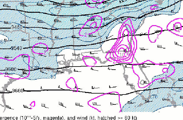 |
| Figure 1: 850 mb wind, temps | Figure 2: 500 mb wind, temps | Figure 3: 300 mb wind, temps |
Sounding Information:
 |
 |
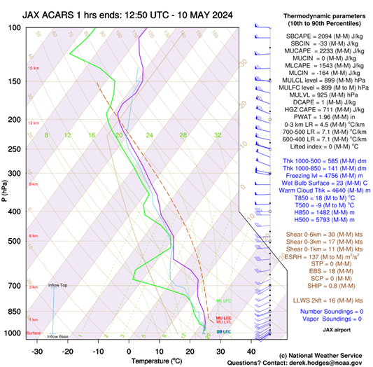 |
| Figure 4: JAX Skewt | Figure 5: JAX hodograph | Figure 6: ACARS sounding |
 |
Media use of NWS Web News Stories is encouraged! Please acknowledge the NWS as the source of any news information accessed from this site. |
|

