Overview
|
A potent winter squall line pushed across southeast Georgia and northeast Florida on the morning of November 30, 2020. This system produced severe wind damage reports across northeast Florida, most notably near Gainesville, FL and White Springs, FL as well as heavy rainfall across the entire forecast area and a brief tornado to our western neighbors near Madison, FL. |
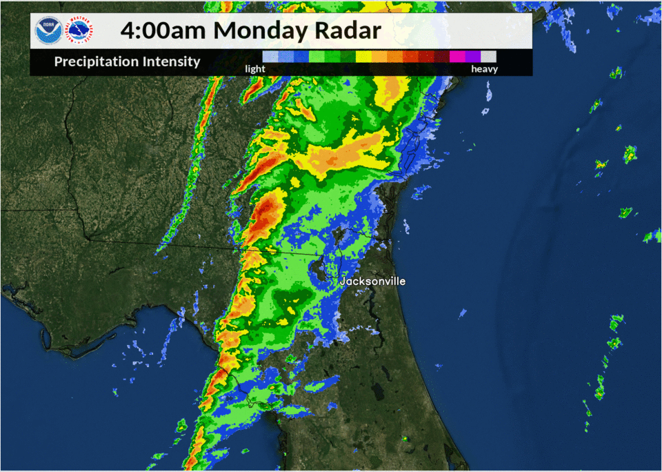 Squall Line Animation (MRMS Composite Reflectivity Nov 30th) |
Photos & Video
Facebook Live Video of Wind Damage in the Springtree Neighborhood of Gainesville, FL courtesy of CBS4 News.
Storm Reports
PRELIMINARY LOCAL STORM REPORT...SUMMARY
NATIONAL WEATHER SERVICE JACKSONVILLE FL
814 PM EST MON NOV 30 2020

..TIME...   ...EVENT...      ...CITY LOCATION...     ...LAT.LON...
..DATE...   ....MAG....      ..COUNTY LOCATION..ST.. ...SOURCE....
            ..REMARKS..

0430 AM     TSTM WND DMG     1 N WHITE SPRINGS       30.35N 82.76W
11/30/2020                   HAMILTON           FL   LAW ENFORCEMENT

            TREE REPORTED DOWN NORTH OF WHITE SPRINGS.
            TIMING OF EVENT APPROXIMATED VIA RADAR.

0510 AM     TSTM WND DMG     2 NW GAINESVILLE        29.70N 82.36W
11/30/2020                   ALACHUA            FL   BROADCAST MEDIA

            A LARGE TREE WAS BLOWN DOWN AND BLOCKED A
            WALKING PATH AND FELL ON FENCES NEAR THE
            INTERSECTION OF NW 45TH AVE AND NW 25TH AVE.
            THE TIME OF DAMAGE WAS BASED ON RADAR.

0511 AM     TSTM WND DMG     2 WNW GAINESVILLE       29.69N 82.37W
11/30/2020                   ALACHUA            FL   BROADCAST MEDIA

            MULITPLE TREES WERE BLOWN DOWN AND/OR
            SNAPPED IN THE SPRINGTREE SUBDIVISION. MANY
            HOMES SUFFERED DAMAGE DUE TO DOWNED TREES
            AND TREE LIMBS. THE TIME OF DAMAGE WAS BASED
            ON RADAR.

0512 AM     TSTM WND DMG     2 ENE GAINESVILLE       29.69N 82.30W
11/30/2020                   ALACHUA            FL   911 CALL CENTER

            TREES WERE BLOWN DOWN AND BLOCKING ROADS
            ALONG AND NEAR NW 39TH AVENUE IN
            GAINESVILLE. THERE WAS A HEAVY
            CONCERNTRATION OF TREES DOWN NEAR THE 2700
            BLOCK OF NW 39TH STREET. THE TIME OF DAMAGE
            WAS BASED ON RADAR.
Rain Reports
PUBLIC INFORMATION STATEMENT
NATIONAL WEATHER SERVICE JACKSONVILLE FL
817 PM EST MON NOV 30 2020

...PRECIPITATION TOTALS OVER 0.5 INCHES LAST 24 HOURS...

LOCATION                     AMOUNT    TIME/DATE       LAT/LON
GAINESVILLE                  1.08 IN   0811 PM 11/30   29.66N/82.33W
BLACKSHEAR                   0.98 IN   0810 PM 11/30   31.24N/82.29W
WAYCROSS                     0.96 IN   0804 PM 11/30   31.25N/82.40W
JACKSONVILLE                 0.69 IN   0813 PM 11/30   30.11N/81.52W
GAINESVILLE                  0.68 IN   0810 PM 11/30   29.67N/82.39W
GAINESVILLE 8.1 SW           0.63 IN   0830 AM 11/30   29.59N/82.43W
ALAPAHA TOWER                0.60 IN   0700 PM 11/30   30.53N/83.04W
3.0 NE ORANGE HEIGHTS        0.59 IN   0700 PM 11/30   29.75N/82.10W
UNIVERSITY OF FLORIDA        0.57 IN   0805 PM 11/30   29.64N/82.36W
2 WSW UNIVERSITY OF FLORIDA  0.56 IN   0810 PM 11/30   29.64N/82.39W
GAINESVILLE                  0.51 IN   0801 PM 11/30   29.66N/82.32W
GAINESVILLE                  0.51 IN   0753 PM 11/30   29.70N/82.28W

OBSERVATIONS ARE COLLECTED FROM A VARIETY OF SOURCES WITH VARYING
EQUIPMENT AND EXPOSURES. WE THANK ALL VOLUNTEER WEATHER OBSERVERS
FOR THEIR DEDICATION. NOT ALL DATA LISTED ARE CONSIDERED OFFICIAL.
Environment
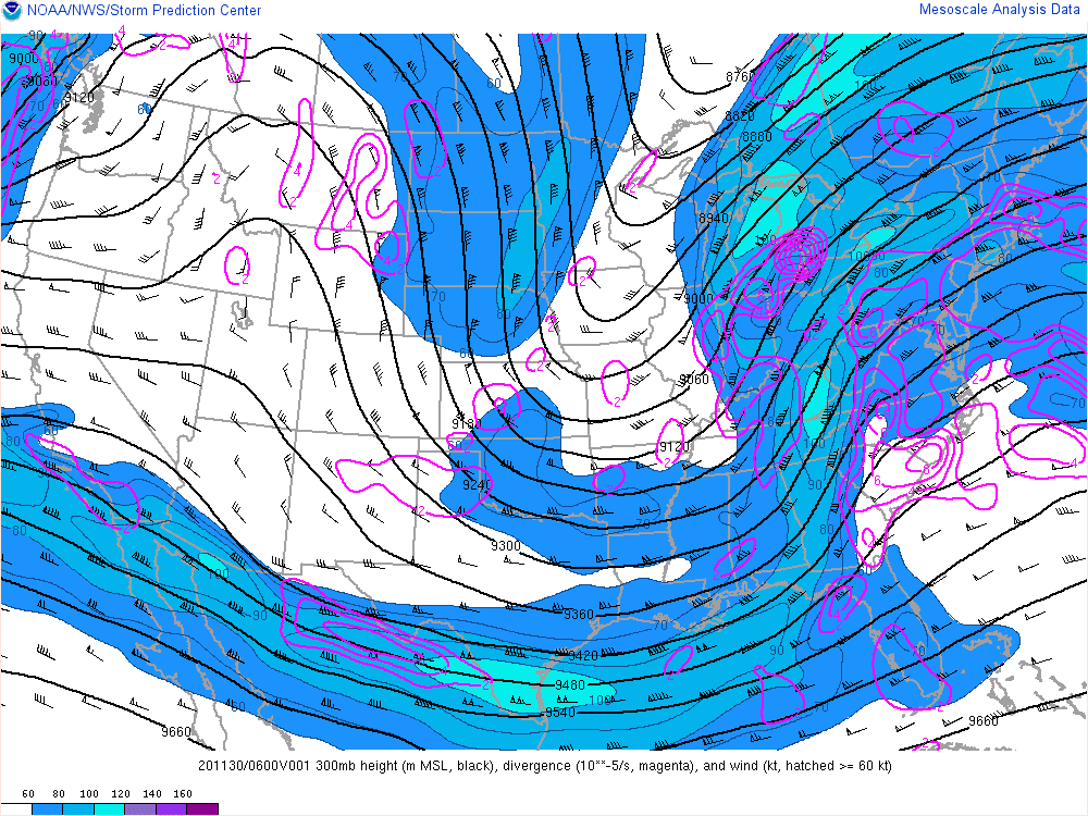
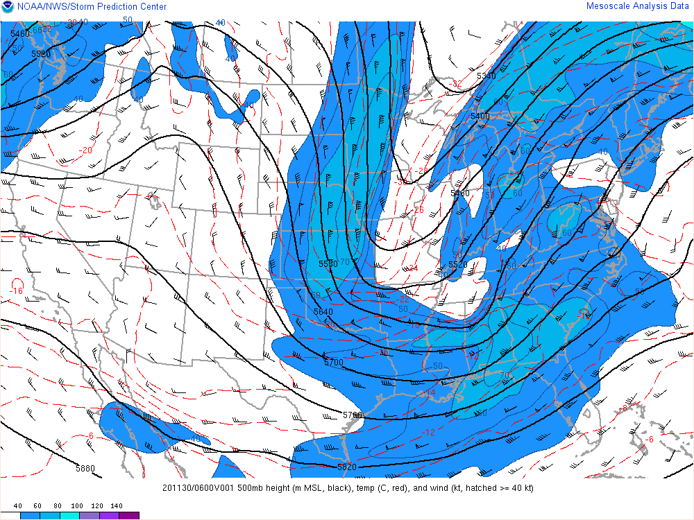
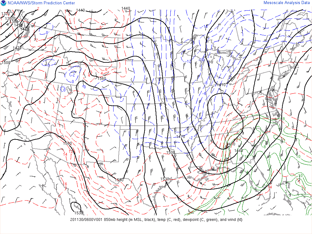
At 06Z (1 AM EST) on November 30, 2020, a broad upper level trough was in place aloft of the eastern two-thirds of the CONUS, with a positively tilted trough axis extending from the eastern edge of the Ontario Province of Canada southwestward into the southern Plains. Enhanced upper level divergence was analyzed aloft of eastern Georgia and in the Florida Big Bend. The 500 mb long wave trough pattern was very similar to the 300 mb trough axis, but also showed a shortwave trough ejecting into north Alabama. The 500 mb jet was draped across the southeast, with winds of 80-100 kts aloft of south Georgia and the Florida Panhandle and Big Bend. At 850 mb, there were 2 cut-off lows, one over the Great Lakes and one over the Tennessee Valley. A tongue of high dew points extended across the states of Florida and Georgia and eastward into the Carolinas. At the surface, 2 low pressure systems with corresponding warm and cold fronts were analyzed, the southernmost one being the one impacting our area of responsibility on the morning of 11/30/2020. The surface low of this closest system was near on the northern end of the Alabama/Georgia state line, with a warm front extending eastward to the South Carolina/Georgia border and a cold front extending southward down the Alabama/Georgia state line and the Apalachicola River in Florida. This place our local area in the warm sector of the front, the most favorable region for severe weather development.
 |
 |
 |
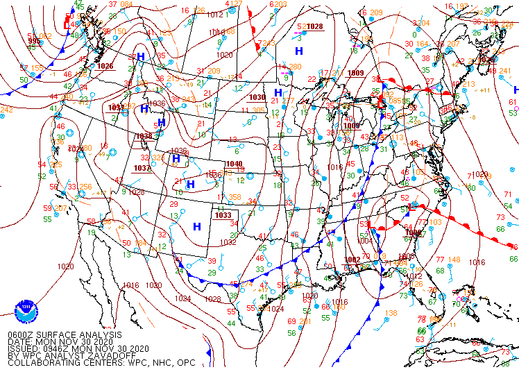 |
| 300mb analysis from 11/30/2020 at 06Z | 500mb analysis from 11/30/2020 at 06Z | 850mb analysis from 11/30/2020 at 06Z | Surface analysis from 11/30/2020 at 06Z |
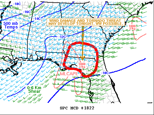
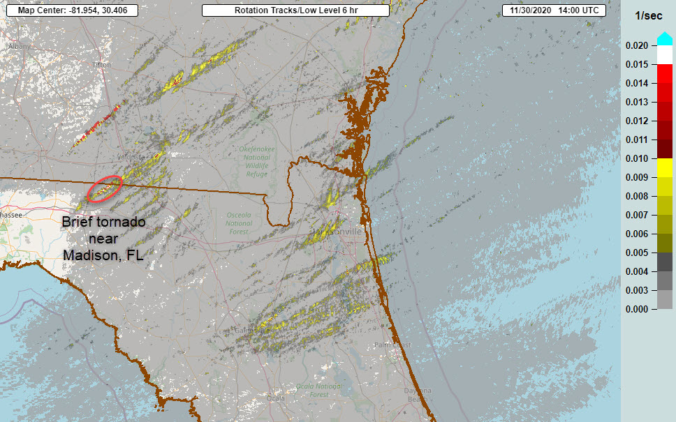
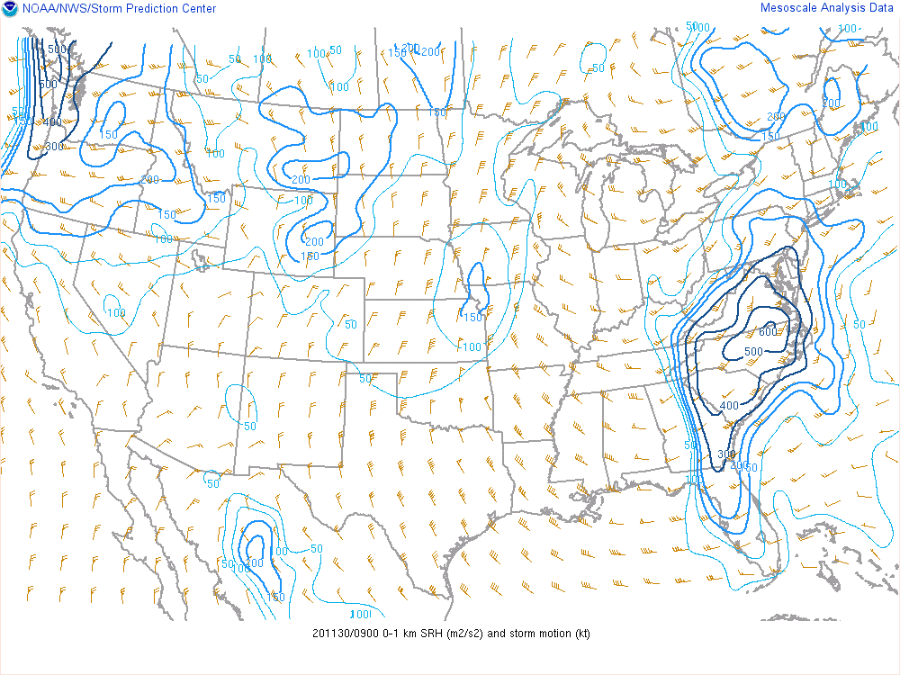
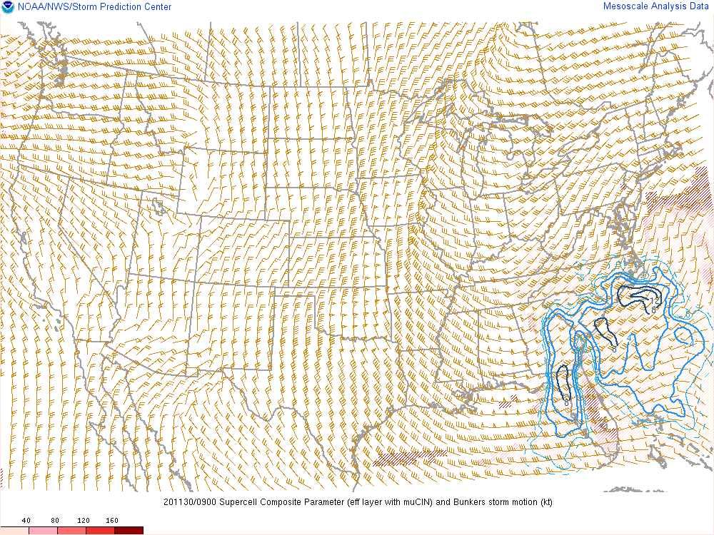
Shortly after 06Z, the Storm Prediction Center (SPC) issued mesoscale discussion #1822 prior to issuing a tornado watch. Their discussion highlighted the potential for damaging winds and tornadoes. The discussion noted MLCAPE of 100-1200 J/kg in south-central Georgia and the Florida Big Bend, along with 0-6 km shear values near 60 kts and 0-3 km Storm Relative Helicity (SRH) near 400 m2/s2. Around 08 Z (3 AM EST) a brief tornado touched down in Madison County, FL. The Multi-Radar Multi-Sensor (MRMS) low level rotation track from this storm is circled in red in the graphic below. By 09 Z (4 AM EST), as the storms were entering our area, the RAP mesoscale analysis showed the effective bulk shear to still be over 50 kts in northeast Florida, with 200-300 m2/s2 of 0-1 km SRH (and similar 0-3 km SRH values), and Supercell Composite Parameter (SCP) values over 8 in portions of northeast Florida, indicating the continued potential for both damaging winds and tornadoes as storms continued to move through the region.
The KJAX 12Z sounding (which is launched at 6 AM EST) showed 0-6 km shear of 65 kts, 0-1 km shear of 48 kts, and 800 mb winds around 55 kts, indicating that the severe threat would continue through the remaining morning hours as storms continued to sweep eastward. Fortunately, no tornadoes touched down in our area, however, the storms did produce very strong winds, causing tree damage in Gainesville, FL, particularly in the Springtree neighborhood, along with tree damage near White Springs, FL. These storms also produced heavy rainfall.
 |
 |
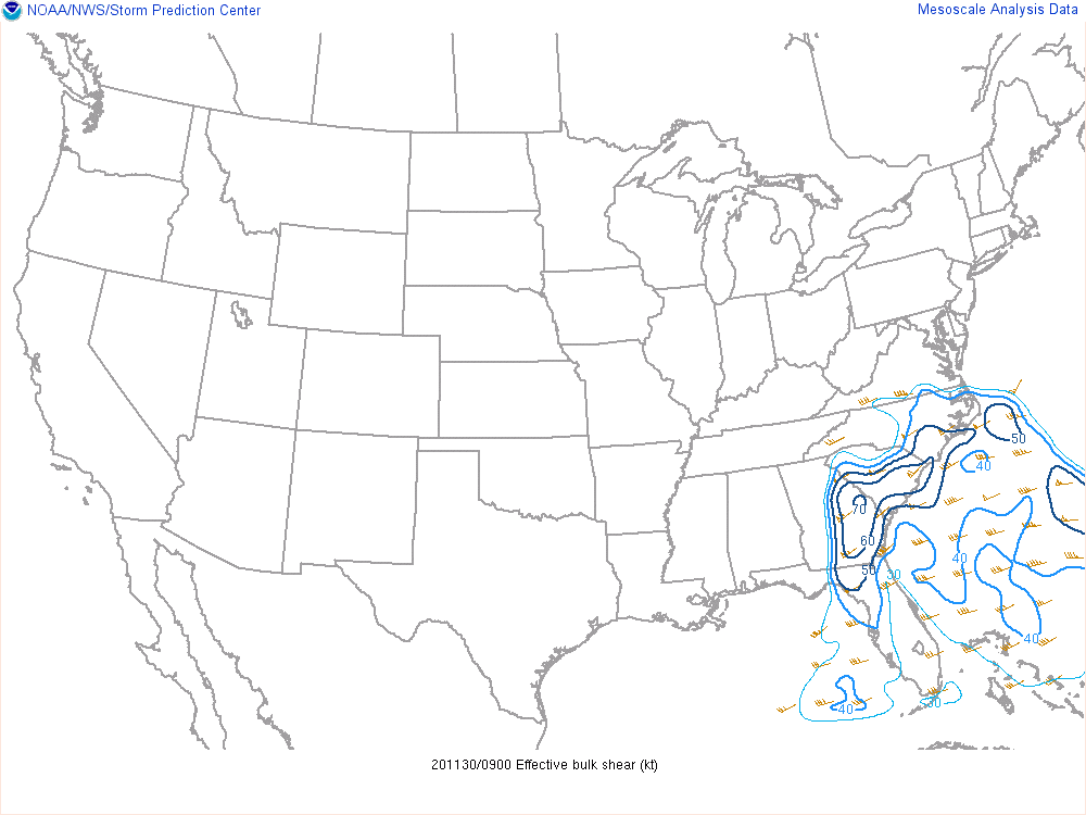 |
| Mesoscale Discussion #1822 from SPC shortly after 06Z on 11/30/2020 preceding a tornado watch. | MRMS low level rotation tracks over the 6 hour period of 08-14Z on 11/30/2020. | Effective bulk shear at 09Z on 11/30/2020 |
 |
 |
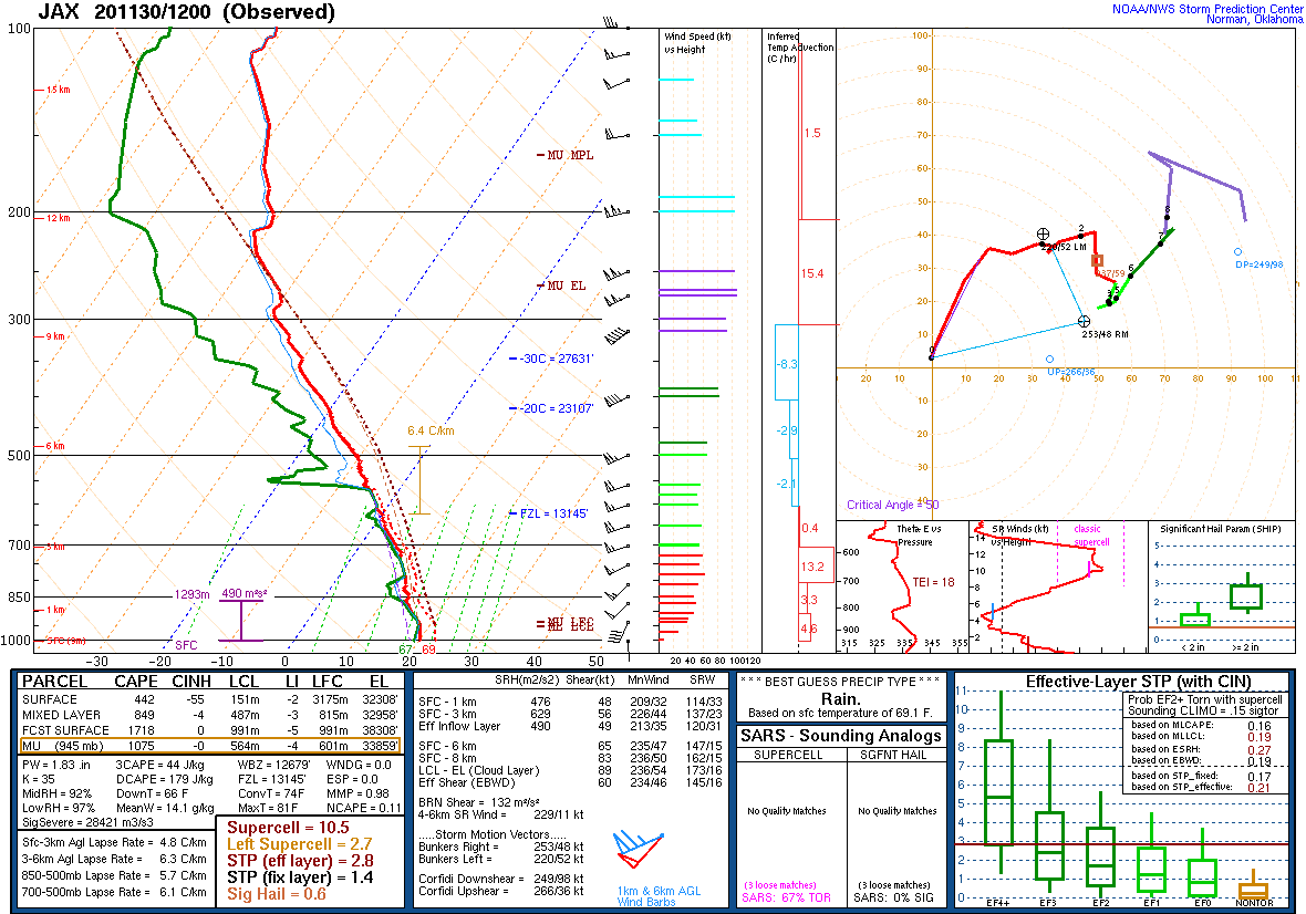 |
| 0-1 km Storm Relative Helicity (SRH) at 09Z on 11/30/2020 | Supercell Composite Parameter at 09Z on 11/30/2020 | KJAX sounding at 12Z on 11/30/2020 |
 |
Media use of NWS Web News Stories is encouraged! Please acknowledge the NWS as the source of any news information accessed from this site. |
|

