
Tropical Storm Bertha could bring tropical storm conditions to portions of the Florida Panhandle and Alabama coast through Wednesday, where a Tropical Storm Watch and Storm Surge Watch is in effect. Numerous severe thunderstorms with heavy rainfall are expected from the Ohio Valley into the Mid-Atlantic and Northeast Tuesday. Read More >
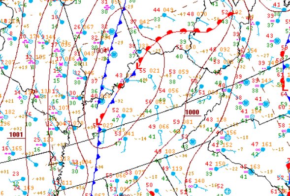
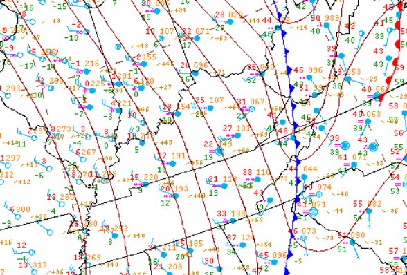
An arctic cold front barreled across eastern Kentucky late Sunday January 5th ushering in what would be the coldest temperatures and wind chills experienced in 20 years. Temperatures on Sunday afternoon warmed to near 60ºF in many locations, but by the next afternoon the mercury was 50 to 60 degrees colder, dropping through the single digits.
 |
 |
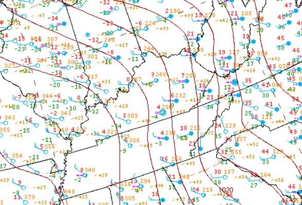 |
| 4 pm EST Sunday January 5th | 1 am EST Monday January 6th | 10 am EST Monday January 6th |
Rain falling in advance of the arctic front quickly changed over to snow, and there was even a few rumbles of thunder observed as the arctic air poured into eastern Kentucky. Most folks woke up to an inch or two of new snow on Monday morning, with temperatures in the single digits and teens, with a few spots seeing up to three inches. The highest snow totals occurred on top of Black Mountain where four to five inches was observed on Highway 160 at the Kentucky/Virginia state line.
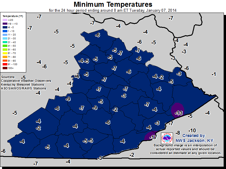
The big story was the cold. Temperatures by Tuesday morning January 7th ranged from 2 below zero to 9 below zero in the valleys of eastern Kentucky, down to 17 below zero at the top of Black Mountain. Gusty west to northwest winds combined with these temperatures to produce wind chills in the 15 to 30 below range for most locations, with the highest terrain along the Virginia border dropping even lower.
 |
 |
...LOWEST OBSERVED WIND CHILLS...

LOCATION                       TEMP      TIME/DATE
BLACK MOUNTAIN SUMMIT(MESONET) -40*      0355 AM 01/07
13 S PIKEVILLE (MESONET)       -36       0345 AM 01/07
3 SSE WHITESBURG (ROAD)        -29       0420 AM 01/07
5 N HINDMAN (MESONET)          -27       0330 AM 01/07
3 N FARMERS (ROAD) (933 FT)    -27       0310 AM 01/07
TRIANGLE MTN (RAWS) (1359 FT)  -25       0102 AM 01/07
4 S OWINGSVILLE (MESONET)      -25       1230 AM 01/07
2 N SOMERSET (SCHOOL)          -25       1144 PM 01/06
MOUNT STERLING APT             -24       0135 AM 01/07
2 SW WEST LIBERTY (MESONET)    -24       0145 AM 01/07
1 WSW MT VERNON (SCHOOL)       -24       1209 AM 01/07
4 NE MOREHEAD (MESONET)        -23       1230 AM 01/07
LONDON-CORBIN APT (1188 FT)    -23       1253 AM 01/07
1 E BOONEVILLE (MESONET)       -22       0109 AM 01/07
KOOMER RIDGE (RAWS) (1299 FT)  -22       0109 AM 01/07
NWS JACKSON (1388 FT)          -22       0153 AM 01/07
2 NW LONDON (ROAD) (1214 FT)   -21       1240 AM 01/07
SOMERSET (RAWS) (920 FT)       -21       1101 PM 01/06
5 S MCKEE (MESONET) (1319 FT)  -20       0145 AM 01/07
JACKSON APT (RAWS) (1388 FT)   -20       0315 AM 01/07
BIG SANDY APT (RAWS) (1180 FT) -20       0409 AM 01/07
5 WNW IRVINE (PUBLIC) (850 FT) -19       1225 AM 01/07
2 SW MT. STERLING (PUBLIC)     -19       0932 PM 01/06
PINE RIDGE (PUBLIC) (1295 FT)  -19       1229 AM 01/07
3 SE BARBOURVILLE (MESONET)    -19       0115 AM 01/07
1 NW BURNSIDE (ROAD) (870 FT)  -19       1120 PM 01/06
3 N WHITLEY CITY (MESONET)     -18       0230 AM 01/07
1 WNW KOOMER RDG (ROAD)        -18       0255 AM 01/07
2 S BOONEVILLE (MESONET)       -17       0200 AM 01/07
PEABODY (RAWS) (1464 FT)       -16       0501 AM 01/07
3 SE JACKSON (MESONET)         -15       0315 AM 01/07
2 NW WHITESBURG (MESONET)      -15       0400 AM 01/07
YELLOW CREEK (RAWS) (1089 FT)  -14       0226 AM 01/07
4 W PAINTSVILLE (MESONET)      -14       0400 AM 01/07
MIDDLESBORO APT                -14       0315 AM 01/07

* WIND CHILL VALUES FOR THE BLACK MOUNTAIN MESONET STATION WERE
 DERIVED FROM TEMPERATURE AND WIND SPEED DATA THAT HAS NOT BEEN
 QUALITY CONTROLLED.
The last time there were widespread below zero temperatures in eastern Kentucky was in the middle 1990s. An examination of historical records shows that major cold waves occurred more frequently from the late 1800s until the mid 1990s, with the recent long stretch without a major cold air outbreak being very unusual.
The following table shows the low temperatures observed the morning of January 7, 2014 for locations with records that date back at least 30 years.
| Station | Observed Minimum January 7, 2014 | Date last time temperatures were this cold or colder | All time record minimum temperature | Year records began |
| Jackson | -7 | -8, February 4, 1996 | -18 on 1/19/1994, 1/21/1985, 1/20/1985 | 1981 |
| London | -4 | -25 January 19, 1994 | -25 on 1/19/1994 | 1954 |
| Williamsburg | -3 | -16, February 6, 1996 | -21 on 1/20/1994, 1/19/1994 | 1892 |
| Farmers | -5 | -13, February 5, 1996 | -28 on 1/28/1963 | 1904 |
| Mount Sterling | -5 | -5, December 16, 2010 | -22 on 2/10/1899 | 1892 but with several gaps |
| Somerset | -4 | -4, January 22, 1994 | -36 on 1/18/1994 | 1950 |

