Criteria may be adjusted in certain circumstances to take into account the expected impact of an event. For example, a Winter Weather Advisory may be issued for less than an inch of snow if it will occur at a peak travel time, such as around the normal morning commute time, and thus potentially have a significant impact.
|
Severe Thunderstorm or Tornado Watch
- Severe thunderstorms and/or tornadoes are possible, but the exact time and location of storm development is still uncertain.
Severe Thunderstorm Warning
- Radar or satellite indicate and/or reliable reports of thunderstorms with:
- Wind gusts equal to in excess of 58 mph
- AND/OR hail size of 1 inch (U.S quarter size) in diameter or larger.
Tornado Warning
- Radar indication and/or reliable reports of tornado or developing tornado.
Special Weather Statement
- Strong thunderstorms that approach, or expected to approach severe criteria.
- A strong thunderstorm contains one or combination of the following events:
- Wind gusts of 40 to 57 mph
- Hail less than 1 inch in diameter
- Frequent to continuous lightning
- Landspouts that are not anticipated to threaten lives and/or property
- Funnel clouds not expected to become a tornado threat
See NWSI 10-511 WFO Severe Weather Products Specification for additional information.
|
|
Flood Watch
- Approximately 50 to 80 percent chance of meteorological, soil, and/or hydrologic conditions leading to river and/or flash flooding, typically within 48 hours.
Flash Flood Watch
- Flash Flooding threat caused by rare situations such as dam or levee failure, ice jams, flash flooding or debris flows induced by excessive rainfall on burn scars possible, but not imminent.
Flash Flood Warning
- Life or property-threatening, short-term rapid onset flooding is imminent or occurring. This can include flooding due to heavy rainfall or due to a dam or levee break.
Flood Warning
- Flooding due to potentially damaging river level rises,
- OR damaging overland flooding that is expected to persist for many hours.
Flood Advisory
- Nuisance flooding due to river level rises and minor overland flooding and/or ponding of water that warrants notification of the public but less urgent than a warning.
Special Weather Statement
- Heavy rainfall that is expected to cause hazardous travel conditions but is not expected to cause flooding.
See NWSI 10-922 WFO Hydrologic Products Specification for additional information.
|
|
Winter Storm Watch
- Conditions are favorable (typically at least 50 percent chance) for a winter weather event having one or more hazards (i.e., snow, snow and blowing snow, snow and ice, snow and sleet, snow, ice and sleet, or freezing rain) to meet or exceed Winter Storm, Blizzard, or Ice Storm Warning criteria.
Blizzard Warning
- Sustained wind or frequent gusts greater than or equal to 35 mph accompanied by falling
- AND/OR blowing snow, frequently reducing visibility to less than ¼ mile for 3 hours or more.
Ice Storm Warning
- Ice accumulation of ¼" or more on an elevated horizontal flat surface.
Snow Squall Warning
- Heavy snow and gusty winds reducing visibility to ¼ mile or less with sub-freezing ambient road surfaces
- AND/OR plunging temperatures behind an arctic front sufficient to produce flash freezes, along with a significant reduction in visibility from falling and/or blowing snow
- AND at least a risk for a flash freeze.
Winter Storm Warning
- Heavy snow accumulation of 4" or more within 48 hours or less
- AND/OR sleet accumulation of ½" or more
- AND/OR mixed precipitation with at least one winter hazard type (blizzard, freezing rain, sleet, or snow) meeting or exceeding warning criteria
- OR high impact frozen precipitation outside of the normal winter season or during a critical situation (standard criteria not being met, but impacts are expected to be unusually significant).
Winter Weather Advisory
- Snow accumulations of between 1 and 4", or impacts expected with 1" or less of snow
- AND/OR Freezing rain accretions less than ¼" on an elevated horizontal flat surface
- AND/OR Sleet accumulation less than ½"
- AND/OR Black ice causing widespread slick roads and/or numerous accidents
- AND/OR Blowing snow that reduces visibilities to ¼ mile or less.
Special Weather Statement
- Black ice,
- OR short-duration heavy snow bands below warning criteria.
See NWSI 10-513 WFO Winter Weather Products Specifications for additional information.
|
|
Extreme Cold Watch
- Conditions are favorable (typically at least 50 percent chance) for air temperatures or wind chill values to meet or exceed local Extreme Cold Warning criteria.
Extreme Heat Watch
- Conditions are favorable (typically at least 50 percent chance) for an extreme heat event to meet or exceed Extreme Heat Warning criteria in the next 24 to 72 hours.
Freeze Watch
- Conditions are favorable (typically at least 50 percent chance) for a freeze event to meet or exceed Freeze Warning criteria in the next 12 to 48 hours during the growing season.
High Wind Watch
- Conditions are favorable (typically at least 50 percent chance) for a high wind event to meet or exceed High Wind Warning criteria in the next 12 to 48 hours.
Blowing Dust Warning
- Widespread synoptically driven blowing dust reducing visibilities to ¼ mile or less
- AND winds of 25 mph or greater usually required
- AND generally for a duration of longer than 90 minutes.
Blowing Dust Advisory
- Widespread synoptically driven blowing dust reducing visibilities to 1 mile or less but greater than ¼ mile
- AND winds of 25 mph or greater usually required
- AND generally for a duration of longer than 90 minutes.
Dust Storm Warning
- Dust storm reducing visibility to ¼ mile or less, with sudden reduction in visibility
- AND winds of 25 mph or greater usually required
- AND typically localized and brief in duration.
Dust Advisory
- Dust reducing visibility to 1 mile or less but greater than ¼ mile, with sudden reduction in visibility
- AND winds of 25 mph or greater usually required
- AND typically localized and brief in duration.
Extreme Heat Warning
- Maximum heat index around 110ºF or higher
- AND the minimum heat index will remain around 75ºF or higher
- AND conditions persist for at least 48 hours;
- OR Heat Advisory criteria is to be met for at least 4 consecutive days.
Heat Advisory
- Maximum heat index of around 105ºF or higher for up to 3 consecutive days.
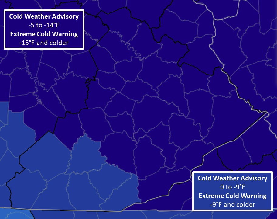
Extreme Cold Warning
- Air temperatures or wind chill values reaching or exceeding the county-level warning criteria (displayed below).
Cold Weather Advisory
- Air temperatures or wind chill values reaching or exceeding the county-level warning criteria (displayed below).
Freeze Warning
- Minimum shelter temperature is forecast to be 32°F or less during the growing season. The beginning and end of the growing season are determined in conjunction with the University of Kentucky Agricultural Weather Center.
Frost Advisory
- Minimum shelter temperature is forecast to be 33°F to 36°F during the growing season, on nights with good radiational cooling conditions (e.g., light winds and clear skies). The beginning and end of the growing season are determined in conjunction with the University of Kentucky Agricultural Weather Center.
High Wind Warning
- Sustained non-thunderstorm wind speeds of at least 40 mph for 1 hour or more
- OR non-thunderstorm wind gusts of 58 mph or greater for any duration.
Wind Advisory
- Sustained non-thunderstorm wind speeds of 30 and 39 mph for at least 1 hour
- OR non-thunderstorm wind gusts of 40 to 57 mph for any duration.
Lake Wind Advisory (for Lake Cumberland, Laurel Lake, and Cave Run Lake only)
- Sustained non-thunderstorm wind speeds of 20 to 29 mph for at least 1 hour
- OR non-thunderstorm wind gusts of 35 to 39 mph.
Dense Fog Advisory
- Widespread fog reducing visibility to ¼ mile or less
- OR localized fog reducing visibility to ¼ mile or less producing major impacts.
Dense Smoke Advisory
- Widespread smoke reducing visibility to ¼ mile or less
- OR localized smoke reducing visibility to ¼ mile or less producing major impacts.
Freezing Fog Advisory
- Freezing fog producing light ice accretion and slippery conditions.
Special Weather Statement
- Heat indices, wind chill or air temperature values near "advisory" level for an hour or two,
- OR local areas of dense fog, dense smoke or other hazards that are below advisory criteria.
See NWSI 10-515 WFO Non-Precipitation Weather Products Specification for additional information.
|
|
Fire Weather Watch
- High probability for weather and fuel conditions meeting or exceeding Red Flag Warning criteria commencing in 18 to 96 hours.
Red Flag Warning
- Sustained 20-foot wind speeds of 15 mph or greater
- AND minimum relative humidity of 25% or less
- AND 10-hour fuel moisture values of 8% or less.
Special Weather Statement
- Low confidence or borderline red flag conditions:
- Critically low relative humidity values
- Near criteria wind gusts
- Marginal 10-hour fuel moistures
See NWSI 10-401 Fire Weather Services Product Specification for additional information.
|


