Overview
|
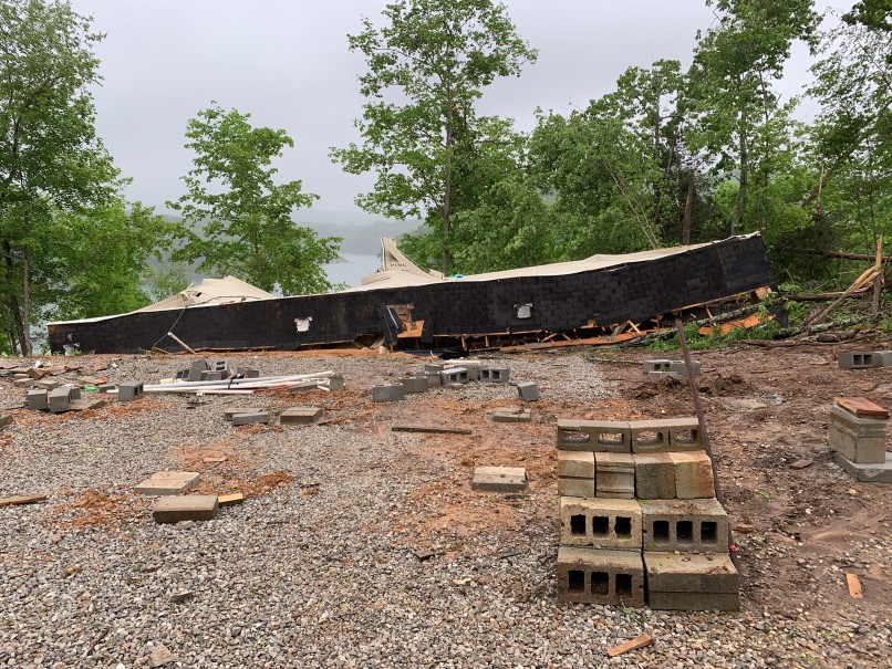
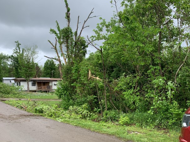
A potent late spring upper low drifted directly toward eastern Kentucky on May 6th. The system's warm front, cold front, and several surface troughs spread multiple episodes of showers and storms across the area from the early morning hours until late in the evening. Rainfall totals on the order of 1 to 5 inches were reported at many locations south of I-64 corridor with the heaviest swath falling from Martin, Johnson, and eastern Morgan counties southward to Bell, Whitley, and McCreary counties. Sporadic bullseyes of heavy rainfall also occurred west of I-75 and in Estill and Fleming counties. This led to areal flooding, in most cases minor and/or urban, and multiple mudslides. The excess runoff eventually flowed into area rivers and caused minor river flooding in portions of the Kentucky River basin and atypically high water in the upper Licking. Aside from the rainfall, several marginally strong to severe thunderstorms crossed eastern Kentucky during the afternoon producing mainly minor wind damage. However, a better organized storm briefly dropped an EF-1 tornado in the Burnside area where it damaged multiple structures and downed trees. Two people were injured in a mobile home that was flipped off its foundation by the tornado. |
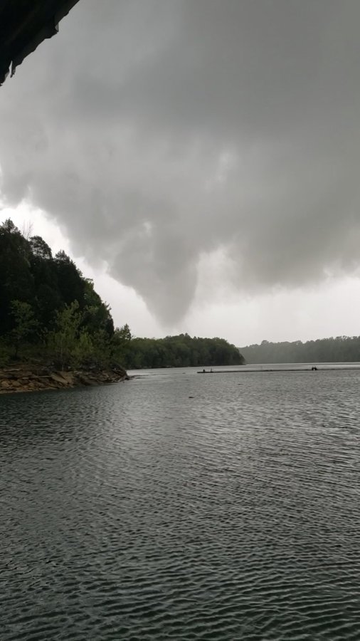 View of Tornado Funnel near Burnside Island (Courtesy of Michael Baker ) |
Tornadoes:
|
Tornado - Burnside
Track Map 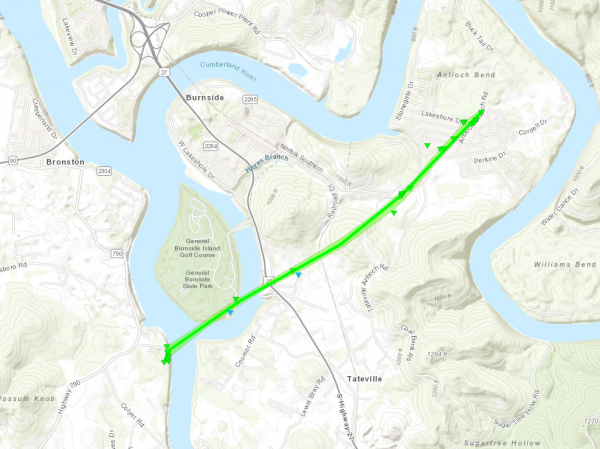 
|
||||||||||||||||
The Enhanced Fujita (EF) Scale classifies tornadoes into the following categories:
| EF0 Weak 65-85 mph |
EF1 Moderate 86-110 mph |
EF2 Significant 111-135 mph |
EF3 Severe 136-165 mph |
EF4 Extreme 166-200 mph |
EF5 Catastrophic 200+ mph |
 |
|||||
 |
 |
 |
 |
| Trailer Home Tipped off of Foundation Courtesy of NWS Storm Survey |
Destroyed Trailer Home Courtesy of NWS Storm Survey |
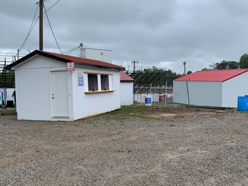
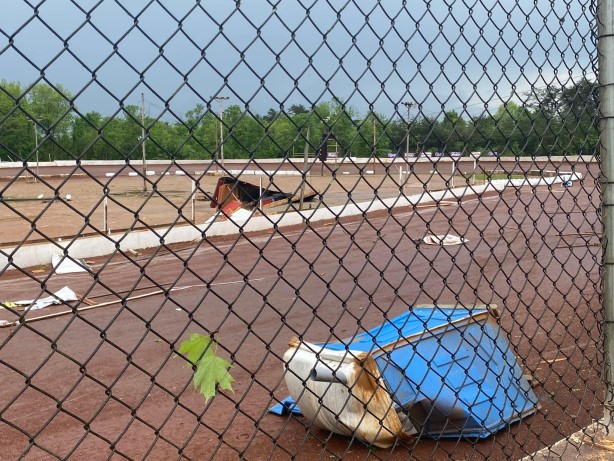
Displaced Booth at Lake Cumberland Speedway Courtesy of NWS Storm Survey |
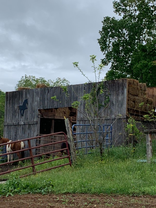
Roof Torn off of Hay Barn Courtesy of NWS Storm Survey |
 |
 |
 |
 |
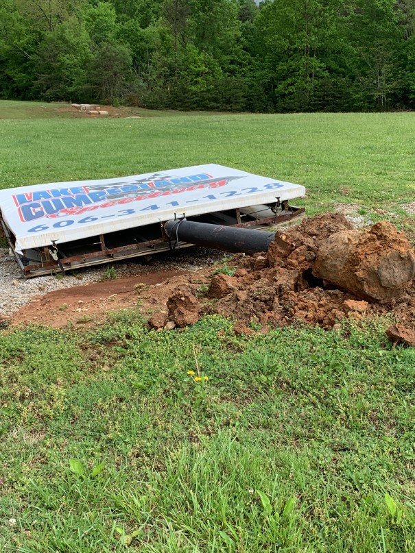
| Collapsed Lake Cumberland Speedway Sign Courtesy of NWS Storm Survey |
Wayward Porta-Potty at Lake Cumberland Speedway (Courtesy of Lake Cumberland Speedway) |
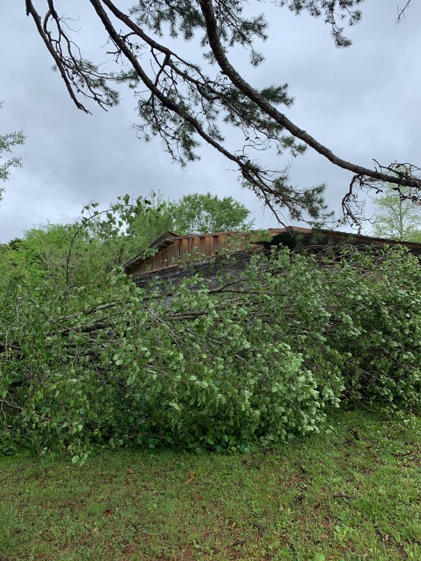
Tree and Structure Damage Courtesy of NWS Storm Survey |
Tree Damage Courtesy of NWS Storm Survey |
Flooding
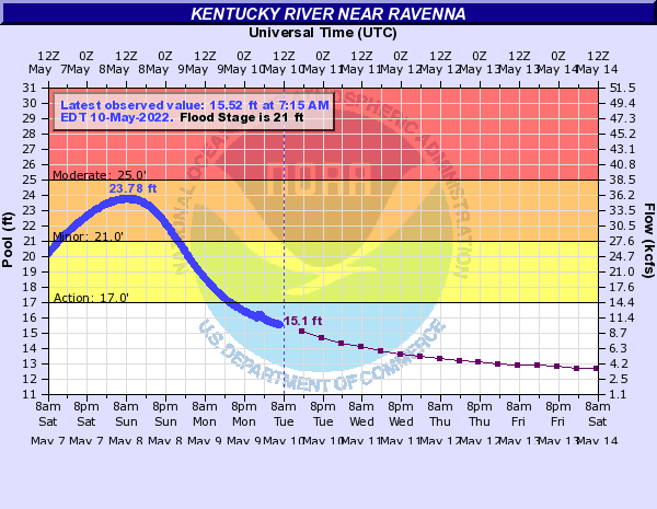
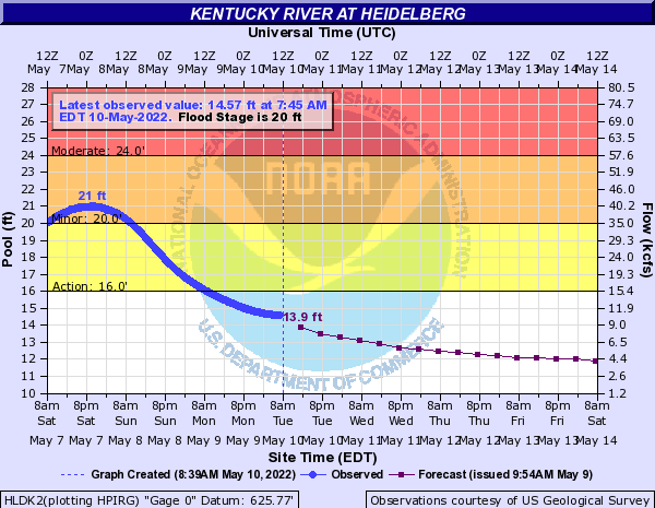
Several episodes of showers and thunderstorms put down multiple inches of rain at most locations south of the I-64 Corridor. Flash flooding was limited by rapid storm motions, but the cumulative impact of the rainfall episodes led to flooding at many locations. In fact, enough rain fell in the upper portions of the Kentucky River Basin to push the South Fork of the Kentucky at Booneville as well as the mainstem Kentucky River at Heidelburg and Ravenna into minor flood.
Hydrographs
 |
 |
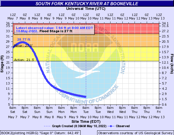 |
| Kentucky River at Ravenna | Kentucky River at Heidelberg | South Fork Kentucky River at Booneville |
Photos
 |
 |
 |
.jpg) |
 |
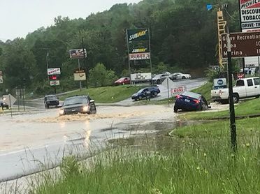
| Flooded Street in Corbin (Courtesy of Chris Bailey) |
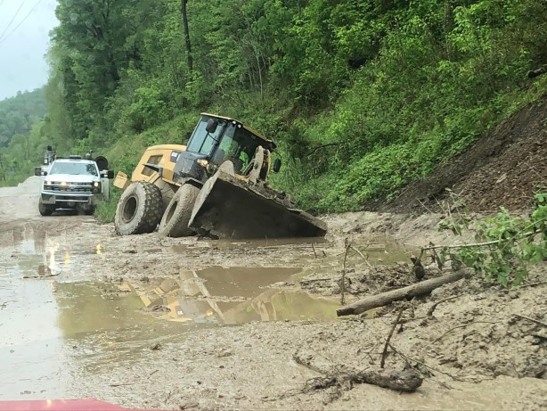
Mudslide along Highland Road, Breathitt County (Courtesy of Johnny Ray Feltner) |
Flooding along Belcher Fork, Breathitt County (Courtesy of Johnny Ray Feltner) |
Flooding along Abbott Creek Rd, Floyd County (Courtesy of Eric Thomas) |
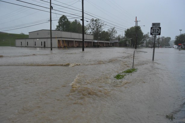
Street Flooding along KY-312 in Corbin (Courtesy of Johnny Ray Feltner) |
Radar
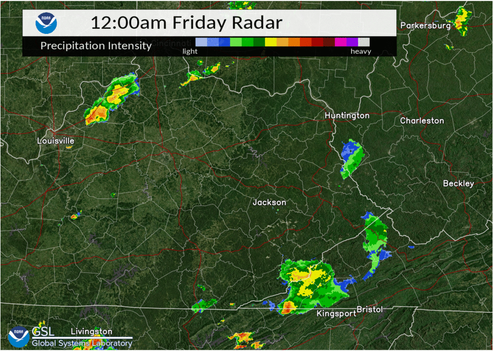 |
| Event Radar Loop (12 AM May 6th - 12 AM May 7th) |
Rain Reports
48-Hour Rainfall Amounts Ending Saturday Morning May 7th, 2022 (Sorted by County)

Location                     Amount    Time/Date       Lat/Lon

Bath County
4 S Owingsville              0.67 in   0800 AM 05/07   38.09N/83.76W

Bell County
1 SW Stony Fork              2.92 in   0830 AM 05/07   36.82N/83.54W
Middlesboro-Bell County AP   2.40 in   0800 AM 05/07   36.61N/83.74W
Yellow Creek RAWS            1.50 in   0800 AM 05/07   36.60N/83.70W

Breathitt County
3 SE Jackson                 3.88 in   0800 AM 05/07   37.54N/83.34W
14 SE Jackson                3.03 in   0930 AM 05/07   37.43N/83.18W
14 ESE Jackson               3.02 in   0930 AM 05/07   37.46N/83.16W
NWS Office/Julian Carrol AP  2.90 in   0800 AM 05/07   37.59N/83.32W
Jackson Airport RAWS         2.40 in   0800 AM 05/07   37.59N/83.32W
9 SE Campton                 2.38 in   0700 AM 05/07   37.66N/83.41W

Clay County
Peabody RAWS                 3.30 in   0800 AM 05/07   37.14N/83.58W
Oneida                       2.64 in   0900 AM 05/07   37.27N/83.65W

Elliott County
9 SSE Olive Hill             1.28 in   0900 AM 05/07   38.19N/83.08W

Estill County
Cressy                       2.06 in   0800 AM 05/07   37.83N/84.04W

Fleming County
2 ESE Ewing                  0.89 in   0700 AM 05/07   38.42N/83.83W

Floyd County
3 WSW Prestonsburg           2.46 in   0700 AM 05/07   37.66N/82.83W
Hueysville                   1.93 in   0700 AM 05/07   37.50N/82.84W
2 S Grethel                  1.65 in   0700 AM 05/07   37.47N/82.65W

Harlan County
5 NE Baxter                  2.49 in   0700 AM 05/07   36.90N/83.24W
3 N Harlan                   2.48 in   0755 AM 05/07   36.88N/83.31W
24 E Harlan                  1.88 in   0800 AM 05/07   36.92N/82.91W

Jackson County
5 S McKee                    2.35 in   0800 AM 05/07   37.36N/83.97W
8 W McKee                    1.55 in   0645 AM 05/07   37.43N/84.14W

Johnson County
1 E Paintsville              2.50 in   0700 AM 05/07   37.82N/82.79W
4 W Paintsville              2.35 in   0800 AM 05/07   37.83N/82.88W

Knott County
Carr Creek                   2.77 in   0700 AM 05/07   37.23N/83.03W
5 N Hindman                  2.05 in   0800 AM 05/07   37.41N/82.99W

Knox County
3 E Barbourville             2.44 in   0800 AM 05/07   36.87N/83.83W

Laurel County
London-Corbin Airport        2.18 in   0800 AM 05/07   37.09N/84.07W
4 S London                   2.04 in   0706 AM 05/07   37.07N/84.09W

Lee County
4 N Beattyville              2.30 in   0900 AM 05/07   37.63N/83.72W
9 WNW Beattyville            2.10 in   0700 AM 05/07   37.62N/83.86W

Letcher County
2 NW Whitesburg              1.89 in   0800 AM 05/07   37.13N/82.84W
2 SE Whitesburg              1.74 in   0700 AM 05/07   37.10N/82.80W
Skyline                      1.71 in   0700 AM 05/07   37.09N/82.99W

Martin County
5 WSW Pilgrim                2.58 in   0830 AM 05/07   37.76N/82.49W
2 E Inez                     2.32 in   0700 AM 05/07   37.87N/82.52W
Big Sandy RAWS               2.17 in   0800 AM 05/07   37.75N/82.64W

McCreary County
2 S Stearns                  3.64 in   0700 PM 05/07   36.67N/84.48W
1.5 S Stearns                3.64 in   0700 AM 05/07   36.67N/84.48W
3 N Whitley City             1.96 in   0800 AM 05/07   36.77N/84.48W

Montgomery County
5 N Mount Sterling           0.67 in   0700 AM 05/07   38.13N/83.96W
3 W Mount Sterling           0.63 in   0730 AM 05/07   38.07N/83.99W
Mount Sterling AP            0.49 in   0800 AM 05/07   38.06N/83.98W

Morgan County
14 ENE West Liberty          3.05 in   0900 AM 05/07   37.96N/83.02W
1 ENE West Liberty           1.41 in   0700 AM 05/07   37.92N/83.25W
2 SW West Liberty            1.34 in   0800 AM 05/07   37.90N/83.27W

Owsley County
4 ENE Booneville             2.11 in   0700 AM 05/07   37.50N/83.62W
2 S Booneville               1.93 in   0800 AM 05/07   37.45N/83.69W

Perry County
Buckhorn Lake                2.36 in   0700 AM 05/07   37.34N/83.47W
1 N Viper                    1.83 in   0631 AM 05/07   37.19N/83.15W

Pike County
13 S Pikeville               1.52 in   0800 AM 05/07   37.28N/82.51W

Powell County
1 WNW Clay City              1.78 in   0700 AM 05/07   37.87N/83.93W
2 W Stanton                  1.43 in   0800 AM 05/07   37.86N/83.90W

Pulaski County
Somerset RAWS                1.84 in   0800 AM 05/07   37.05N/84.61W
Somerset-Pulaski County AP   1.83 in   0800 AM 05/07   37.05N/84.61W
7 NNE Somerset               1.49 in   0800 AM 05/07   37.18N/84.56W
4 SSE Burnside               1.17 in   0700 AM 05/07   36.93N/84.58W

Rowan County
Triangle Mountain RAWS       1.11 in   0800 AM 05/07   38.18N/83.41W
8 ESE Morehead               1.06 in   0730 AM 05/07   38.14N/83.30W
4 NE Morehead                0.84 in   0800 AM 05/07   38.22N/83.48W
6 NE Morehead                0.76 in   0637 AM 05/07   38.24N/83.34W

Wayne County
4 NW Monticello              1.18 in   0930 AM 05/07   36.87N/84.90W

Whitley County
7 SW Corbin                  5.04 in   0700 AM 05/07   36.87N/84.21W

Wolfe County
Koomer Ridge RAWS            1.87 in   0800 AM 05/07   37.78N/83.63W
Observations are collected from a variety of sources with varying
equipment and exposures. We thank all volunteer weather observers
for their dedication. Not all data listed are considered official.
Environment
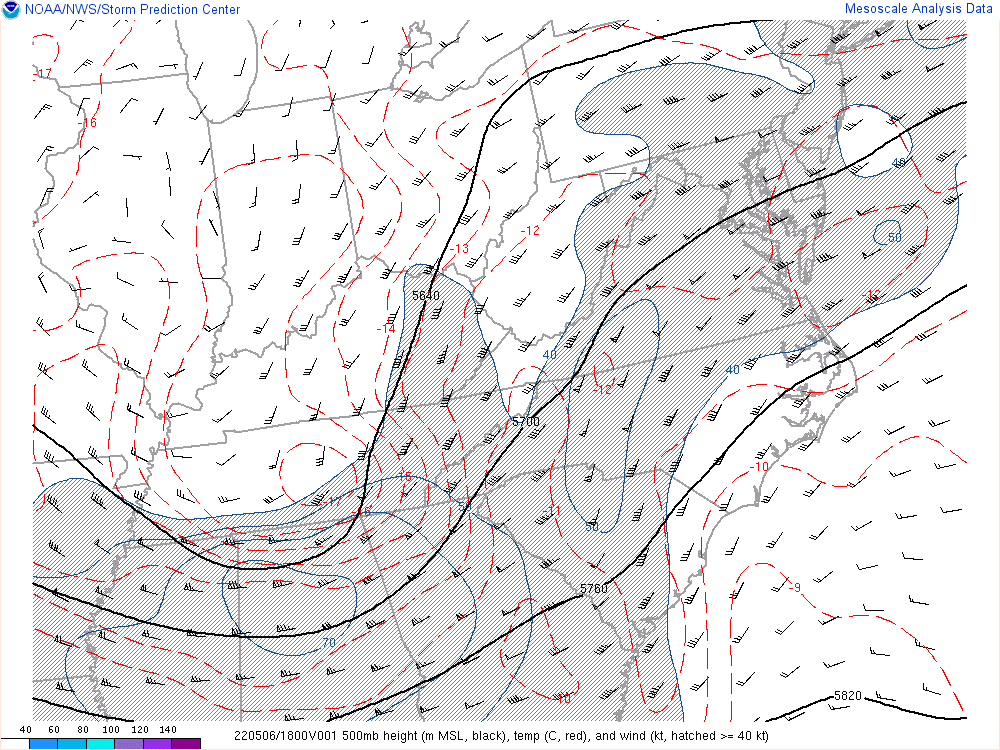
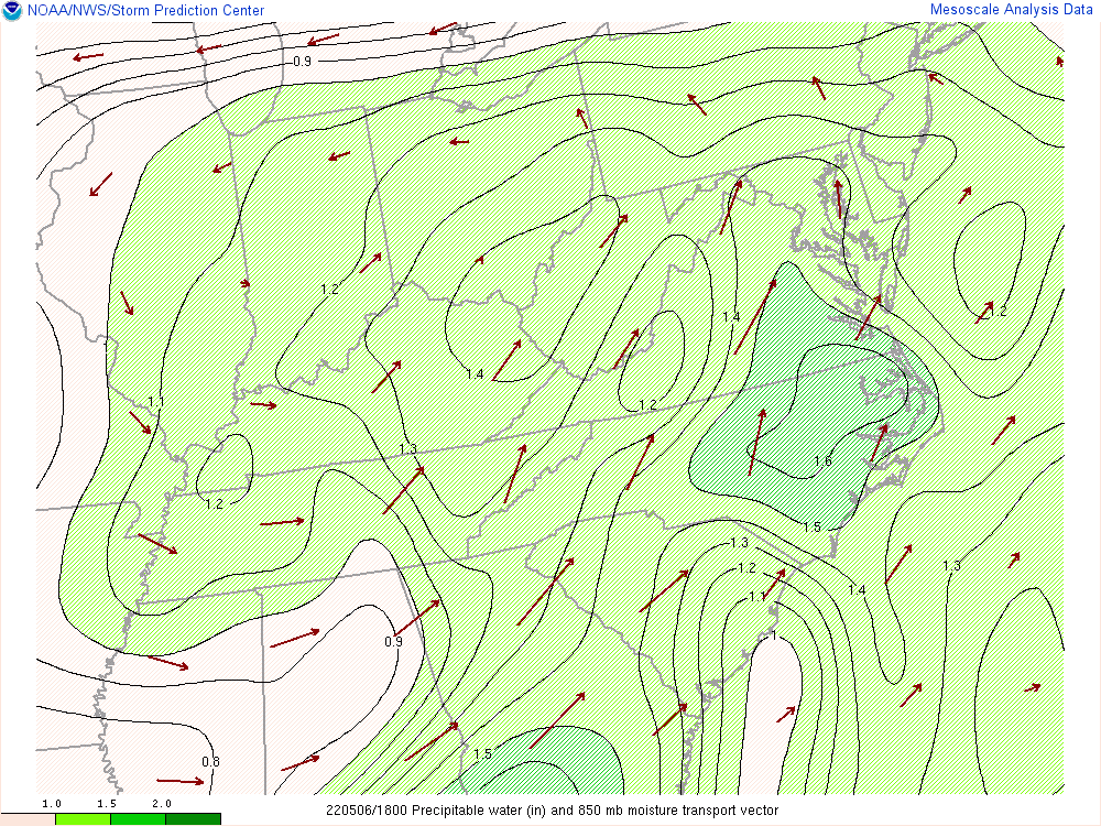
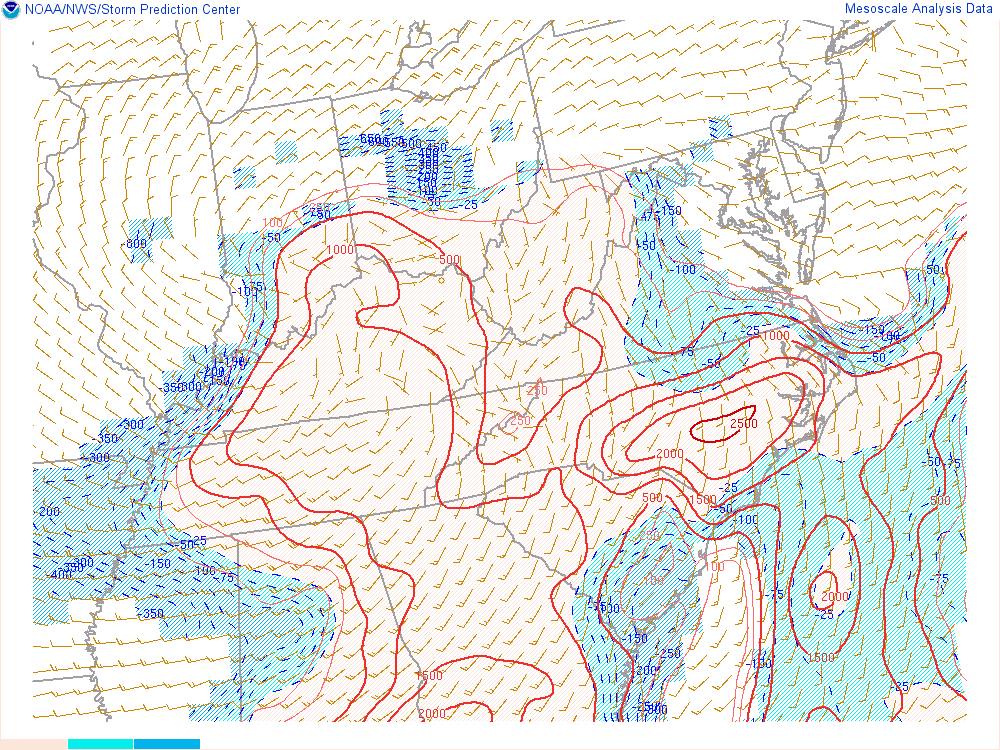
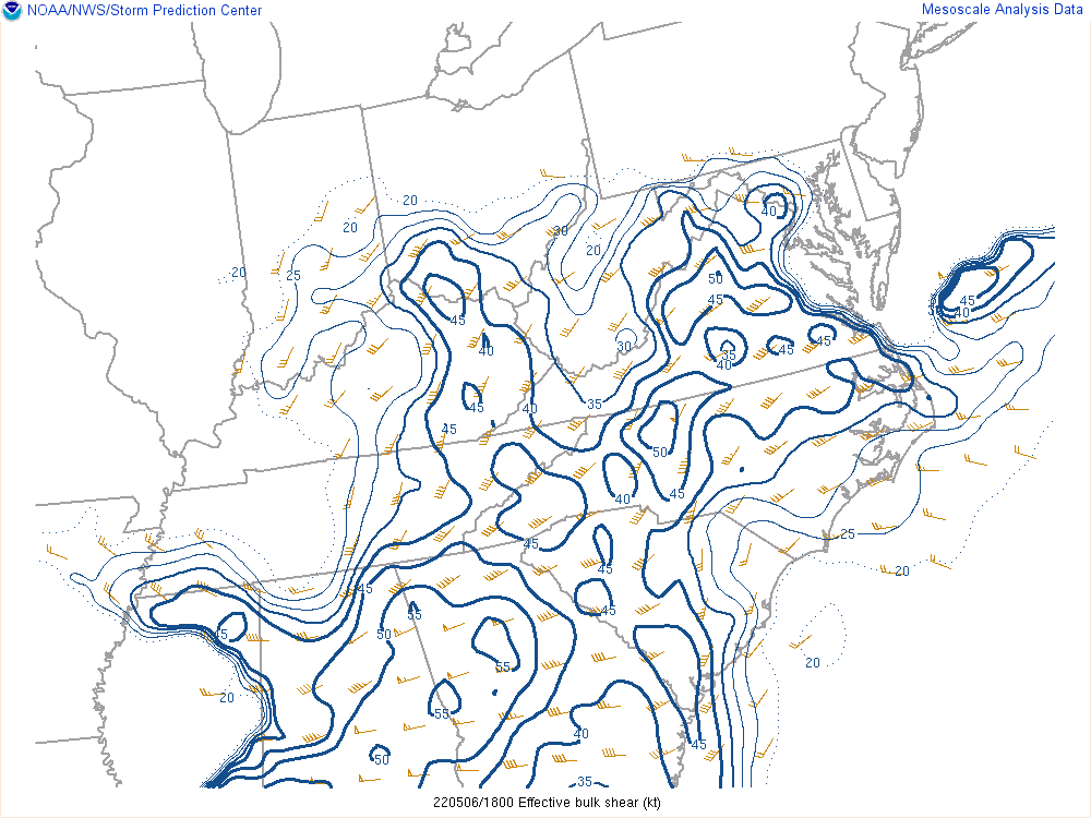
Deepening surface low pressure lifted from the Mid-Mississippi Valley to the Central Appalachians (Figure 1). The system's associated warm/cold fronts and multiple troughs triggered multiple rounds of showers and storms. At 500mb (Figure 2), a rather sharp trough aloft was shifting eastward into the Ohio Valley. Ahead of this trough, deep moisture, evidenced by PWATS (Figure 3) near/exceeding the 90th percentile relative to climatology and a mere 500 to 1000 J/kg of MLCAPE or instability (Figure 4), provided an environment favorable for relatively efficient rain processes. The weak instability and an uncapped environment led to a rather messy storm mode in spite of 40 to 45 knots of effective shear (Figure 5). Several stronger storm cells took on hybrid supercellular characteristics but struggled to organized further. The Burnside tornado occurred with one of these supercell hybrids even though the low-level kinematic mesoscale conditions were not that favorable for tornadogenesis. In fact, storm relative helicity values (Figure 6), which are related to the low-level veering of the winds, in the 0 to 1 km layer were barely 50 m^2/s^-2 or about half of what is typically observed threshold with tornadic supercells. Radar imagery (Figure 7) near the middle of the ongoing tornado showed slightly enhanced inbound Base and Storm Relative Velocities typical of weak supercells but nowhere near thresholds typically associated with tornadic cells. Nothing was particularly notable in the Correlation Coefficients or Base Reflectivity products.
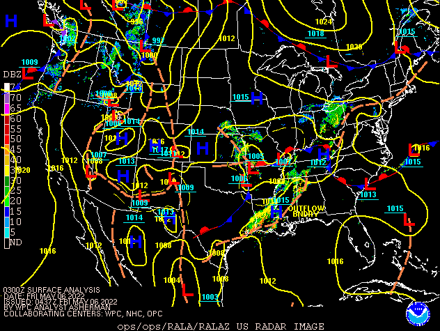 |
| Figure 1: Surface Analysis 11 PM May 5th - 2 AM May 7th |
Mesoanalysis Data from 2 PM (shortly after the Burnside Tornado) and Radar Data at 152 PM (during the Burnside Tornado).
 |
 |
 |
| Figure 2: 500 mb Level at 2 PM, May 6th | Figure 3: Precipitable Water at 2 PM, May 6th | Figure 4: ML CAPE at 2 PM, May 6th |
 |
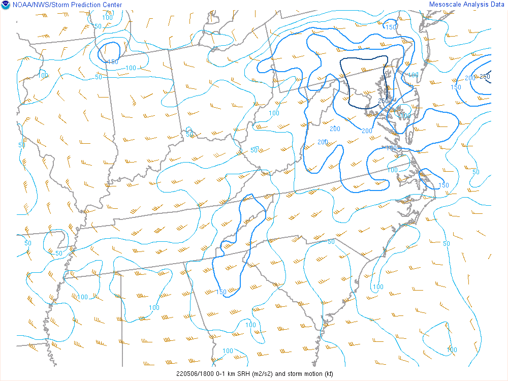 |
| Figure 5: Effective Shear at 2 PM, May 6th | Figure 6: 0-1 km Storm Relative Helicity at 2 PM, May 6th |
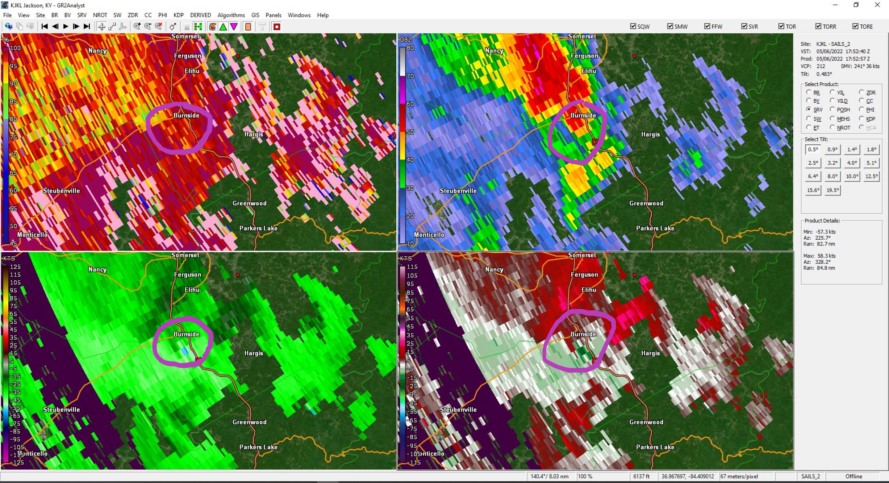 |
| Figure 7: 0.5 Degree Radar Data at 1:52 PM, Correlation Coefficient (upper left), Base Reflectivity (upper right), Base Velocity (lower left), Strom Relative Velocity (lower right) |
 |
Media use of NWS Web News Stories is encouraged! Please acknowledge the NWS as the source of any news information accessed from this site. |
|

