
Extreme heat continues today from the central Plains to the lower Mississippi River Valley, over southeast Montana, and from southern California into the Southwest Deserts. Extreme Heat Warnings remain in effect. Severe thunderstorms capable of strong to severe wind gusts and large hail are possible across the Great Lakes into the Ohio Valley today into tonight. Read More >
Overview
A strong upper level storm system and intense surface low pressure moved from the Southern Plains to the Mississippi Valley during the wee morning hours of Friday, March 3rd.The surface low pressure system rapidly deepened during the day on Friday as it passed just north of the Ohio River and broke long-standing minimum pressure records at multiple locations. At Paducah, which has records dating back to 1937, the sea level pressure bottomed out at 977.7 mb, well below the previous minimum pressure record of 981 mb set in 1960. At Evansville, which has records dating back to 1897, the sea level pressure bottomed out at 976.0 mb, once again well below the 979.7 mb record observed in 1926.
As this system approached, this system's warm front spread a band of showers northward across the area overnight of the 2nd into the morning of the 3rd. Winds increased across the higher elevations above 2,500 feet and in portions of Middle Tennessee and Central Kentucky toward dawn on Friday. In the system's warm sector, winds were breezy but still relatively tame, generally gusting 25 to 50 mph, strongest on southeastern ridges and near Lake Cumberland. Many locations saw sunshine buoying temperatures to near or above 70 degrees ahead of the system's cold front which approached from the west around midday, but dew points struggled to rise above 60 even in the Lake Cumberland area. Very minimal instability and intense shear proved prohibitive to sustained shower and and thunderstorm organization with the cold front.
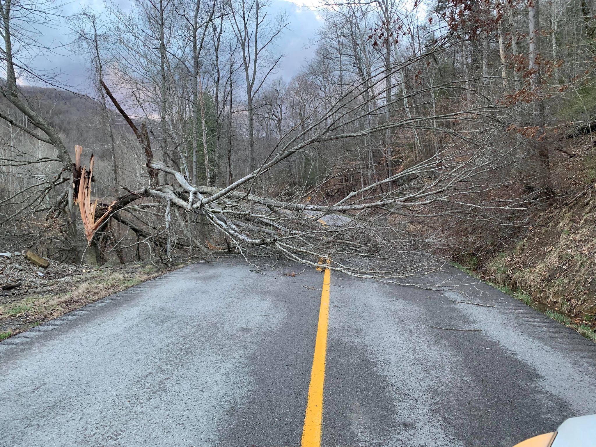
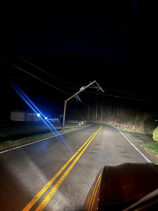
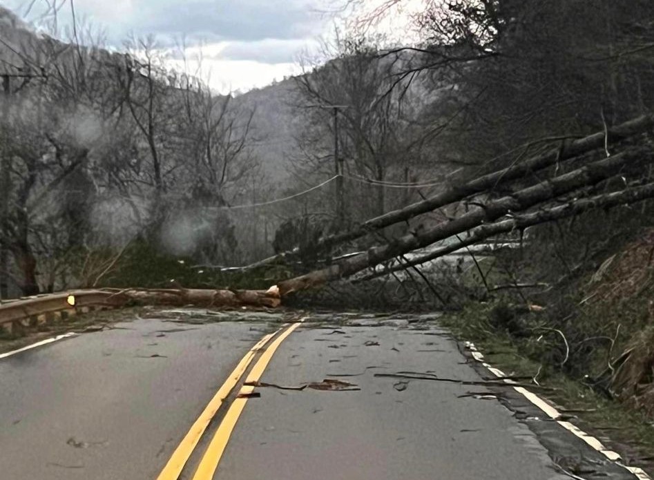
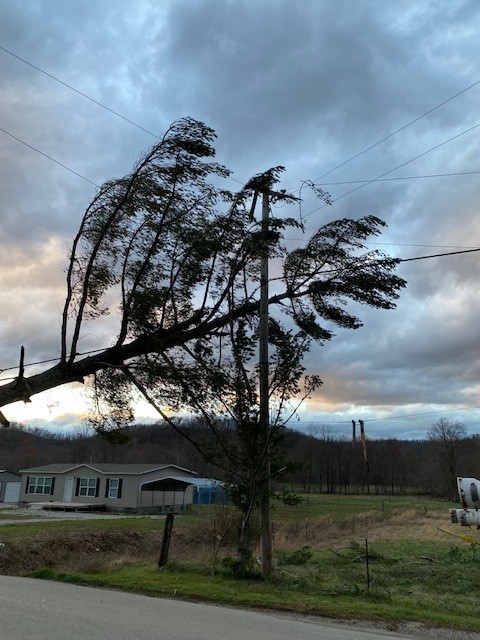
While the shallow showers and storms that formed failed to mix down most of the momentum within the storm system's extremely intense wind field, strong cold air advection in the low-levels resulted in an unstable low-level atmosphere behind the cold front. This allowed momentum from the intense winds just a few thousand feet above the ground to mix down and surface leading to a period of strong to damaging wind gusts, most concentrated between 5 PM and 10 PM over eastern Kentucky. Across the ridges and flatter terrain, wind gusts generally peaked between 50 and 70 mph. Winds were weaker in the more sheltered valleys and narrow hollows, peaking at 30 to 50 mph, still sufficient to bring down weaker limbs and trees. During the evening, the NWS Office at the Julian Carroll airport (KJKL) recorded multiple gusts to 58 mph or stronger, with a peak gust of 65 mph. This gust is the strongest measured gust at KJKL since records began in 1981. The strongest gust in the NWS Jackson County Warning area (CWA) recorded on Friday evening was 70 mph at the London Corbin Airport (KLOZ). While these winds were sufficient to cause structural damage, down many trees, and cause scattered to widespread power outages, eastern Kentucky was spared from the destructive hurricane force wind gusts that occurred just to the west over portions of Central Kentucky and Bluegrass.
Across the Commonwealth, power outages exceeded a half million customers Friday evening, with tens of thousands of those occurring in eastern Kentucky. Significant power outages occurred in many counties including Menifee, Lee, McCreary, Wayne, Pulaski, Estill, Rockcastle, and Jackson counties. Just north and west of the region, the Lexington metro area was particularly hard hit. Power restoration crews from many nearby states including Virginia, North Carolina, South Carolina, Georgia, Tennessee, Louisiana, and Arkansas joined local utility companies in what turned into a several day power restoration effort. Many instances of loss of siding and/or roofing material were also observed. More significant structural damage reports were received from Estill and Fleming counties. Just north and west of the region, the Lexington metro area experienced stronger winds and with more widespread structural damage.
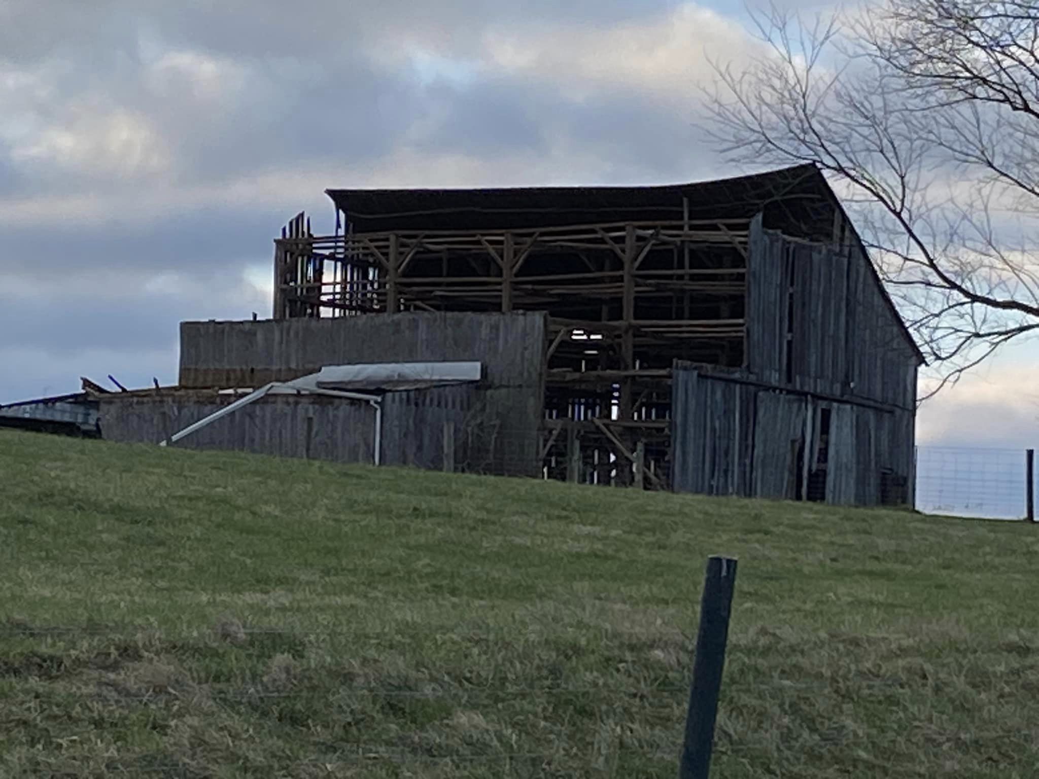
 Roof Blown off of Farm House, Fleming County (Courtesy of Fleming-Mason Energy) |
Photos
 |
 |
 |
 |
| Tree Snapped on Fonde Mountain (Courtesy of WRIL) |
Trees On Top of a Vehicle in Laurel County (Courtesy of Brandon Robinson WYMT) |
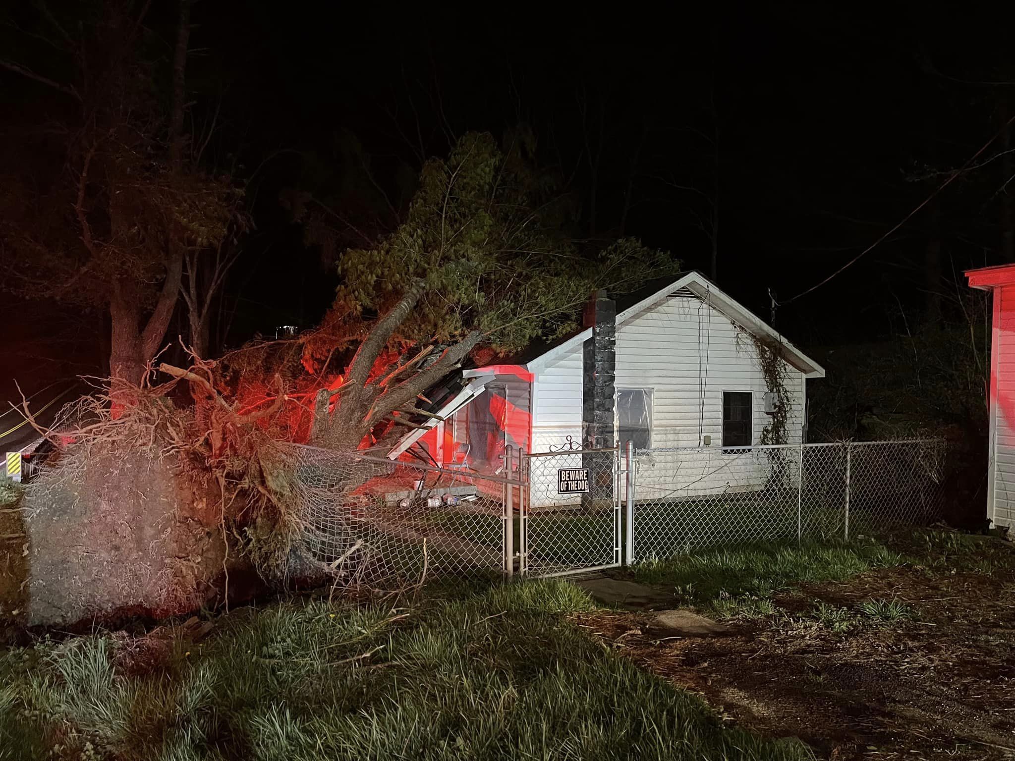
Tree Uprooted in Mount Sterling (Courtesy of Sleepy Raylan Givens) |
Power Pole Snapped in Hatfield (Courtesy of Hatfield Fire Department) |
 |
 |
 |
 |
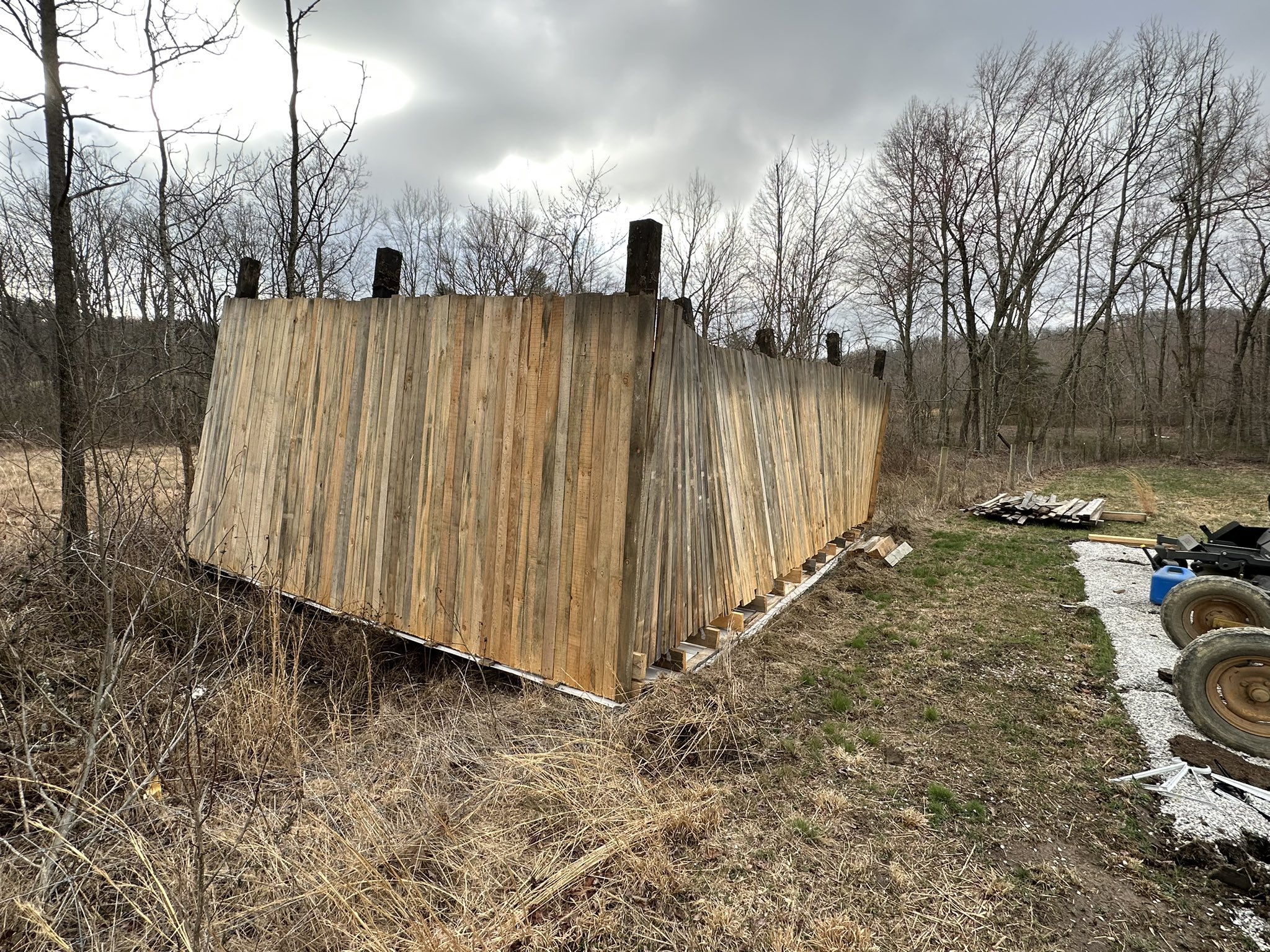
| Shelter Blown over a Fence in Mount Sterling (Courtesy of McKenzie Vance) |
Tree Debris on KY-66 in Bell County (Courtesy of WRIL) |
Large Pine Tree Leaning on Power Line (Courtesy of Jackson Energy) |
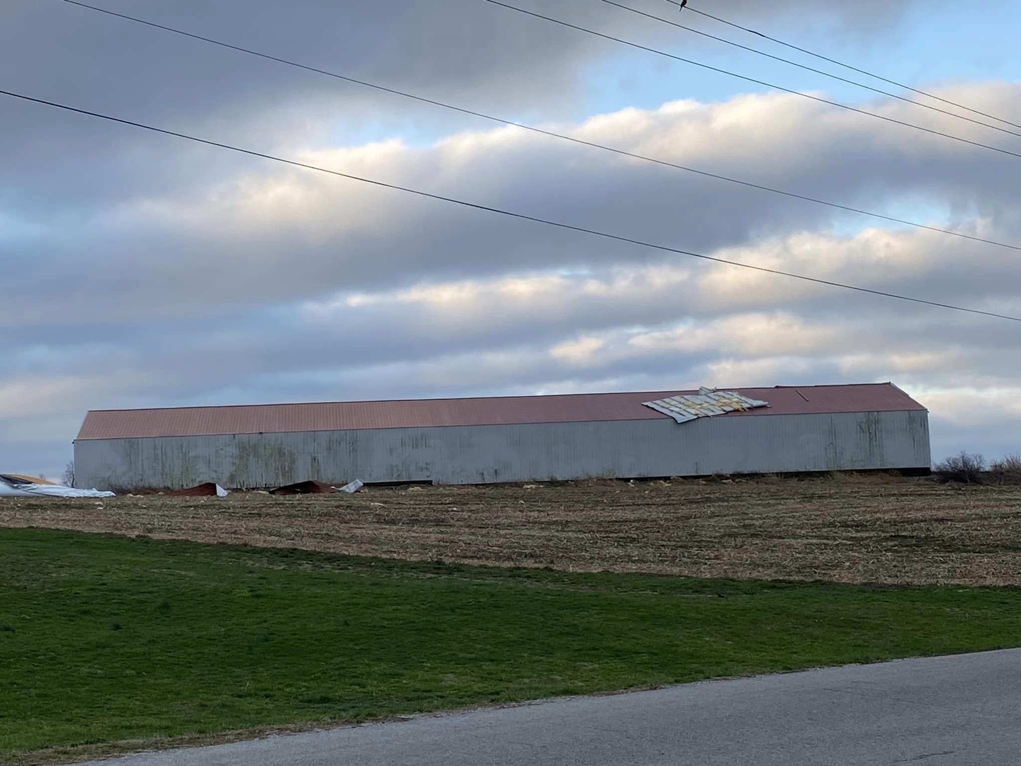
Severely Damaged Barn in Fleming County (Courtesy of Fleming-Mason Energy) |
 |
 |
 |
 |
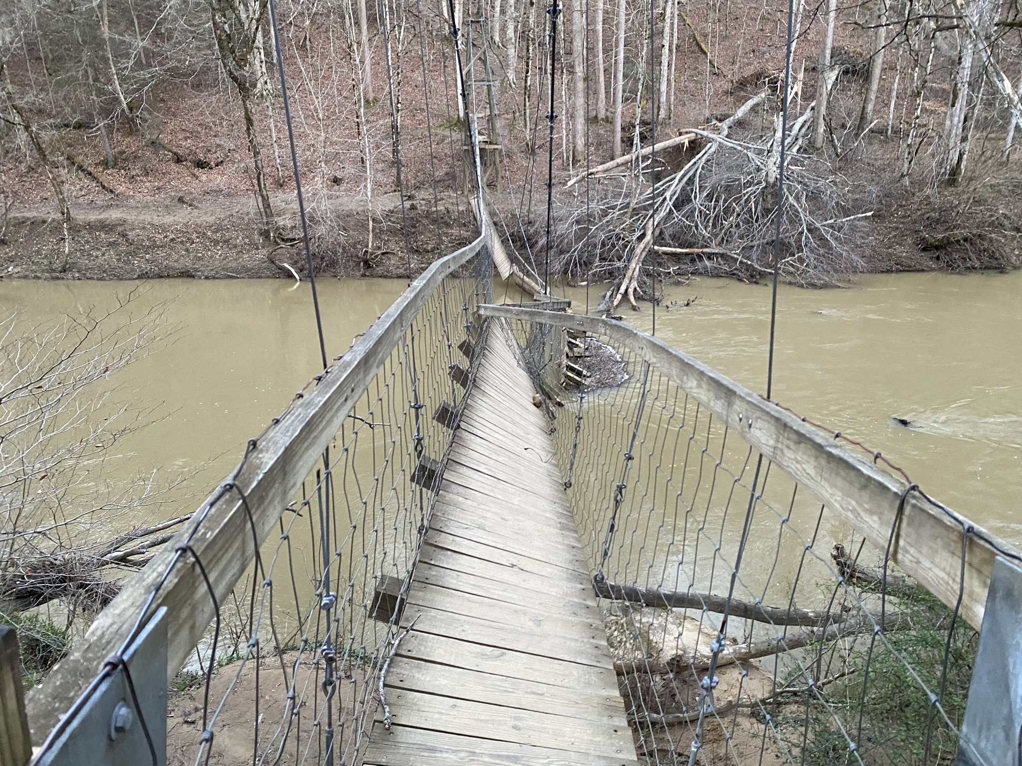
| Damaged Iconic Swinging Bridge Over the Red River (Courtesy of Wolfe County Search and Rescue) |
Tree on Powerline in Knox County (Courtesy of Richland Fire Department) |
Tree on House in Knox County (Courtesy of Richland Fire Department) |
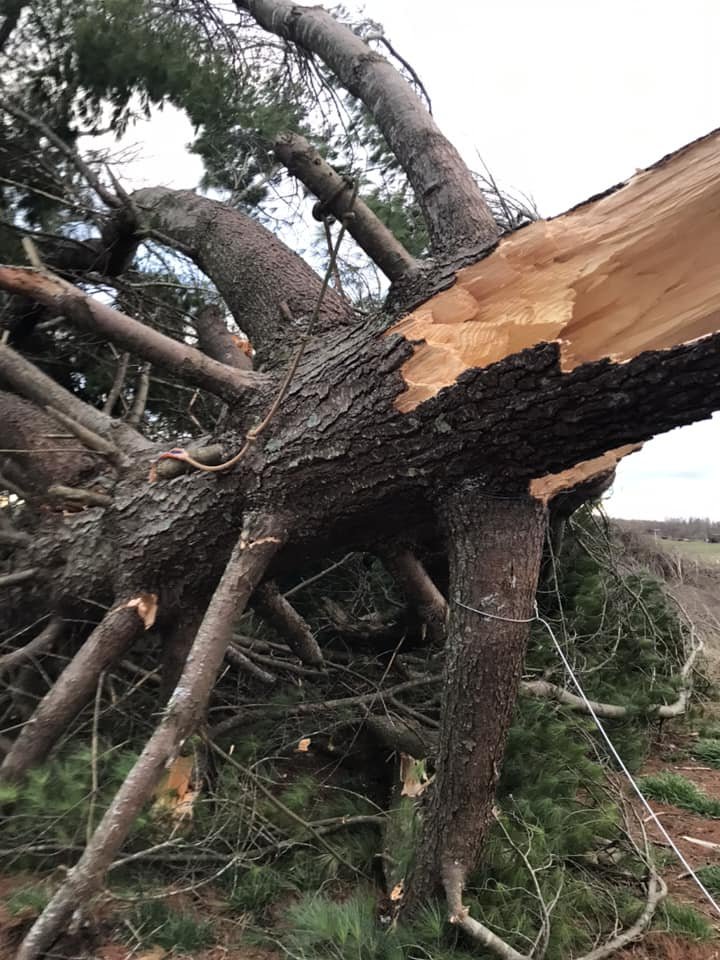
Large Snapped Pine Tree (Courtesy of Dillon Gaudet) |
 |
 |
 |
 |
| Roof Blown off of Home in Breathitt County (Courtesy of Johnny Ray Feltner) |
Barn Roof Damage in Fleming County (Courtesy of Fleming-Mason Energy) |
Shed Flipped in Bath County (Courtesy of Blake Little) |
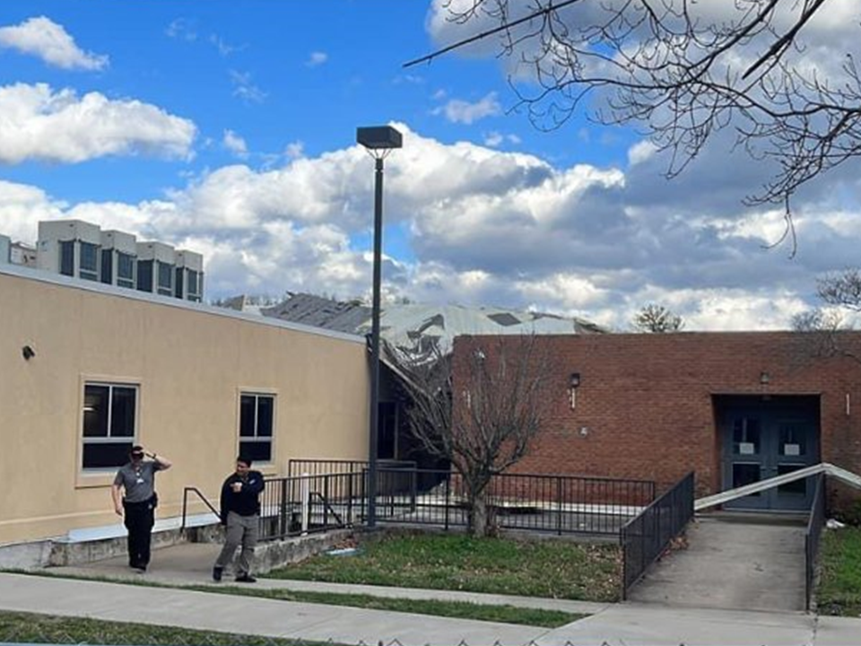
Roof Damage on Rockcastle Regional Hospital (Courtesy of Dillon Gaudet) |
Peak Wind Gusts
...HIGHEST WIND GUST REPORTS...

Location                     Speed     Time/Date       Lat/Lon/Elev (ft.)

...Kentucky...

...Bath County...
Owingsville 4 S              61 MPH    0700 PM 03/03   38.09N/83.76W/829

...Bell County...
Middlesboro Apt              37 MPH    0715 PM 03/03   36.62N/83.73W/1154
Yellow Creek RAWS            30 MPH    0726 PM 03/03   36.60N/83.70W/1089

...Breathitt County...
NWS Jackson                  65 MPH    0840 PM 03/03   37.60N/83.32W/1382
Jackson RAWS                 58 MPH    0856 PM 03/03   37.59N/83.32W/1388
Jackson 14 SE                54 MPH    0705 PM 03/03   37.43N/83.18W/1373
Jackson 14 ESE               30 MPH    0915 PM 03/03   37.46N/83.16W/833

...Clay County...
Peabody RAWS                 40 MPH    0701 PM 03/03   37.14N/83.58W/1464
Manchester                   36 MPH    0634 PM 03/03   37.10N/83.75W/869

...Harlan County...
Harlan Apt                   49 MPH    0722 PM 03/03   36.87N/83.37W/1551
Harlan 24 E                  49 MPH    0735 PM 03/03   36.92N/82.91W/4031

...Jackson County...
McKee 5 S                    45 MPH    0635 PM 03/03   37.36N/83.97W/1319

...Johnson County...
Paintsville 4 W              34 MPH    0655 PM 03/03   37.83N/82.88W/755

...Knott County...
Hindman 5 N                  56 MPH    0735 PM 03/03   37.41N/82.99W/1556

...Knox County...
Barbourville 3 E             50 MPH    0650 PM 03/03   36.87N/83.83W/1016

...Laurel County...
London-Corbin Apt            70 MPH    0621 PM 03/03   37.08N/84.07W/1212

...Letcher County...
Whitesburg 2 NW              39 MPH    0805 PM 03/03   37.13N/82.84W/1152

...Martin County...
Big Sandy Apt                52 MPH    0835 PM 03/03   37.75N/82.63W/1221
Big Sandy RAWS               48 MPH    0856 PM 03/03   37.75N/82.63W/1180

...McCreary County...
Whitley City 3 N             42 MPH    0725 PM 03/03   36.77N/84.48W/1312

...Menifee County...
Frenchburg 6 SSW             35 MPH    0850 PM 03/03   37.87N/83.65W/1253

...Montgomery County...
Mount Sterling Apt           60 MPH    0615 PM 03/03   38.05N/83.98W/1020

...Morgan County...
West Liberty 2 SW            68 MPH    0720 PM 03/03   37.90N/83.27W/1071

...Owsley County...
Booneville 2 S               47 MPH    0645 PM 03/03   37.45N/83.69W/784

...Pike County...
Pikeville 13 S               62 MPH    0345 PM 03/03   37.28N/82.52W/2774
Pike County Apt              44 MPH    0915 PM 03/03   37.57N/82.57W/1473

...Pulaski County...
Somerset Apt                 69 MPH    0555 PM 03/03   37.05N/84.62W/927
Somerset RAWS                62 MPH    0601 PM 03/03   37.05N/84.61W/921
Somerset 7 NNE               56 MPH    0635 PM 03/03   37.18N/84.56W/1085

...Rockcastle County...
Wabo                         65 MPH    0744 PM 03/03   37.31N/84.39W/1181

...Rowan County...
Triangle Mtn RAWS            65 MPH    0902 PM 03/03   38.18N/83.41W/1359
Morehead Apt                 53 MPH    0715 PM 03/03   38.22N/83.58W/1028
Morehead 4 NE                47 MPH    0700 PM 03/03   38.22N/83.48W/851

...Wayne County...
Monticello 4 NW              67 MPH    0515 PM 03/03   36.87N/84.90W/1045

...Wolfe County...
Koomer Ridge RAWS            62 MPH    0709 PM 03/03   37.78N/83.63W/1299
Storm Damage Reports
..TIME... ...EVENT... ...CITY LOCATION... ...LAT.LON...
..DATE... ....MAG.... ..COUNTY LOCATION..ST.. ...SOURCE....
..REMARKS..
0600 PM Non-Tstm Wnd Dmg 2 NNE Fonde 36.63N 83.85W
03/03/2023 Bell KY Public
A tree was blown down in the Fonde Mountain
Area. The even time is estimated.
0615 PM Non-Tstm Wnd Dmg Arjay 36.80N 83.65W
03/03/2023 Bell KY Public
Trees were blown down near the intersection
of Greencamp Road and KY 66.
0705 PM Non-Tstm Wnd Dmg Noetown 36.62N 83.75W
03/03/2023 Bell KY Public
A tree was down blocking a road. The event
time is estimated.
0720 PM Non-Tstm Wnd Dmg 2 SSE Jackson 37.53N 83.35W
03/03/2023 Breathitt KY NWS Employee
Tree down across Quicksand Road (Highway
1812).
0740 PM Non-Tstm Wnd Dmg 1 SE Haginsville 37.56N 83.29W
03/03/2023 Breathitt KY NWS Employee
Tress were blown down onto KY 30.
0745 PM Non-Tstm Wnd Dmg 1 SSW Stevenson 37.56N 83.27W
03/03/2023 Breathitt KY NWS Employee
A large tree was blown down onto KY 30.
0745 PM Non-Tstm Wnd Dmg Guage 37.60N 83.20W
03/03/2023 Breathitt KY NWS Employee
A large tree was blown down onto KY Highway
30 blocking the roadway.
0745 PM Non-Tstm Wnd Dmg Rousseau 37.59N 83.23W
03/03/2023 Breathitt KY NWS Employee
A large tree was blown down onto KY 30.
Another tree was blown down onto KY 30 just
west of this location near the former
Rousseau Elementary School.
0845 PM Non-Tstm Wnd Dmg 3 NE Guage 37.63N 83.17W
03/03/2023 Breathitt KY NWS Employee
A tree was blown down onto KY 30.
0845 PM Non-Tstm Wnd Dmg 1 NNE Camp Lewis 37.59N 83.18W
03/03/2023 Breathitt KY NWS Employee
A large pine tree was blown down onto KY 30
and just west of this location some roofing
material was removed from a residence.
0510 PM Non-Tstm Wnd Dmg Manchester 37.15N 83.77W
03/03/2023 Clay KY 911 Call Center
Trees were reported to have been blown down
in and near Manchester and throughout most
of Clay County starting after 5 PM and
continuing into the evening.
0515 PM Non-Tstm Wnd Dmg Manchester 37.15N 83.77W
03/03/2023 Clay KY 911 Call Center
Multiple trees down in or near Manchester
and throughout Clay County.
0530 PM Non-Tstm Wnd Dmg Big Creek 37.16N 83.57W
03/03/2023 Clay KY 911 Call Center
Trees were reported to have been blown down
in the Big Creek community.
0740 PM Non-Tstm Wnd Dmg Isonville 38.06N 83.05W
03/03/2023 Elliott KY 911 Call Center
Trees were reported to have been blown down.
0745 PM Non-Tstm Wnd Dmg 3 NE Farley 38.21N 83.19W
03/03/2023 Elliott KY 911 Call Center
Trees were blown down near the intersection
of KY 504 and Elmer Stone Road.
1210 PM Non-Tstm Wnd Dmg Weedon 37.71N 84.01W
03/03/2023 Estill KY Public
Trees were reported to have bene downed.
0615 PM Non-Tstm Wnd Dmg Weedon 37.71N 84.01W
03/03/2023 Estill KY Public
A stop sign was blown down. The event time
is estimated.
0625 PM Non-Tstm Wnd Dmg Irvine 37.70N 83.96W
03/03/2023 Estill KY Emergency Mngr
A roof was reported to have been blown off a
trailer. The time of event is estimated.
0720 PM Non-Tstm Wnd Dmg Ravenna 37.69N 83.95W
03/03/2023 Estill KY Emergency Mngr
Dispatch of 2 homes with severe roof damage
on Poplar St in Ravenna.
0715 PM Non-Tstm Wnd Dmg 1 NNE Flemingsburg Junc 38.47N 83.80W
03/03/2023 Fleming KY Utility Company
Roofing material was removed from a barn
along KY 170. The event time is estimated
from nearby reported wind gust times.
0715 PM Non-Tstm Wnd Dmg 1 ENE Nepton 38.44N 83.82W
03/03/2023 Fleming KY Utility Company
Significant loss of roofing material to a
home located near KY 170. The event time is
estimated from nearby reported wind gust
times.
0815 PM Non-Tstm Wnd Dmg Martin 37.58N 82.75W
03/03/2023 Floyd KY Dept of Highways
Crews responded to downed trees on KY 1428
in the City of Martin just past ARH Hospital
near mile point 1.0. The time of the event
is esimated.
0845 PM Non-Tstm Wnd Dmg 1 E Dotson 37.65N 82.84W
03/03/2023 Floyd KY NWS Employee
A few shingles were blown off of a
residence. The event occurred during the
evening and time of the event is estimated.
0845 PM Non-Tstm Wnd Dmg 2 ENE Dotson 37.65N 82.83W
03/03/2023 Floyd KY NWS Employee
A tree was blown down onto a utility line
and was resting on it.
0845 PM Non-Tstm Wnd Dmg 1 S Dock 37.61N 82.80W
03/03/2023 Floyd KY Utility Company
Trees were blown down and a power pole was
broken onto Hollybush Branch Road.
0850 PM Non-Tstm Wnd Dmg Allen City 37.61N 82.72W
03/03/2023 Floyd KY Public
Some siding was blown off of a home at a
residence per a social media post. The time
of the event is estimated.
1030 PM Non-Tstm Wnd Dmg 1 E Alvin 37.64N 82.68W
03/03/2023 Floyd KY Dept of Highways
KY 194 at the mouth of Slick Rock the road
is impassable due to Power lines and poles
down across the road. The event time is
estimated from nearby wind gust
observations.
0700 PM Non-Tstm Wnd Dmg Wallins Creek 36.82N 83.41W
03/03/2023 Harlan KY 911 Call Center
Trees were reported to have been blown down
in the Wallins Creek area.
0700 PM Non-Tstm Wnd Dmg Bledsoe 36.92N 83.37W
03/03/2023 Harlan KY 911 Call Center
Trees were reported to have been blown down
in the Bledsoe area.
0725 PM Non-Tstm Wnd Dmg Cranks 36.76N 83.17W
03/03/2023 Harlan KY 911 Call Center
Trees were reported to have been blown down
in the Cranks area along US 421.
0725 PM Non-Tstm Wnd Dmg Harlan 36.84N 83.32W
03/03/2023 Harlan KY 911 Call Center
Trees were reported to have been blown down
throughout the evening on most highways in
Harlan County including in the Harlan
vicinity.
0630 PM Non-Tstm Wnd Dmg Annville 37.32N 83.96W
03/03/2023 Jackson KY 911 Call Center
Trees were reported to have been blown down.
0630 PM Non-Tstm Wnd Dmg Mckee 37.43N 84.00W
03/03/2023 Jackson KY 911 Call Center
Trees were reported to have been blown down.
0635 PM Non-Tstm Wnd Dmg Gray Hawk 37.39N 83.94W
03/03/2023 Jackson KY 911 Call Center
Trees were reported to have been blown down.
0635 PM Non-Tstm Wnd Dmg Tyner 37.35N 83.90W
03/03/2023 Jackson KY 911 Call Center
Trees were reported to have been blown down.
0615 PM Non-Tstm Wnd Dmg Elna 37.91N 82.96W
03/03/2023 Johnson KY Utility Company
A tree was blown down onto KY 3214 and also
onto powerlines along the roadway.
0835 PM Non-Tstm Wnd Dmg Boons Camp 37.83N 82.70W
03/03/2023 Johnson KY Public
A tree was blown down onto KY Route 40
blocking the roadway.
0735 PM Non-Tstm Wnd Dmg Talcum 37.37N 83.11W
03/03/2023 Knott KY Dept of Highways
KY 1087 was blocked by multiple downed trees
on the roadway. Time of the event is
estimated from peak wind gusts of nearby
observations.
0735 PM Non-Tstm Wnd Dmg Emmalena 37.34N 83.07W
03/03/2023 Knott KY Dept of Highways
KY 550 was blocked by a tree blown down onto
the roadway. Time of the event is estimated
from peak wind gusts of nearby observations.
0810 PM Non-Tstm Wnd Dmg Cordia 37.28N 83.12W
03/03/2023 Knott KY Public
Report from mPING: 1-inch tree limbs broken;
Shingles blown off.
0645 PM Non-Tstm Wnd Dmg Barbourville 36.87N 83.88W
03/03/2023 Knox KY 911 Call Center
Trees were reported to have been blown down
in and near Barbourville as well as
countywide throughout Knox County.
0100 PM Non-Tstm Wnd Dmg 1 SSW London-Corbin Air 37.07N 84.08W
03/03/2023 Laurel KY Trained Spotter
Trees and powerlines were blown down.
0615 PM Non-Tstm Wnd Dmg East Bernstadt 37.19N 84.12W
03/03/2023 Laurel KY Public
A tree was blown down near a home in East
Bernstadt. Event time is estimated.
0730 PM Non-Tstm Wnd Dmg 1 SSW London-Corbin Air 37.07N 84.08W
03/03/2023 Laurel KY Trained Spotter
More pine trees were blown down with a large
area without power 4 miles S of London.
0645 PM Non-Tstm Wnd Dmg 2 NW Banford 37.53N 83.84W
03/03/2023 Lee KY 911 Call Center
Trees were reported to have been blown down
in the Hail Ridge area.
0645 PM Non-Tstm Wnd Dmg 1 N Delvinta 37.51N 83.79W
03/03/2023 Lee KY 911 Call Center
Trees were reported to have been blown down
in the Hamilton Ridge area.
0650 PM Non-Tstm Wnd Dmg Heidelberg 37.55N 83.77W
03/03/2023 Lee KY 911 Call Center
Trees were reported to have been blown down
on Sturgeon Street.
0655 PM Non-Tstm Wnd Dmg White Ash 37.56N 83.73W
03/03/2023 Lee KY Public
A couple trees down on White Ash Road in
Beattyville near the railroad crossing
according to a Twitter post. The time of the
event is estimated.
0655 PM Non-Tstm Wnd Dmg Proctor 37.57N 83.72W
03/03/2023 Lee KY 911 Call Center
Trees were reported to have been blown down
in the Spicer Ridge area.
0700 PM Non-Tstm Wnd Dmg 1 N Maloney 37.60N 83.68W
03/03/2023 Lee KY 911 Call Center
Trees were reported to have been blown down
on Little Puncheon Road.
0700 PM Non-Tstm Wnd Dmg Saint Helens 37.58N 83.65W
03/03/2023 Lee KY 911 Call Center
Trees were reported to have been blown down
onto Candyland Lane.
0705 PM Non-Tstm Wnd Dmg 2 E Mount Olive 37.61N 83.69W
03/03/2023 Lee KY Public
A member of the public reported that their
new home construction was partially
destroyed and large amounts of plywood were
scattered during the wind event. The event
time is estimated from nearby reports and
peak gust times and occurred prior to 9 PM
EST.
0710 PM Non-Tstm Wnd Dmg 2 ENE Bobs Fork 37.18N 83.48W
03/03/2023 Leslie KY 911 Call Center
In the Hollins Fork community, a tree fell
onto a powerline causing a transformer to
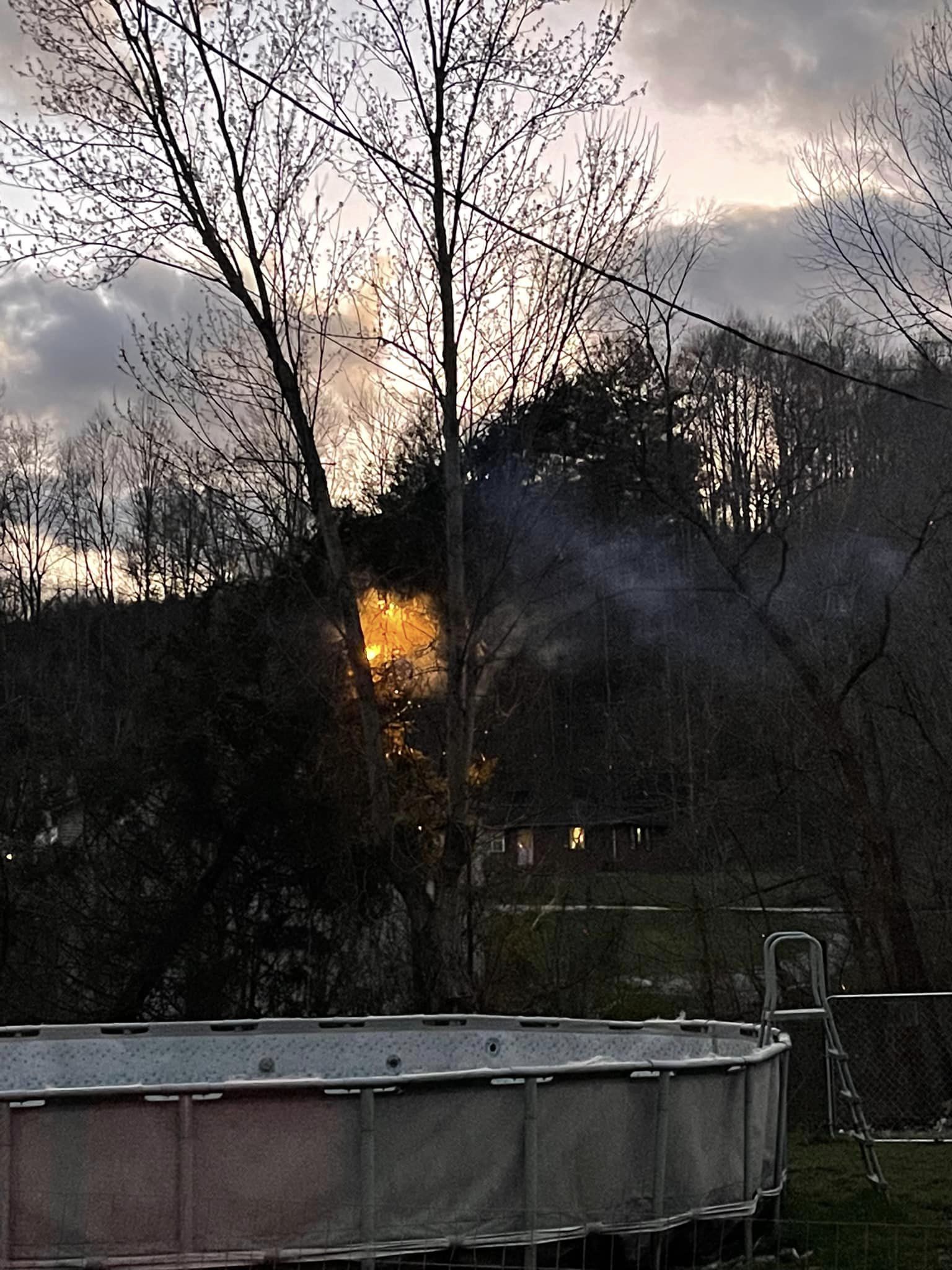
blow. This in turn caught on fire and
ignited a brushfire on the surrounding
terrain.
0715 PM Non-Tstm Wnd Dmg 2 ENE Hosea 37.15N 83.42W
03/03/2023 Leslie KY 911 Call Center
A tree was blown down onto the roadway and
car ran into it. Time is estimated based on
peak winds of nearby observations.
0730 PM Non-Tstm Wnd Dmg Mozelle 37.00N 83.40W
03/03/2023 Leslie KY 911 Call Center
A tree fell onto a porch of a residence.
0930 PM Non-Tstm Wnd Dmg Haymond 37.18N 82.69W
03/03/2023 Letcher KY Dept of Highways
KY 805 between MM 4 and 6 both lanes blocked
due to a tree down and phone lines down.
0815 PM Non-Tstm Wnd Dmg 1 S Cisco 37.83N 83.13W
03/03/2023 Magoffin KY 911 Call Center
Trees were reported to have been blown down
onto Pricy Creek Road.
0820 PM Non-Tstm Wnd Dmg 1 NNE Tella 37.83N 83.08W
03/03/2023 Magoffin KY 911 Call Center
Trees were reported to have been blown down
in the Coon Creek community.
0830 PM Non-Tstm Wnd Dmg Royalton 37.68N 83.02W
03/03/2023 Magoffin KY 911 Call Center
Trees were reported to have been blown down
in the Royalton area.
0835 PM Non-Tstm Wnd Dmg 1 NNW Ivyton 37.72N 82.98W
03/03/2023 Magoffin KY 911 Call Center
Trees were reported to have been blown down
onto east Mountain Parkway.
0845 PM Non-Tstm Wnd Dmg 1 WSW Pilgrim 37.80N 82.43W
03/03/2023 Martin KY 911 Call Center
Trees were reported to have been blown down.
0850 PM Non-Tstm Wnd Dmg Bradbury 37.82N 82.51W
03/03/2023 Martin KY 911 Call Center
Trees were blown down onto Coldwater Road.
0900 PM Non-Tstm Wnd Dmg Tomahawk 37.87N 82.59W
03/03/2023 Martin KY 911 Call Center
Teo trees were reported to have been blown
down on to the roadway.
0440 PM Non-Tstm Wnd Dmg Pine Knot 36.66N 84.44W
03/03/2023 McCreary KY Public
A large tree was blown down per picture
posted to social media.
0850 PM Non-Tstm Wnd Dmg 1 W Cornwell 37.96N 83.73W
03/03/2023 Menifee KY NWS Employee
In the Cornwell area, at least two homes
lost shingles, two metal barn roofs had tin
sheets partially blown off, and at least one
home had several pieces of siding blown off.
Time estimated.
0615 PM Non-Tstm Wnd Dmg Mount Sterling 38.06N 83.95W
03/03/2023 Montgomery KY Public
A tree was uprooted at a residence in Mount
Sterling. The time of the event is estimated
from the peak gust at nearby KIOB airport.
0730 PM Non-Tstm Wnd Dmg Booneville 37.48N 83.68W
03/03/2023 Owsley KY Law Enforcement
A tree was blown down onto KY 11.
0735 PM Non-Tstm Wnd Dmg 1 WNW Lerose 37.49N 83.64W
03/03/2023 Owsley KY Emergency Mngr
A 3 foot diameter pine tree was blown down
at a residence along KY 30 East. 3 hardwood
trees down between Booneville and Lerose.
Reported by Assistant Emergency Manager and
Retired NWS Employee. The time of the event
is estimated from nearby reports and times
of observed wind gusts.
0555 PM Non-Tstm Wnd Dmg 1 WNW Lamont 37.36N 83.33W
03/03/2023 Perry KY 911 Call Center
Trees were reported to have been blown down
onto KY 28 near Chavies School Road near
Chavies.
0655 PM Non-Tstm Wnd Dmg 2 NNW Hazard 37.28N 83.21W
03/03/2023 Perry KY 911 Call Center
Trees were reported to have been blown down
onto Combs Road.
0705 PM Non-Tstm Wnd Dmg Viper 37.18N 83.15W
03/03/2023 Perry KY 911 Call Center
Trees were reported to have been blown down
onto KY 7 in and near Viper.
0745 PM Non-Tstm Wnd Dmg 2 SE Ned 37.39N 83.25W
03/03/2023 Perry KY Public
Tree damage and/or some roofing material
lost near Ned due to wind gusts via mPING.
0815 PM Non-Tstm Wnd Dmg 1 NE Conder 37.69N 82.36W
03/03/2023 Pike KY Fire Dept/Rescue
A power pole was snapped. The event time is
estimated.
0945 PM Non-Tstm Wnd Dmg 1 NW Stanton 37.85N 83.87W
03/03/2023 Powell KY NWS Employee
Medium sized fruit tree down near the
intersection of highways 2026 and 2073 in
Stanton. Time estimated.
0425 PM Non-Tstm Wnd Dmg 1 NNE Somerset 37.09N 84.61W
03/03/2023 Pulaski KY Public
A pine tree was uprooted and fell onto a
home leading to significant damage. The
event time is estimated.
0452 PM Non-Tstm Wnd Dmg 1 WSW Hogue 37.16N 84.73W
03/03/2023 Pulaski KY Broadcast Media
Power pole snapped along KY-1676 near
Science Hill.
0537 PM Non-Tstm Wnd Dmg 1 SE Hogue 37.15N 84.69W
03/03/2023 Pulaski KY Public
Report from mPING: Trees uprooted or snapped
with some roof damage.
0549 PM Non-Tstm Wnd Dmg 1 SE Hogue 37.15N 84.69W
03/03/2023 Pulaski KY Public
Additional tree damage and some roofing
materials blown off in the Hogue area from
gradient winds.
0630 PM Non-Tstm Wnd Dmg Eubank 37.28N 84.65W
03/03/2023 Pulaski KY Public
At least 10 trees were blown down or
uprooted on the hillside near a residence.
Pictures were posted o social media.
0720 PM Non-Tstm Wnd Dmg Science Hill 37.18N 84.64W
03/03/2023 Pulaski KY Public
Trees were blown down in the Science Hill
area including along KY 635.
0605 PM Non-Tstm Wnd Dmg Brodhead 37.40N 84.42W
03/03/2023 Rockcastle KY Public
A large coniferous tree was down.
0620 PM Non-Tstm Wnd Dmg 2 WSW Jellico Creek 36.67N 84.27W
03/03/2023 Whitley KY 911 Call Center
Trees were reported to have been blown down
in the Jellico Creek community.
0630 PM Non-Tstm Wnd Dmg Walden 36.85N 84.17W
03/03/2023 Whitley KY 911 Call Center
Trees were reported to have been blown down
onto KY 511 in northern Whitley County.
0630 PM Non-Tstm Wnd Dmg 2 WSW Clio 36.81N 84.23W
03/03/2023 Whitley KY 911 Call Center
Trees were reported to have been blown down
in the Canada Town community.
0710 PM Non-Tstm Wnd Dmg Red River Gorge 37.83N 83.62W
03/03/2023 Wolfe KY Park/Forest Srvc
Strong winds pulled down a tree which landed
on and destroyed the iconic suspension
bridge that connects the Sheltowee Trace
National Recreation Trail across the Red
River in the Red River Gorge along the
Menifee and Wolfe county border. The event
time is estimated from peak wind gust at a
nearby RAWS station, Koomer Ridge.
0720 PM Non-Tstm Wnd Dmg Pence 37.63N 83.48W
03/03/2023 Wolfe KY Public
A barn that was located just off of Cave
Branch Road and a short distance from KY
1261 was demolished by the strong wind gusts
and resulted in the death of livestock. The
event time is estimated from wind gusts from
nearby observations.
0725 PM Non-Tstm Wnd Dmg 1 SSE Campton 37.73N 83.54W
03/03/2023 Wolfe KY Public
A power pole was blown down near Dairy
Queen.
Environment
An intense low pressure system (as shown in Figure1) lifted from the southern Plains on the evening of March 2nd to along the Ohio River during the day on March 3rd. The system reached its lowest pressure reading of approximately 976 mb as it passed Evansville Indiana. The strongest winds occurred just behind the secondary cold front passage.
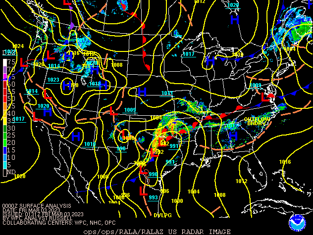 |
| Figure 1: Surface Analysis 7 PM March 2nd through 1 AM March 4th |
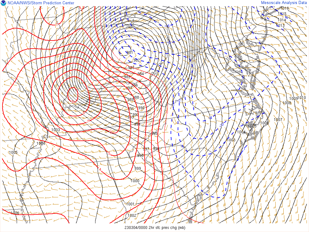
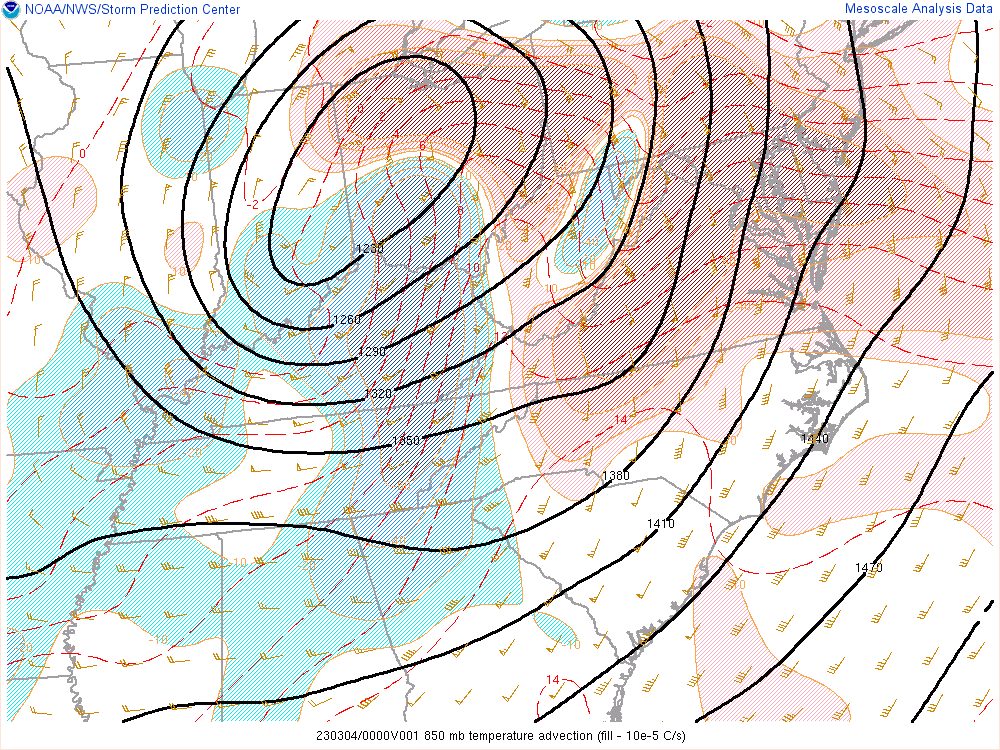
Across eastern Kentucky, surface winds peaked within a couple hours of either side of 7 PM, March 3rd. Figure 1 shows these winds coinciding with a robust surface pressure gradient and sharp 2-hour surface pressure rises. At 850 mb, intense cold air advection steepened low-level lapse rates which allowed momentum from the wind at that level (analyzed at 55 to 65 knots) to mix down in the form of strong to damaging wind gusts. The resulting sharp surface temperature gradient is evident from the analysis in Figure 4.
 |
 |
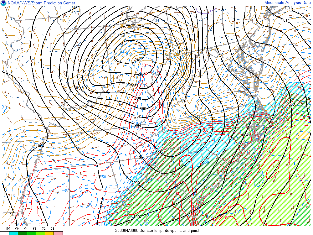 |
| Figure 2: Surface Pressure and 2-hr Surface Pressure Change at 7 PM March 3rd | Figure 3: 850 mb Winds and Temperature Advection at 7 PM March 3rd | Figure 4: Surface Temperature, Dewpoint, and Mean Sea Level Pressure at 7 PM March 3rd |
 |
Media use of NWS Web News Stories is encouraged! Please acknowledge the NWS as the source of any news information accessed from this site. |
|

