Overview
|
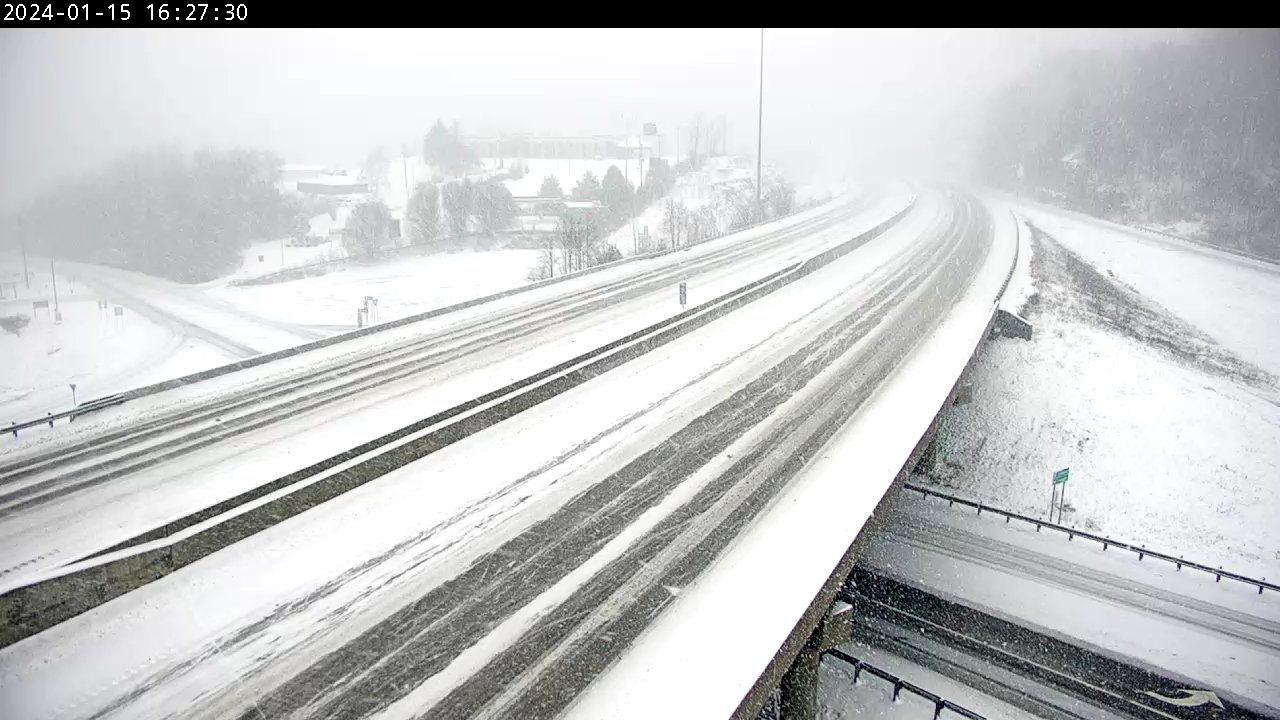
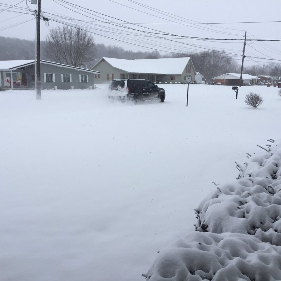
Arctic air and a winter storm kicked off the 3rd week of January 2024. The frigid air mass seeped into eastern Kentucky on Sunday, January 14th, following the passage of a shallow arctic cold front. That front eventually stalled along the spine of the Appalachians by late in the day. Temperatures fell into the 10s and 20s behind the front -- more than cold enough for snow. The first of multiple disturbances, passing through a deep upper level trough over much of the Lower 48 east of the Rockies, induced moist and relatively warm air to overrun the cold arctic air mass by Sunday evening, causing snow to develop across eastern Kentucky during the evening of the 14th. Light to moderate snowfall continued into Monday morning with the heaviest amounts, exceeding 4 inches at some locations, falling between the Hal Roger Parkway/KY-80 corridor and the Mountain Parkway. Temperatures remained cold, only ranging in the teens to middle 20s. After periods of lighter snow for most of the day on Monday, the 15th, another disturbance caused steadier snow to develop from the southwest on Monday evening. The snow eventually tapered from the west on Tuesday morning, the 16th. The heavier snowfall with this second round was generally focused south of the Mountain Parkway with some locations again picking up in excess of 4 inches. Many locations saw snowfall tallies approaching a half foot or more. The highest snowfall report was 9.3 inches about 4 miles northeast of Booneville. As the storm moved away on Tuesday, the arctic air remained entrenched over eastern Kentucky as strong high pressure built northeastward from the Tennessee Valley. Temperatures remained largely in the 10s to lower 20s through Tuesday afternoon once the snowfall ended. With minimal cloud cover and light wind, temperatures dropped quickly after sunset Tuesday evening, especially in valleys with deep snow cover. By early Wednesday morning, the 17th, many locations were below zero, including below -10ºF in many of the sheltered valleys. The Monticello Airport took first place as the coldest location in eastern Kentucky, bottoming out at frigid -22ºF. In fact, Monticello not only registered the coldest temperature for the Commonwealth, but also the entire Continental United States for that night. |
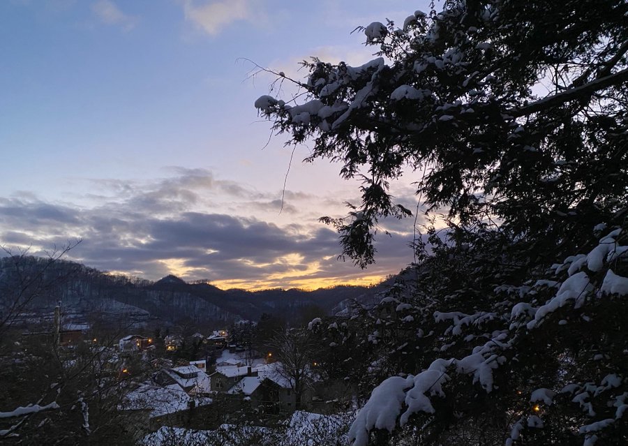
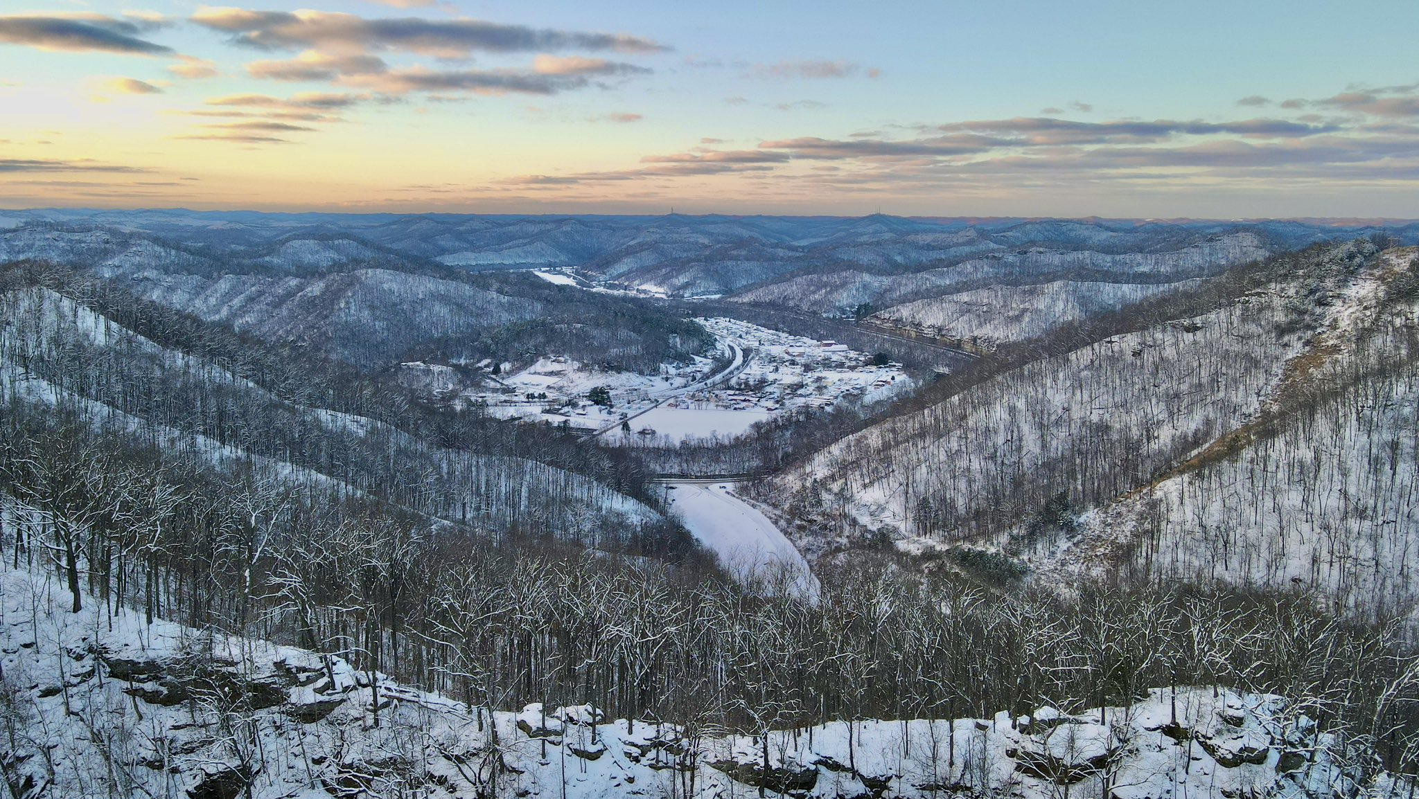
 Bitter Cold Sunset at Jenny Wiley State Park on January 16th (Courtesy of Allen Bolling) |
Snowfall Reports
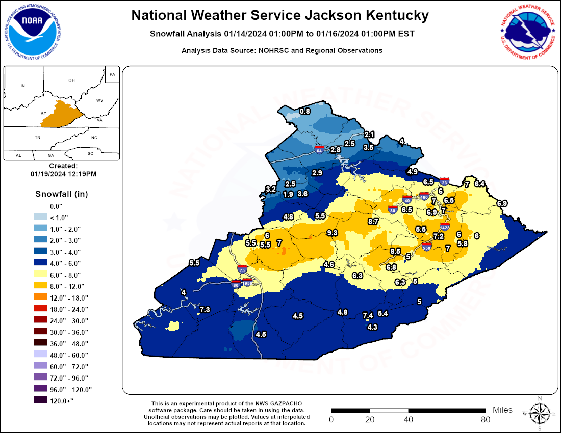
...STORM TOTAL SNOWFALL REPORTS ENDING TUESDAY MORNING, JANUARY 16TH...

Location                     Amount    Time/Date       Lat/Lon

...Kentucky...

...Bell County...
2 SSW Beverly                4.8 in    0915 AM 01/16   36.91N/83.55W

...Breathitt County...
NWS Office/Julian Carroll Ai 8.7 in    0700 AM 01/16   37.59N/83.32W

...Clay County...
Oneida                       4.6 in    0700 AM 01/16   37.27N/83.65W

...Elliott County...
9 SSE Olive Hill             4.0 in    0900 AM 01/16   38.19N/83.08W

...Estill County...
Wagersville                  4.8 in    1000 AM 01/16   37.63N/83.95W
Cressy                       3.2 in    0800 AM 01/16   37.83N/84.04W

...Fleming County...
Elizaville                   0.8 in    0700 AM 01/16   38.42N/83.83W

...Floyd County...
1 SE Bosco                   7.3 in    1000 AM 01/16   37.50N/82.83W
Prestonsburg                 7.0 in    0900 AM 01/16   37.67N/82.77W
East Point                   7.0 in    0945 AM 01/16   37.74N/82.79W
Hi Hat                       7.0 in    0945 AM 01/16   37.39N/82.73W
3 WSW Prestonsburg           6.9 in    0700 AM 01/16   37.66N/82.83W
1 WSW Prestonsburg           6.8 in    0900 AM 01/16   37.67N/82.78W
Grethel                      6.0 in    0945 AM 01/16   37.49N/82.65W
2 S Grethel                  5.8 in    0730 AM 01/16   37.47N/82.65W
Hippo                        5.5 in    0945 AM 01/16   37.53N/82.86W

...Harlan County...
3 N arlan                    7.4 in    0916 AM 01/16   36.88N/83.31W
5 NE Baxter                  5.4 in    0700 AM 01/16   36.90N/83.25W
Blair                        5.0 in    0931 AM 01/16   36.99N/82.95W
1 S Harlan                   4.3 in    0600 AM 01/16   36.83N/83.33W
Harlan                       3.5 in    1000 AM 01/16   36.85N/83.32W

...Jackson County...
McJee                        7.0 in    0945 AM 01/16   37.43N/84.00W
Sandgap                      6.0 in    0900 AM 01/16   37.49N/84.09W
8 W McKee                    5.5 in    0759 AM 01/16   37.43N/84.14W
1 S Eglon                    5.5 in    0800 AM 01/16   37.45N/84.13W

...Johnson County...
West Van Lear                6.5 in    0835 AM 01/16   37.79N/82.78W
Van Lear                     6.5 in    0930 AM 01/16   37.77N/82.75W
2 WSW Galen                  6.5 in    0945 AM 01/16   37.88N/82.84W
1 E Painstville              6.0 in    0700 AM 01/16   37.82N/82.79W

...Knott County...
Carrie                       5.0 in    0800 AM 01/16   37.33N/83.03W

...Knox County...
Barbourville                 4.5 in    0930 AM 01/16   36.88N/83.88W

...Lee County...
4 N Beattyville              5.5 in    0900 AM 01/16   37.63N/83.72W

...Leslie County...
Thousandsticks               6.3 in    0806 AM 01/16   37.19N/83.43W

...Magoffin County...
Salyersville Water Works     6.5 in    0800 AM 01/16   37.74N/83.07W
Hendricks                    6.5 in    1000 AM 01/16   37.70N/83.12W

...Martin County...
Inez                         7.0 in    1000 AM 01/16   37.87N/82.54W
2 E Inez                     6.4 in    0700 AM 01/16   37.87N/82.52W

...Menifee County...
2 ENE Means                  2.9 in    0700 AM 01/16   37.96N/83.74W

...Morgan County...
5 E Crockett                 4.9 in    0800 AM 01/16   37.96N/83.02W

...Owsley County...
4 ENE Booneville             9.3 in    0700 AM 01/16   37.50N/83.62W

...Perry County...
1 SSW Ary                    8.5 in    0920 AM 01/16   37.37N/83.15W
Hazard Water Works           6.8 in    0700 AM 01/16   37.25N/83.18W
2 NW Daisy                   6.3 in    1000 AM 01/16   37.14N/83.11W

...Pike County...
Whitepost                    6.9 in    1000 AM 01/16   37.73N/82.35W
Pikeville                    6.0 in    1000 AM 01/16   37.48N/82.52W

...Powell County...
1 SSE Stanton                3.6 in    0700 AM 01/16   37.83N/83.85W
1 WNW Clay City              2.5 in    0700 AM 01/16   37.87N/83.93W
2 W Stanton                  1.9 in    0700 AM 01/16   37.86N/83.90W

...Pulaski County...
4 SSE Burnside               7.3 in    0700 AM 01/16   36.93N/84.58W
Eubank                       5.5 in    0935 AM 01/16   37.28N/84.66W
1 SW Pulaski County Park     4.0 in    0945 AM 01/16   37.06N/84.72W

...Rowan County...
1 ESE Crix                   3.5 in    1000 AM 01/16   38.15N/83.35W
Cave Run Lake                2.8 in    0700 AM 01/16   38.12N/83.53W
2 NNE Lakeview Heights       2.5 in    1000 AM 01/16   38.18N/83.49W
6 NE Morehead                2.1 in    0721 AM 01/16   38.24N/83.34W

...Whitley County...
1 NE Williamsburg            4.5 in    1000 AM 01/16   36.74N/84.16W

Observations are collected from a variety of sources with varying
equipment and exposures. We thank all volunteer weather observers
for their dedication. Not all data listed are considered official.
Photos
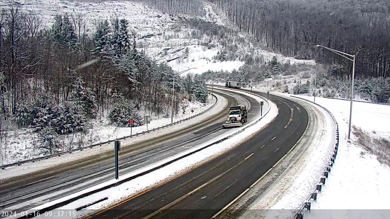 |
| Plow Clearing US-23 at Pound Gap on January 16th (Letcher County) (Courtesy of KYTC) |
Coldest Temperature Reports
...LOW TEMPERATURE REPORTS ON WEDNESDAY, JANUARY 17TH...

Location                     Temp      Time/Date       Lat/Lon

...Kentucky...

...Bath County...
Owingsville 4 S                2 F     0555 AM 01/17   38.09N/83.76W

...Bell County...
Middlesboro Apt               -7 F     0735 AM 01/17   36.62N/83.73W
Yellow Creek RAWS             -4 F     0826 AM 01/17   36.60N/83.70W

...Breathitt County...
Jackson RAWS                   0 F     0756 AM 01/17   37.59N/83.32W
NWS Jackson                    2 F     0753 AM 01/17   37.60N/83.32W

...Clay County...
Manchester                    -8 F     0829 AM 01/17   37.10N/83.75W
Oneida                        -4 F     0715 AM 01/17   37.27N/83.65W
Peabody RAWS                   1 F     0601 AM 01/17   37.14N/83.58W

...Estill County...
Irvine                        -3 F     0830 AM 01/17   37.71N/84.07W
Cressy                         3 F     0800 AM 01/17   37.83N/84.03W

...Floyd County...
Prestonsburg 3 WSW            -5 F     0700 AM 01/17   37.66N/82.83W

...Harlan County...
Harlan 24 E                   -6 F     0515 AM 01/17   36.92N/82.91W

...Jackson County...
McKee 5 S                     -3 F     0650 AM 01/17   37.36N/83.97W

...Johnson County...
Paintsville 4 W              -12 F     0820 AM 01/17   37.83N/82.88W
Paintsville 1 E               -3 F     0700 AM 01/17   37.82N/82.78W

...Knott County...
Carr Creek                    -3 F     0700 AM 01/17   37.23N/83.03W
Hindman 5 N                    1 F     0800 AM 01/17   37.41N/82.99W

...Knox County...
Barbourville 3 E             -12 F     0825 AM 01/17   36.87N/83.83W

...Laurel County...
London-Corbin Apt             -4 F     0753 AM 01/17   37.08N/84.07W
I-75 NB @ KY-80 (London)       0 F     0720 AM 01/17   37.15N/84.11W
I-75 @ KY-770 (Laurel)         2 F     0745 AM 01/17   36.98N/84.11W

...Lee County...
Beattyville 4n                -2 F     0900 AM 01/17   37.63N/83.72W

...Letcher County...
Whitesburg 2 NW               -1 F     0825 AM 01/17   37.13N/82.84W
Whitesburg 2 SE                0 F     0700 AM 01/17   37.10N/82.80W
US-119 @ Pine Mountain (Whit   1 F     0705 AM 01/17   37.08N/82.81W

...Magoffin County...
Salyersville                  -8 F     0800 AM 01/17   37.74N/83.07W

...Martin County...
Inez 2 E                      -8 F     0700 AM 01/17   37.87N/82.52W
Big Sandy RAWS                 4 F     0756 AM 01/17   37.75N/82.63W
Big Sandy Apt                  5 F     0835 AM 01/17   37.75N/82.63W

...McCreary County...
Whitley City 3 N              -2 F     0750 AM 01/17   36.77N/84.48W

...Montgomery County...
Mount Sterling Apt             1 F     0655 AM 01/17   38.05N/83.98W

...Morgan County...
Licking River                 -1 F     0815 AM 01/17   37.94N/83.30W
Wellington                     0 F     0830 AM 01/17   37.97N/83.43W
West Liberty 2 SW              2 F     0805 AM 01/17   37.90N/83.27W

...Owsley County...
Booneville 2 S               -11 F     0820 AM 01/17   37.45N/83.69W

...Perry County...
Hazard Apt                     3 F     0855 AM 01/17   37.39N/83.26W

...Pike County...
Kimper                        -3 F     0809 AM 01/17   37.52N/82.36W
Pikeville                     -2 F     0847 AM 01/17   37.45N/82.48W
Pikeville 13 S                -1 F     0815 AM 01/17   37.28N/82.52W
Pikeville                      3 F     0815 AM 01/17   37.45N/82.52W
Pike County Apt                4 F     0755 AM 01/17   37.57N/82.57W

...Powell County...
Stanton 2 W                   -2 F     0700 AM 01/17   37.86N/83.90W

...Pulaski County...
Somerset 7 NNE               -10 F     0520 AM 01/17   37.18N/84.56W
Eubank                        -9 F     0755 AM 01/17   37.30N/84.49W
Ferguson                      -6 F     0535 AM 01/17   37.07N/84.60W
Somerset 1 SSW                -4 F     0535 AM 01/17   37.04N/84.62W
Somerset Apt                  -4 F     0635 AM 01/17   37.05N/84.62W
Somerset RAWS                 -4 F     0701 AM 01/17   37.05N/84.61W
Somerset                       0 F     0240 AM 01/17   37.10N/84.60W
Burnside                       2 F     0635 AM 01/17   37.00N/84.59W
US-27 @ KY-90 (Burnside)       2 F     0640 AM 01/17   37.00N/84.61W
Somerset                       4 F     0915 AM 01/17   37.12N/84.56W

...Rockcastle County...
Broadhead                     -8 F     0415 AM 01/17   37.41N/84.37W

...Rowan County...
I-64 @ KY-801 (Farmers)        3 F     0718 AM 01/17   38.18N/83.56W
Morehead 4 NE                  4 F     0725 AM 01/17   38.22N/83.48W
Triangle Mtn RAWS              4 F     0802 AM 01/17   38.18N/83.41W
Morehead Apt                   5 F     0815 AM 01/17   38.22N/83.58W

...Wayne County...
Monticello Apt               -22 F     0656 AM 01/17   36.85N/84.85W
Monticello                    -3 F     0815 AM 01/17   36.85N/84.89W
Monticello 4 NW               -2 F     0730 AM 01/17   36.87N/84.90W
Monticello                     3 F     0815 AM 01/17   36.96N/84.83W

...Whitley County...
I-75 NB @ KY Welcome Center   -8 F     0815 AM 01/17   36.62N/84.11W
Williamsburg                  -3 F     0807 AM 01/17   36.84N/84.21W
Williamsburg Apt              -2 F     0815 AM 01/17   36.80N/84.20W

...Wolfe County...
Koomer Ridge RAWS              0 F     0509 AM 01/17   37.78N/83.63W
Mountain Parkway @ MP 36       1 F     0825 AM 01/17   37.79N/83.65W
Campton                        2 F     0625 AM 01/17   37.75N/83.53W
&&

Observations are collected from a variety of sources with varying
equipment and exposures. We thank all volunteer weather observers
for their dedication. Not all data listed are considered official.
 |
Media use of NWS Web News Stories is encouraged! Please acknowledge the NWS as the source of any news information accessed from this site. |
|