
Flash flooding threatens areas from the Tennessee Valley to the Carolinas as storms repeat along a stalled front. Monsoonal storms may trigger flooding in the Southwest. Dangerous heat expands across the Desert Southwest, Plains, mid-Mississippi Valley and Southern Tier. Critical fire weather for interior Pacific Northwest. Cooler, drier air brings brief relief to the Great Lakes and Northeast. Read More >
Overview
|
Unusually mild and humid weather spread across eastern Kentucky leading up to September 24th as the Ohio Valley became firmly entrenched within the warm sector of a low pressure system. Multiple rounds of showers and storms, apparently sparked by passing upper-level disturbances aloft, worked across the area. One of these disturbances coincided with peak heating/destabilization and moderately strong wind shear during the late afternoon and evening of September 24th. It was within this favorable environment that multiple rotating supercell thunderstorms developed over Middle Tennessee and Southcentral Kentucky where the strongest shear coincided with moderate instability. Two of these supercells became intense, producing swaths of hail with diameter to between golf and baseball size. The first cell tracked from northern Cumberland City to just north of Corbin, pummeling northern McCreary and northern Whitley Counties with the largest reported hail of the day. Another developing cell lifted north out of Scott County, Tennessee and rapidly organized into a behemoth supercell north of Williamsburg, reaching peak intensity over the rural portions of far eastern Laurel County and west central Clay County before weakening north of Burning Springs. Outside of these hail swaths, instances of wind damage and smaller hail were reported, mostly in the Cumberland River basin. |
 Significant Hail at Bee Creek (Whitley County) (Courtesy of Shawn Cowden) |
Photos & Video
 |
 |
 |
 |
 |
| Large Hail near Manchester (Clay County) (Courtesy of Johnny Ray Feltner) |
Significant Hail near Bee Creek (Whitley County) (Courtesy of Diane Sulfridge Duff) |
Large Hailstone (Clay County) (Courtesy of Trish Hensley) |
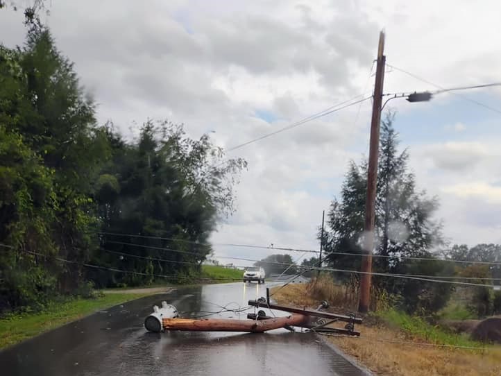
Snapped Power Pole on Sam Parker Road (Knox County) (Courtesy of Kimberly Hensley Ledford) |
Large Hail near Alpine (Whitley County) (Courtesy of Dylan Mcvicker) |
Radar
 |
|
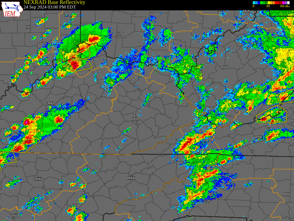
Regional Radar Imagery Loop 3 PM EDT September 24th, 2024 to 9 PM EDT, September 24th, 2024 |
Storm Reports
..TIME...   ...EVENT...      ...CITY LOCATION...     ...LAT.LON...
..DATE...   ....MAG....      ..COUNTY LOCATION..ST.. ...SOURCE....
            ..REMARKS..

0520 PM     Tstm Wnd Dmg     Spruce Pine             36.92N 83.45W
09/24/2024                   Leslie             KY   Emergency Mngr

            Trees and powerlines were down in the Spruce
            Pine and Saylor communities of southwestern
            Leslie county or in the general vicinity of
            the intersection of KY 1780 and KY 2058.

0522 PM     Tstm Wnd Dmg     1 NNW Susie             36.79N 84.96W
09/24/2024                   Wayne              KY   911 Call Center

            Wayne County dispatch reported a tree blown
            down onto KY-834 West approximately a mile
            north of the intersection with KY-90.

0525 PM     Tstm Wnd Dmg     2 NE Gray               36.96N 83.99W
09/24/2024                   Knox               KY   Public

            Social media post of a snapped power pole
            along Sam Parker Road in Knox County. Time
            estimated via radar. Approximately
            (36.96296, -83.98730).

0525 PM     Tstm Wnd Dmg     1 SSE Sand Springs      37.29N 84.35W
09/24/2024                   Rockcastle         KY   911 Call Center

            Rockcastle County 911 Center reported a down
            tree at the intersection of Marler Hollow Rd
            and Sand Springs Rd. Time estimated from
            radar.

0531 PM     Tstm Wnd Dmg     1 SE Pine Hill          37.32N 84.25W
09/24/2024                   Rockcastle         KY   911 Call Center

            Rockcastle County 911 Center reported a tree
            down at the intersection of US 25 and Upper
            Calloway Loop. Time estimated from radar.

0545 PM     Hail             Cane Creek              37.06N 83.92W
09/24/2024  M1.00 Inch       Laurel             KY   Public

            A public social media reported of quarter
            sized hail relayed by Amateur Radio.

0555 PM     Tstm Wnd Dmg     1 S Bradshaw            37.41N 83.96W
09/24/2024                   Jackson            KY   911 Call Center

            Jackson County dispatch reported a tree
            blown down across McCammon Ridge Road near
            the intersection with Kim Gay Lane. Event
            time estimated from radar.

0600 PM     Tstm Wnd Dmg     Alpine                  36.92N 84.52W
09/24/2024                   Pulaski            KY   911 Call Center

            A tree was blown down near the intersection
            of US 27 and Jeru Knob Road.

0605 PM     Hail             Grace                   37.20N 83.87W
09/24/2024  E1.50 Inch       Clay               KY   Public

            Social media picture of estimated 1.5 inch
            hail in Fogertown (37.200042, -83.869560).
            Time via radar.

0611 PM     Hail             1 NW Treadway           37.24N 83.79W
09/24/2024  E2.00 Inch       Clay               KY   Public

            A social media report with a picture was
            relayed by broadcast media of hail of 2 to
            2.25 inches in diameter.

0611 PM     Hail             Treadway                37.24N 83.79W
09/24/2024  E2.00 Inch       Clay               KY   Public

            Picture on social media of about 2 inch wide
            hailstones along Laurel Heights Road. Time
            estimated via radar (37.235433, -83.789241).

0612 PM     Hail             1 SW Burning Springs    37.24N 83.81W
09/24/2024  E2.00 Inch       Clay               KY   Public

            A picture was received via social media of
            hail of at least egg size near Burning
            Springs.

0612 PM     Hail             Alpine                  36.92N 84.52W
09/24/2024  E1.75 Inch       Pulaski            KY   Public

            Photo on social media of golf ball sized
            hail in Alpine.

0628 PM     Hail             Bark Camp               36.91N 84.25W
09/24/2024  E3.00 Inch       Whitley            KY   Public

            A picture was received of at least 3 inch
            diameter hail from the Bee Creek community
            along KY 1193 in the vicinity of Bark Camp.
            The event time is radar estimated.

0630 PM     Hail             1 ESE Bark Camp         36.90N 84.24W
09/24/2024  M2.00 Inch       Whitley            KY   Public

            A public report with a picture was relayed
            by an Amateur radio operator in the Bee
            Creek community southeast of Bark Camp. The
            event time is radar estimated.

0631 PM     Tstm Wnd Dmg     2 ESE Rye               36.92N 84.16W
09/24/2024                   Whitley            KY   Public

            Social media report of trees down on power
            lines and a broken power pole. Time
            estimated via radar.

0636 PM     Tstm Wnd Dmg     1 WNW Ricetown          37.40N 83.64W
09/24/2024                   Owsley             KY   Dept of Highways

            A tree was blown down onto Lower Wolfe Creek
            Road about 7 miles from the outskirts of
            Booneville or between Eddie Marshall Ln and
            KY 2024. The event time is radar estimated.

0636 PM     Hail             2 SSE Rye               36.90N 84.17W
09/24/2024  E1.25 Inch       Whitley            KY   Public

            A picture of hail was received from
            southwest of Corbin along Cumberland Falls
            Hwy. The event time is radar estimated.

0640 PM     Hail             North Corbin            36.96N 84.09W
09/24/2024  E1.00 Inch       Laurel             KY   Public

            Video on social media of quarter-sized hail
            falling behind the KFC in North Corbin. Time
            estimated via radar.

0648 PM     Hail             1 SE Barton             36.92N 84.12W
09/24/2024  E1.50 Inch       Whitley            KY   Public

            Ping Pong hail that then turned to pea sized
            hail was reported at the Baptist Hospital in
            Corbin.

0650 PM     Hail             Gray                    36.94N 84.01W
09/24/2024  E1.75 Inch       Knox               KY   911 Call Center


0710 PM     Hail             Woollum                 37.02N 83.82W
09/24/2024  E1.25 Inch       Knox               KY   Public

            Hail fell along KY 11 near the Clay County
            border and was estimated to be between
            quarter and golf ball sized.
Environment
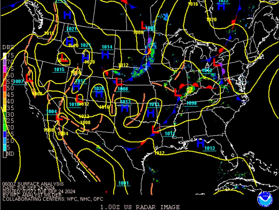
A low pressure system ahead of a deep upper level trough over the Central Plains slowly lifted from the Mid-Mississippi Valley to the Great Lakes leading up to and during the severe weather event as shown in Figure 1. The combination of lifting from an upper level disturbance rotating around the trough initiated scattered convective development late in the afternoon/evening within the warm sector's unstable and highly sheared atmosphere. Effective shear of around 50 knots and 1,000 to 2,000 J/kg of MLCAPE provided a sufficiently balanced environment for supercells. Additionally, long straight hodographs evident from atmospheric soundings were favorable for large hail producing updrafts. The end result of this combination of factors is shown in the MRMS Hail Swaths (Figure 2). Almost all of the large hail reports came from the supercell storm that tracked from WSW to ENE from northern Clinton County to northern Knox County and the other supercell which tracked SW to NE from northern Scott County, Tennessee to southern Owsley County.
 |
 |
| Figure 1: 2 AM EDT, September 24th through 2 AM EDT, September 25th, 2024 | Figure 2: Hail Swaths with Estimated Diameter |
 |
Media use of NWS Web News Stories is encouraged! Please acknowledge the NWS as the source of any news information accessed from this site. |
|

