
Isolated severe thunderstorms are likely across parts of the Southeast/Deep South Tuesday morning into early evening. A couple tornadoes are possible in parts of eastern Mississippi and Alabama. In the north-central U.S., a storm will bring heavy snow and gusty to high winds over parts of the northern Plains and Upper Midwest Tuesday before impacting the Great Lakes Wednesday into Thanksgiving. Read More >
Overview
|
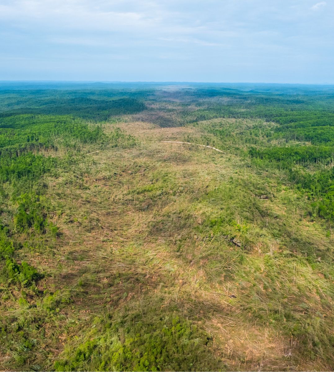
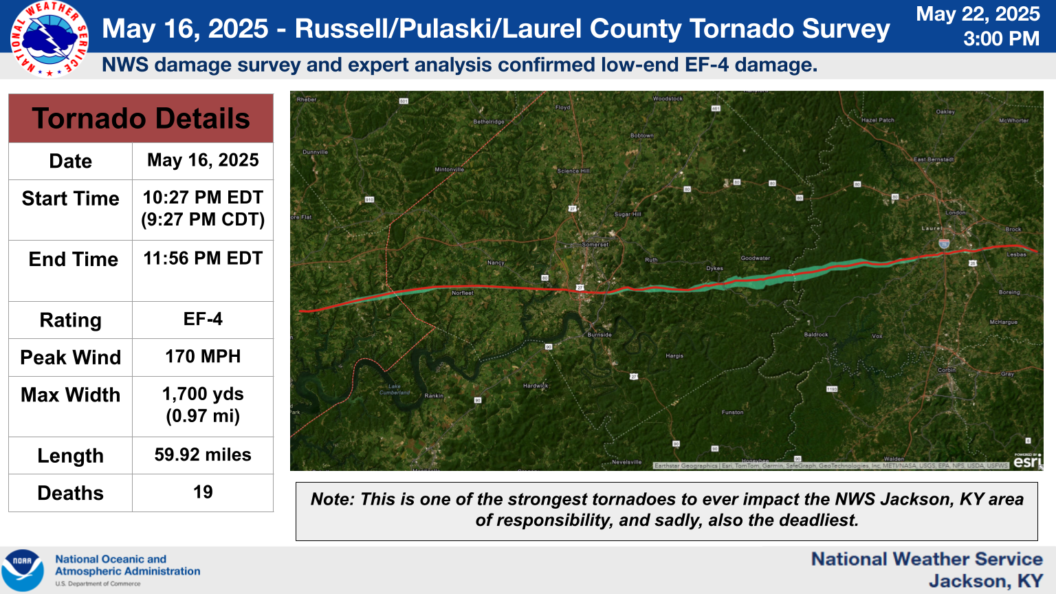
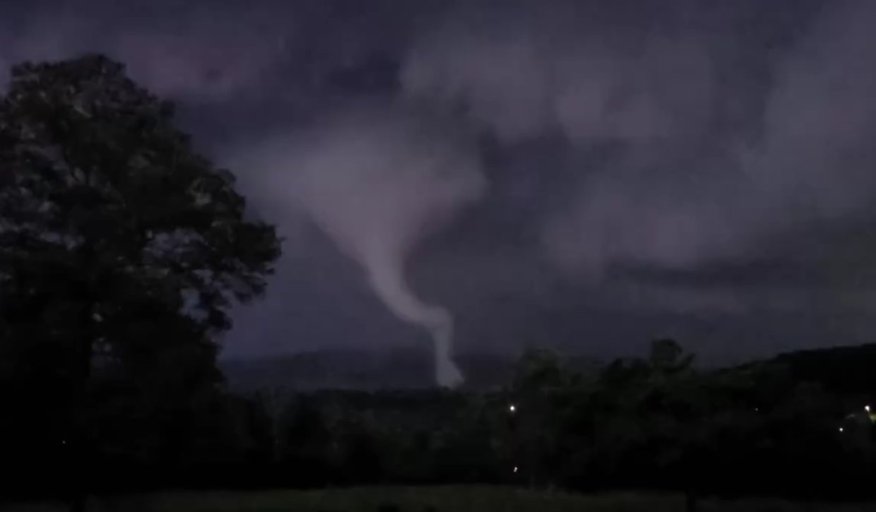
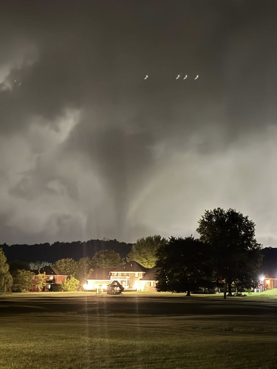
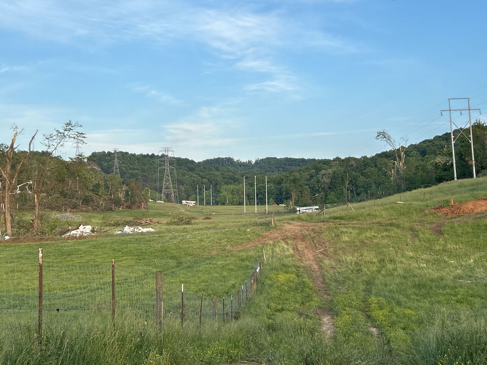
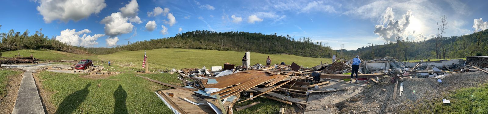
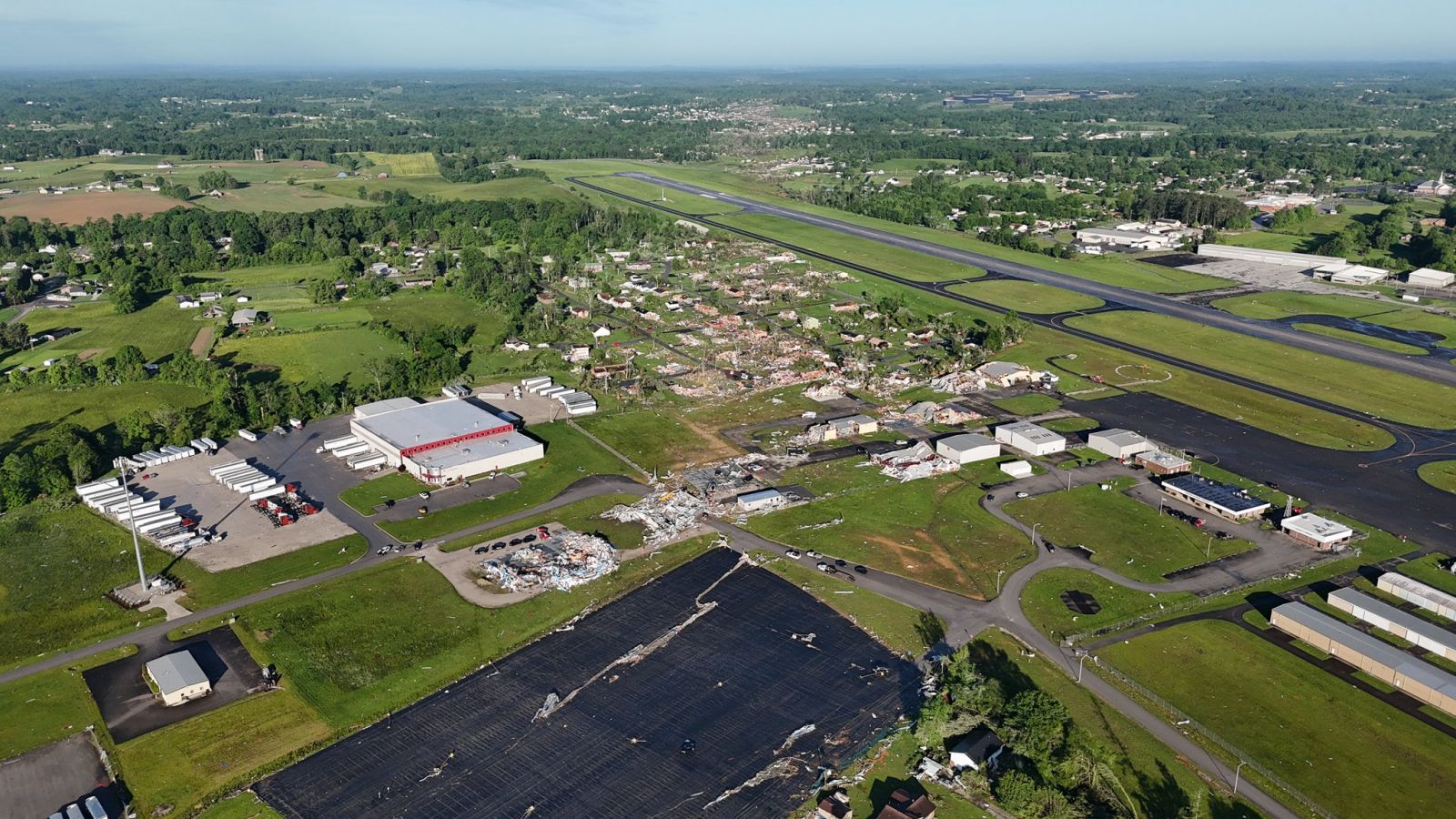
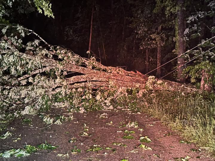
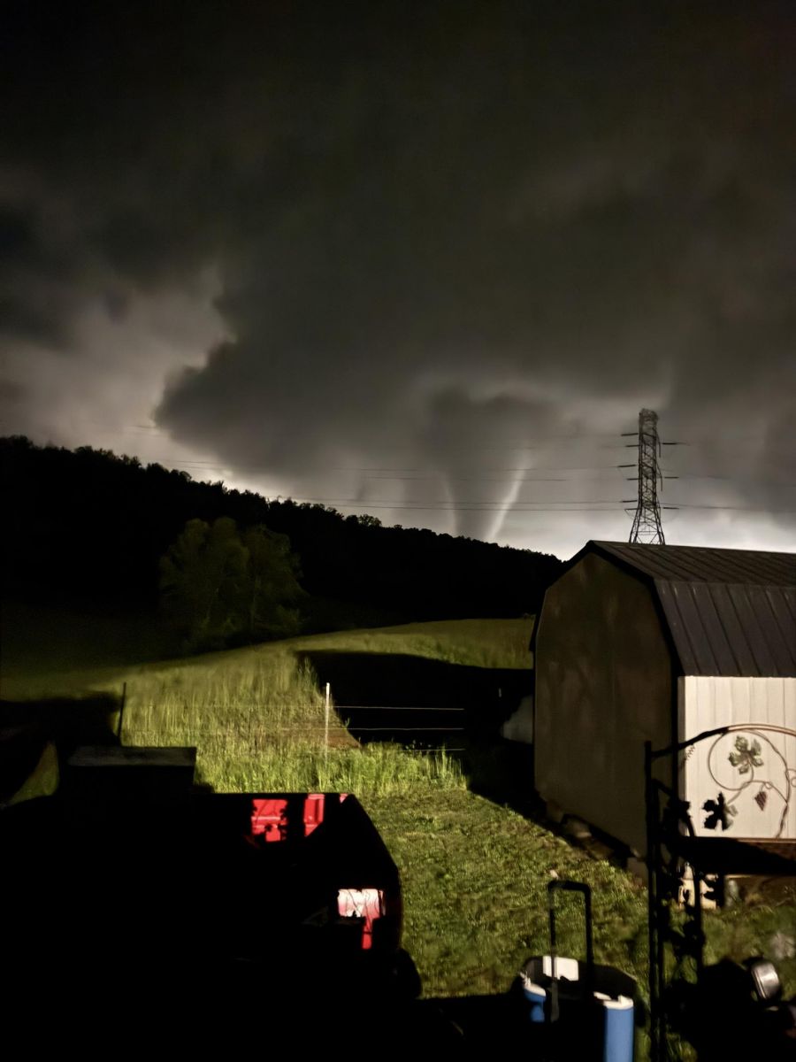
Eastern Kentucky experienced multiple rounds of severe weather from May 16th into the early morning hours of May 17th. The initial round of severe weather, occurring during the morning and early afternoon, produced swaths of large to significant hail (approaching baseball size), localized damaging winds, and heavy rainfall. Notably, intense thunderstorm wind gusts impacted downtown London, tearing a roof off the Wedding Shoppe and a portion of the Copper Penny, which subsequently landed on vehicles in a nearby parking area. A lull in storm activity from mid-afternoon through early evening allowed the atmosphere to become highly unstable. Scattered supercell thunderstorms then moved in from the west through the evening, generating multiple brief but strong to violent tornadoes across parts of eastern Missouri, southern Illinois, southern Indiana, and western Kentucky. A particularly long-lived supercell tracked east from the Ozarks of southern Missouri, intermittently producing brief tornadoes and wind damage as it moved through the southern portions of Western and Central Kentucky. The storm's final, and most destructive, tornado touched down in Russell County, approximately 4 miles southeast of Russell Springs. Initially, the damage path was fairly narrow, in the EF-2 to low EF-3 range, as it tracked through southeast Russell County and into Pulaski County, causing significant damage to structures and trees. After impacting the southern end of Somerset, inflicting considerable damage on residential homes and the Southern Kentucky RECC headquarters, the tornado strengthened and widened. It reached EF-4 strength with estimated winds of around 170 mph as it moved toward Mount Victory. The tornado's path of devastation continued eastward through the rugged and forested terrain of the Daniel Boone National Forest, reaching a maximum width of 1,700 yards. Radar indicated that debris was lofted at least 27,000 feet above the ground. The tornado narrowed again as it approached and crossed I-75, scouring neighborhoods south of downtown London and impacting the London-Corbin Airport, before lifting about 6 miles southeast of London. The most extensive residential damage and the largest number of casualties occurred in the Sunshine Hill community, just southwest of the London city limits. Official reports confirm 19 fatalities from this tornado, making it the deadliest tornado in the history of NWS Jackson. Seventeen of these deaths occurred in Laurel County, with one fatality each in Pulaski and Russell counties. At least 11 individuals sustained serious injuries, and an unknown number sustained less serious injuries. CHI St. Joseph Hospital in London reported treating 108 patients for injuries after the tornado. In Laurel County alone, the London mayor reported 817 homes affected, including 280 completely destroyed and 195 sustaining major damage. (For more detail, see the Official NWS Storm Survey summary and the NWS Damage Assessment Toolkit Viewer.) Following the tornado's dissipation, the parent supercell gradually weakened as it moved eastward through Clay, Leslie, Perry, and Letcher counties, producing substantial wind damage. Separately, another strong supercell tracked from the Bluegrass region into Rowan and Elliott counties, but fortunately caused only sporadic wind damage and up to egg-sized hail. Behind these supercells, additional intense thunderstorms accompanied the passage of a cold front, primarily producing strong to damaging straight-line wind gusts. Beyond the thunderstorms, the initial round of heavy rainfall early in the day occurred along a west-southwest to east-northeast axis, roughly from Rockcastle to Pike counties. Excessive rainfall, exceeding 3 inches in parts of Breathitt County, led to localized flash flooding. Additional isolated flash flooding occurred with the second round of thunderstorms late on May 16th and into the early morning hours of May 17th. The cumulative effect of the heavy rainfall resulted in high water at multiple river forecast points, including the South Fork Kentucky River at Oneida and Booneville, the Licking River at Salyersville, and the Levisa Fork at Prestonsburg. Minor flood stage was also exceeded at Heidelberg and Ravenna along the main stem of the Kentucky River. |
Top Picture: Destructive Tornado Approaching Rush Branch Road (Pulaski County) Bottom Picture: Tornado Destruction in the Sunshine Hills Community (Laurel County) |
 |
 |
 |
| Tornado Damage Redeemer Lutheran Church, Somerset (Pulaski County) (NWS Storm Survey) |
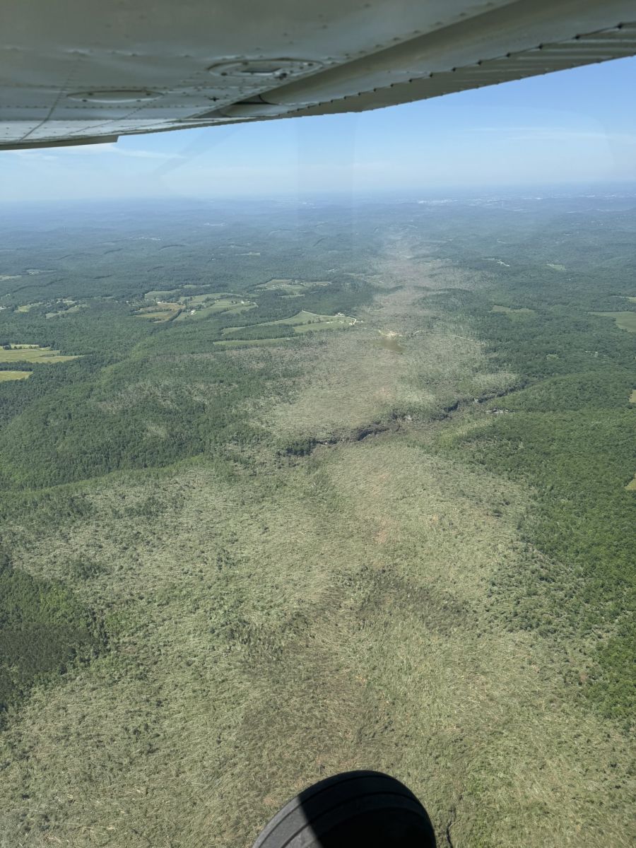
Tornado Path Through the Daniel Boone National Forest (Laurel County) (Courtesy of Ben Childers) |
Tornado-damaged Helicopter at London-Corbin Airport (Laurel County) (Courtesy of Mayor Randall Weddle) |
 |
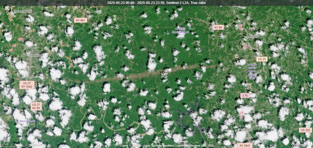 |
| Tornado Swath Easily Visible from Space between Somerset and London (Laurel and Pulaski Counties) (Courtesy of European Union, contains modified Copernicus Sentinel 2 Data) |
Tornadoes
Select a tornado from the table to zoom into the track and view more information. The default table view is limited to 8 tracks, but can be scrolled by a mouse wheel or dynamically expanded. Additionally, the table can fill the entire window by clicking the small circular expanding arrow icon at the very top right of the table and returned to its original size by clicking the button again. The side information panel that opens over the map can be closed using the "X" on the upper right corner of the pop-up. Zoom into the map and click damage points to see detailed information and pictures from the surveys.
|
NOTE: Times shown below are local to your device's time zone. Also, data may be slow to load when zooming in or out. |

The Enhanced Fujita (EF) Scale classifies tornadoes into the following categories:
| EF0 Weak 65-85 mph |
EF1 Moderate 86-110 mph |
EF2 Significant 111-135 mph |
EF3 Severe 136-165 mph |
EF4 Extreme 166-200 mph |
EF5 Catastrophic 200+ mph |
 |
|||||
| Tornadoes that fail to impact any ratable structures on the EF-Scale are rated EF-Unknown (EF-U) | |||||
|
Long path of destruction cut by tornado across Russell, Pulaski, and Laurel counties to I-75 |
|
Tornado Video from near Nancy, Kentucky |
Daniel Boone National Forest Tornado Damage Drone Video |
Security Video Clips From the London-Corbin Airport (Tornado Passes By Security Camera Between 2:30 and 3:59) |
Tornado Video near Somerset, Kentucky |
 |
 |
 |
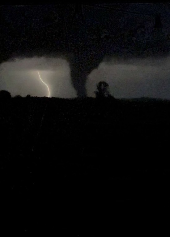
| Tornado in Pulaski County near Nancy (Courtesy of Jodie McClendon Wilson) |
Tornado in Pulaski County (Courtesy of Sean Lykins) |
Tornado in Laurel County (Courtesy of Alex Carter) |
 |
 |
 |
| Southern Kentucky RECC Building Damage (Pulaski County) (Courtesy of NWS Storm Survey) |
Southern Kentucky RECC Building Damage in Somerset (Pulaski County) (Courtesy of Kentucky Electric Cooperatives) |
High-Tension Power Line Tower Twisted and Thrown 250 yards Along Rush Branch Road (Pulaski County) (Courtesy of NWS Storm Survey) |
 |
| EF-4 Destruction to Farmhouse and Outbuildings along Poplarville Branch Road near the Time of the Tornadoes Peak Intensity and Width (Pulaski County) (Courtesy of Jane Marie Wix) |
 |
 |
 |
 |
 |
| Tornado Damage near KY-1003 (Pulaski County) (Courtesy of Johnnie Nicholson) |
Residential Damage along KY-1003 (Pulaski County) (Courtesy NWS Storm Survey) |
Swath of Destruction in the Daniel Boone National Forest (Courtesy of SR Radar) |
Trees Delimbed and Debarked East of Poplarville Branch Road (Pulaski County) (Courtesy of Michelle M) |
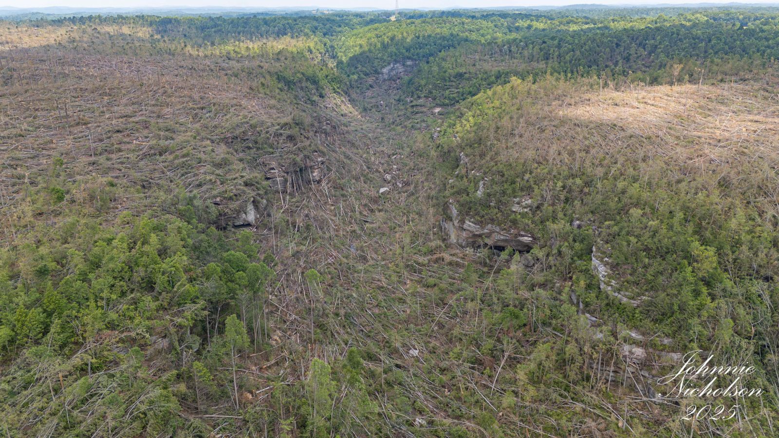
Tornado Damage Swath Crossing the Rockcastle River (Pulaski/Laurel County) (Courtesy of Johnnie Nicholson) |
 |
 |
| Tornado Damage Swath over the Rockcastle River (Pulaski/Laurel County) (Courtesy of Johnnie Nicholson) |
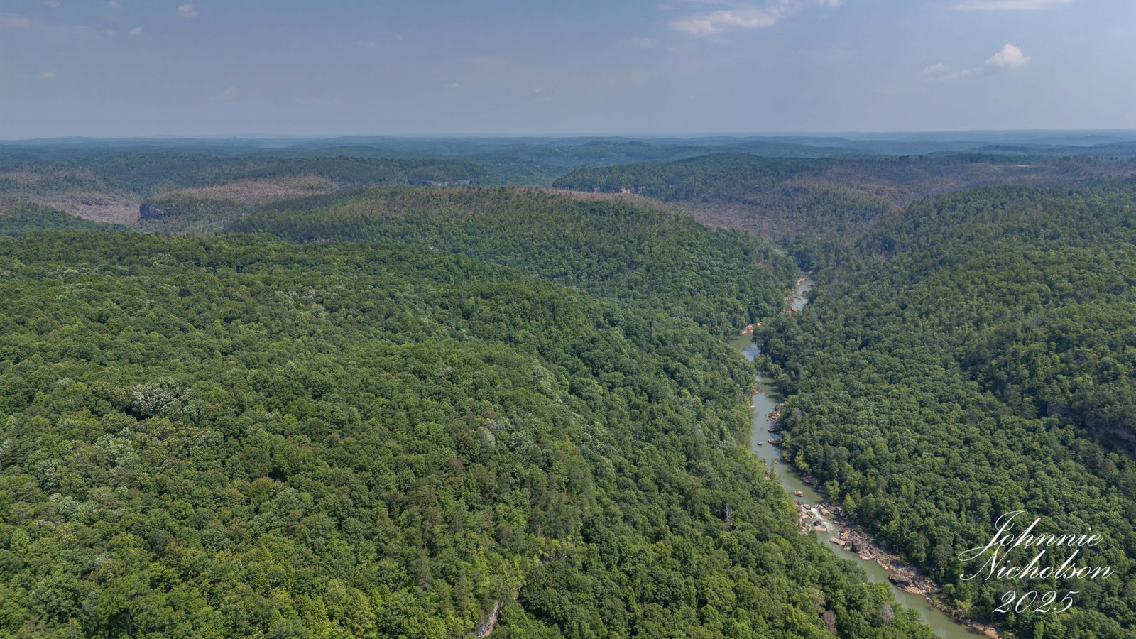
Tornado Damage Deep in the Rockcastle River Gorge (Pulaski/Laurel County) (Courtesy of Johnnie Nicholson) |
 |
 |
 |
| Sunshine Hill Baptist Church Razed to Concrete Walls (Laurel County) (Courtesy of NWS Storm Survey) |
Metal Frame from Trailer Home Wrapped around a Tree (Laurel County) (Courtesy of NWS Storm Survey) |
Concrete Porched Lifted and Displaced Several Feet (Laurel County) (Courtesy of NWS Storm Survey) |
 |
 |
 |
 |
| EF-4 Destruction in the Sunshine Hills Community (Laurel County) (Courtesy of NWS Storm Survey) |
Home Swept Clean from Foundation in Sunshine Hills (Laurel County) (Courtesy of NWS Storm Survey) |
Concrete Slab Swept Clean, Lifted, and Moved in Sunshine Hills (Laurel County) (Courtesy of NWS Storm Survey) |
Lumber Impaled into Roof in Sunshine Hills (Laurel County) (Courtesy of NWS Storm Survey) |
 |
 |
 |
 |
| Tornado Track Through the London-Corbin Airport (Laurel County) (Courtesy of Johnnie Nicholson) |
Destruction on Miller Lane South of the London-Corbin Airport (Laurel County) (Courtesy of NWS Storm Survey) |
Home Damage along Cedar Ridge Road Southeast of London (Laurel County) (Courtesy of NWS Storm Survey) |
One of Multiple Airplanes Crushed in Collapsed Hangar at London-Corbin Airport (Laurel County) (Courtesy of Joseph Ricciotti) |
Wind, Hail, and Flash Flooding
 |
 |
 |
 |
| Straight-line Winds Blew off Roof in London(Laurel County) (Courtesy of Johnnie Nicholson) |
Tree Blown Down in Dema (Knott County) (Courtesy of John Hicks) |
One of Many Trees Blown Down in the vicinity of Watson Ridge (Estill County) (Courtesy of Mills Creek Fire Rescue) |
Wind Damage near Hazel Green (Wolfe County) (Courtesy of Shane Williams) |
 |
 |
 |
| Significant Hail at Ned (Perry County) (Courtesy of Johnny Ray Feltner) |
Significant Hail at Lost Creek (Breathitt/Perry County line) (Courtesy of Anna Jones) |
Large Hail at Rowdy (Perry County) (Courtesy of Anthony Campbell) |
 |
 |
 |
| Significant Hail at McKee (Jackson County) (Courtesy of Kellie Brockman) |
Significant Hail at Morehead (Rowan County) (Courtesy of Joshua McCoy) |
Another Significant Hailstone at Morehead (Rowan County) (Courtesy of Music Lover) |
|
Rapid Onset Flooding at intersection of Whick Lick Branch Road and Bowling Road |
Storm Reports
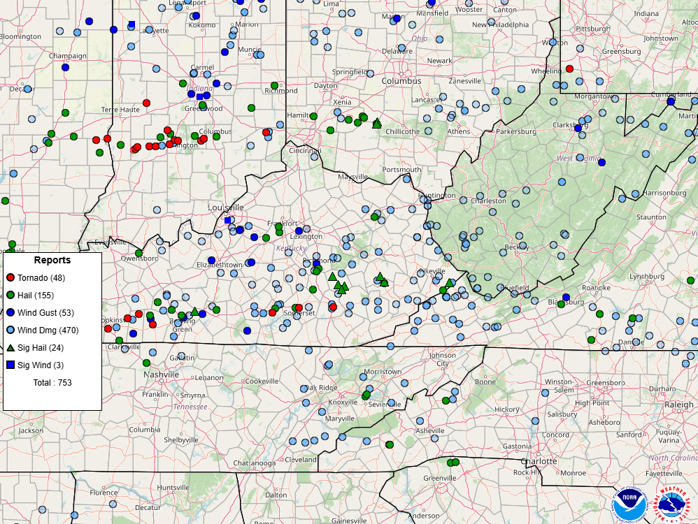
Map of local Storm Reports, courtesy of the Storm Prediction Center.
..TIME... ...EVENT... ...CITY LOCATION... ...LAT.LON...
..DATE... ....MAG.... ..COUNTY LOCATION..ST.. ...SOURCE....
..REMARKS..
0944 AM Hail Tyner 37.35N 83.90W
05/16/2025 M2.00 Inch Jackson KY Public
Social media photos of estimated 2 to 3 inch
diameter hail from the Tyner Lake area of
Jackson County.
1000 AM Hail 1 WSW Atkinstown 37.37N 83.99W
05/16/2025 E2.00 Inch Jackson KY Public
Hail up to approximately egg size was
reported along KY-290 between Annville and
McKee. Event time estimated from radar.
1048 AM Tstm Wnd Dmg 1 E Lucky Stop 37.96N 83.80W
05/16/2025 Montgomery KY 911 Call Center
Tree blown into the power lines near the
intersection of Rocky Branch Road and Main
Street. Event time estimated from radar.
1048 AM Tstm Wnd Dmg 1 ENE Ewington 38.09N 83.87W
05/16/2025 Montgomery KY 911 Call Center
Two trees blown down along Turkey Road near
the intersection with Stepstone Road.
1053 AM Hail 2 S Ned 37.39N 83.27W
05/16/2025 E1.00 Inch Perry KY Public
Nickel to quarter-sized hail observed at the
Wendell H Ford Airport.
1058 AM Hail 1 SW Rowdy 37.41N 83.22W
05/16/2025 E1.75 Inch Perry KY Emergency Mngr
Emergency Manager reported golf ball-sized
hail along Noble Branch.
1058 AM Hail 1 NE Ned 37.42N 83.27W
05/16/2025 E2.00 Inch Breathitt KY Public
Photo shared via social media of multiple
hail stones of at least 2 inch diameter.
1100 AM Hail Ned 37.41N 83.27W
05/16/2025 M2.00 Inch Breathitt KY Public
Photo via social media of 2.00 to 2.50-inch
diameter hail. Time estimated from radar.
1142 AM Hail Wabo 37.31N 84.39W
05/16/2025 E1.00 Inch Rockcastle KY Public
Picture on social media shows approximately
quarter-sized hail near Wabd. Time of
occurrence estimated from radar.
1157 AM Tstm Wnd Dmg Blue Moon 37.51N 82.70W
05/16/2025 Floyd KY 911 Call Center
County dispatch reported a tree blown down
and partially blocking KY-2030.
1202 PM Hail 1 NE Collingsworth 37.48N 84.08W
05/16/2025 E2.00 Inch Jackson KY Public
Picture on social media showed approximately
egg-size hail. Time of occurrence estimated
from radar.
1215 PM Hail 1 SW Elkhorn City 37.30N 82.35W
05/16/2025 M1.25 Inch Pike KY Trained Spotter
Hail fell from 12:15 to 12:20 PM. Photo
provided to the office.
1242 PM Hail 1 SW Demo 37.40N 82.79W
05/16/2025 E0.75 Inch Knott KY Public
Report from mPING: Dime (0.75 in.).
1246 PM Tstm Wnd Dmg 1 W Bronston 36.98N 84.64W
05/16/2025 Pulaski KY 911 Call Center
Tree blocking road near 200 Old Bronston
School Road.
1248 PM Tstm Wnd Dmg Steubenville 36.89N 84.80W
05/16/2025 Wayne KY 911 Call Center
Trees and power lines down along KY Highway
3106 and KY Highway 1275 N between
Monticello and Steubenville. Exact location
estimated.
1249 PM Tstm Wnd Dmg 1 NE Grade 37.09N 84.45W
05/16/2025 Pulaski KY 911 Call Center
Tree down on road.
1249 PM Tstm Wnd Dmg 1 ESE Grade 37.07N 84.45W
05/16/2025 Pulaski KY 911 Call Center
Several trees down blocking Close Road.
1251 PM Tstm Wnd Dmg 2 SW Grade 37.06N 84.49W
05/16/2025 Pulaski KY 911 Call Center
Couple of trees down blocking the road near
the intersection of Clay Hill Road and
Kettlehead Road.
0101 PM Hail 1 SW Welchburg 37.31N 83.94W
05/16/2025 M2.00 Inch Jackson KY Public
Time of occurrence estimated from radar.
0103 PM Hail Lost Creek 37.48N 83.33W
05/16/2025 E2.75 Inch Breathitt KY Public
Photos of two hailstones with diameter
greater than 2 inches. Largest stone appears
to be 2.75 inches or larger.
0103 PM Tstm Wnd Dmg 1 SSW London 37.12N 84.09W
05/16/2025 Laurel KY Public
Multiple photos of large tree snapped and
split three ways and blocking the
intersection of Whitley Street and Jody
Street in London. Power pole snapped and
power lines down due to snapped tree.
0103 PM Tstm Wnd Dmg 1 NW London 37.13N 84.09W
05/16/2025 Laurel KY 911 Call Center
Roof peeled off a business onto multiple
adjacent vehicles. Vehicles have sustained
unspecified damage.
0105 PM Hail 2 ESE Garden Village 37.41N 82.44W
05/16/2025 E0.88 Inch Pike KY Fire Dept/Rescue
Passed along via the Pike County EM.
0107 PM Tstm Wnd Dmg 1 SE London 37.11N 84.07W
05/16/2025 Laurel KY Trained Spotter
A spotter in southeast London noted that
trees were downed along Barrett Road as the
storms moved through. Time estimated by
radar.
0108 PM Tstm Wnd Dmg 2 NNW Levi Jackson Wild 37.10N 84.05W
05/16/2025 Laurel KY 911 Call Center
A couple of trees down near the intersection
of Sasser School Road and Shields Lane.
0108 PM Tstm Wnd Dmg 1 SSE Moores Creek 37.26N 83.99W
05/16/2025 Jackson KY 911 Call Center
Tree down and blocking Moores Creek School
Road. Time estimated from radar.
0109 PM Tstm Wnd Dmg 1 W Brock 37.11N 84.02W
05/16/2025 Laurel KY Public
Trees were reported to have been blown down
near Bush Elementary School along KY 80 in
eastern Laurel County with a picture relayed
by a Ham radio operator. The event time is
radar estimated.
0112 PM Hail Fedscreek 37.40N 82.25W
05/16/2025 M2.00 Inch Pike KY Emergency Mngr
Report via the Pike County EM.
0116 PM Tstm Wnd Dmg Pigeonroost 37.11N 83.81W
05/16/2025 Clay KY 911 Call Center
Several trees down in the Curry Branch Rd
and KY Highway 80 area.
0118 PM Tstm Wnd Dmg 1 SSW London-Corbin Air 37.07N 84.09W
05/16/2025 Laurel KY 911 Call Center
A couple of trees down in the Sublimity
Springs Subdivision.
0120 PM Tstm Wnd Dmg 1 SW Barcreek 37.22N 83.65W
05/16/2025 Clay KY 911 Call Center
Multiple trees down along Bar Creek Rd. Time
estimated from radar.
0120 PM Tstm Wnd Dmg 1 WSW Garden Village 37.41N 82.48W
05/16/2025 Pike KY Emergency Mngr
Trees down between the 400 and 500 block of
Lick Branch Road.
0121 PM Tstm Wnd Dmg Garden Village 37.42N 82.46W
05/16/2025 Pike KY Emergency Mngr
Trees down on East Shelbiana Road between
Petyon Creek and Greesy Creek Road.
0123 PM Tstm Wnd Dmg Haven 37.01N 83.83W
05/16/2025 Knox KY 911 Call Center
Tree down on power line. Time estimated from
radar. Possible that damage was caused by
subsequent storm about 30 minutes later.
0126 PM Tstm Wnd Dmg Whick 37.42N 83.38W
05/16/2025 Breathitt KY Public
In or near Whick along KY 1110 trees and
powerlines were reported to have been blown
down. The event time is radar estimated.
0126 PM Tstm Wnd Dmg 1 WNW Lipps 37.05N 83.68W
05/16/2025 Clay KY 911 Call Center
Several trees reported down in the Otter
Creek Rd and Goose Creek Rd areas.
0129 PM Tstm Wnd Dmg Big Creek 37.16N 83.57W
05/16/2025 Clay KY 911 Call Center
Trees down in the Big Creek area and power
line down on Hal Rogers Parkway near mile
marker 26.
0150 PM Tstm Wnd Dmg 2 NNE Frew 37.21N 83.23W
05/16/2025 Perry KY 911 Call Center
County dispatch reported a tree bringing
down power lines onto a residence in the
2600 block of Big Creek Road. Time of
occurrence estimated from radar.
0150 PM Hail 1 S Wooton 37.16N 83.30W
05/16/2025 E0.50 Inch Leslie KY Public
Report from mPING: Half-inch (0.50 in.).
0154 PM Tstm Wnd Dmg Cornettsville 37.13N 83.08W
05/16/2025 Perry KY Law Enforcement
State police reported a tree knocked down
onto KY-7 in the vicinity of Cornettsville.
Time of event occurrence estimated from
radar.
0158 PM Tstm Wnd Dmg 1 WNW Delphia 37.03N 83.11W
05/16/2025 Perry KY 911 Call Center
Power pole blown down, leaving power lines
on a residence and transformer on a driveway
in the 2000 block of KY-463. Time of
occurrence estimated from radar.
0200 PM Tstm Wnd Dmg Hyden 37.16N 83.37W
05/16/2025 Leslie KY 911 Call Center
At least ten reports of trees down with
power outages throughout the county and
impacting most major thoroughfares,
including US Highway 421 and KY Highway 80.
Radar estimates strong winds from around
1:30 PM to approximately 2:50 PM based on
radar.
0213 PM Tstm Wnd Dmg 2 WSW Coal Run 37.50N 82.59W
05/16/2025 Pike KY 911 Call Center
Pike County dispatch reported a tree blown
down and partially blocking Hurricane Road
in the 4400 block. Time of occurrence
estimated from radar.
0215 PM Tstm Wnd Dmg Millstone 37.17N 82.75W
05/16/2025 Letcher KY Law Enforcement
State police reported a tree blown down near
the Millstone community.
0217 PM Flood Dumont 37.53N 83.36W
05/16/2025 Breathitt KY Public
Photo of at least a foot or more of water
over Quicksand Rd at the Happy Church. KY
Transportation Cabinet trucks appear to be
manning both sides of the water to deter
vehicles from crossing.
0221 PM Tstm Wnd Dmg 2 ESE Raccoon 37.48N 82.41W
05/16/2025 Pike KY 911 Call Center
Pike County dispatch reported a tree blown
down and blocking Raccoon Road in the 6500
block. Road was closed. Time of occurrence
estimated from radar.
0222 PM Tstm Wnd Dmg Garden Village 37.42N 82.47W
05/16/2025 Pike KY 911 Call Center
Pike County dispatch reported a tree hanging
over and partially blocking East Shelbiana
Road in the 4000 block. Event occurrence
time estimated from radar.
0233 PM Tstm Wnd Dmg 3 E Fedscreek 37.40N 82.20W
05/16/2025 Pike KY 911 Call Center
Pike County dispatch reported a utility line
knocked down onto a roof and a power pole
blown over in the 3000 block of Fedscreek
Road. Time of occurrence estimated from
radar.
0300 PM Flood 1 NE Ned 37.42N 83.27W
05/16/2025 Breathitt KY Public
Photo shared via social media of small
stream flooding over a road in the
Cockerells Fork area of Ned.
0317 PM Flash Flood 1 SSW Saldee 37.44N 83.39W
05/16/2025 Breathitt KY Public
Video on social media shows flash flooding
at the intersection of Whick Lick Branch
Road and Bowling Road.
0409 PM Flash Flood 2 NE Handshoe 37.49N 82.89W
05/16/2025 Floyd KY Law Enforcement
Floyd County Sherriff reported flash
flooding over Salt Lick Road (KY-2029)
around the 700 block. Road impassable.
0946 PM Tstm Wnd Dmg 1 SSW Plummers Landing 38.31N 83.57W
05/16/2025 Fleming KY 911 Call Center
Trees blown down and blocking half of the
highway in the 15400 block of Morehead Road.
Event time estimated from radar.
0946 PM Tstm Wnd Dmg 3 NW Muses Mills 38.38N 83.56W
05/16/2025 Fleming KY 911 Call Center
Tree uprooted and hanging over the highway,
stuck in another tree, along the 4800 block
of Goddard Road.
0946 PM Tstm Wnd Dmg 1 ENE Ringos Mills 38.27N 83.59W
05/16/2025 Fleming KY 911 Call Center
Tree blown down and blocking Rawlins Road.
Event time estimated from radar.
0959 PM Tstm Wnd Dmg 2 NNW Gates 38.26N 83.38W
05/16/2025 Rowan KY 911 Call Center
Large tree reportedly blown down on Big
Perry Road in the 2200 block. Event time
estimated from radar.
1003 PM Tstm Wnd Dmg 1 NNW Fainville 37.71N 84.07W
05/16/2025 Estill KY Trained Spotter
Trained spotter called to report two trees
were down near the intersection of Majestic
Dr and CR-1446. Time estimated from radar.
1009 PM Tstm Wnd Dmg Pitts 37.71N 83.88W
05/16/2025 Estill KY Public
Pictures from social media show multiple
trees blown down on Tipton Ridge along
KY-52. Event time estimated from radar.
1029 PM Hail 1 NW Rodburn 38.21N 83.42W
05/16/2025 M1.00 Inch Rowan KY Public
Report from mPING: Quarter (1.00 in.).
1029 PM Tstm Wnd Dmg 1 NNW High Falls 37.75N 83.59W
05/16/2025 Wolfe KY NWS Employee
A tree was blown down along the east bound
lane of the Mountain Parkway between Pine
Ridge and Campton. Event time estimated from
radar.
1030 PM Hail 2 NNE Lakeview Heights 38.18N 83.50W
05/16/2025 M2.00 Inch Rowan KY Emergency Mngr
Lopsided hail measuring 2 inches in
diameter. Time is approximate and based on
radar.
1030 PM Tstm Wnd Gst 1 SW Munson 38.22N 83.48W
05/16/2025 M43 MPH Rowan KY Mesonet
Mesonet station MRHD Morehead 4 NE.
1033 PM Tstm Wnd Dmg 1 SSW Trent 37.76N 83.47W
05/16/2025 Wolfe KY NWS Employee
Corrects previous tstm wnd dmg report from 1
SSW Trent. At least 8 trees blown down along
KY-191 between Trent and Stillwater. Event
time estimated from radar.
1033 PM Tstm Wnd Dmg Wind Cave 37.51N 83.94W
05/16/2025 Jackson KY 911 Call Center
County dispatch reported at least a dozen
instances of a trees blown down around the
county, including along Wind Cave Road,
KY-89, and Ledger Fork Road. Some of the
trees took down power lines.
1035 PM Hail Morehead 38.19N 83.43W
05/16/2025 E1.75 Inch Rowan KY 911 Call Center
County dispatch reported up to golf
ball-sized hail in Morehead.
1038 PM Tstm Wnd Dmg 1 SE Daysboro 37.78N 83.36W
05/16/2025 Wolfe KY Public
Pictures on social media show multiple trees
blown down, including onto residence and
vehicles along Fallen Road. Minor wind
damage was also sustained to siding and
roofing of a single wide trailer.
1042 PM Tstm Wnd Dmg 2 SSW Vale 38.17N 83.31W
05/16/2025 Rowan KY 911 Call Center
Tree reported blown down along CCC Trail.
Event time estimated from radar.
1057 PM Tornado Somerset 37.08N 84.61W
05/16/2025 Pulaski KY Trained Spotter
Trained Spotter reported tornado in
Somerset.
1100 PM Hail 3 W Somerset 37.08N 84.66W
05/16/2025 E1.25 Inch Pulaski KY Trained Spotter
Report of half dollar size hail near mile
marker 2 on KY Route 914.
1100 PM Hail 1 N Somerset 37.10N 84.61W
05/16/2025 E1.75 Inch Pulaski KY Public
1109 PM Tstm Wnd Gst 1 N NWS Office/Julian C 37.60N 83.32W
05/16/2025 M41 MPH Breathitt KY ASOS
ASOS station KJKL NWS Jackson.
1118 PM Tstm Wnd Gst Koomer Ridge Camping Gr 37.78N 83.63W
05/16/2025 M48 MPH Wolfe KY Mesonet
Mesonet station KOMK2 Koomer Ridge RAWS.
1125 PM Tstm Wnd Dmg Add 37.91N 82.56W
05/16/2025 Martin KY Public
Tree blown down and partially blocking
Rockcastle Road near the intersection with
Abbs Lane. Event time estimated from radar.
1140 PM Tstm Wnd Dmg 2 W Bean 37.94N 83.87W
05/16/2025 Montgomery KY 911 Call Center
County dispatch reported a tree blocking
Willoughby Town Road near the intersection
of KY-213. Time of event occurrence
estimated from radar.
1147 PM Tornado London-Corbin Airport 37.09N 84.07W
05/16/2025 Laurel KY Broadcast Media
Likely tornado damage shown at the London
Airport.
1156 PM Tstm Wnd Gst 3 E Odds 37.75N 82.63W
05/16/2025 M40 MPH Martin KY Mesonet
Mesonet station BSAK2 Big Sandy RAWS.
1157 PM Tstm Wnd Dmg 1 SSE Weedon 37.70N 84.01W
05/16/2025 Estill KY Public
Picture on social media shows tree blown
down onto Stacy Lane Road. Event time
estimated from radar.
1202 AM Tstm Wnd Gst 2 S Rodburn 38.18N 83.41W
05/17/2025 M40 MPH Rowan KY Mesonet
Mesonet station TRMK2 Triangle Mtn RAWS.
1205 AM Tstm Wnd Dmg Stanton 37.85N 83.86W
05/17/2025 Powell KY NWS Employee
Multiple trees blown down in the vicinity of
Stanton. Event time estimated from radar.
1207 AM Tstm Wnd Dmg 1 NW Pryse 37.67N 83.90W
05/17/2025 Estill KY Fire Dept/Rescue
Millers Creek Fire Rescue clear out over 50
trees blown down into the local roadways.
1209 AM Tstm Wnd Dmg 2 SE Whynot 37.62N 83.77W
05/17/2025 Lee KY 911 Call Center
County dispatch reported that many
individual trees blown down around the
county, but provided no specific details.
1226 AM Tstm Wnd Dmg Parnell 36.87N 84.94W
05/17/2025 Wayne KY 911 Call Center
County dispatch reported multiple trees
blown down along KY-92 west of Monticello.
Event time estimated from radar and Kentucky
Mesonet station Monticello 4 NW.
1229 AM Tstm Wnd Gst 1 NNW Monticello 36.85N 84.85W
05/17/2025 M46 MPH Wayne KY AWOS
AWOS station KEKQ Monticello Apt.
1230 AM Tstm Wnd Gst 3 E Parnell 36.87N 84.90W
05/17/2025 M56 MPH Wayne KY Mesonet
Mesonet station MONT Monticello 4 NW.
1230 AM Tstm Wnd Gst 3 WNW Mill Springs 36.96N 84.83W
05/17/2025 M59 MPH Wayne KY Mesonet
Mesonet station FW1232 Monticello.
1230 AM Tstm Wnd Dmg 1 SSW Monticello 36.83N 84.86W
05/17/2025 Wayne KY 911 Call Center
Tree was blown down onto a mobile home and
involved electrical lines in the 500 block
of South Main Street. Event time estimated
from radar.
1231 AM Tstm Wnd Dmg 1 SSE Monticello 36.83N 84.84W
05/17/2025 Wayne KY 911 Call Center
Tree was blown down and blocked Michigan
Avenue adjacent to the Monticello Wayne
County Park. Event time estimated from
radar.
1240 AM Tstm Wnd Gst 1 SW Dabney 37.18N 84.56W
05/17/2025 M42 MPH Pulaski KY Mesonet
Mesonet station DABN Somerset 7 NNE.
1255 AM Tstm Wnd Dmg Pilgrim 37.80N 82.42W
05/17/2025 Martin KY 911 Call Center
Martin County dispatch reported over a dozen
instances of trees blown down onto or along
highways around the county. Some of the
trees involved power and phone lines. The
Pilgrim, Warfield, and Inez areas may have
had a larger concentration of the damage.
0101 AM Tstm Wnd Gst Somerset Pulaski County 37.05N 84.61W
05/17/2025 M48 MPH Pulaski KY Mesonet
Mesonet station SOMK2 Somerset RAWS.
0103 AM Tstm Wnd Dmg 2 SE Hoskinston 37.06N 83.37W
05/17/2025 Leslie KY Dept of Highways
Many trees were reported to have been blown
down along KY 2009 (Greasy Creek Road)
between about MM 12 and MM 14. The event
time is estimated from radar.
0107 AM Tstm Wnd Dmg 1 N Raven 37.42N 82.81W
05/17/2025 Floyd KY Law Enforcement
KY-7 closed by large tree blown down and
blocking both lanes. Power lines were knock
down. Event time estimated from radar.
0124 AM Tstm Wnd Dmg 1 E Isom 37.19N 82.89W
05/17/2025 Letcher KY 911 Call Center
County dispatch reported trees blown down in
many parts of the county but did not provide
specific details. KY-160 and KY-1103
apparently stood out as highways which saw a
greater number of trees down. Time
approximate.
0155 AM Tstm Wnd Gst 1 WNW Middlesboro 36.62N 83.73W
05/17/2025 M43 MPH Bell KY AWOS
AWOS station K1A6 Middlesboro Apt.
0155 AM Tstm Wnd Gst 1 WNW Big Black Mountai 36.92N 82.91W
05/17/2025 M54 MPH Harlan KY Mesonet
Mesonet station BMTN Harlan 24 E.
0207 AM Flash Flood Pikeville 37.48N 82.51W
05/17/2025 Pike KY Law Enforcement
Chloe Road was closed near Pikeville
Elementary School due to water over the
roadway.
0430 AM Tstm Wnd Gst 3 E Dorton 37.28N 82.52W
05/17/2025 M41 MPH Pike KY Mesonet
Mesonet station DORT Pikeville 13 S.
0935 AM Flood Stevenson 37.58N 83.27W
05/17/2025 Breathitt KY Fire Dept/Rescue
Water over the road at Bert Barnetts,
Meatscaffold, and Slate Branch along KY-30
East.
Environment
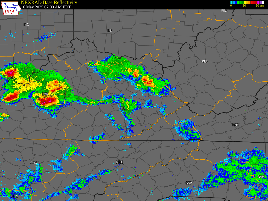
On the morning of May 16th, Eastern Kentucky was situated within the warm sector of a strong low-pressure system occluding over west-central Minnesota. The system's associated cold front swept out a large arc, extending north and east from the low in the Great Lakes, then south and west along the Lower Ohio River. Convection initiated within a moderately unstable and strongly sheared environment along the front over the Lower Ohio River, then rapidly propagated eastward ahead of the front toward the Central Appalachians. Inclement weather during this first round (Figure 2) was primarily characterized by large to significant hail, damaging wind gusts, and instances of flash flooding.
By evening, a triple-point low developed over the southern Great Lakes, accompanied by an intensifying low-level jet. The combination of sustained strong shear, renewed potent destabilization within a humid air mass (dewpoints near 70°F) following earlier convection, and increasing low-level directional shear created an exceptionally favorable environment for tornadic supercells. Several brief tornadoes occurred in this conducive environment across eastern Missouri, southern Illinois, western Kentucky, and southern Indiana. However, the most favorable conditions for strong to violent tornadoes converged over south-central Kentucky between 10 PM EDT on the 16th and 12 AM EDT on the 17th, coinciding with a discrete supercell preceding a consolidating line of thunderstorms moving across the Commonwealth (Figure 3).
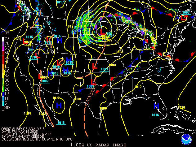 |
| Figure 1: Surface Analysis and Radar from 5 AM EDT (0900Z), May 16th to 8 AM EDT (1200Z), May 17th |
 |
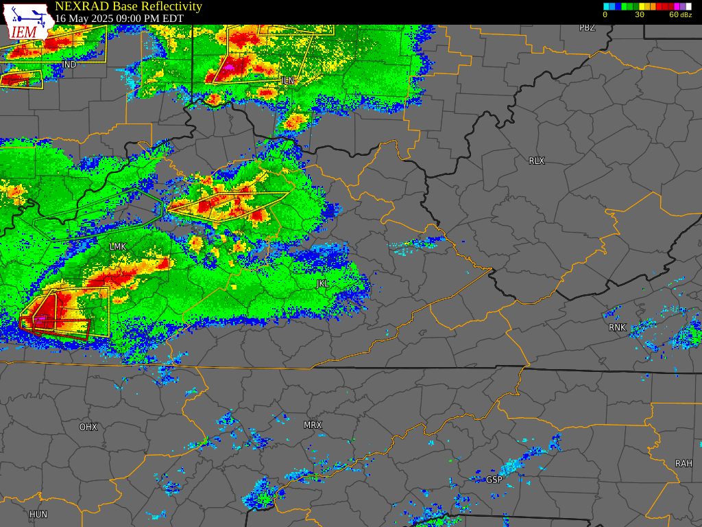 |
| Figure 2: 7 AM EDT, May 16th to 3 PM EDT, May 16th, 2025 (Courtesy of Iowa State University) |
Figure 3: 9 PM EDT, May 16th to 5 AM EDT, May 17th, 2025 (Courtesy of Iowa State University) |
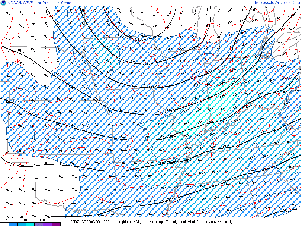
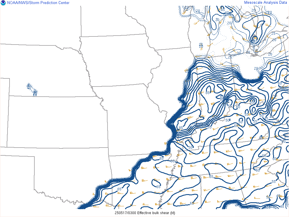
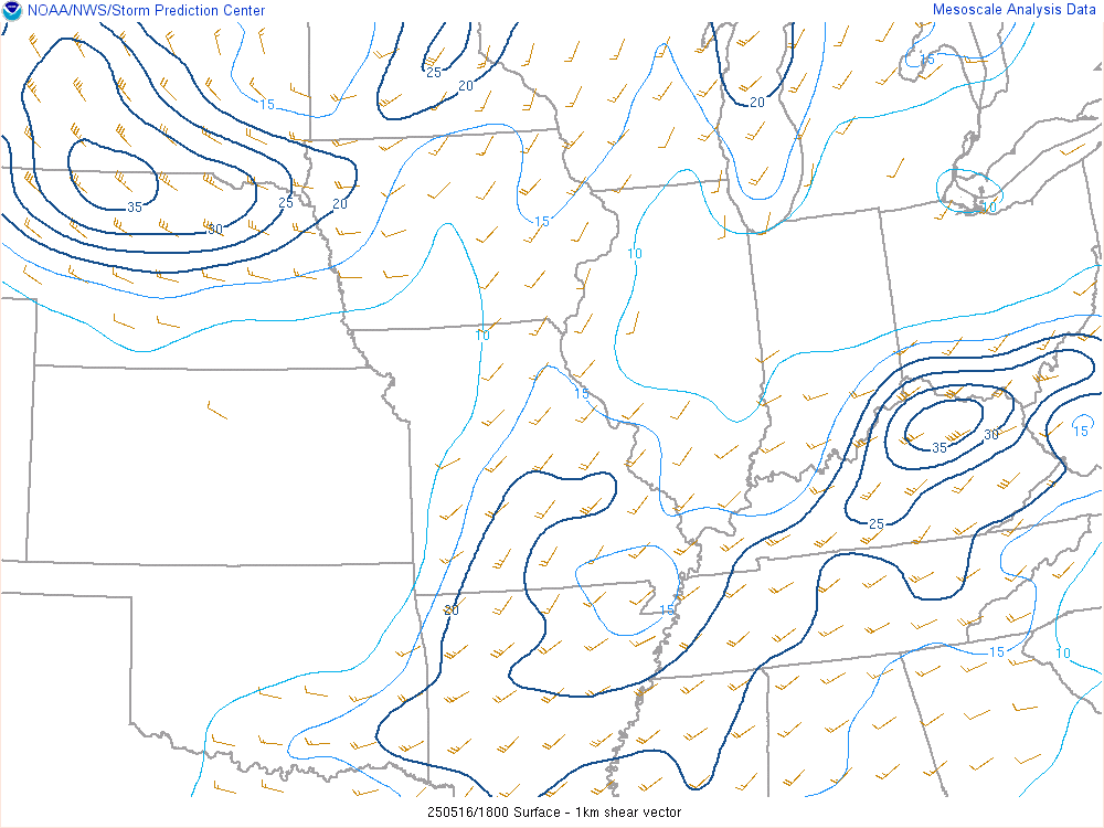
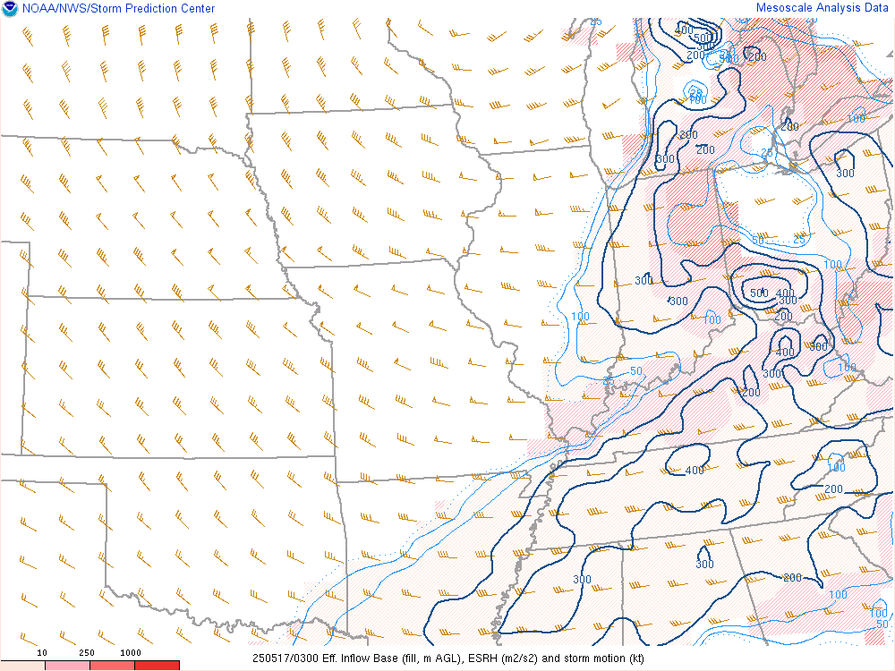
SPC Mesoscale Analysis data from 11 PM EDT (0300Z) on February 16th, 2025, indicated a 500-mb jet maximum (Figure 4) positioned just northwest of Kentucky. This placement was sufficiently close to support widespread 45 to 60 knots of effective bulk shear (Figure 5) across the state. This shear, coupled with minimal convective inhibition (Figure 6), strong low-level shear contributing to high helicity (Figures 7 and 8), and a balanced environment conducive to intense supercell thunderstorms, was well-represented by a broad area of high Significant Tornado Parameter (Figure 9).
 |
 |
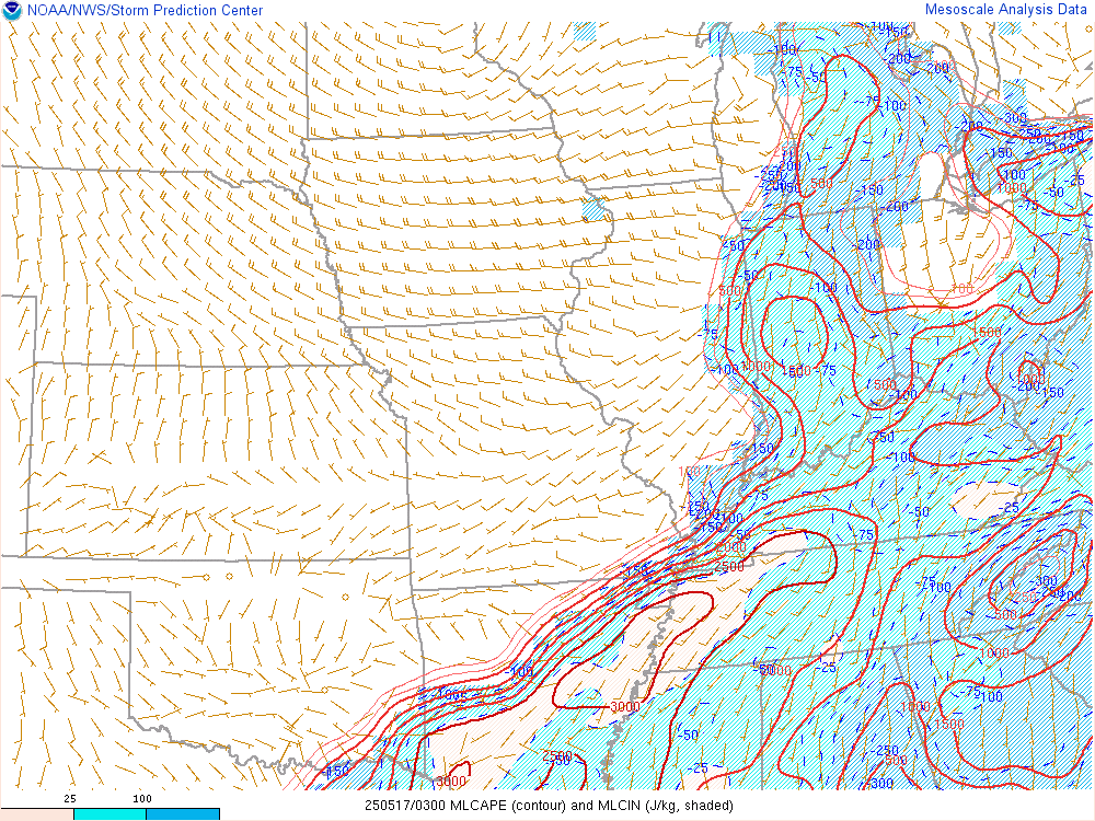 |
| Figure 4: 500 mb height, temperature, and wind | Figure 5: Effective bulk shear | Figure 6: MLCAPE |
 |
 |
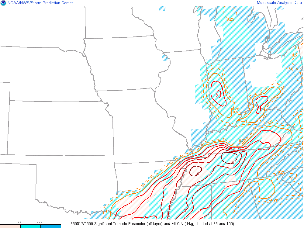 |
| Figure 7: Surface to 1 km shear vector | Figure 8: Effective inflow base, storm relative helicity, and storm motion | Figure 9: Significant Tornado Parameter and MLCIN |
 |
Media use of NWS Web News Stories is encouraged! Please acknowledge the NWS as the source of any news information accessed from this site. |
|


