Widespread life-threatening flash and urban flooding continues in south-central Texas, with considerable flooding impacts possible across central Texas. Wildfire smoke is impacting air quality across much of the Great Lakes region into southern New England and the Mid-Atlantic. Monsoonal thunderstorms may produce isolated to scattered flash flooding across the Southwest into the Great Basin. Read More >
Overview
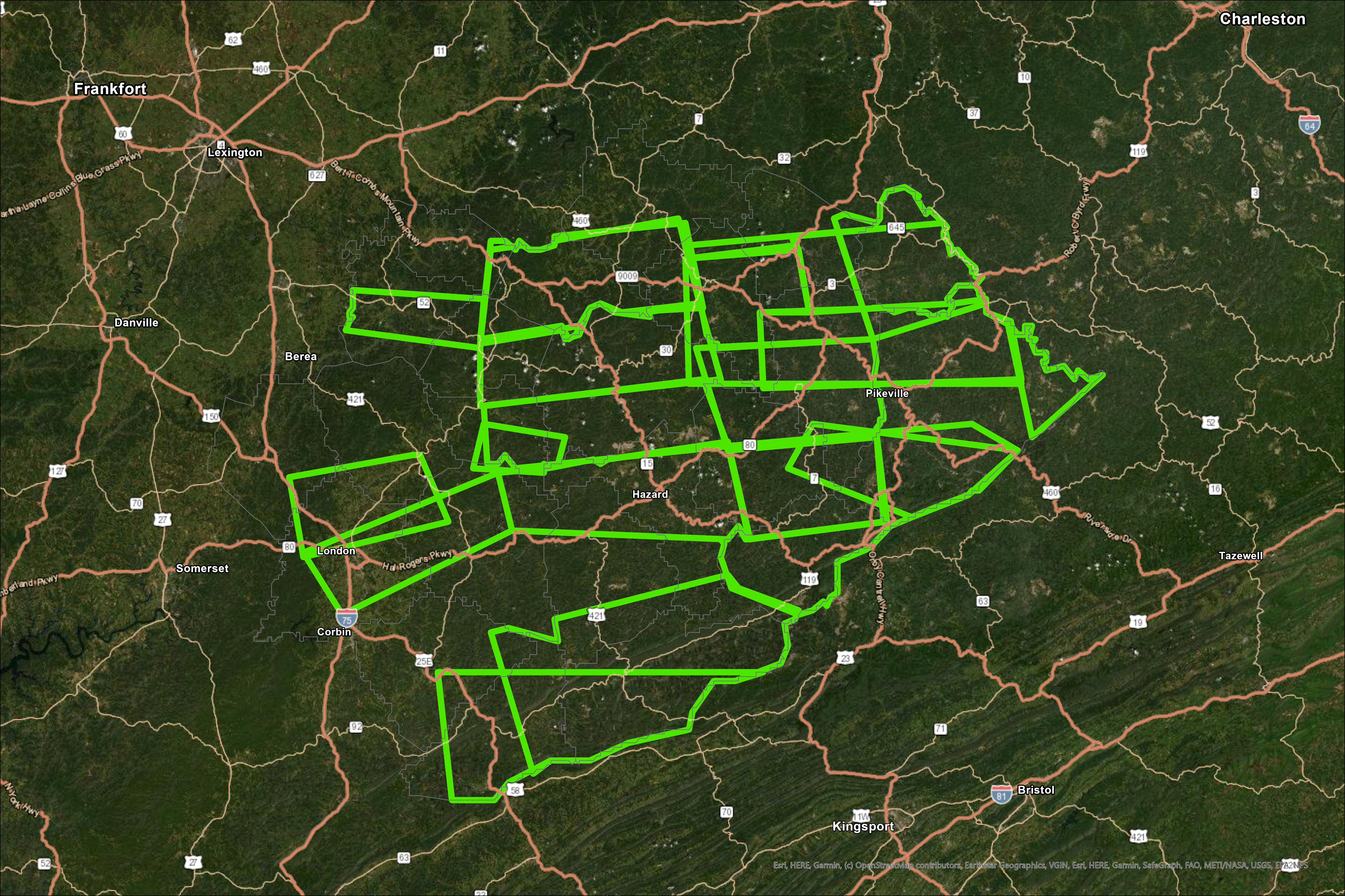
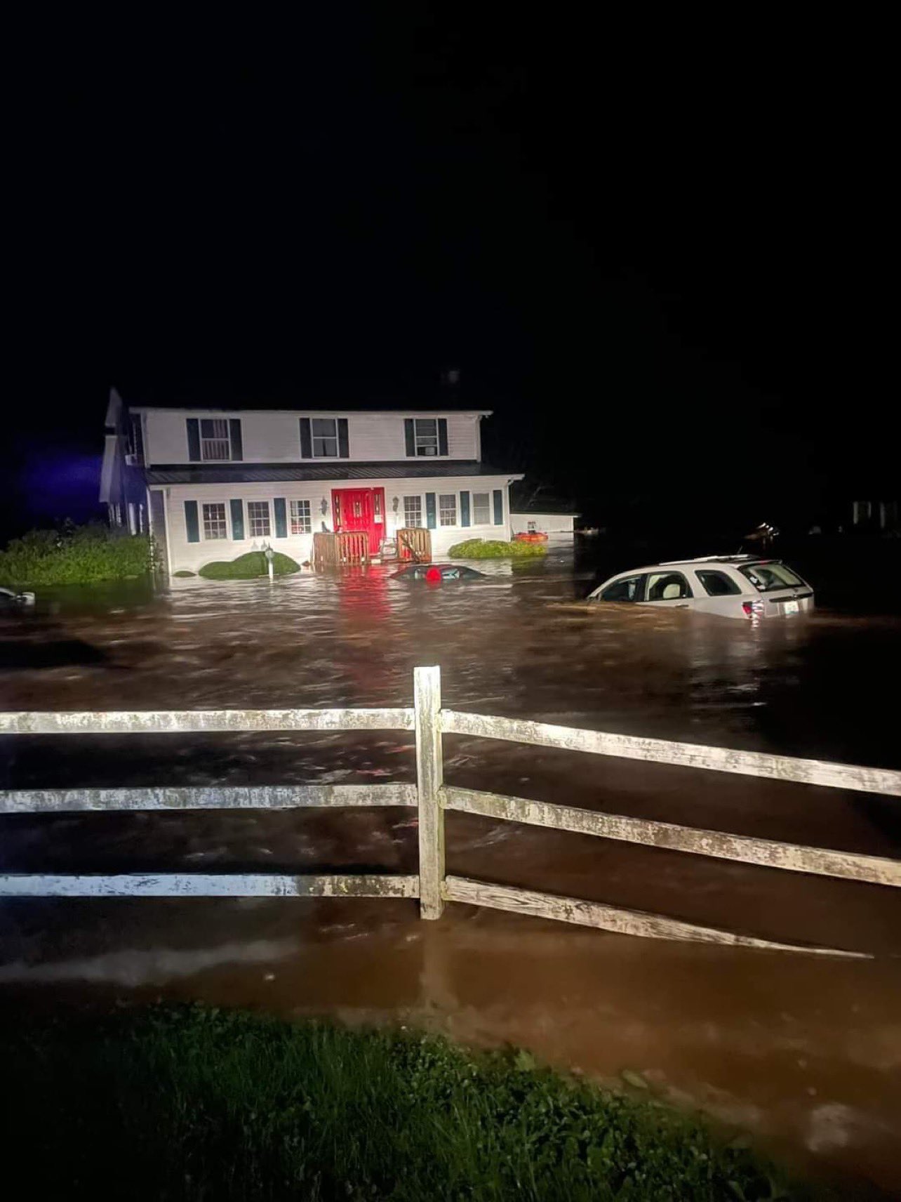
Between July 25th and July 30th, 2022, several complexes of training thunderstorms developed south of I-64 and brought heavy rain, deadly flash flooding, and devastating river flooding to eastern Kentucky and central Appalachia. These thunderstorms, at times, caused rainfall rates in excess of 4"/hr across complex terrain that led to widespread devastating impacts. While it did not rain continuously during this 4-day stretch, the overwhelming amounts of rain and resultant flooding led to 39 deaths and widespread catastrophic damage. Entire homes and parts of some communities were swept away by flood waters, leading to costly damage to infrastructure in the region. Over 600 helicopter rescues and countless swift water rescues by boat were needed to evacuate people who were trapped by the quickly-rising flood waters. In total, 24 Flash Flood Warnings were issued between July 26th and July 30th. Between the evening of July 27th and the mid-morning hours on July 28th (the peak of the event), 13 warnings were issued, 3 of which were upgraded to a Flash Flood Emergency.
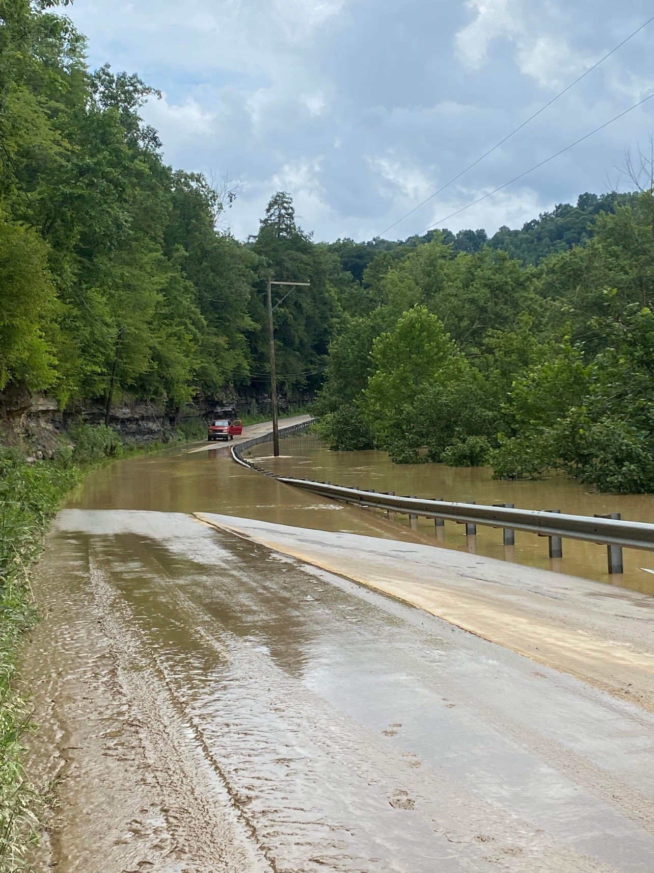
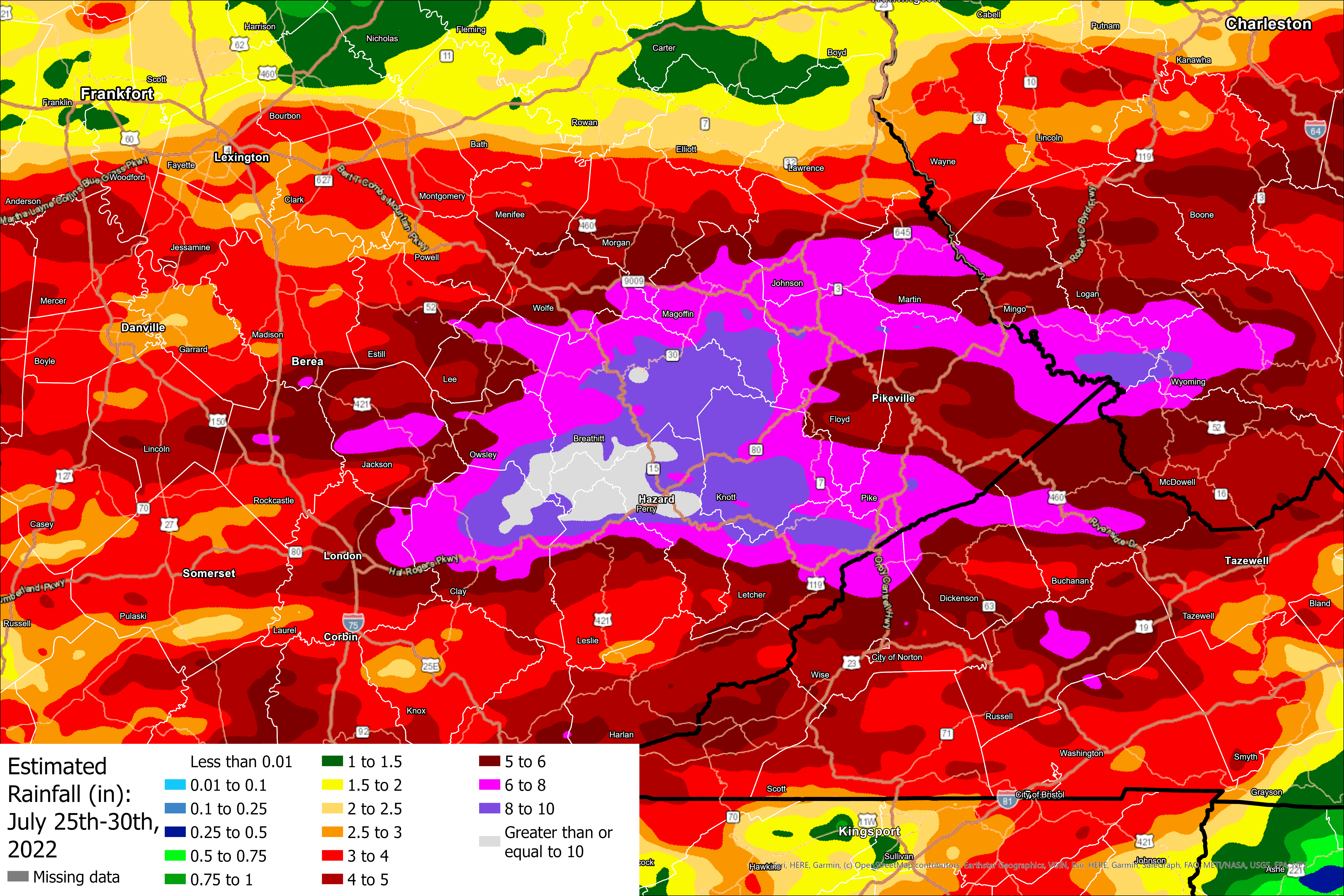
Radar-based rainfall estimates suggest that upwards of 14-16" of rain fell during this 5-day period in a narrow swath, with many more locations receiving 6-10" of rain. Most of this rain fell during the night of July 27th into the morning of July 28th, which is when the most devastating impacts were felt. The highest totals occurred across an axis that stretches from northern Clay and southern Owsley counties, east through southern Breathitt and northern Leslie counties, into Perry, Knott and Letcher counties. The highest rainfall total report was from southern Knott County, where 14.00" fell between July 25th and July 29th. This site, a cooperative (COOP) observer at Carr Creek Lake, reported 6.71" from 7am July 28th to 7am July 29th, following a report of 6.50" at that site on the previous day. Another COOP site in Buckhorn reported 8.00" of rain for the 24-hour period ending 7am on July 28th. The rainfall total in Buckhorn from July 25th to July 29th was 11.76". These rainfall values occurring in such a short period of time are incredibly rare: there is less than a 1 in 1000 chance for this much rainfall over five days in a given year.
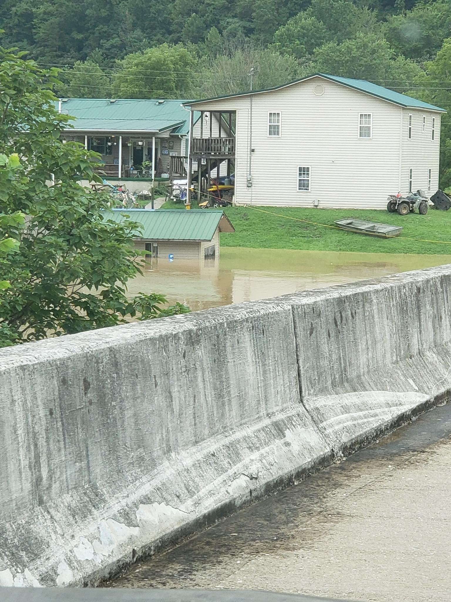
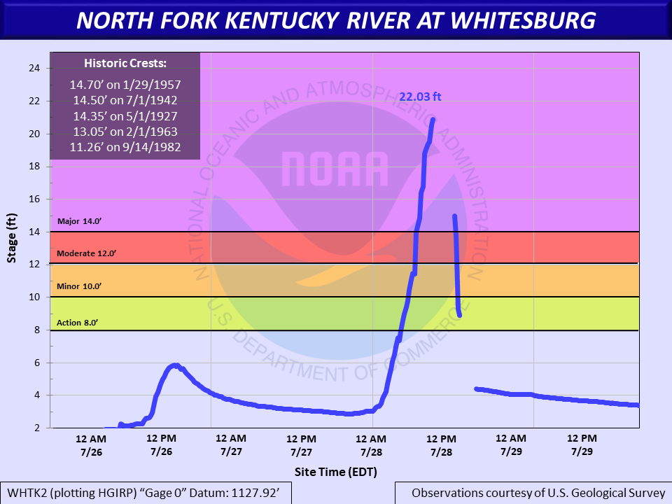
The incredible rainfall also led to significant rises and flooding on many rivers in eastern Kentucky including on the main stem of the Kentucky River; North, Middle and South forks of the Kentucky River; Red River and Licking River. At Whitesburg, the North Fork of the Kentucky River swelled well above major flood stage, reaching close to 21' before gauge failure (the previous flood of record was 14.7' in 1957). The North Fork of the Kentucky River at Jackson also reached major flood, setting a new record crest of 43.47' (the previous record was 43.1' set in 1939). The river flooding caused a second round of destruction for communities in the region, and caused flooding in downstream areas that did not receive as much rainfall.
|
Estimated rainfall totals from July 25th through July 30th, 2022 via NCEP Stage IV precipitation data. |
Flash Flood Warnings issued by NWS Jackson, KY from July 26th through July 30th, 2022. Three of these warnings were "Flash Flood Emergencies." This type of Flash Flood Warning is reserved for catastrophic flash flooding events. |
Weather and Climate Information
|
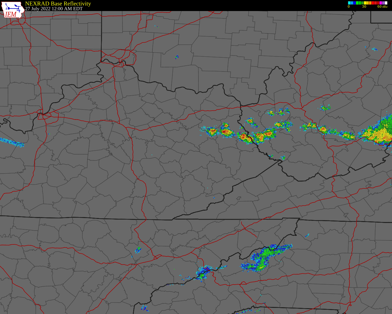
A regional radar loop from KJKL in Jackson, KY starting at 8:25pm on July 25th showing the development of training thunderstorms across eastern Kentucky and Flash Flood Warnings that were issued. Notice over the course of several days, thunderstorms impact the same area, causing devastating flooding. (IEM) |
|
|
Radar loop from KJKL in Jackson, KY on July 26th (IEM) |
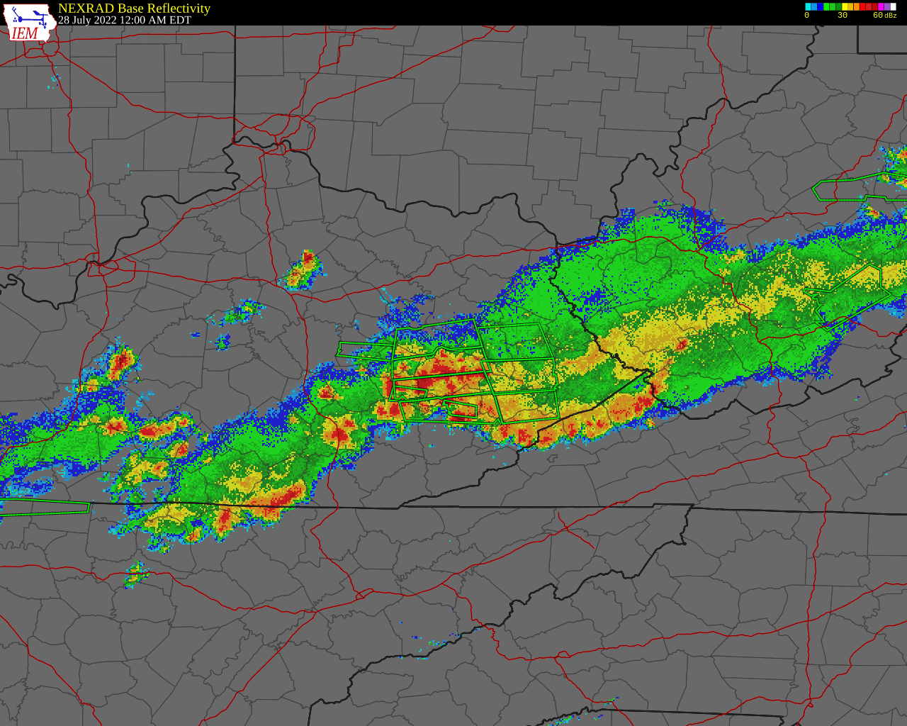
Radar loop from KJKL in Jackson, KY on July 27th (IEM) |
|
Radar loop from KJKL in Jackson, KY on July 28th (IEM) |
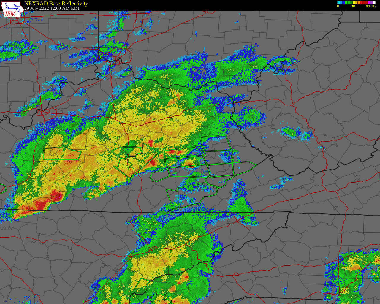
Radar loop from KJKL in Jackson, KY on July 29th (IEM) |
|
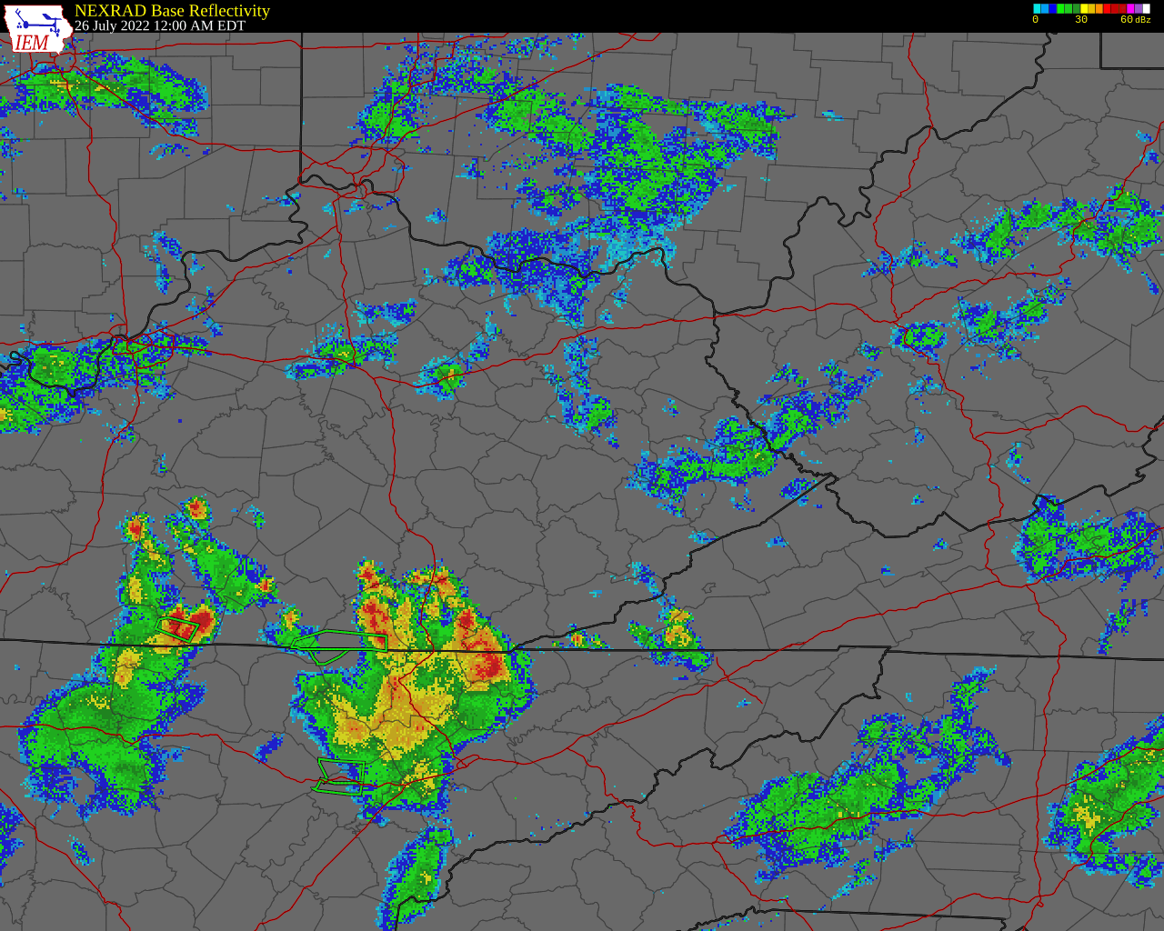
Light rain was falling late on July 25th and into the early morning of the 26th, before heavier rain entered the region around 6am on the 26th. An axis of training thunderstorms impacted parts of eastern Kentucky and southern West Virginia through the day. After a nearly 24-hour break from heavier, widespread rain (though a few thunderstorms did still impact the area) another round of training thunderstorms set up across eastern Kentucky during the evening of July 27th, warranting numerous Flash Flood Warnings and leading to the devastating impacts and loss of life. The training thunderstorms lasted for hours during the night of July 27th into the early morning of July 28th. These storms began to taper off just before 12pm on July 28th. Another round of thunderstorms then impacted the already-soaked region late that night into the morning of the 29th, adding insult to injury. |
|
|
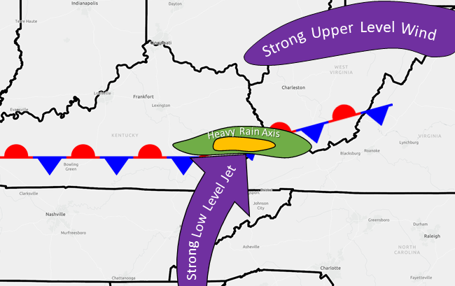
A conceptual model for the meteorological setup of the flash flooding event that occurred from July 26th to July 30th, 2022 in eastern Kentucky. This setup is described in further detail in this paper written by Moore et al. (2003) in the AMS Weather and Forecasting journal. |
The heavy rain fell north of a stationary front that was anchored across southern Kentucky. Strong low level winds (around 5,000 feet AGL) brought in copious amounts of low-level moisture, which interacted with the stationary front and the upper-level jet stream to produce repeated thunderstorms over the same areas for more than 6 hours - several days in a row. These thunderstorms caused an intense swath of heavy rainfall. Most of the area saw at least a few inches of rainfall, with a narrow band of 10 to 14" observed in east-central Kentucky. |
|
Climatological Context for This Devastating Flash Flooding Event
|
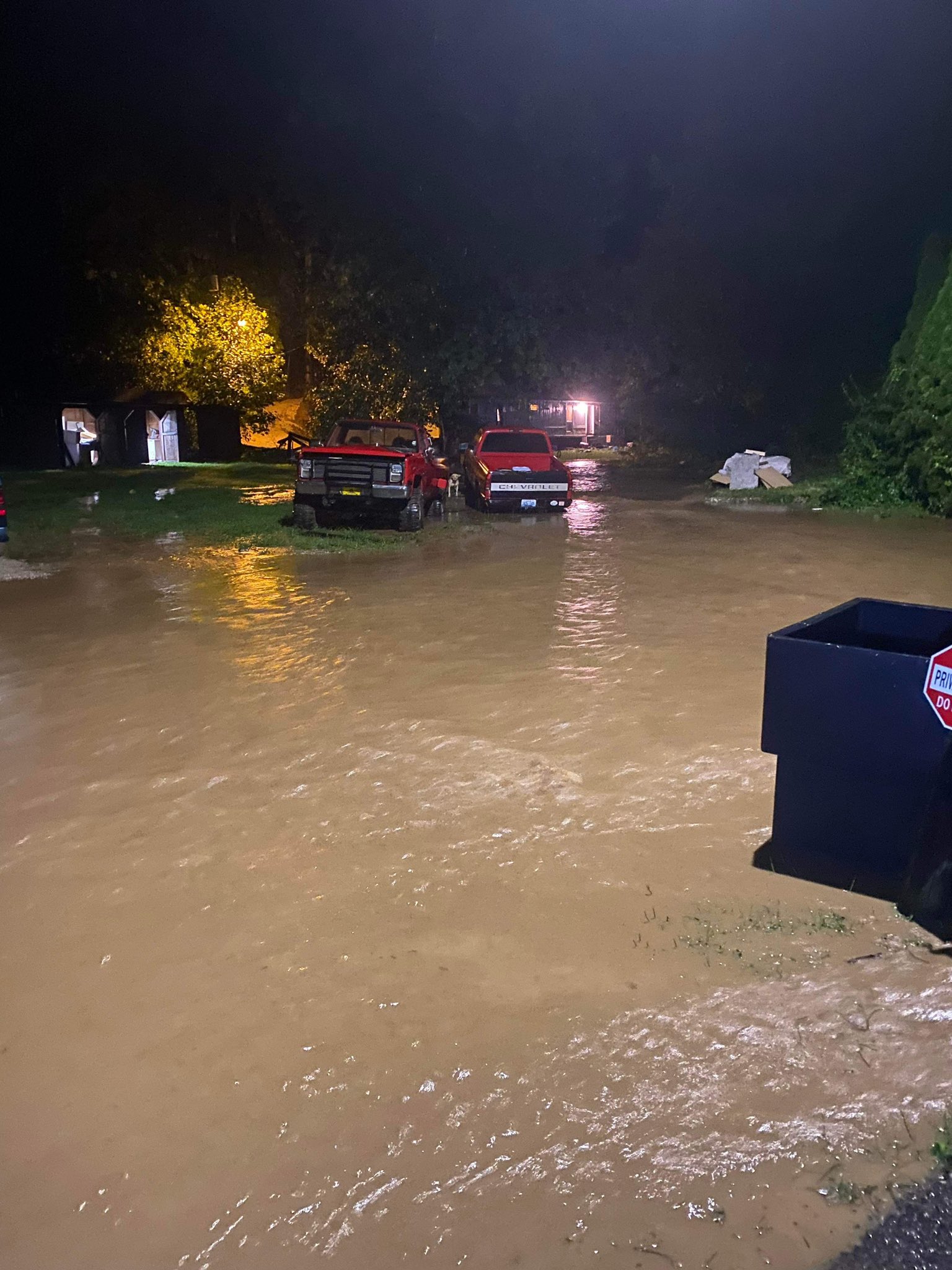
Flash Flooding Pictures/Videos: July 26th
|
|
|
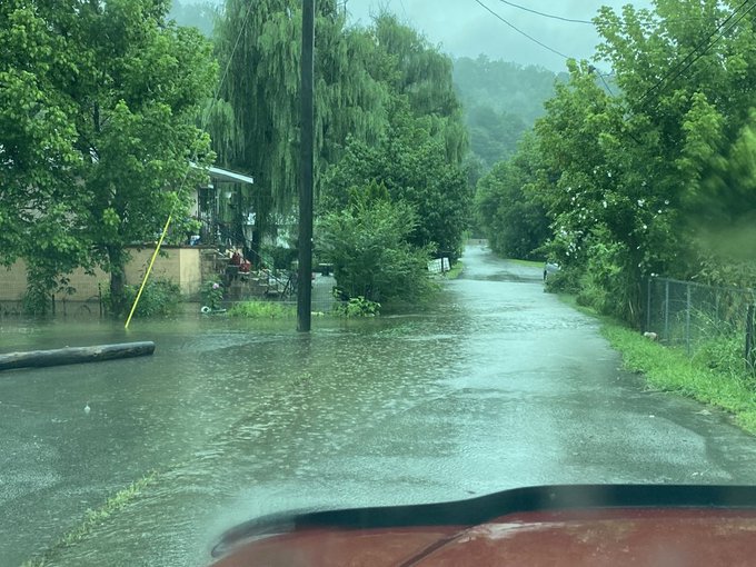
Water flowing over a road in Emma, KY (Keith Arnett, Twitter) |
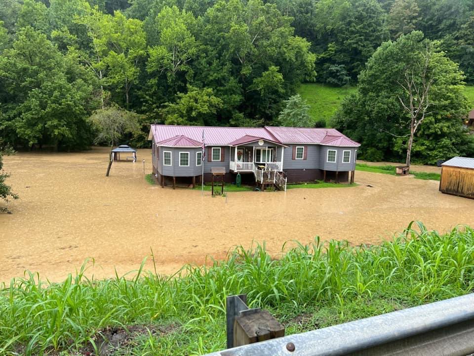
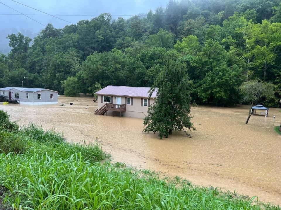
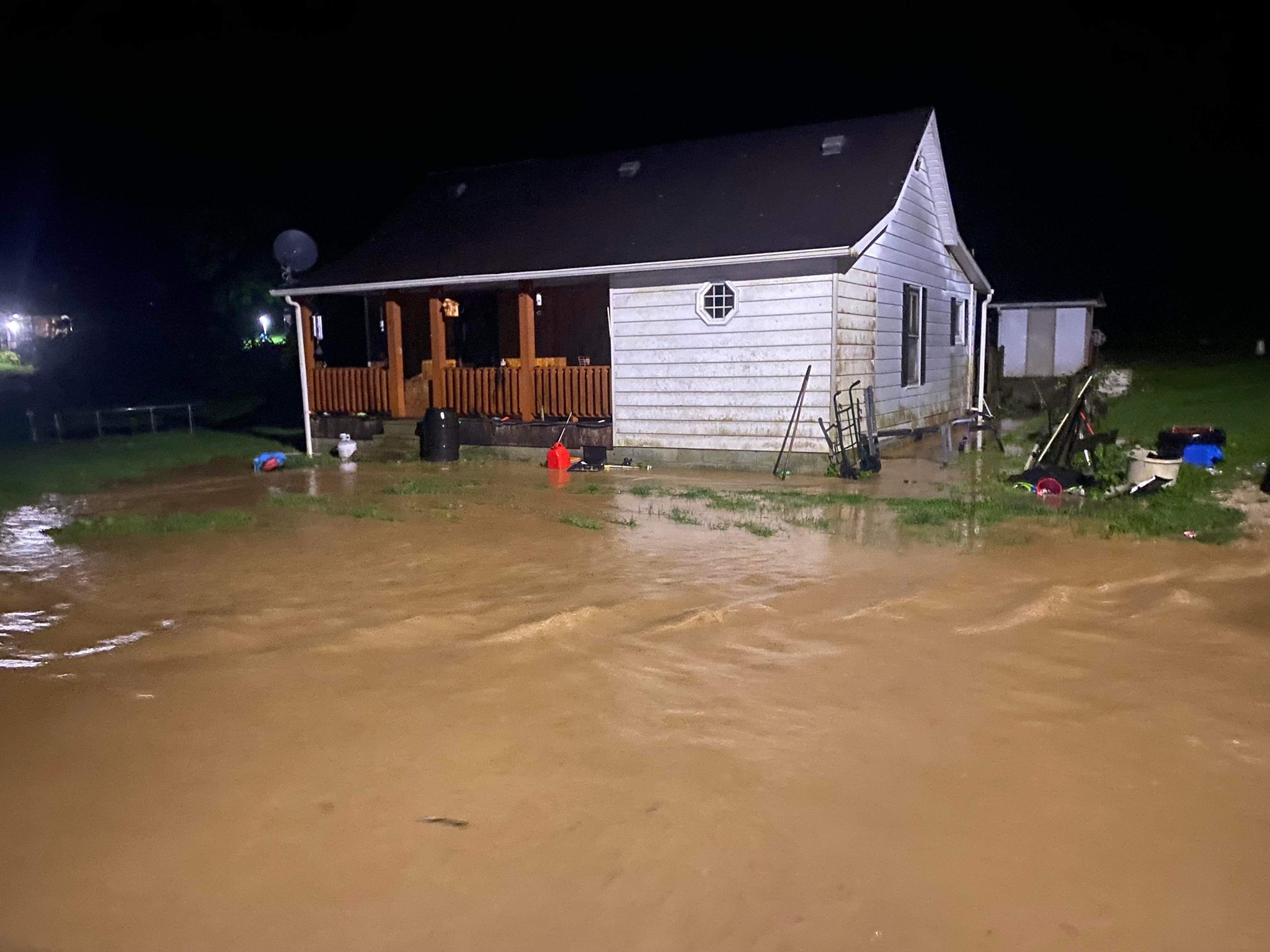
Water surrounding a home due to flooding in Floyd County, KY (Johnny Ray Feltner, Twitter) |
Water surrounding a home due to flooding in Floyd County, KY (Johnny Ray Feltner, Twitter) |
Flash Flooding Pictures/Videos: July 27th-28th
|
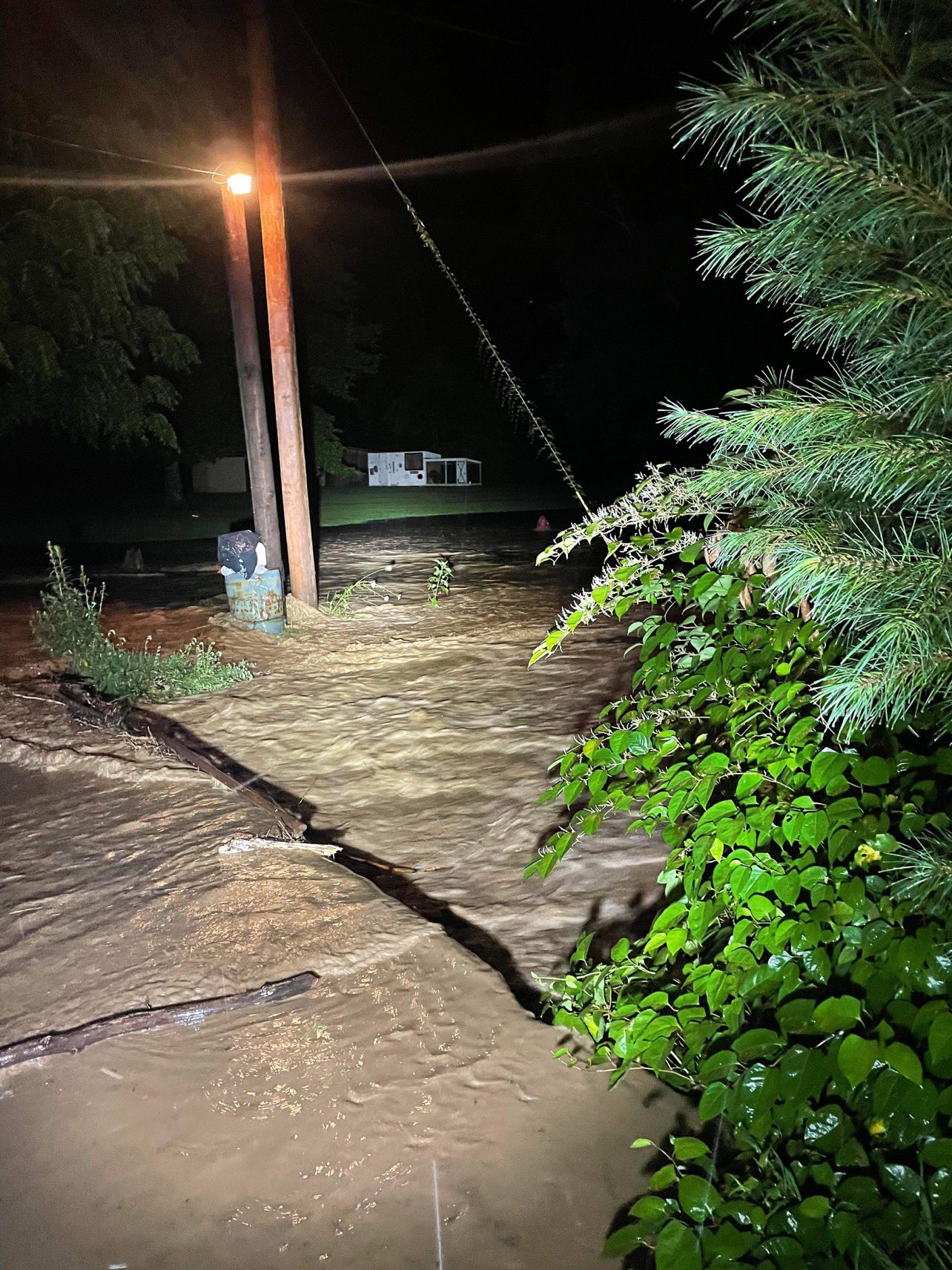
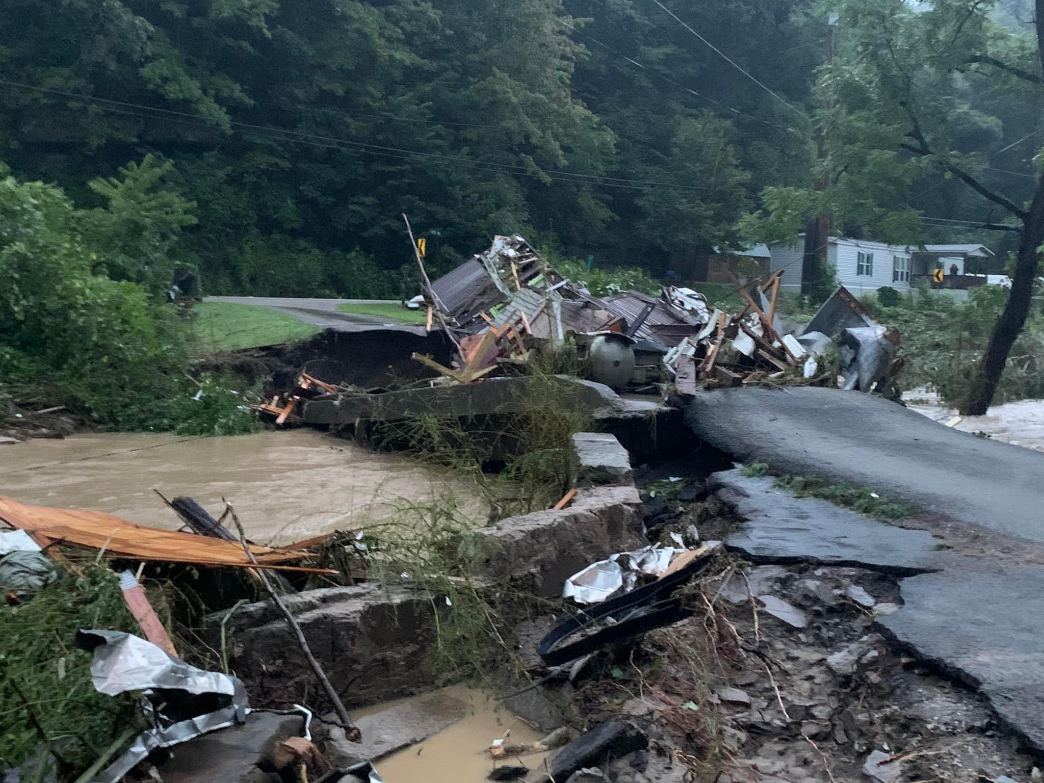
A road collapsed and washed away from flash flooding in Little Willard, KY (Brandon D. Smith, Facebook) |
Highway 899 at the Holly Hills Shopping Center in Hindman, KY flooding with flowing water evident (WKCB, Facebook) |
|
Highway 582 in Knott County, KY flooding and Pine Top Post Office mostly submerged (WYMT, Facebook) |
Flooding and rushing water on Old Jenson Rd Straight Creek, KY in Bell County (WRIL, Facebook) |
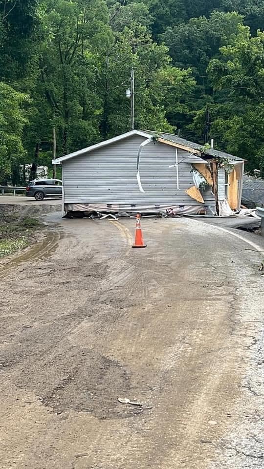
A home destroyed and laying in Lost Creek along Highway 15 at Lost Creek-Dice Rd at the Perry/Breathitt county line. (Megan Miller, Facebook) |
|
Rushing flood waters on Jett's Creek Rd on the Breathitt/Owsley County Line (Johnny Ray Feltner, Twitter) |
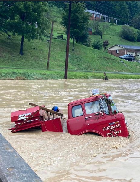
A fire engine submerged in flood waters in Hindman, KY in Knott County (Tyler Wolf, Facebook) |
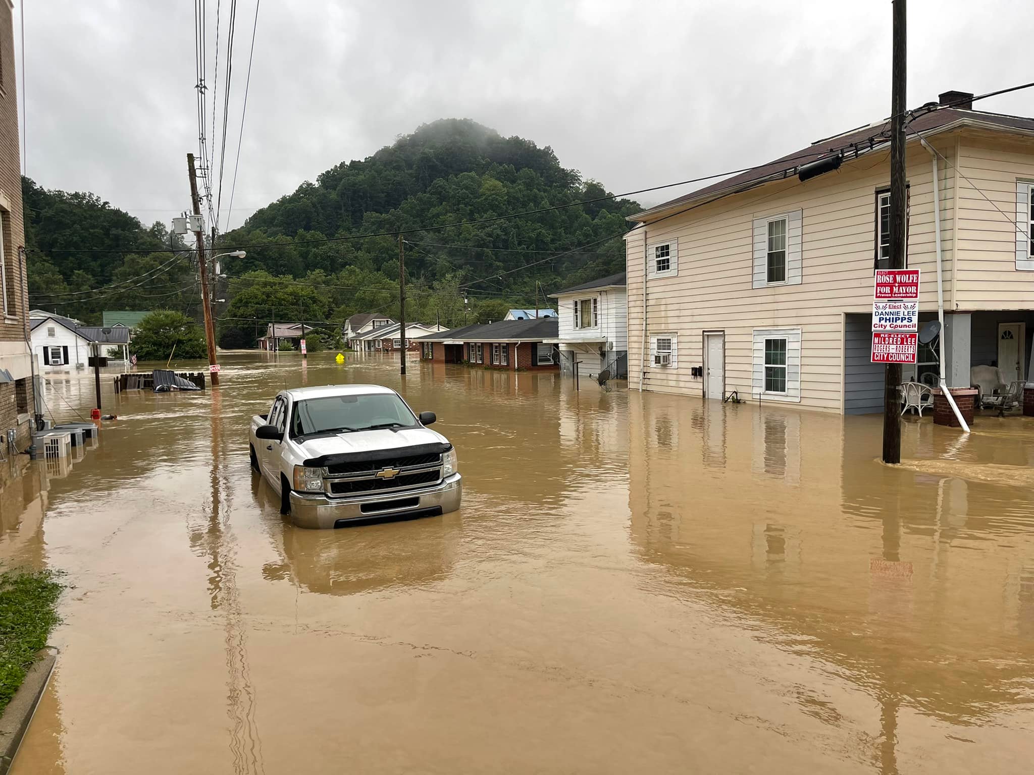
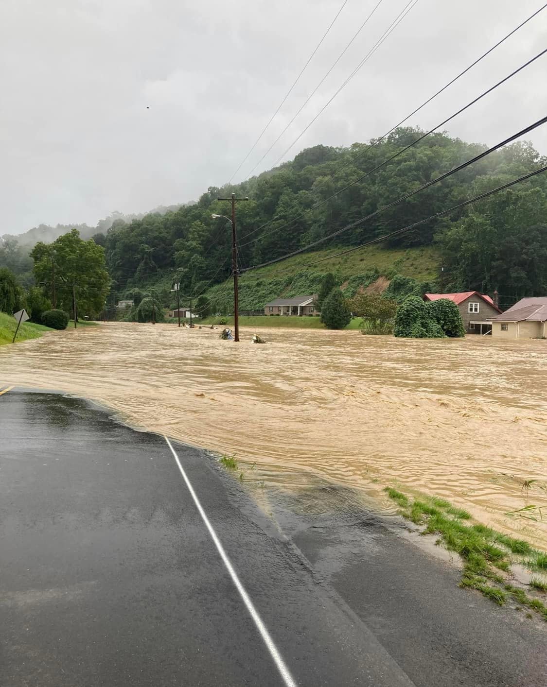
Flood waters over roads and surrounding houses in Hindman, KY (Tyler Wolf, Facebook) |
|
Aerial footage of flood damage to homes and infrastructure in Jackson, KY (Ben Childers, YouTube) |
Aerial footage of flood damage to homes and infrastructure in Whitesburg, KY (Live Storms Media, YouTube) |
Aerial footage of flood damage to homes and infrastructure in Hindman, KY (WXChasing, YouTube) |
|
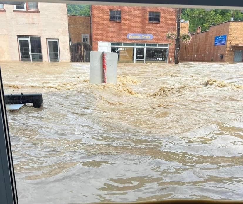
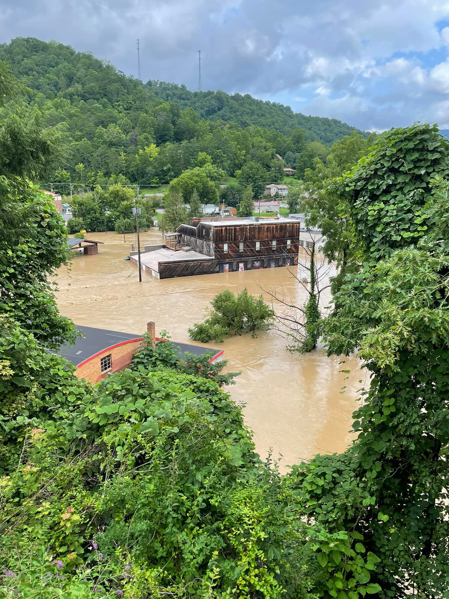
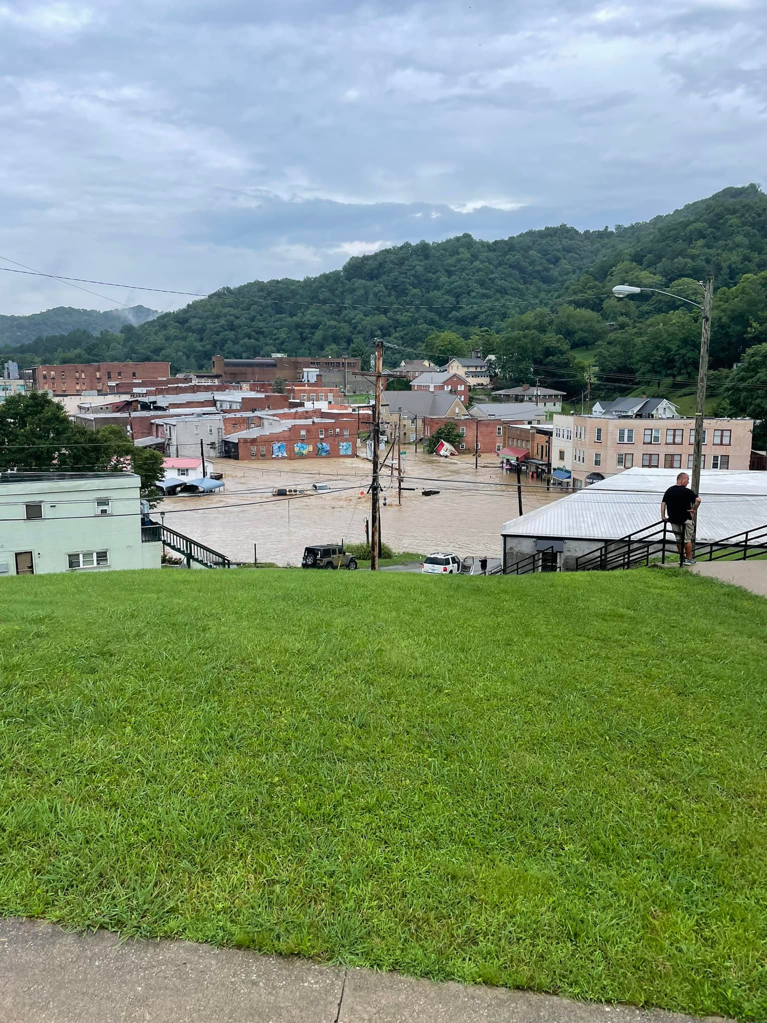
Several feet of flash flood water rushing down E Main Street (KY-15) in front of the Railroad Street Mercantile of downtown Whitesburg (Missy Bush, Facebook) |
Hidden Treasure Shop along E Main Street (KY-550) in Hindman severely damaged by flash flood waters from Troublesome Creek (Middlesboro Police Department, Facebook) |
Water rescue in Fisty, KY on July 28th (Sharla Stacy, Facebook) |
|
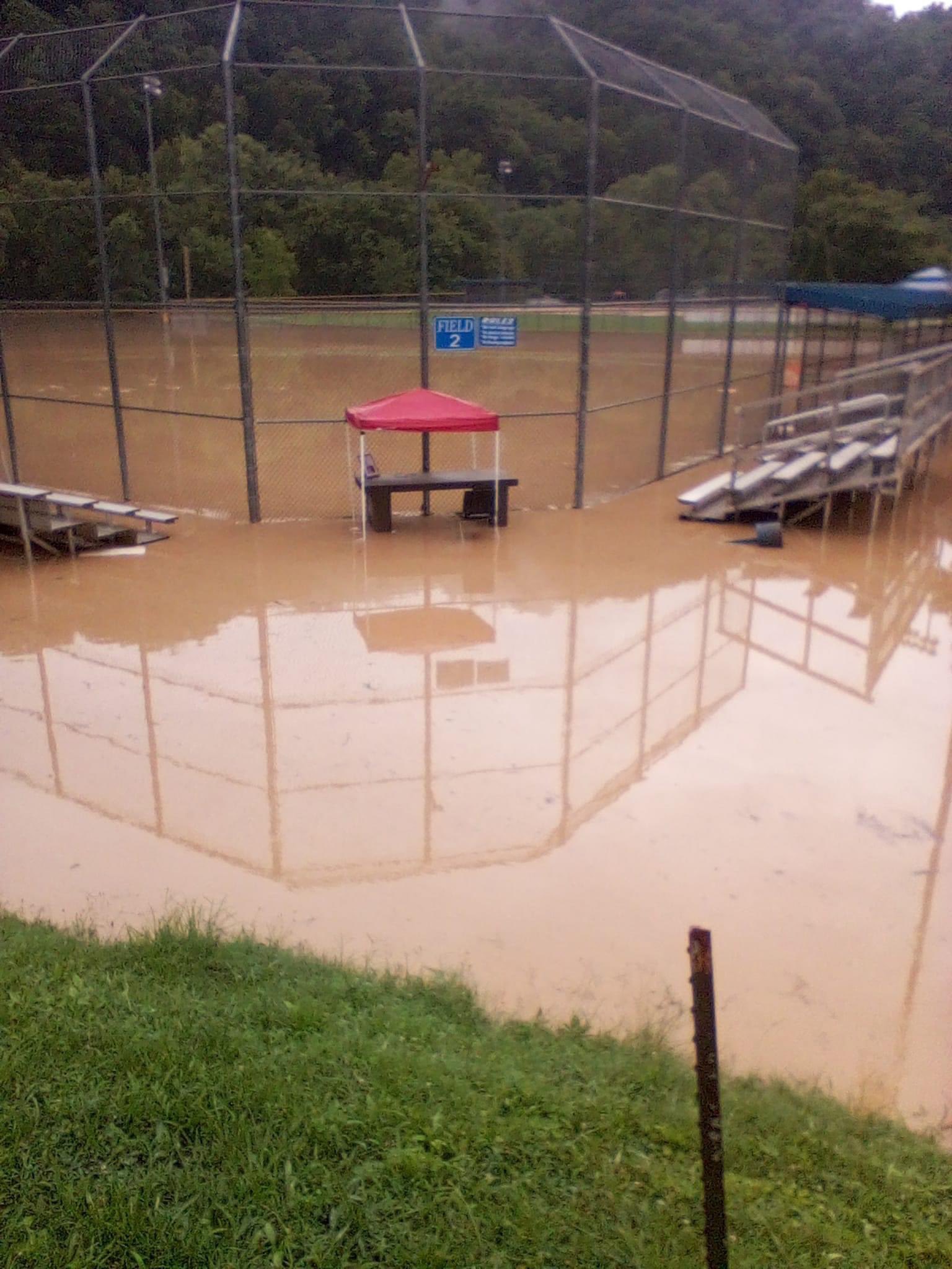
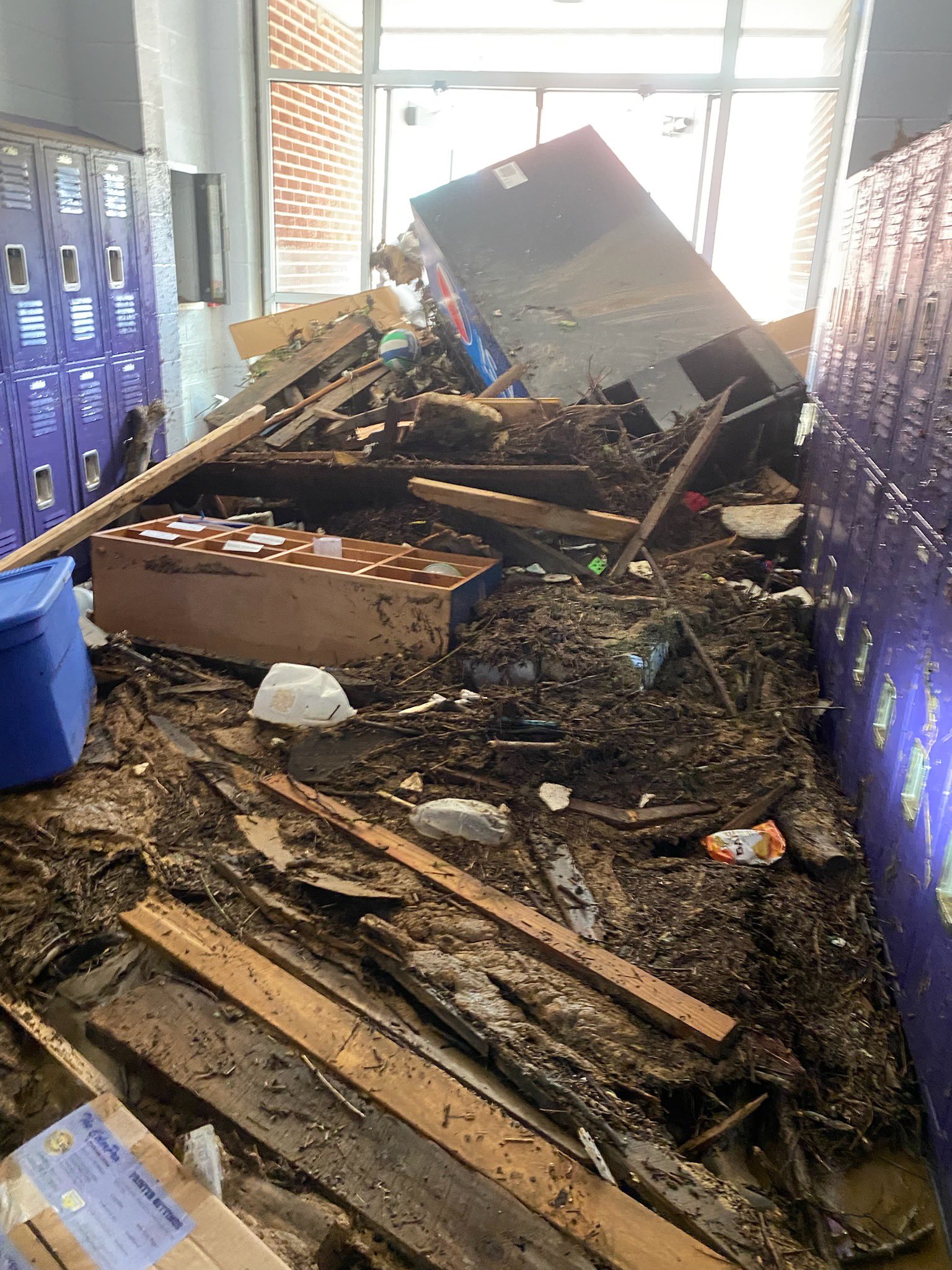
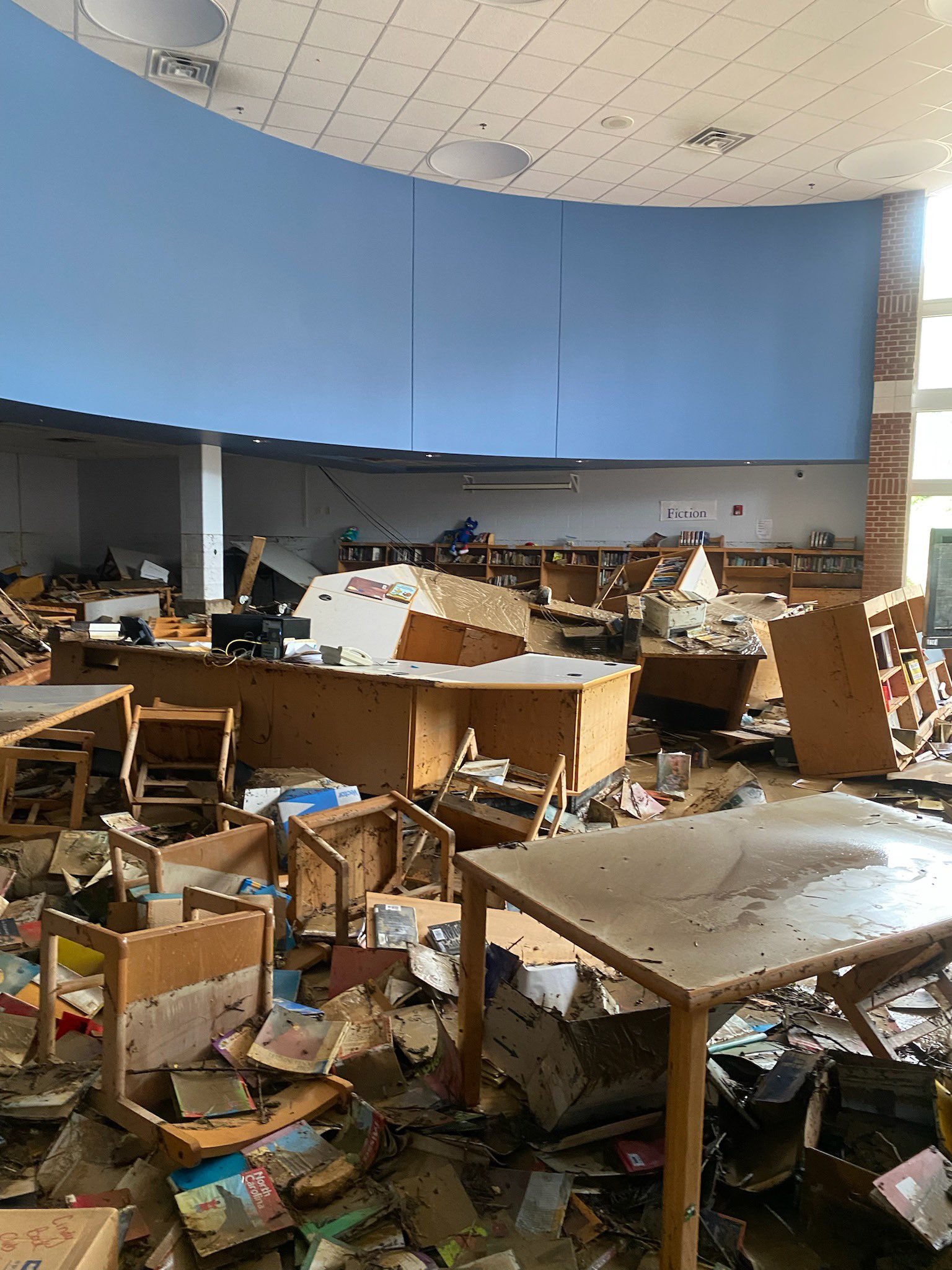
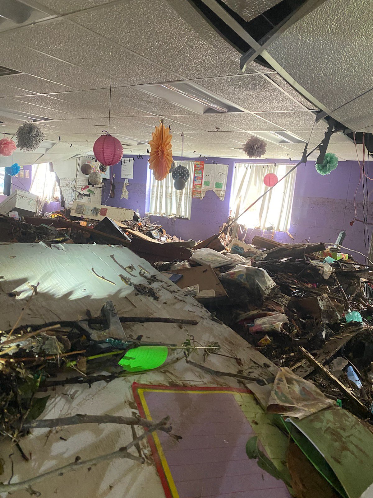
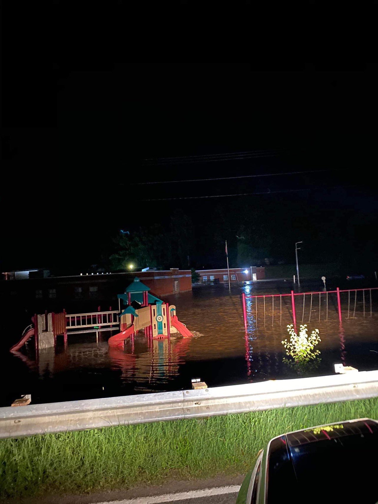
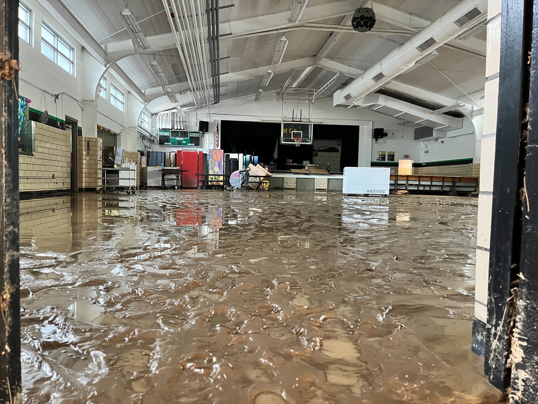
Buckhorn School in Perry County severely damaged due to flash flooding. (Adam Burniston, Twitter) |
Buckhorn School in Perry County severely damaged due to flash flooding. (Adam Burniston, Twitter) |
Buckhorn School in Perry County severely damaged due to flash flooding. (Adam Burniston, Twitter) |
|
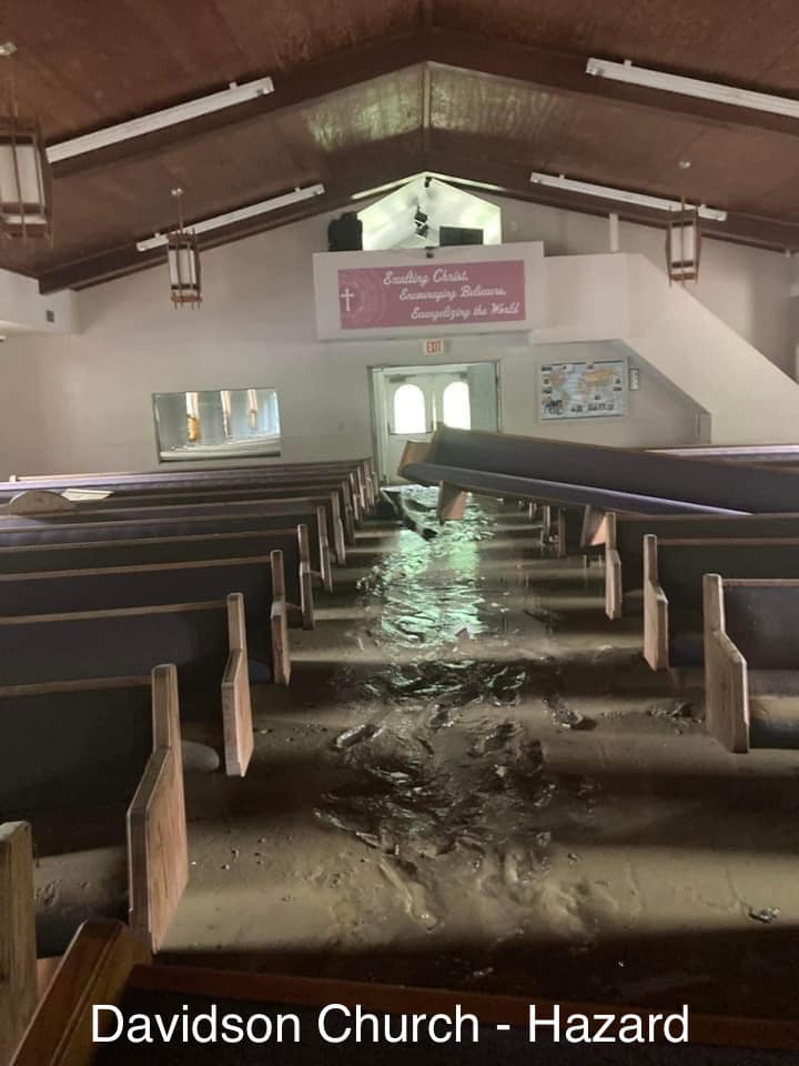
Davidson Church in Hazard, KY severely damaged by flash flooding (Missy Bush, Facebook) |
A road washed away due to flash flooding in Hardburly, KY (Phillip Scodellaro, Facebook) |
House and property inundated with water due to flash flooding in Emmalena, KY (Tim Hudson, Twitter) |
|
Severe flash flooding caused extensive damage in downtown Whitesburg, KY (Van Breeding, Facebook) |
Severe flash flooding caused extensive damage in downtown Whitesburg, KY (Van Breeding, Facebook) |
Pigeonroost-Bulan Rd flooded in Ary, KY due to flash flooding (Missy Bush, Facebook) |
|
Altro Church of God in Jackson, KY inundated by flash flooding (Johnny Ray Feltner, Twitter) |
Altro Church of God in Jackson, KY inundated by flash flooding (Johnny Ray Feltner, Twitter) |
Buckhorn School's playground under water due to flash flooding in Perry County, KY (Johnny Ray Feltner, Twitter) |
|
A house in Chavies, KY slid off its foundation and broke in half (Missy Bush, Facebook) |
Destroyed roads and structures due to flash flooding in Chavies, KY (Johnny Ray Feltner, Twitter) |
Destroyed roads and structures due to flash flooding in Chavies, KY (Johnny Ray Feltner, Twitter) |
|
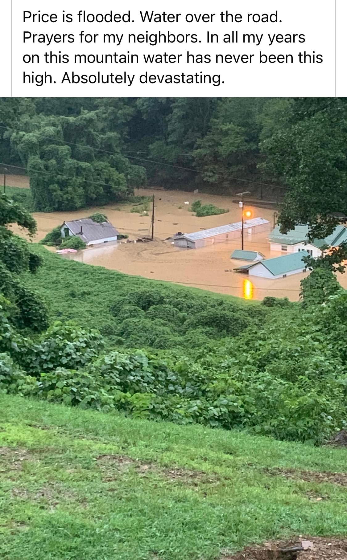
Catastrophic flooding in Price, KY (Missy Bush, Facebook) |
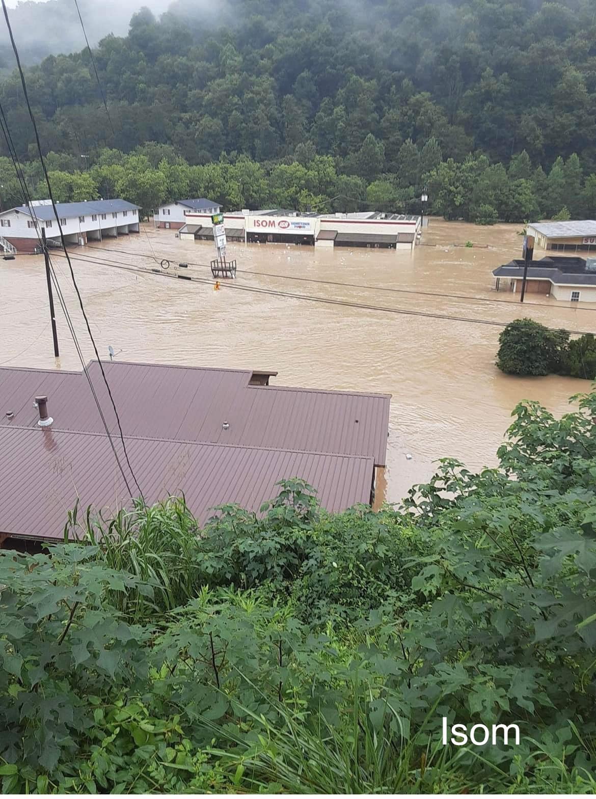
Catastrophic flooding in Isom, KY (Missy Bush, Facebook) |
A house completely submerged in water due to flash flooding and river flooding at Nobles Landing near Troublesome Creek (Missy Bush, Facebook) |
|
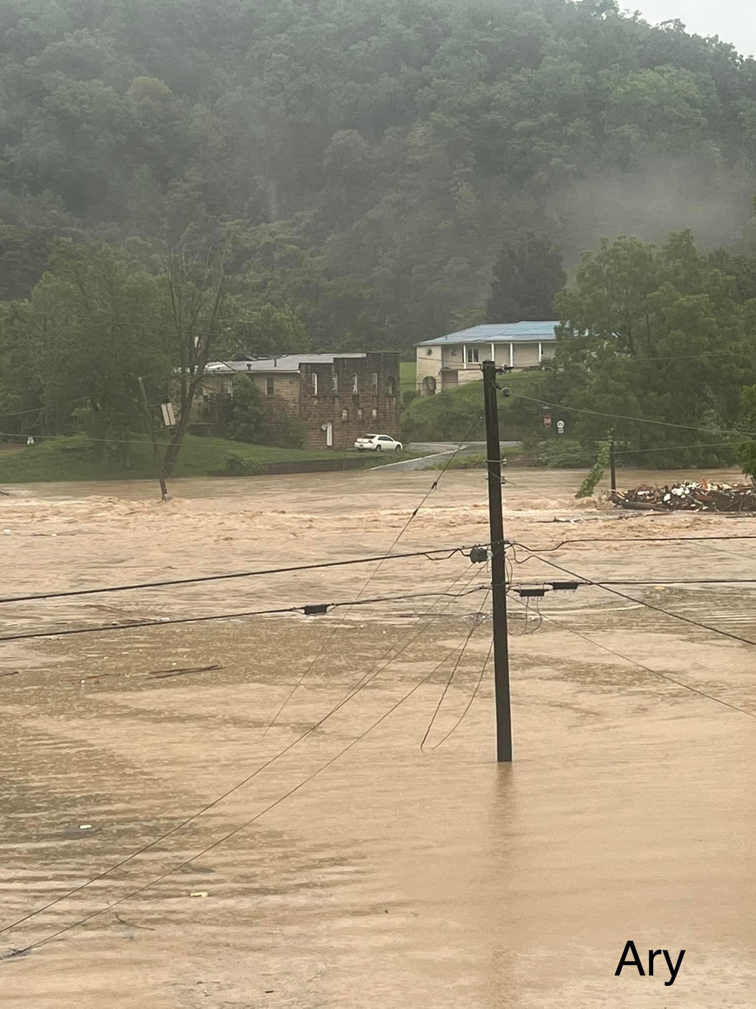
Robinson Elementary School in Ary, KY underwater due to flash flooding (Missy Bush, Facebook) |
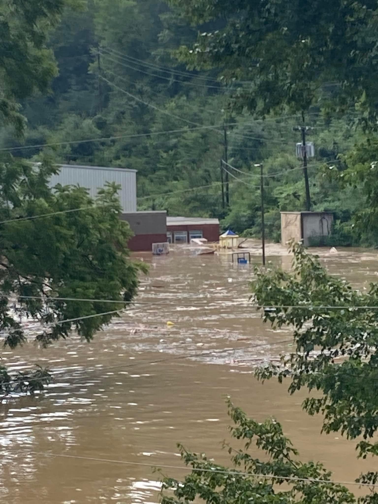
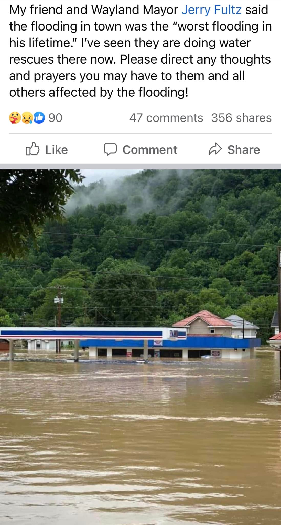
Gas station in Wayland, KY underwater due to flash flooding (Missy Bush, Facebook) |
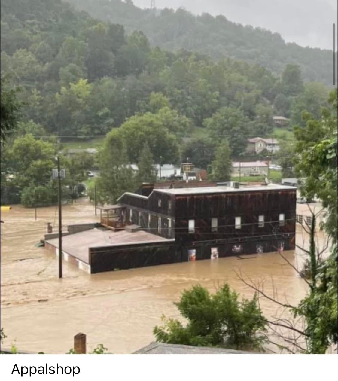
Flooding at the Appalshop Art Center in Whitesburg, KY (Missy Bush, Facebook) |
|
Long Fork Road partially washed out in Virgie, KY due to flash flooding (Buddy Forbes, Facebook) |
House swept onto Steer Fork Rd in Mallie, KY by flash flooding (Chad Hedrick WKYT, Facebook) |
Hindman Elementary School in Hindman KY damaged by flash flooding (LEX18 News, Twitter) |
|
Car destroyed in Hazard, KY (Johnny Ray Feltner, Facebook) |
Flash flooding on Hwy 476 at Hwy 15 in Breathitt County, KY (Johnny Ray Feltner, Twitter) |
Flash Flooding on Joe Little Fork Rd in Breathitt County, KY (Johnny Ray Feltner, Twitter) |
|
Flash Flooding on Joe Little Fork Rd in Breathitt County, KY (Johnny Ray Feltner, Twitter) |
Flash flooding Hwy 476 near Lost Creek in Breathitt County, KY (Johnny Ray Feltner, Twitter) |
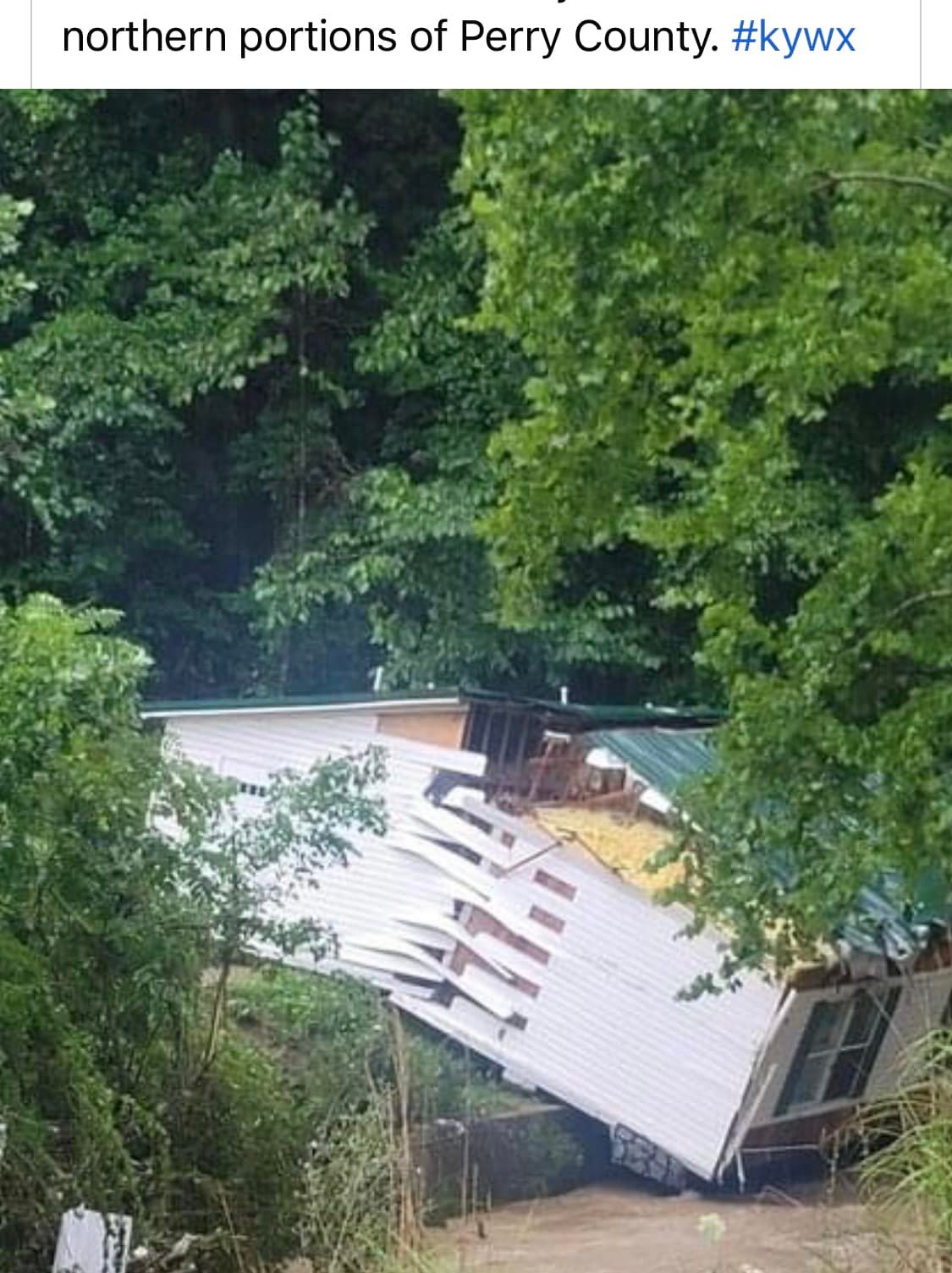
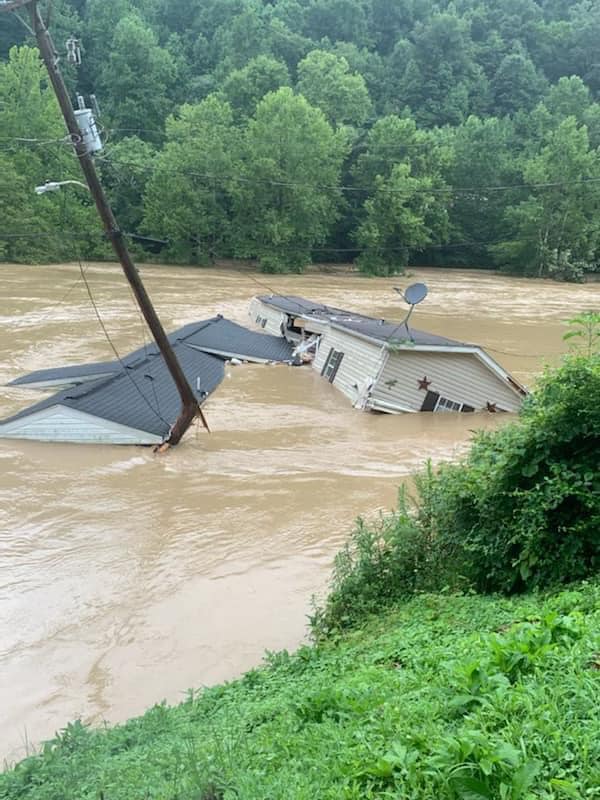
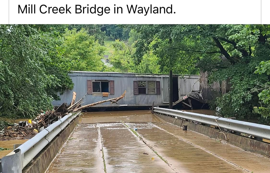
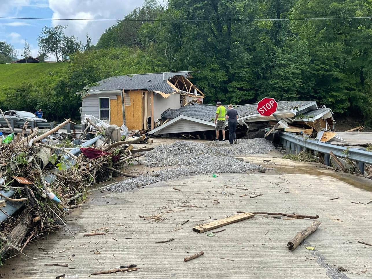
A single-wide swept across Mill Creek Bridge by flash flooding in Wayland, KY (Missy Bush, Facebook) |
|
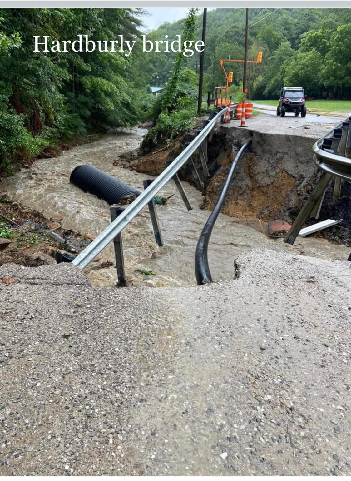
Hardburly Bridge in Hardburly, KY washed away due to flash flooding (Missy Bush, Facebook) |
Panco Creek in Clay County, KY washed a road away due to flash flooding (Missy Bush, Facebook) |
A road near Willard Branch in Pinetop, KY washed away by flash flooding (Missy Bush, Facebook) |
|
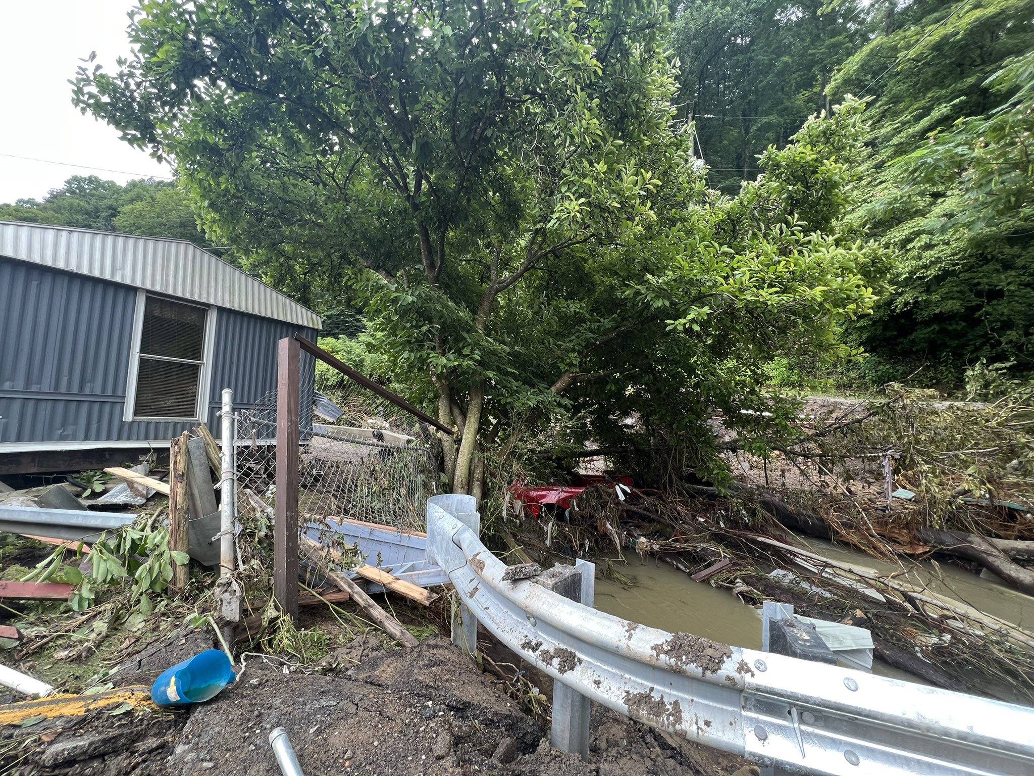
A house was destroyed by flash flooding on Steer Fork Rd in Pinetop, KY (Missy Bush, Facebook) |
A house was damaged by flash flooding in Bulan, KY (Katie Byrne, Twitter) |
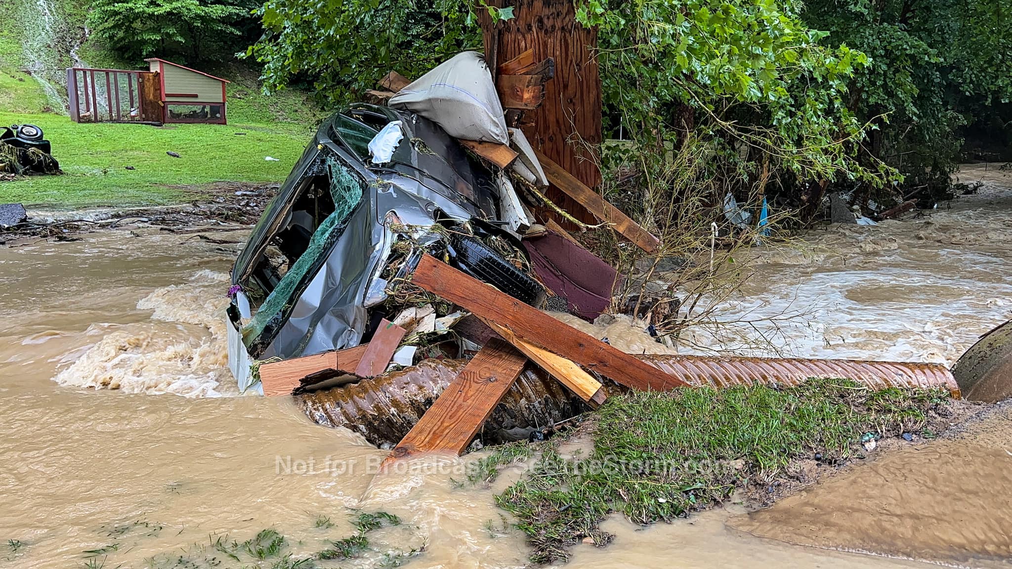
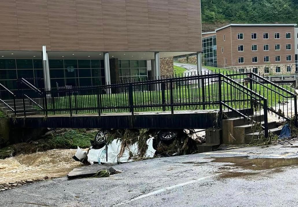
A car was swept off the road at Alice Lloyd College in Pippa Passes, KY (Missy Bush, Facebook) |
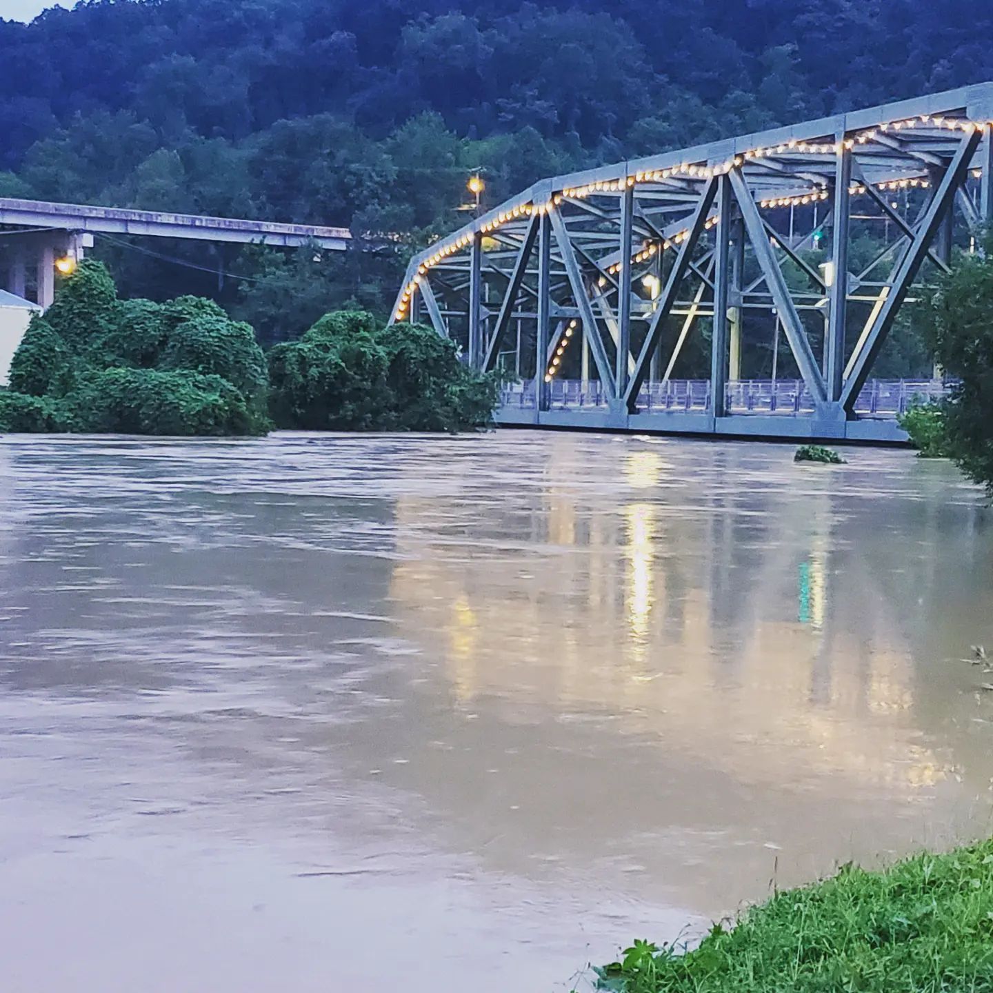
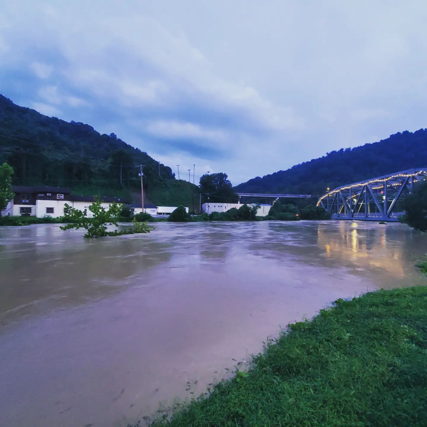
River Flooding Pictures/Videos: July 28th-29th
|
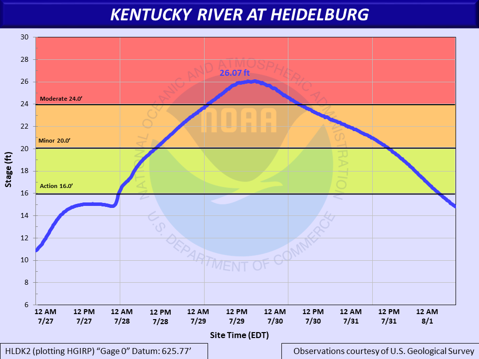
Hydrograph of the Kentucky River at Heidelberg, which crested at Moderate Flood Stage |
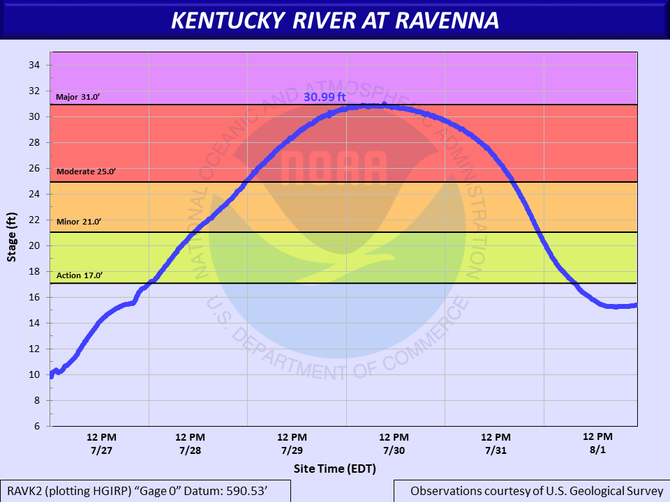
Hydrograph of the Kentucky River near Ravenna, which crested just below Major Flood Stage |
Hydrograph of the North Fork Kentucky River at Whitesburg, which crested at Major Flood Stage and set a new record crest |
|
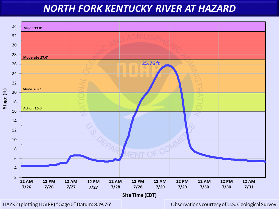
Hydrograph of the North Fork Kentucky River at Hazard, which crested at Minor Flood Stage |
Hydrograph of the North Fork Kentucky River at Jackson, which crested at Major Flood Stage and set a new record crest |
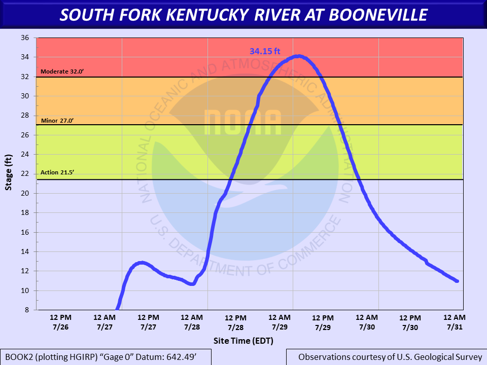
Hydrograph of the South Fork Kentucky River at Booneville, which crested at Moderate Flood Stage |
|
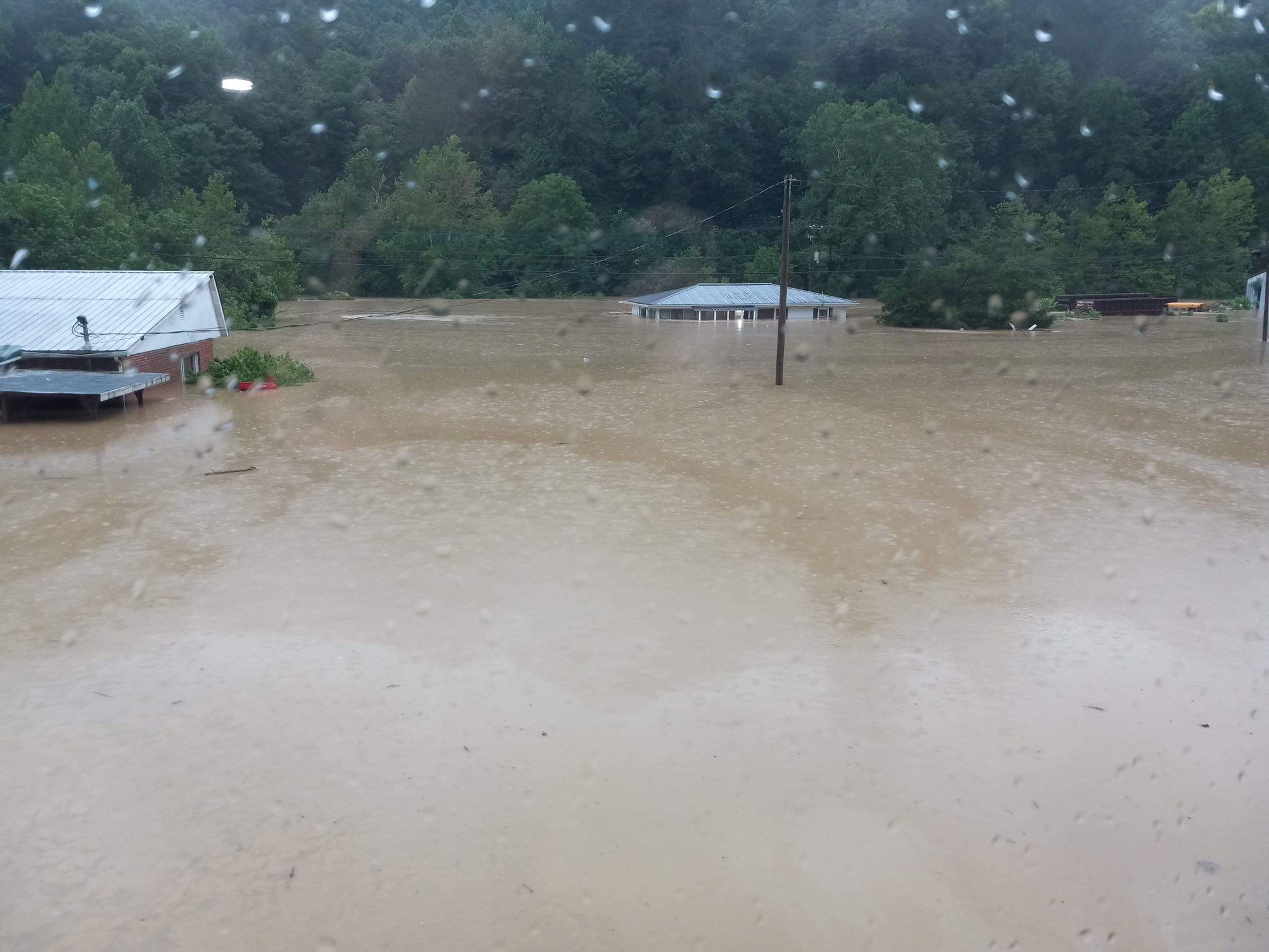
North Fork Kentucky River at Hazard, showing river levels touching the bridge (City of Hazard, Facebook) |
North Fork Kentucky River at Hazard, showing river levels touching the bridge (City of Hazard, Facebook) |
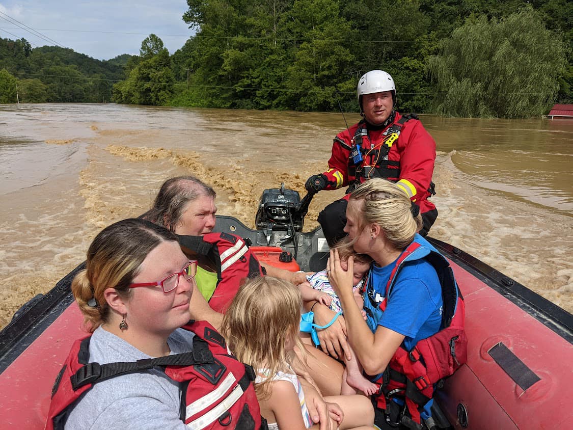
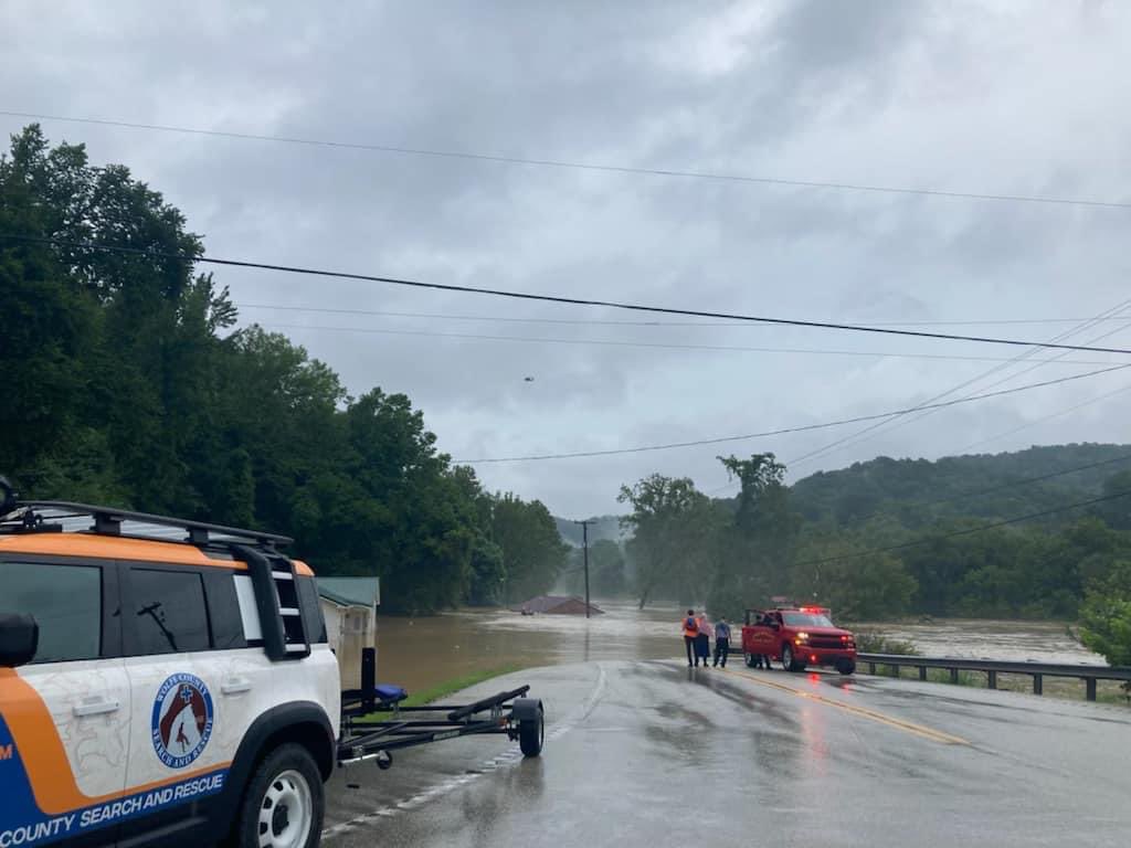
Wolfe County Search and Rescue transporting a family to safety after river levels rose to dangerous levels in Breathitt County, KY (Wolfe County Search and Rescue, Facebook) |
|
Wolverine community flooded by rising river waters in Breathitt County, KY (Johnny Ray Feltner, Twitter) |
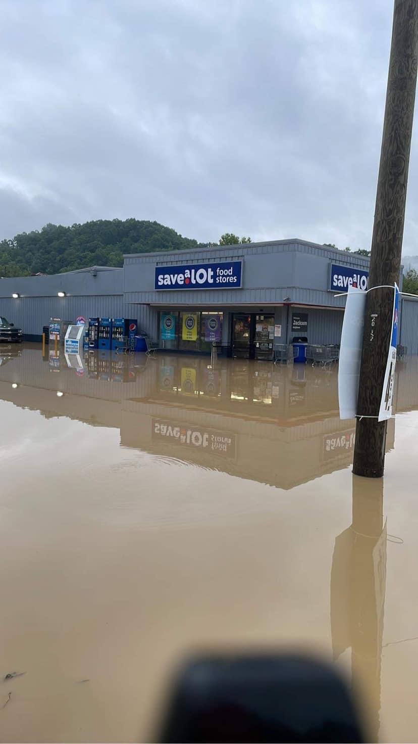
North Fork Kentucky River in Jackson flooding a Save-A-Lot (Johnny Ray Feltner, Twitter) |
North Fork Kentucky River flooding buildings in southwest Jackson, KY (Sean Moody, Facebook) |
|
Flooding on Canoe Rd in Jackson, KY from the Middle Fork Kentucky River (Johnny Ray Feltner, Twitter) |
Douthitt Park underwater in Jackson, KY due to river flooding (Johnny Ray Feltner, Twitter) |
Summary of Storm Reports
..TIME... ...EVENT... ...CITY LOCATION... ...LAT.LON...
..DATE... ....MAG.... ..COUNTY LOCATION..ST.. ...SOURCE....
..REMARKS..
1055 AM Flash Flood Bonanza 37.69N 82.87W
07/26/2022 Floyd KY Trained Spotter
1 1/2 to 2 feet of water flowing down Abbott
Creek Road.
1125 AM Flash Flood 1 SW Woodman 37.50N 82.07W
07/26/2022 Pike KY Emergency Mngr
Received a picture from the emergency
manager of water flowing over the road on
Highway 194 near the intersection with
Highway 2059, or Woodman Creek Road.
1145 AM Flash Flood Mccombs 37.65N 82.58W
07/26/2022 Pike KY Storm Chaser
Video footage shows flash flooding and a
debris flow over KY-194 near Spears Branch.
Time estimated.
1224 PM Flash Flood 1 NNW Ballot 37.79N 82.95W
07/26/2022 Magoffin KY Public
Flowing water surrounding a residence along
US-460 just west of the Magoffin/Johnson
County line.
0100 PM Flash Flood 2 N Mccombs 37.68N 82.59W
07/26/2022 Floyd KY Storm Chaser
Video footage show Brushy Fork flash
flooding over KY-194 at the intersection
with Brushy Creek Rd. Time estimated.
0100 PM Flash Flood 1 E Gulnare 37.63N 82.53W
07/26/2022 Pike KY Emergency Mngr
Emergency manager sent a photo of water
flowing over the road along Sycamore Creek.
0100 PM Flash Flood 1 SSE Ivel 37.58N 82.66W
07/26/2022 Floyd KY Public
Received report from social media with
photos showing water surrounding multiple
homes in the Ivel community.
0123 PM Flash Flood Royalton 37.67N 83.02W
07/26/2022 Magoffin KY Broadcast Media
Water running across Route 7 near Royalton
based on a picture from Twitter.
0130 PM Flash Flood 1 ENE Ivel 37.60N 82.64W
07/26/2022 Floyd KY Public
Video footage show Ivy Creek flash flooding
across Ivy Creek Rd. Time estimated.
0201 PM Flash Flood Emma 37.64N 82.70W
07/26/2022 Floyd KY Public
Public reported water flowing over a street
in Emma, KY after torrential rainfall.
0619 AM Flash Flood 1 NW Ashcamp 37.28N 82.45W
07/27/2022 Pike KY 911 Call Center
Pike County dispatch reports that at the
10,000 block of Ashcamp Rd was closed due to
high water.
0707 AM Flash Flood 2 SSE Ligon 37.34N 82.65W
07/27/2022 Pike KY 911 Call Center
Pike County dispatch reports that Indian
Creek Rd past Sunny Fork was closed due to
high water.
0926 PM Flash Flood 1 NNE Hollonville 37.68N 83.46W
07/27/2022 Wolfe KY Public
Flash flood waters reported up to the
porches on Terrill Fork and Holly roads.
1012 PM Flash Flood 1 ENE Sewell 37.63N 83.38W
07/27/2022 Breathitt KY Public
Pictures on social media show flash flood
waters surrounding vehicles at Morgue Fork.
1015 PM Flash Flood 1 SE Whynot 37.64N 83.78W
07/27/2022 Lee KY Law Enforcement
State trooper reported running water and
debris across KY-52 at the intersection of
KY 2453.
1020 PM Flash Flood 1 NE Sewell 37.64N 83.38W
07/27/2022 Breathitt KY Trained Spotter
Report of flood water over Morgue Fork road.
1055 PM Flash Flood Lee City 37.74N 83.34W
07/27/2022 Wolfe KY Public
Flash flood waters reported in the
churchyard at the Lee City First Church of
God.
1055 PM Flash Flood 1 S Lee City 37.73N 83.33W
07/27/2022 Wolfe KY Public
Flash Flood Waters reported over KY-205 in
the vicinity of the intersection of Trent
Fork and Greenbrier Branch Rd.
1058 PM Flash Flood Keck 37.61N 83.36W
07/27/2022 Breathitt KY Public
Video on social media showed flash flood
waters around a home at the intersection of
Strong Fork Rd and KY-1812.
1100 PM Flash Flood 1 N Hollonville 37.68N 83.47W
07/27/2022 Wolfe KY Public
Report of main bridge along KY-1261 flooded
along with multiple places with flood debris
in road.
1100 PM Flash Flood 2 NE Guerrant 37.52N 83.47W
07/27/2022 Breathitt KY Trained Spotter
Several reports of water and debris over
road at both Puncheon Creek Road and Belcher
Fork Road.
1100 PM Flash Flood 1 W Sebastian 37.36N 83.63W
07/27/2022 Owsley KY Public
Pictures on social show significant flash
flood damage along Buffalo Creek including a
home washed off its foundation and
destroyed. Onset time of flash flooding
estimated.
1100 PM Flash Flood 2 NE Gypsy 37.69N 82.94W
07/27/2022 Floyd KY Fire Dept/Rescue
Fire department reports Cole Branch Road
closed due to flash flooding.
1101 PM Flash Flood 2 S Elkatawa 37.53N 83.42W
07/27/2022 Breathitt KY Public
Flash flood waters reported over Belcher
Fork Rd. near the intersection with KY-30.
1101 PM Flash Flood 1 ENE Guerrant 37.51N 83.48W
07/27/2022 Breathitt KY Public
Flash flood waters reported over Puncheon
Creek Rd.
1108 PM Debris Flow 1 SSE Chenowee 37.53N 83.47W
07/27/2022 Breathitt KY Public
Debris flow and flash flooding reported in
the 2600 block of Puncheon Creek Rd.
1115 PM Flash Flood 1 S Paxton 37.66N 83.41W
07/27/2022 Breathitt KY Public
Public and social media reported flash
flooding in the Vancleve and KY-205 area
from KY-1812 to Polecat Branch areas.
1120 PM Flash Flood Stevenson 37.59N 83.26W
07/27/2022 Breathitt KY Public
Flash flood waters reported inside two
residences along Meat Scaffold Rd.
1130 PM Flash Flood Irvine 37.69N 83.97W
07/27/2022 Estill KY Public
Street flooding reported on Broadway in
Irvine and Ravenna. Time estimated.
1148 PM Flash Flood 1 NW Beech 37.38N 83.45W
07/27/2022 Breathitt KY Public
Bridge washed out along Bowling Creek Road
near Altro.
1150 PM Flash Flood 1 SSW Barwick 37.36N 83.37W
07/27/2022 Breathitt KY Public
Flash flooding reported near Barwick.
1156 PM Flash Flood 1 NW Beech 37.38N 83.45W
07/27/2022 Breathitt KY Trained Spotter
Water flowing over the road and impacting a
bridge on Bowlings Creek Rd.
1200 AM Flash Flood 2 SE Carrie 37.31N 83.01W
07/28/2022 Knott KY Public
Pictures on social media show flash flooding
around the Big Branch Baptist Church. Onset
time estimated.
1207 AM Flash Flood 1 WNW Beech 37.37N 83.44W
07/28/2022 Breathitt KY Public
Pictures on social media show considerable
flash flooding along Bowling Creek Road near
Altro and the Breathitt/Perry county line.
1212 AM Flash Flood Eversole 37.45N 83.64W
07/28/2022 Owsley KY Public
Water reported flowing over the road along
Bear Run.
1213 AM Flash Flood 1 ENE Simpson 37.67N 83.35W
07/28/2022 Breathitt KY Public
Flash flood waters reportedly over KY-205 at
multiple places in Breathitt and Wolfe
Counties between Vancleve and Lee City.
1215 AM Flash Flood Canoe 37.45N 83.45W
07/28/2022 Breathitt KY Public
Flash flood reportedly washed out culverts
along Joe Little Fork Rd. Time estimated
from radar.
1215 AM Flash Flood 1 ESE Hazard 37.25N 83.17W
07/28/2022 Perry KY Public
Street flash flooding was reported on East
Main Street at the Dipsy Doodle curve.
1217 AM Flash Flood 1 SE Hendricks 37.68N 83.12W
07/28/2022 Magoffin KY Public
Business along Bear Branch was flooded.
1220 AM Flash Flood 1 ESE Hazard 37.25N 83.18W
07/28/2022 Perry KY Trained Spotter
East Main Street is flooded and not
passable.
1236 AM Flash Flood Bush Branch 37.37N 83.39W
07/28/2022 Breathitt KY Public
Destructive flash flooding was observed at
the Altro Church of God.
1249 AM Flash Flood Jetts Creek 37.50N 83.55W
07/28/2022 Breathitt KY Public
Jetts Creek Road reportedly washing out due
to flash flooding.
1256 AM Flash Flood 1 N Brinkley 37.32N 82.94W
07/28/2022 Knott KY Broadcast Media
Corrects previous flash flood report from 1
N Brinkley. Broadcast media reports street
flash flooding leaving KY-899 impassable in
front the Holly Hills shopping center.
0100 AM Flash Flood Lamont 37.35N 83.31W
07/28/2022 Perry KY Public
Severe flash flood damage and bridge washed
out near the intersection of Buck Branch Rd.
and KY-28 near Chavies. Time estimated.
0100 AM Flash Flood 1 E Lamont 37.35N 83.30W
07/28/2022 Perry KY Public
Pictures on social media show mud and debris
across the floor at the Davidson Church
along KY-28. Time of flash flood onset
estimated.
0100 AM Flash Flood 1 E Lamont 37.35N 83.29W
07/28/2022 Perry KY Public
House cascading into a creek, split in half.
Time estimated.
0100 AM Flash Flood Chavies 37.35N 83.35W
07/28/2022 Perry KY Trained Spotter
Water rescues were performed on Garfield
Lane and Keneva Road in the Chavies area.
0100 AM Flash Flood Buckhorn 37.35N 83.47W
07/28/2022 Perry KY Trained Spotter
Water rescues were performed on Cam Johnson
Branch and Freeman Fork Road in the Buckhorn
area.
0110 AM Flash Flood Canoe 37.45N 83.45W
07/28/2022 Breathitt KY Trained Spotter
Flood waters have washed out culverts and
destroyed the road on Joe Little Fork Road
in the Canoe area of Breathitt County.
0110 AM Flash Flood Dwarf 37.34N 83.13W
07/28/2022 Perry KY Public
Flash flood waters reported over KY-476 in
the Dwarf area. Time estimated.
0138 AM Flash Flood 1 ENE Emmalena 37.34N 83.06W
07/28/2022 Knott KY Broadcast Media
*** 4 FATAL ***
Corrects previous flash flood report from 1
ENE Emmalena. 4 children, ranging from 1 to
8 years old, perished in the flood waters of
Montgomery and Troublesome creeks after
being swept away from their parents.
Numerous news articles state that the family
was awoken by the flash flood warning around
2:00 AM EDT. (The Considerable Tag that set
off the WEA alerts was sent out at 1:38 AM -
so this is likely the time around when the
parents were actually awakened.) The reports
go on to state that it was a matter of
minutes before the family was forced to
escape to the roof of their trailer once
water started pouring in. They were not on
the roof very long before they realized the
trailer was not stable, and they swam to a
nearby tree. It was over the course of some
time that the children got ripped away from
the parents grasp, and around 8 hours before
the parents were rescued. 2 of the children
were found deceased on Thursday, the other
two on Friday morning.
0145 AM Flash Flood Bulan 37.30N 83.17W
07/28/2022 Perry KY Public
Pictures show chunks of pavement from KY-550
ripped up by flash flood along Trace Branch
just downstream from the Jakes Branch Fire
Department at Bulan. Nearby buildings
sustain flood damage. Time estimated.
0154 AM Flash Flood 2 E Bulan 37.30N 83.14W
07/28/2022 Perry KY Public
Report from mPING: Homes, buildings or
vehicles swept away.
0200 AM Flash Flood 2 NNW Amburgey 37.30N 82.99W
07/28/2022 Knott KY Public
Pictures on social media show debris and
rocks littered onto KY-1231 due to flash
flooding. Time of flash flooding estimated.
0200 AM Flash Flood 1 SW Democrat 37.23N 82.80W
07/28/2022 Letcher KY Public
Pictures show car forced into culvert pipe
by flash flooding in front of the Colson
Volunteer Fire Department. Time estimated.
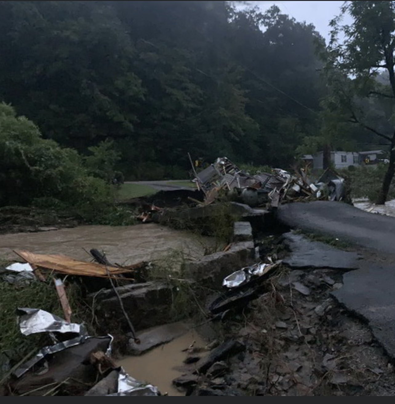
0210 AM Flash Flood 4 N Avawam 37.27N 83.28W
07/28/2022 Perry KY Public
Pictures on social media show stream
crossing along KY-451 collapsed between Busy
and Little Willard due to flash flooding.
The debris flow ended up in a yard nearby.
Time estimated.
0213 AM Flash Flood 2 WNW Hazard 37.27N 83.23W
07/28/2022 Perry KY Public
Report from mPING: Homes, buildings or
vehicles swept away.
0217 AM Flash Flood Waldo 37.57N 82.98W
07/28/2022 Magoffin KY 911 Call Center
Magoffin County dispatch reports water
entering home at the intersection of Trace
Rd. and Trace Fork (KY-542 and KY-1502).
0230 AM Flash Flood 1 E Spider 37.26N 82.91W
07/28/2022 Knott KY Public
House destroyed and carried onto Steer Fork
Road and KY-582 by flash flood waters. Time
estimated.
0300 AM Flash Flood Fisty 37.33N 83.10W
07/28/2022 Knott KY Public
Homes on lower side of KY-550 in Fisty swept
away by flash flooding along the Troublesome
Creek. Time estimated.
0300 AM Flash Flood Glo 37.44N 82.81W
07/28/2022 Floyd KY Public
Picture shows single wide trailer floated
across Mill Creek Rd bridge and wedged
against the guard rail by flash flood
waters. Time estimated.
0300 AM Flash Flood 1 NNE Hindman 37.34N 82.98W
07/28/2022 Knott KY Trained Spotter
Patriot Dairy Bar destroyed by flash
flooding.
0300 AM Flash Flood Hindman 37.33N 82.99W
07/28/2022 Knott KY Fire Dept/Rescue
Fire truck from the Hindman Volunteer FD
swept and pinned underneath the Cowtown Rd
bridge over Troublesome Creek. Time
estimated.
0300 AM Flash Flood Pippa Passes 37.34N 82.87W
07/28/2022 Knott KY Public
Picture on social media shows car pinned
under the pedestrian bridge in front of
Alice Lloyd College by flash flood waters.
Time estimated.
0300 AM Flash Flood 1 SSE Ned 37.40N 83.27W
07/28/2022 Perry KY Public
Pictures on social media show multiple homes
swept away by flash flood along Lost Creek
adjacent to the intersection of KY-15 and
Lost Creek-Dice Rd. Time estimated.
0300 AM Flash Flood 2 NW Jonancy 37.33N 82.61W
07/28/2022 Pike KY Public
Submerged car in stream and significant road
damage reported in the Long Fork area of
Virgie. Event time estimated.
0300 AM Flash Flood Hindman 37.33N 82.98W
07/28/2022 Knott KY Broadcast Media
Catastrophic flash flooding in the city of
Hindman. Event onset time estimated.
0300 AM Flash Flood Hindman 37.34N 82.98W
07/28/2022 Knott KY Public
Picture on social media showed Hidden
Treasure Shop along E Main Street (KY-550)
in Hindman severely damaged by flash flood
waters from Troublesome Creek. Time
estimated.
0308 AM Flash Flood Campton 37.73N 83.55W
07/28/2022 Wolfe KY Public
Seven to 8 inches of flowing water reported
for a second time overnight on Main Street
in in front of Sweet Arts.
0311 AM Flash Flood Campton 37.73N 83.55W
07/28/2022 Wolfe KY Trained Spotter
7-8 inches of water flowing over Drake Road
in Campton.
0322 AM Flash Flood 1 WNW Pine Top 37.28N 82.90W
07/28/2022 Knott KY Public
Video on social media shows the Pine Top
Post Office was two thirds submerged by
significant flash flood waters along Carr
Fork.
0325 AM Flash Flood Salyersville 37.75N 83.07W
07/28/2022 Magoffin KY 911 Call Center
Law enforcement reports KY route 7
impassible in many locations due to flash
flooding.
0327 AM Flash Flood Buckhorn 37.35N 83.47W
07/28/2022 Perry KY Public
Pictures posted to social media show
significant flash flooding through the
Buckhorn School.
0327 AM Flash Flood 1 WNW Pine Top 37.28N 82.89W
07/28/2022 Knott KY Broadcast Media
Highway 582 is flooded. Water is three
quarters of the way up the post office
building in Pine Top.
0330 AM Flash Flood Emmalena 37.33N 83.08W
07/28/2022 Knott KY Public
Camp Nathanael sustained significant damage
to several structures. Event start time
estimated.
0330 AM Flash Flood 1 S Ary 37.37N 83.15W
07/28/2022 Perry KY Public
Robinson Elementary School at Ary was
completely inundated by flash flood waters
from Troublesome Creek. Time estimated.
0330 AM Flash Flood 1 SSW Ary 37.37N 83.15W
07/28/2022 Perry KY Public
Pigeonroost-Bulan Rd inundated near KY-476
intersection by flash flooding from
Troublesome Creek. Time estimated.
0340 AM Flash Flood Buckhorn 37.35N 83.47W
07/28/2022 Perry KY Trained Spotter
Buckhorn school is flooded. Nearby squabble
creek is out of its banks.
0344 AM Flash Flood Emmalena 37.34N 83.08W
07/28/2022 Knott KY Trained Spotter
Multiple cars submerged and house surrounded
by water in Emmalena. Report via social
media.
0400 AM Flash Flood 2 NW Brutus 37.27N 83.60W
07/28/2022 Clay KY Newspaper
Newspaper indicates multiple reports of
flash flooding in the Little Bullskin area
near Oneida. Vague reports of flooding also
found on social media. Time estimated.
0400 AM Flash Flood Mill Pond 37.23N 83.73W
07/28/2022 Clay KY Newspaper
Bridge at Skull Branch reported washed out
at 9 AM. Time of occurrence likely after 4
AM. Flash flooding onset time estimated.
0408 AM Flash Flood Canoe 37.45N 83.45W
07/28/2022 Breathitt KY Public
Joe Little Fork Rd. reportedly received a
second flash flood.
0415 AM Flash Flood 2 NW Myra 37.31N 82.64W
07/28/2022 Pike KY Public
2 feet of water across long fork road in
Virgie.
0418 AM Flash Flood Oneida 37.27N 83.65W
07/28/2022 Clay KY Public
RV reportedly washed away along Booneville
Road near Oneida.
0420 AM Flash Flood 2 ENE Littleton 37.17N 83.72W
07/28/2022 Clay KY Newspaper
Newspaper reported that Beech Creek Rd. at
the Bert T. Combs campground was closed due
to flooding. Onset time estimated.
0430 AM Flash Flood 2 NE Shelby Gap 37.23N 82.53W
07/28/2022 Pike KY Public
Elkhorn Creek was reported out of its banks
and flood waters were threating homes along
the creek. Residents in the area were
evacuating multiple homes south of KY 197
around 430 AM EDT.
0436 AM Flash Flood Jetts Creek 37.50N 83.55W
07/28/2022 Breathitt KY Public
Flash Flooding observed along Jetts Creek
Rd.
0540 AM Flash Flood Panco 37.24N 83.53W
07/28/2022 Clay KY Public
The culvert for KY-1482 over Panco branch at
the intersection of Panco Drive washed away.
Time estimated.
0600 AM Flash Flood Isom 37.19N 82.91W
07/28/2022 Letcher KY Public
Isom IGA inundated to above the doorway by
flash flooding along Rockhouse Creek.
0620 AM Flash Flood Whitesburg 37.12N 82.82W
07/28/2022 Letcher KY Public
A picture showed the Appalshop at Whitesburg
inundated by flash flood waters. Event onset
time assumed to be when moderate flood stage
was exceeded at the Whitesburg gauge along
the North Fork Kentucky River.
0630 AM Flash Flood Whitesburg 37.12N 82.82W
07/28/2022 Letcher KY Public
A picture showed several feet of flash flood
water rushing down E Main Street (KY-15) in
front of the Railroad Street Mercantile of
downtown Whitesburg. Event onset time
assumed when major flood stage was exceeded
at the Whitesburg gauge along the North Fork
Kentucky River.
0700 AM Flash Flood Oven Fork 37.06N 82.80W
07/28/2022 Letcher KY Public
Flash Flooding reported at 8:12 AM along
US-119 between JD Maggard Store and the
Upper FD. Start time estimated from radar.
0700 AM Flash Flood 1 WNW Hardshell 37.46N 83.27W
07/28/2022 Breathitt KY Public
Picture on social media shows two homes
caught in flash flood waters at Nobles
Landing along Troublesome Creek. Time of
event onset estimated.
0930 AM Flood Glo 37.45N 82.81W
07/28/2022 Floyd KY Public
Picture shows Marathon gas station along
KY-7 (Main Street) in Wayland inundated by
flood waters. Fuel pumps were completely
submerged. Time estimated.
0953 AM Flood 1 W Jackson 37.56N 83.39W
07/28/2022 Breathitt KY Public
Kiwanis Park in Jackson inundating by the
North Fork Kentucky River.
1000 AM Flood Lee City 37.74N 83.33W
07/28/2022 Wolfe KY Public
Red River flooding across KY-205 at Lee
City.
1016 AM Flood Canoe 37.45N 83.45W
07/28/2022 Breathitt KY Public
Church and home at intersection of Joe
Little Fork and KY-3237 inundated by flood
waters of Joe Little and Canoe creeks.
1100 AM Flood 1 W Hardshell 37.46N 83.26W
07/28/2022 Breathitt KY Public
Picture shows Old Caney school surrounded by
Troublesome Creek flood waters up to the
second story. Time estimated.
1119 AM Flood 1 W Jackson 37.56N 83.40W
07/28/2022 Breathitt KY Public
Douthitt Park ball field inundated with
several feet of water from the North Fork
Kentucky River.
1126 AM Flood Lost Creek 37.48N 83.32W
07/28/2022 Breathitt KY Public
Lost Creek Evangelical Free Church along
KY-476 inundated by Troublesome Creek to
within a couple feet of the roof.
1158 AM Flood Krypton 37.31N 83.34W
07/28/2022 Perry KY Public
KY-451 inundated by the North Fork Kentucky
River and Campbell Creek at Krypton.
1221 PM Flood 1 NNE Howard Creek 37.48N 83.37W
07/28/2022 Breathitt KY Public
KY-397 and KY-1110 intersection inundated by
the North Fork Kentucky River.
1238 PM Flood Hazel Green 37.80N 83.42W
07/28/2022 Wolfe KY Public
Several inches of standing water from the
Red River in the Wolfe County Animal
Shelter.
1240 PM Flood Flintville 37.48N 83.30W
07/28/2022 Breathitt KY Public
Homes along KY-476 near intersection with
KY-15 inundated half way up the first story
by Troublesome Creek.
0126 PM Flood Lost Creek 37.48N 83.32W
07/28/2022 Breathitt KY Public
Homes at Lost Creek community as well as the
Riverside School campus inundated by flood
waters from Troublesome and Lost creeks.
0128 PM Flood 1 S Kettle Island 36.78N 83.61W
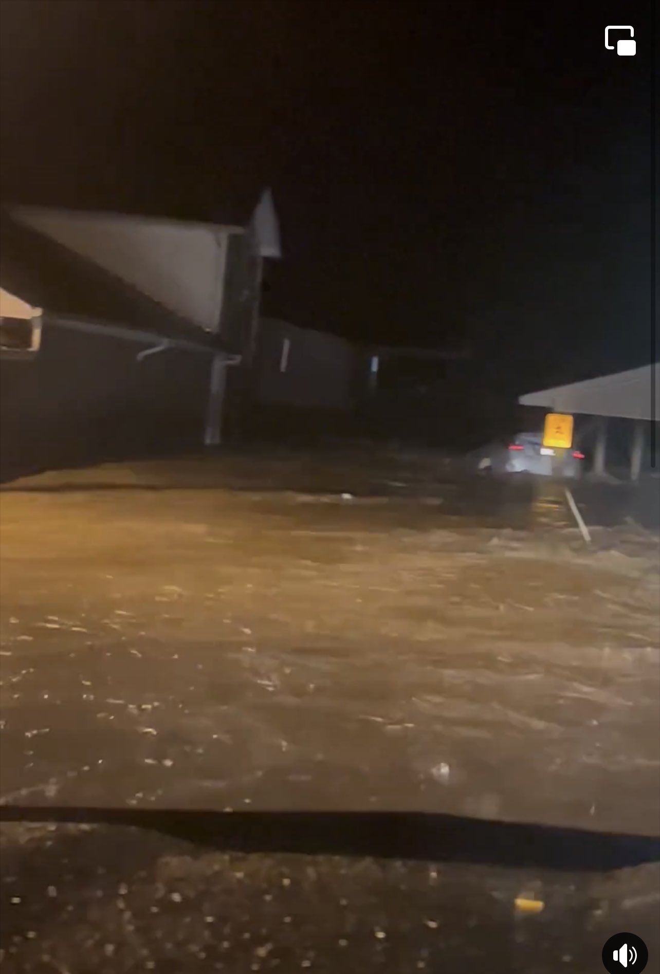
07/28/2022 Bell KY Public
Video footage shows Straight Creek flooding
onto Old Jensen Road in Bell County.
0155 PM Flood 1 WSW Isom 37.18N 82.91W
07/28/2022 Letcher KY Public
Isom IGA/Subway and adjacent businesses
inundated by several feet of flood water.
0200 PM Flood 2 NW Canoe 37.47N 83.47W
07/28/2022 Breathitt KY Public
Picture shows Canoe Road inundated by the
Middle Fork of the Kentucky River. Time
estimated.
0246 PM Flood Whitesburg 37.12N 82.83W
07/28/2022 Letcher KY Broadcast Media
Pictures from media show SKCTC campus
inundated by the North Fork Kentucky River.
Water level half way up the first-story
windows on at least one campus building.
0300 PM Flood Chavies 37.34N 83.35W
07/28/2022 Perry KY Broadcast Media
Pictures from broadcast media show flood
waters of North Fork Kentucky River
inundating the intersection of KY-458 and
KY-28 just outside of Chavies. Time
estimated.
0300 PM Flood 1 NNE Howard Creek 37.48N 83.37W
07/28/2022 Breathitt KY Public
Pictures show electric substation at the
intersection of KY-397 and KY-1110 inundated
by the North Fork Kentucky River. Time
estimated.
0309 PM Debris Flow 1 SW Teges 37.29N 83.68W
07/28/2022 Clay KY Dept of Highways
KYTC reported a debris flow onto KY-11 near
MP 22 in Clay County.
0336 PM Flood Quicksand 37.54N 83.35W
07/28/2022 Breathitt KY Public
KY-1098 submerged at intersection of KY-15
by Quicksand Creek flood waters.
0338 PM Flood 1 SSW Jackson 37.55N 83.38W
07/28/2022 Breathitt KY Public
Video footage shows South Jackson inundated
by the North Fork Kentucky River.
0414 PM Flood 1 SE Bosco 37.50N 82.83W
07/28/2022 Floyd KY Public
Video footage shows water rescue by Route 7
bridge near Maddys Pizza in Ary.
0500 PM Flood 1 SE Bosco 37.50N 82.83W
07/28/2022 Floyd KY Public
Picture on social media shows water up to
the windows on trailer homes in Hueysville.
Time estimated.
0500 PM Flood 1 W Jackson 37.56N 83.39W
07/28/2022 Breathitt KY Public
North Fork Kentucky River begins inundating
Slones Trailer Park at Jackson.
0511 PM Flood 1 S Fivemile 37.57N 83.40W
07/28/2022 Breathitt KY Public
Horse barn submerged to its roof at
Wolverine by the North Fork Kentucky River.
0519 PM Flood Garret 37.48N 82.84W
07/28/2022 Floyd KY Public
Garrett community inundated by several feet
of flood water from Right Fork Beaver Creek.
0728 PM Flood Martin 37.57N 82.76W
07/28/2022 Floyd KY Fire Dept/Rescue
Martin Fire Department reported flood water
over Brawley Street in Martin.
0756 PM Flood Hazard 37.25N 83.20W
07/28/2022 Perry KY Broadcast Media
WYMT photo shows flood waters from the North
Fork Kentucky River inundating North Main
Street near the intersection with Y Street.
0200 AM Flash Flood Inez 37.87N 82.53W
07/29/2022 Martin KY Public
Video posted on social media showing the
aftermath of flash flooding along Main
Street in Inez. The creek exceeded its banks
and came into town, with mud residue clearly
seen on the roads, sidewalks and in the
storefront parking lots. Time estimated.
0810 AM Flood Jackson 37.55N 83.39W
07/29/2022 Breathitt KY Public
Pictures show widespread inundation in
downtown Jackson at the intersection of
Broadway and Hawk Street.
0911 AM Flood Elkatawa 37.56N 83.42W
07/29/2022 Breathitt KY Public
Pictures on social media show flood waters
surrounding the Elkatawa Free Methodist
Church. KY-52 inundated.
1025 AM Flood 1 WNW Jackson 37.57N 83.40W
07/29/2022 Breathitt KY Public
Jackson Save A Lot and Tractor Supply Co.
inundated by the North Fork Kentucky River.
1047 AM Flood 1 W Jackson 37.56N 83.39W
07/29/2022 Breathitt KY Public
Pictures show North Fork Kentucky River
inundating the Slones Trailer Park up to the
windows of a car.
1155 AM Flash Flood Callaway 36.78N 83.57W
07/29/2022 Bell KY 911 Call Center
Bell County dispatch reports that Balkan Rd
off of US 119 was closed due to high water.
1247 PM Flash Flood Three Point 36.76N 83.26W
07/29/2022 Harlan KY 911 Call Center
Report of flash flooding taking place in
Three Points, KY off of Hwy 991 just south
of Cawood, KY.
0113 PM Flash Flood 1 WSW Ponza 36.71N 83.67W
07/29/2022 Bell KY Public
Pictures on social media show minor flash
flooding and debris along Page Cutoff Road.
1147 PM Flood Proctor 37.57N 83.71W
07/29/2022 Lee KY Public
West Main Street covered with flood water at
the RR underpass. Water also over Lumber
street near the Valero gas station.
 |
Media use of NWS Web News Stories is encouraged! Please acknowledge the NWS as the source of any news information accessed from this site. |
|


.png)