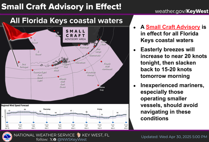
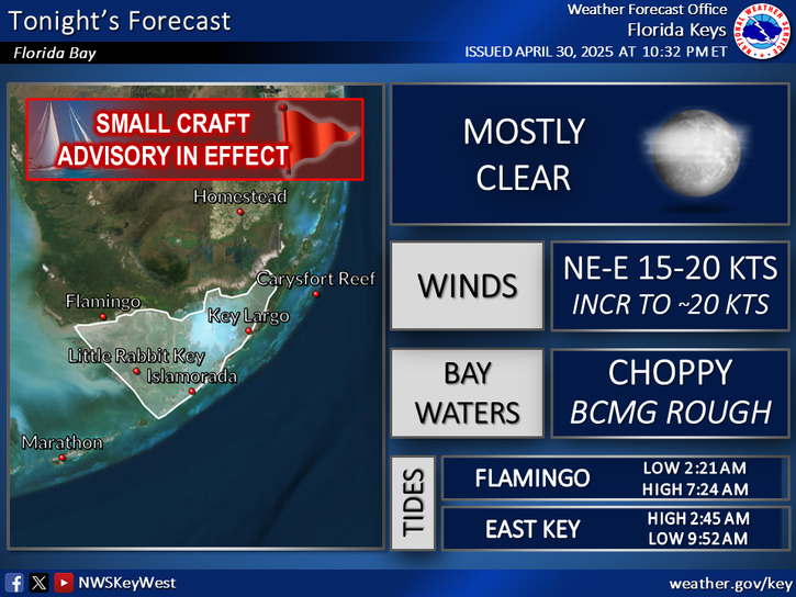
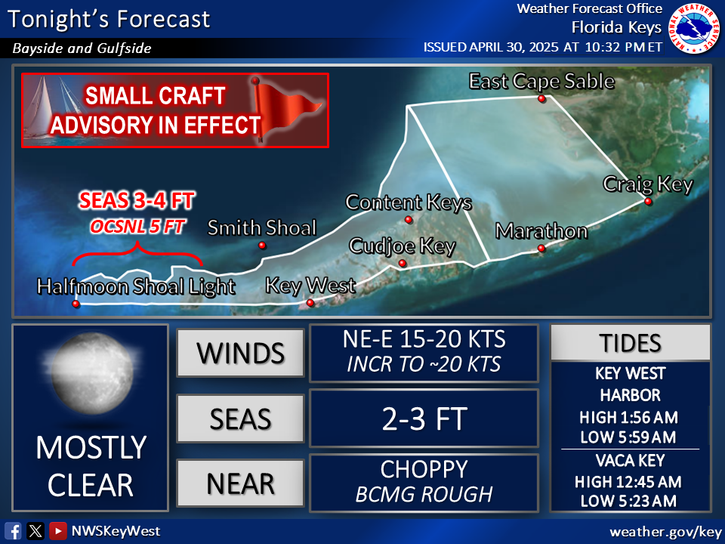
National Weather Service United States Department of Commerce

Severe Thunderstorms and Heavy Rainfall Threats

A stationary frontal boundary will focus heavy rainfall and isolated severe thunderstorms across central and south Florida Peninsula through Tuesday. Meanwhile, a slow moving frontal boundary will move across the center of the nation with threats of heavy rainfall, severe weather and gusty winds from the Four-Corners region into the upper Midwest through Tuesday evening. Read More >

Click a location below for detailed forecast.

Last Map Update: Mon, Jun 2, 2025 at 9:18:20 am EDT

A frontal boundary will stall north of the Island Chain today.

This will lead to a prolonged rain event with the heaviest rainfall expected between today and Tuesday night.

Rainfall totals of 3-6 inches over the next several days with locally higher amounts possible.

Localized minor flooding will be possible, especially between this evening and Tuesday night.

Rainfall amounts should begin to taper by Wednesday afternoon.
TODAY...Showers with thunderstorms likely. Locally heavy rainfall possible. Highs in the upper 80s. South to southwest winds near 10 mph, becoming southeast to south and briefly decreasing to 5 to 10 mph in the afternoon. Chance of rain 80 percent.
TODAY...South to southwest winds near 10 knots, briefly decreasing to 5 to 10 knots in the afternoon. Bay waters a light chop, becoming smooth to a light chop. Bay waters rough and winds higher in and around widespread showers and numerous thunderstorms.
TODAY...South to southwest winds near 10 knots, becoming southeast to south and briefly decreasing to 5 to 10 knots. Seas around 1 foot. Nearshore waters a light chop, becoming smooth to a light chop. Winds and seas higher in and around widespread showers and numerous thunderstorms.
TODAY...South to southwest winds near 10 knots, becoming southeast and briefly decreasing to 5 to 10 knots in the afternoon. Seas around 1 foot. Nearshore waters a light chop, becoming smooth to a light chop. Winds and seas higher in and around widespread showers and numerous thunderstorms.
TODAY...South to southwest winds 10 to 15 knots, becoming southeast to south and briefly decreasing to near 10 knots in the afternoon. Seas 1 to 2 feet. Wave Detail: Southeast to south 1 foot at 3 seconds and west to northwest 1 foot at 5 seconds. Winds and seas higher in and around widespread showers and numerous thunderstorms.
TODAY...South to southwest 5 to 10 knots, becoming becoming northeast to east and briefly decreasing to near 5 knots in the afternoon. Seas around 1 foot. Wave Detail: South 1 foot at 2 seconds and west to northwest 1 foot at 4 seconds. Winds and seas higher in and around widespread showers and numerous thunderstorms.


Text Product Selector
(Selected product opens in a new window) 


Sunrise & Sunset

Sunrise & Sunset


Moon Rise & Set

Moon Rise & Set


Moon Illumination

Moon Illumination


Tide Information

Tide Information


Tropical

Tropical


Coastal Flooding

Coastal Flooding


Tallship

Marine


Nearshore Waves

Wave Prediction


Thumbnail for a local waterspouts website, showing 4 waterspouts.

Waterspouts


Airplane

Aviation


Key West & Marathon Climographs 2020

Climographs


Tropical

Forecast Discussion


NOAA Weather Radio

NOAA Weather Radio