|
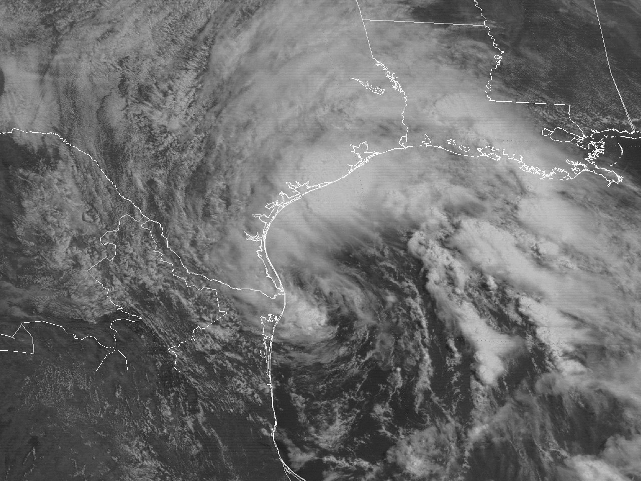
Above: GOES-7 visible satellite image of Tropical Storm Arlene off the Lower Texas coast at 11:01 AM CDT June 19, 1993.
The origin of Tropical Storm Arlene can be traced back to the interaction of a tropical wave and a large area of disturbed weather over the Yucatán Peninsula on June 16th. Air force reconnaissance aircraft investigated the disturbance midday on June 17th and only found a broad area of low pressure. Later that evening, convective banding and increased organization prompted the issuance of advisories on Tropical Depression #2.
The mid to upper level pattern was dominated by a large ridge of high pressure over the Southeastern United States and a mid to upper level low across the far Southwest Gulf. The tropical depression remained just northeast of the mid to upper low, with a slow northwest motion and moderate southwesterly wind shear over the depression. The shear, and the broad circulation of the depression with multiple vortices, limited development through June 18th.
Convection became more dominate about 200 miles to the northwest of the center during the early morning hours of June 19th. By daybreak, reconnaissance aircraft, GOES satellite, Brownsville, Texas National Weather Service WSR-57 radar and buoy data confirmed the reformation of a dominate new center around 85 miles east of Brownsville, Texas. Also, with minimal tropical storm force winds detected at the surface by the aircraft and buoys, the system was upgraded to Tropical Storm Arlene at 7 AM CDT. A GOES-7 visible satellite image at 11:01 AM CDT June 19th shows the continued large cloud envelop of Tropical Storm Arlene spreading deep convection across the Northwest Gulf, the eastern half of Texas, and most of Louisiana.
The mid to upper low over the Southwest Gulf gradually filled, leaving with very weak steering currents between two large mid to upper level ridges of high pressure over Mexico and the Southeast United States. This caused Tropical Storm Arlene to move very slowly to the northwest around 3 to 5 mph for the remainder of June 19th through the morning hours of June 20th. The center of Arlene made landfall on Padre Island about 45 miles south of Corpus Christi, Texas around 4 AM CDT June 20th with maximum sustained winds of 40 mph (35 knots) and a minimum sea level pressure of 1000 millibars (29.53 inches). Arlene was downgraded to a depression 3 hours later near Kingsville, Texas. Steering currents weakened further, and Tropical Depression Arlene stalled for the remainder of the day through early on June 21st, with the low-level center dissipating by daybreak. The stalled remnants of Arlene continued through June 22nd. Click here for an interactive track of Tropical Storm Arlene.
WIND & PRESSURE:
No sustained winds of tropical storm force were recorded along the coasts or inland areas of Texas or Louisiana. Sustained winds of 20 to 25 mph with gusts 30 to 35 mph were common with the passing squalls. Sustained winds of tropical storm force were recorded across several oil and gas production platforms across the Northwest Gulf. Higher winds typically occur on these platforms, since most are typically around 75 to over 100 feet above the water. For complete meteorological statistics, see the Wind and Pressure section. For complete meteorological statistics, see the Wind and Pressure section.
STORM SURGE:
Tides of 3 to 5 feet MSL occurred along the middle and upper Texas coast, with 2 to 3 feet MSL across the Lower Texas coast. For other storm surge and high-water marks, see the Storm Surge section.
RAINFALL:
Due to the large circulation and slow movement of Tropical Storm Arlene, heavy rainfall of 7 to 10 inches occurred along and north of I-10 across Southwest Louisiana to Southeast Texas, and averaged between 2 to 6 inches across Central and portions of South-Central Louisiana. The highest storm total across our region was 10.91 inches in Crowley, Louisiana. For complete rainfall totals reported across our region, see the Rainfall section.
TORNADOES:
No tornadoes were reported across Texas and Louisiana.
|


