National Weather Service United States Department of Commerce
Click a location below for detailed forecast.

Last Map Update: Fri, Apr 3, 2026 at 2:26:28 pm CDT

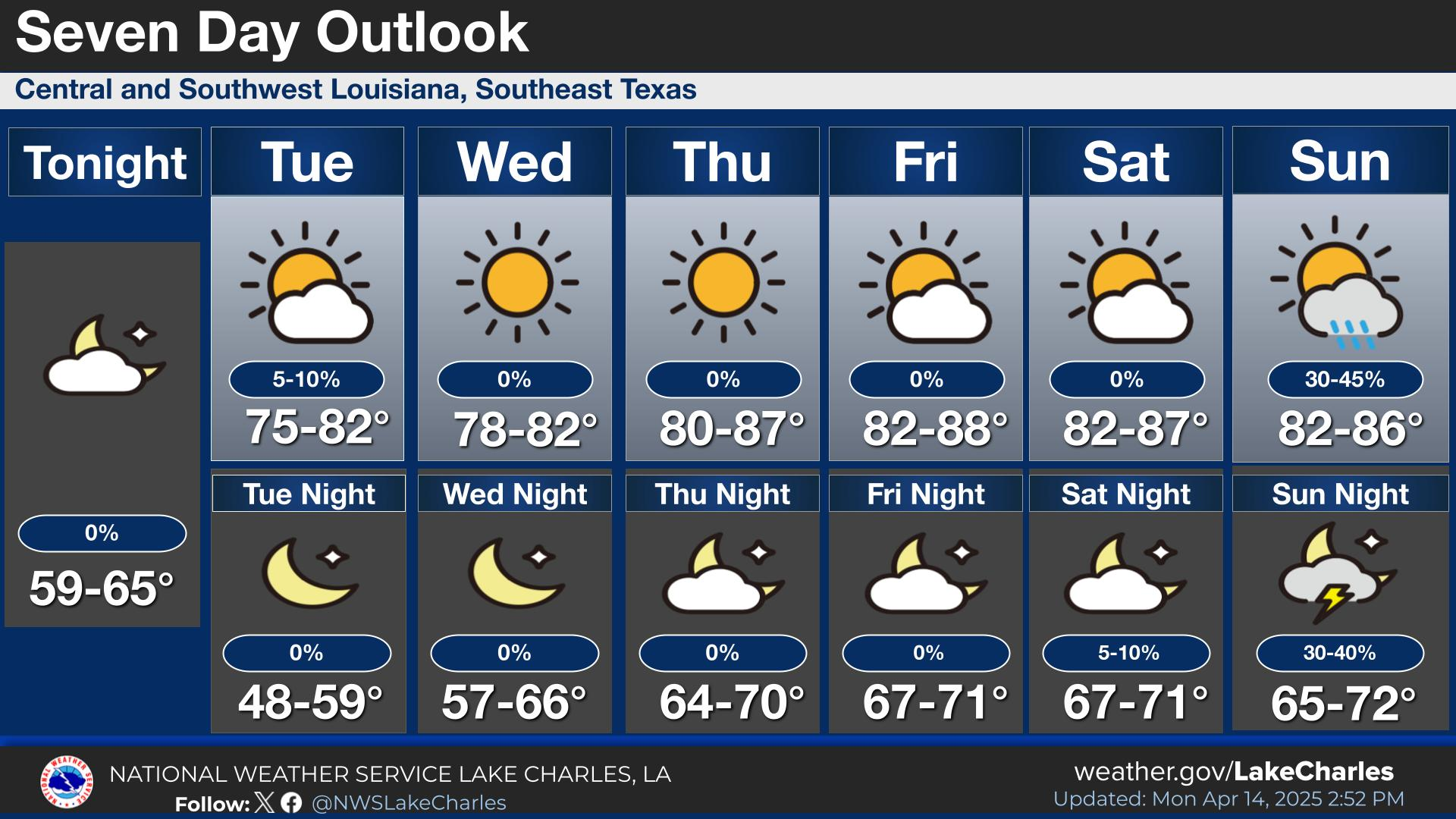
A warm, tropical air mass will remain in place until a cold front moves through Saturday night into early Easter Sunday morning. Showers and thunderstorms will develop ahead of and along the front. There is a small risk that storms will have the potential to become severe with damaging wind gusts, large hail, and a quick spin up tornado. Also, there is a small risk that the storms will produce heavy rainfall that may lead to urban type flooding. Cooler and drier weather will move in behind the front for early next week before conditions warm up again by mid week.
A cold front will push through the region late Saturday afternoon through the evening hours, accompanied by showers and thunderstorms. A couple of these storms could become strong to severe.
A cold front will move into a very moist air mass Saturday into Saturday night producing showers and thunderstorms capable of heavy rainfall. Slow moving and/or training thunderstorms will have the potential to cause localized street flooding.
A warm, tropical air mass will remain in place through Friday, bringing isolated showers and thunderstorms to the region. Rain chances increase for Saturday into Easter Sunday as a cold front moves through the area.
Breezy onshore winds will continue through Saturday with showers and thunderstorms expected Friday afternoon. A cold front will push through the coastal waters Saturday night into early Sunday accompanied by showers and thunderstorms. Strong northerly winds will develop behind the front Sunday into Sunday night. A Small Craft Advisory will likely be issued for this time frame later this week.

Latest Text Product Selector
 
 
Hourly Weather Roundup ( )
Location Sky/Weather Temp Dewpt RH Wind Baro Remarks
Lake Charles
N/A
N/A
N/A
N/A
N/A
N/A
N/A
Abbeville
N/A
N/A
N/A
N/A
N/A
N/A
N/A
Alexandria
N/A
N/A
N/A
N/A
N/A
N/A
N/A
Beaumont
N/A
N/A
N/A
N/A
N/A
N/A
N/A
De Quincy
N/A
N/A
N/A
N/A
N/A
N/A
N/A
De Ridder
N/A
N/A
N/A
N/A
N/A
N/A
N/A
Fort Polk
N/A
N/A
N/A
N/A
N/A
N/A
N/A
Jasper
N/A
N/A
N/A
N/A
N/A
N/A
N/A
Jennings
N/A
N/A
N/A
N/A
N/A
N/A
N/A
Lafayette
N/A
N/A
N/A
N/A
N/A
N/A
N/A
Nederland/Port Arthur
N/A
N/A
N/A
N/A
N/A
N/A
N/A
New Iberia
N/A
N/A
N/A
N/A
N/A
N/A
N/A
Oakdale
N/A
N/A
N/A
N/A
N/A
N/A
N/A
Opelousas
N/A
N/A
N/A
N/A
N/A
N/A
N/A
Orange
N/A
N/A
N/A
N/A
N/A
N/A
N/A
Patterson
N/A
N/A
N/A
N/A
N/A
N/A
N/A
Pineville
N/A
N/A
N/A
N/A
N/A
N/A
N/A
Sulphur/Carlyss
N/A
N/A
N/A
N/A
N/A
N/A
N/A
"N/A" or "MISG" will be displayed if values are not available. In the LOCATION column, click on links for a list of recent observations at sites of interest. In the WIND column, VRB is "variable" and G is "gust". Wind speeds are in MPH. In the BARO (pressure) column, values are in inches. In the REMARKS column, HX is "heat index", WCI is "wind chill index", and VSB is "visibility" (if shown).
 

Current Weather
 
Rivers & Lakes
 
Forecast Maps
 
Hour By Hour Forecast
 
Tropical Weather
 
Marine Forecast
 
Text Bulletins
 
Forecast Discussion
 
NOAA Weather Radio
 
Submit Storm Report