
Severe thunderstorms capable of damaging winds will be possible from the Ozark Plateau east into portions of the Southeast today. Rounds of heavy thunderstorms ahead of a slow moving front will continue locally heavy rainfall and scattered flash flooding potential from the Ozarks to the Ohio and Tennessee Valleys today. Read More >
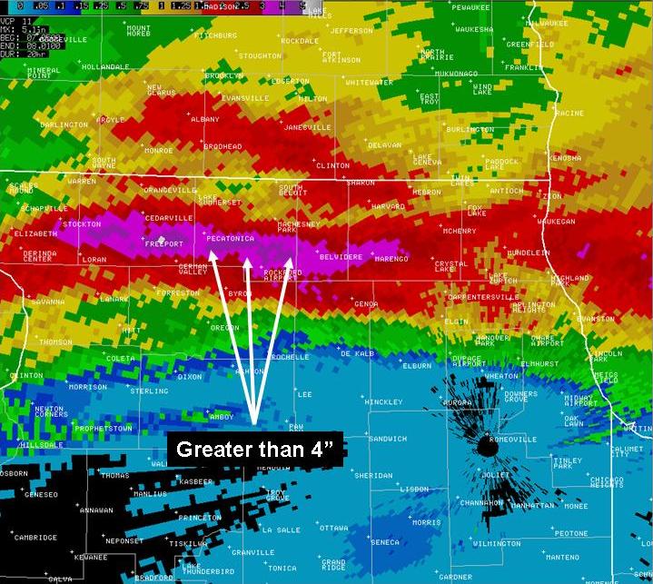
Rainfall
Heavy rain fell across northern Illinois during the early morning hours of Tuesday August 7, 2007.
Rainfall of 3 to 7 inches was reported in parts of Winnebago, Boone, McHenry, Lake, Ogle, northern Dekalb,
northern Kane, and northern Cook Counties. The heaviest rain was centered around the city of Rockford
where widespread flooding of homes and businesses occurred. Nearly 7 inches of rain was reported within
the southeast side of Rockford. It would appear that the most intense rain fell between midnight and 4 AM.
Flooding
Flooding was extensive along Keith Creek on the southeast side of Rockford. The Cherry Valley area also
experienced significant flooding. Elsewhere, the heavy rain led to flooding on small creeks within Boone
and McHenry counties. The Kishwaukee River flooded a campground and other areas in Boone county.
The following image depicts estimated rainfall amounts from the Chicago WSR-88D Doppler Radar
Rainfall Reports in the Rockford Area
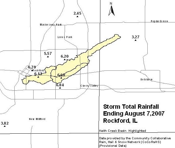
Here is a list of rainfall amounts for the 24 hour period ending 700 AM Tuesday August 7.
Reports are from NWS Cooperative Observers, CoCoRaHs volunteer reporting network, spotters, and official NWS observations:
FREEPORT 3.5N............... 7.00
ROCKFORD 3.0SE.............. 6.84
ROCKFORD 0.7NW.............. 6.79
ROCKFORD 2.4ESE............. 6.60
BELVIDERE................... 6.30
ROCKFORD 3.3NE.............. 6.20
ROCKFORD 0.4S............... 6.13
ROCKFORD 4NW................ 5.78
LOVES PARK 2.8SW............ 5.57
MARENGO..................... 5.54
ROCKFORD AIRPORT............ 5.25
GENOA 1.7N.................. 4.62
WOODSTOCK................... 4.35
MCHENRY..................... 4.19
LAKE FOREST 2.1NNE.......... 4.16
CRYSTAL LAKE................ 4.05
NEW MILFORD................. 3.82
GENOA....................... 3.75
HUNTLEY..................... 3.67
LAKE BLUFF 1.3W............. 3.57
LAKE BLUFF 0.6SW............ 3.49
MOUNT PROSPECT 3.0NE........ 3.31
POPLAR GROVE 3.2SW.......... 3.27
GRAYSLAKE 0.7WSW............ 3.23
BYRON 3.2N.................. 3.12
WAUCONDA.................... 3.12
LIBERTYVILLE 1.6SE.......... 3.11
FOX RIVER GROVE............. 2.91
GURNEE...................... 2.73
LAKE ZURICH................. 2.72
BARRINGTON.................. 2.70
MUNDELEIN................... 2.68
The National Weather Service Chicago office would like to thank all the NWS Cooperative Observers, CoCoRaHS observers, and spotters for their timely rainfall reports during this significant flood event.

