Widespread life-threatening flash and urban flooding continues in south-central Texas, with considerable flooding impacts possible across central Texas. Wildfire smoke is impacting air quality across much of the Great Lakes region into southern New England and the Mid-Atlantic. Monsoonal thunderstorms may produce isolated to scattered flash flooding across the Southwest into the Great Basin. Read More >
Overview
|
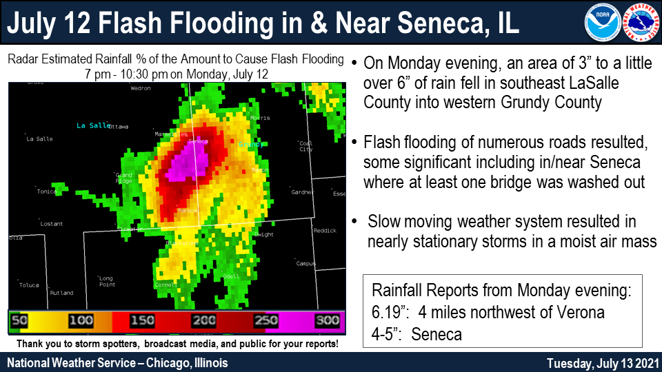
Fast Facts:
For detailed information about this event, see Analysis of the July 12-13, 2021, Flash flood near Seneca, IL, a NWS Technical Paper detailing the rainfall, flooding, and impacts. |
|
Flooding & Heavy Rain Reports
PRELIMINARY LOCAL STORM REPORT...SUMMARY
NATIONAL WEATHER SERVICE CHICAGO IL
201 AM CDT TUE JUL 13 2021
..TIME... ...EVENT... ...CITY LOCATION... ...LAT.LON...
..DATE... ....MAG.... ..COUNTY LOCATION..ST.. ...SOURCE....
..REMARKS..
0247 PM TSTM WND DMG ASHKUM 40.88N 87.96W
07/12/2021 IROQUOIS IL PUBLIC
SEVERAL BRANCHES DOWNED ALONG U.S. HIGHWAY
45.
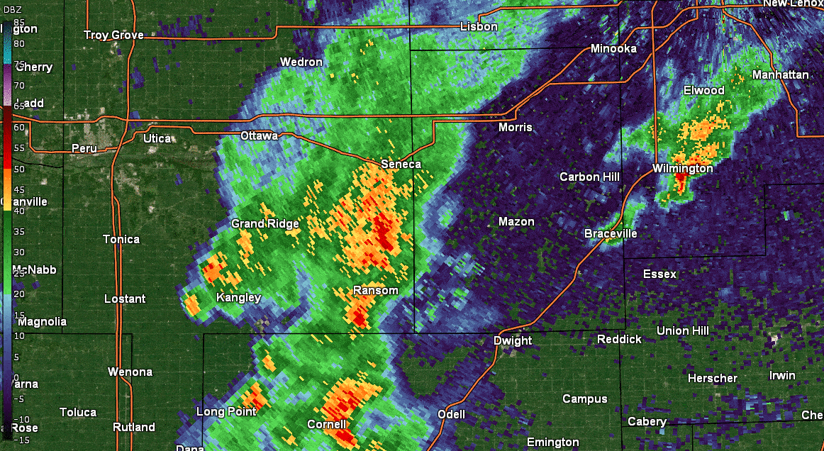
0955 PM FLASH FLOOD 3 N KINSMAN 41.24N 88.57W
07/12/2021 GRUNDY IL TRAINED SPOTTER
OVER ONE FOOT OF WATER FLOWING OVER THE
ROADWAY AT THE INTERSECTION OF S KINSMAN AND
W GRAND RIDGE ROADS.
1019 PM HEAVY RAIN 4 NW VERONA 41.25N 88.55W
07/12/2021 M6.19 INCH GRUNDY IL MESONET
3 HOUR RAINFALL TOTAL OF 6.19 INCHES FROM A
PERSONAL WEATHER STATION.
1030 PM FLASH FLOOD 3 NW KINSMAN 41.22N 88.61W
07/12/2021 LA SALLE IL LAW ENFORCEMENT
WATER OF A FOOT OVER ILLINOIS HIGHWAY 170.
THIS WAS CONTINUING AT 1 A.M. ON JULY 13 BUT
LIKELY BEGAN MUCH EARLIER. TIME ESTIMATED BY
RADAR.
1034 PM HEAVY RAIN 1 E SENECA 41.31N 88.60W
07/12/2021 M4.24 INCH LA SALLE IL MESONET
3-HOUR RAINFALL TOTAL OF 4.24 INCHES FROM A
PERSONAL WEATHER STATION IN SENECA.
1038 PM FLASH FLOOD 1 ESE SENECA 41.30N 88.58W
07/12/2021 GRUNDY IL FIRE DEPT/RESCUE
WATER RESCUES PERFORMED AT THE INTERSECTION
OF DUPONT AND KINSMAN RD. AT LEAST 3
VEHICLES STUCK IN THE FLOODED ROADWAY.
1039 PM HEAVY RAIN 3 E SENECA 41.30N 88.56W
07/12/2021 M4.58 INCH GRUNDY IL MESONET
4-HOUR RAINFALL TOTAL OF 4.58 INCHES FROM A
PERSONAL WEATHER STATION.
1056 PM FLASH FLOOD 1 S SENECA 41.30N 88.61W
07/12/2021 LA SALLE IL FIRE DEPT/RESCUE
BRIDGE PARTIALLY WASHED OUT ON RIVER ROAD
JUST WEST OF IL 170. RELAYED VIA SOCIAL
MEDIA.
1150 PM FLASH FLOOD 2 ESE SENECA 41.29N 88.57W
07/12/2021 GRUNDY IL TRAINED SPOTTER
SEVERAL INCHES OF WATER RUSHING OVER KINSMAN
ROAD DUE TO RISING WATER IN ARMSTRONG RUN.
1215 AM FLOOD BRACEVILLE 41.23N 88.27W
07/13/2021 GRUNDY IL TRAINED SPOTTER
6 TO 8 INCHES OF STANDING WATER IN YARDS ON
THE NORTH SIDE OF BRACEVILLE.
1230 AM HEAVY RAIN 1 SSW COAL CITY 41.28N 88.29W
07/13/2021 M1.57 INCH GRUNDY IL MESONET
MOST OF THIS FELL BETWEEN 10:30 PM AND 12:30
AM.
0115 AM FLASH FLOOD 2 SE SENECA 41.29N 88.58W
07/13/2021 GRUNDY IL TRAINED SPOTTER
PART OF INDIANA TRAIL ROAD WASHED OUT WITH
WATER CONTINUING OVER THE ROAD.
.
Rainfall Amounts
COCORAHS PRECIPITATION SUMMARY
NATIONAL WEATHER SERVICE CHICAGO IL
1000 AM CDT TUE JUL 13 2021

COCORAHS PRECIPITATION REPORTS
THESE REPORTS ARE CONSIDERED SUPPLEMENTAL AND UNOFFICIAL
VALUES ARE FOR THE PREVIOUS 24 HOURS ENDING AROUND 7 AM LOCAL TIME


:COCORAHS PRECIPITATION REPORTS IN ILLINOIS

:                                               SNOW   SNOW  WATER
:                                        PCPN   FALL  DEPTH  EQUIV

IL-LS-50  : SENECA 1.2 NNE           *   : 3.46 /  MM /   MM /   MM
IL-LS-65  : GRAND RIDGE 3.2 ESE      *   : 1.65 /  MM /   MM /   MM
IL-GY-37  : MAZON 2.4 SE             *   : 1.63 /  MM /   MM /   MM
IL-WL-61  : CHANNAHON 0.8 NNE        *   : 1.60 /  MM /   MM /   MM
IL-IR-16  : CISSNA PARK 0.6 S        *   : 1.56 /  MM /   MM /   MM
IL-WL-67  : CHANNAHON 2.5 SSE        *   : 1.56 /  MM /   MM /   MM
IL-IR-24  : CLIFTON 3.9 ESE          *   : 1.45 /  MM /   MM /   MM
IL-IR-21  : CLIFTON 0.5 WNW          *   : 1.27 /  MM /   MM /   MM
IL-GY-28  : MORRIS 1.5 SW            *   : 1.21 /  MM /   MM /   MM
IL-LV-23  : FAIRBURY 4.7 SSE         *   : 1.13 /  MM /   MM /   MM
IL-WN-26  : ROCKFORD 1.5 ENE         *   : 1.12 /  MM /   MM /   MM
IL-IR-2   : ASHKUM 5.6 E             *   : 1.10 /  MM /   MM /   MM
IL-WL-96  : WILMINGTON 6.3 NW        *   : 1.10 /  MM /   MM /   MM
IL-GY-21  : COAL CITY 2.8 N          *   : 0.95 /  MM /   MM /   MM
IL-GY-27  : MORRIS 5.9 ESE           *   : 0.91 /  MM /   MM /   MM
IL-LS-66  : MARSEILLES 3.0 WSW       *   : 0.88 /  MM /   MM /   MM
IL-GY-20  : MORRIS 2.5 SSE           *   : 0.86 /  MM /   MM /   MM
IL-KN-64  : ST. CHARLES 0.1 E        *   : 0.85 / 0.0 /  0.0 /   MM
IL-DP-172 : WEST CHICAGO 3.0 SSE     *   : 0.82 /  MM /   MM /   MM
IL-GY-1   : CARBON HILL 3.1 N        *   : 0.81 / 0.0 /  0.0 /   MM
IL-DP-164 : WEST CHICAGO 3.5 SE      *   : 0.75 /  MM /   MM /   MM
IL-LV-17  : EMINGTON 2.2 SSE         *   : 0.74 /  MM /   MM /   MM
IL-DP-57  : AURORA 3.5 NE            *   : 0.73 /  MM /   MM /   MM
IL-FD-9   : GIBSON CITY 3.0 WNW      *   : 0.72 /  MM /   MM /   MM
IL-KN-130 : ST. CHARLES 0.2 NNW      *   : 0.71 /  MM /   MM /   MM
IL-LV-20  : CROPSEY 1.0 NE           *   : 0.70 /  MM /   MM /   MM
IL-GY-11  : MORRIS 4.8 NNW           *   : 0.67 /  MM /   MM /   MM
IL-WL-73  : WILMINGTON 2.6 SE        *   : 0.64 /  MM /   MM /   MM
IL-WN-43  : ROCKFORD 3.8 S           *   : 0.63 /  MM /   MM /   MM
IL-KD-7   : PLANO 0.4 NNE            *   : 0.63 /  MM /   MM /   MM
IL-IR-14  : WATSEKA 6.9 WNW          *   : 0.62 /  MM /   MM /   MM
IL-IR-20  : CHEBANSE 0.6 SSW         *   : 0.59 /  MM /   MM /   MM
IL-LS-34  : LA SALLE 0.1 W           *   : 0.58 /  MM /   MM /   MM
IL-KD-110 : YORKVILLE 0.9 SSW        *   : 0.55 /  MM /   MM /   MM
IL-LS-62  : OTTAWA 1.8 S             *   : 0.55 /  MM /   MM /   MM
IL-WL-164 : WILMINGTON 0.9 ENE       *   : 0.55 /  MM /   MM /   MM
IL-IR-22  : CHEBANSE 1.6 SW          *   : 0.49 /  MM /   MM /   MM
IL-KD-102 : OSWEGO 2.4 SSW           *   : 0.48 / 0.0 /  0.0 /   MM
IL-FD-10  : GIBSON CITY 6.5 NE       *   : 0.48 /  MM /   MM /   MM
IL-LV-21  : CHATSWORTH 1.2 S         *   : 0.46 /  MM /   MM /   MM
IL-BN-20  : CALEDONIA 1.4 W          *   : 0.42 /  MM /   MM /   MM
IL-KD-5   : MONTGOMERY 0.8 SSE       *   : 0.42 /  MM /   MM /   MM
IL-KK-28  : CHEBANSE 0.4 NNE         *   : 0.42 /  MM /   MM /   MM
IL-LS-39  : OTTAWA 0.5 NNW           *   : 0.41 /  MM /   MM /   MM
IL-KD-109 : YORKVILLE 1.0 N          *   : 0.40 /  MM /   MM /   MM
IL-KD-106 : YORKVILLE 2.8 NE         *   : 0.39 /  MM /   MM /   MM
IL-LS-17  : OTTAWA 1.6 N             *   : 0.38 / 0.0 /   MM /   MM
IL-LS-1   : OTTAWA 1.3 NW            *   : 0.38 /  MM /   MM /   MM
IL-DP-42  : CAROL STREAM 0.3 SSE     *   : 0.38 /  MM /   MM /   MM
IL-LS-60  : PERU 0.7 ENE             *   : 0.38 /  MM /   MM /   MM
IL-KD-24  : OSWEGO 5.0 SSE           *   : 0.37 /  MM /   MM /   MM
IL-KD-34  : PLAINFIELD 4.8 SW        *   : 0.35 / 0.0 /  0.0 /   MM
IL-WN-51  : MACHESNEY PARK 1.5 SSW   *   : 0.35 /  MM /   MM /   MM
IL-LK-69  : HIGHWOOD 0.9 S           *   : 0.33 / 0.0 /  0.0 /   MM
IL-KD-99  : MONTGOMERY 3.5 WSW       *   : 0.33 /  MM /   MM /   MM
IL-CK-351 : SCHAUMBURG 1.4 SE        *   : 0.32 /  MM /   MM /   MM
IL-DP-16  : AURORA 3.6 SE            *   : 0.31 /  MM /   MM /   MM
IL-CK-131 : SCHAUMBURG 2.0 E         *   : 0.31 /  MM /   MM /   MM
IL-CK-298 : CICERO 0.4 W             *   : 0.30 /  MM /   MM /   MM
IL-WL-149 : BULT FIELD-MONEE 4.9 SE  *   : 0.30 / 0.0 /  0.0 /   MM
IL-KN-123 : AURORA 2.8 WSW           *   : 0.29 / 0.0 /   MM /   MM
IL-KN-124 : AURORA 3.1 WSW           *   : 0.29 /  MM /   MM /   MM
IL-WL-171 : PLAINFIELD 1.7 WNW       *   : 0.29 /  MM /   MM /   MM
IL-KN-22  : GENEVA 1.0 SSW           *   : 0.28 /  MM /   MM /   MM
IL-WL-23  : BEECHER 3.4 SSE          *   : 0.28 /  MM /   MM /   MM
IL-CK-163 : ARLINGTON HEIGHTS 1.2 SW *   : 0.28 /  MM /   MM /   MM
IL-KN-127 : GENEVA 0.6 SSE           *   : 0.27 /  MM /   MM /   MM
IL-CK-316 : OAK LAWN 0.8 WSW         *   : 0.26 /  MM /   MM /   MM
IL-LK-22  : LAKE FOREST 2.1 NNE      *   : 0.26 /  MM /   MM /   MM
IL-CK-149 : OAK LAWN 0.5 SSW         *   : 0.26 /  MM /   MM /   MM
IL-KN-23  : BATAVIA 1.5 WNW          *   : 0.25 /  MM /   MM /   MM
IL-KN-132 : BATAVIA 0.3 SE           *   : 0.25 /  MM /   MM /   MM
IL-KN-33  : NORTH AURORA 1.5 NE      *   : 0.25 /  MM /   MM /   MM
IL-WL-25  : CRETE 2.6 E              *   : 0.25 /  MM /   MM /   MM
IL-KD-111 : YORKVILLE 3.1 N          *   : 0.25 /  MM /   MM /   MM
IL-CK-75  : ELK GROVE VILLAGE 2.2 WSW*   : 0.24 /  MM /   MM /   MM
IL-DP-132 : WHEATON 2.0 NNE          *   : 0.24 / 0.0 /  0.0 / 0.00
IL-LE-23  : SUBLETTE 3.1 WNW         *   : 0.24 / 0.0 /  0.0 / 0.00
IL-DP-155 : MEDINAH 1.0 SSW          *   : 0.24 / 0.0 /  0.0 / 0.00
IL-KN-78  : GENEVA 1.3 SSW           *   : 0.24 / 0.0 /  0.0 / 0.00
IL-WL-100 : JOLIET 2.9 WNW           *   : 0.23 /  MM /   MM /   MM
IL-CK-145 : OAK PARK 1.5 S           *   : 0.23 /  MM /   MM /   MM
IL-WL-136 : CRETE 3.3 ENE FRANKTUARY *   : 0.23 / 0.0 /  0.0 / 0.00
IL-KN-4   : SUGAR GROVE 0.7 NE       *   : 0.23 /  MM /   MM /   MM
IL-WL-175 : JOLIET 0.7 WNW           *   : 0.23 /  MM /   MM /   MM
IL-KN-133 : GENEVA 0.9 E             *   : 0.22 /  MM /   MM /   MM
IL-CK-278 : HOFFMAN ESTATES 1.6 SE   *   : 0.22 /  MM /   MM /   MM
IL-KN-121 : GENEVA 1.3 NW            *   : 0.22 / 0.0 /  0.0 / 0.00
IL-KN-51  : SUGAR GROVE 1.4 ENE      *   : 0.22 /  MM /   MM /   MM
IL-CK-211 : OAK LAWN 1.6 WNW         *   : 0.21 /  MM /   MM /   MM
IL-IR-10  : BUCKLEY 0.2 SSE          *   : 0.21 /  MM /   MM /   MM
IL-DP-100 : BARTLETT 1.1 SE          *   : 0.21 /  MM /   MM /   MM
IL-WL-80  : LOCKPORT 1.3 SE          *   : 0.21 /  MM /   MM /   MM
IL-CK-325 : MOUNT PROSPECT 1.3 SSE   *   : 0.20 /  MM /   MM /   MM
IL-CK-121 : PALATINE 1.3 E           *   : 0.20 / 0.0 /  0.0 /   MM
IL-CK-294 : PALATINE 1.4 NNE         *   : 0.19 /  MM /   MM /   MM
IL-DP-150 : BLOOMINGDALE 1.2 ESE     *   : 0.19 /  MM /   MM /   MM
IL-DP-141 : GLEN ELLYN 1.1 WSW       *   : 0.18 /  MM /   MM /   MM
IL-LK-103 : BUFFALO GROVE 1.3 ESE    *   : 0.18 /  MM /   MM /   MM
IL-CK-63  : ELK GROVE VILLAGE 0.6 ESE*   : 0.18 /  MM /   MM /   MM
IL-KN-104 : GENEVA 3.9 WSW           *   : 0.18 / 0.0 /  0.0 / 0.00
IL-WL-138 : CRETE 2.7 W              *   : 0.18 /  MM /   MM /   MM
IL-DP-30  : LISLE 0.5 WSW            *   : 0.17 /  MM /   MM /   MM
IL-CK-317 : HOFFMAN ESTATES 0.6 ESE  *   : 0.17 /  MM /   MM /   MM
IL-WL-140 : CRETE 3.7 SSE            *   : 0.16 /  MM /   MM /   MM
IL-LK-39  : RIVERWOODS 0.4 ENE       *   : 0.16 /  MM /   MM /   MM
IL-WL-58  : PLAINFIELD 3.0 ESE       *   : 0.16 /  MM /   MM /   MM
IL-KK-45  : KANKAKEE 1.4 WSW         *   : 0.16 /  MM /   MM /   MM
IL-LE-22  : AMBOY 0.5 SSW            *   : 0.16 / 0.0 /  0.0 / 0.00
IL-DP-175 : NAPERVILLE 0.9 ENE       *   : 0.15 /  MM /   MM /   MM
IL-KK-21  : MANTENO 2.2 SSE          *   : 0.15 /  MM /   MM /   MM
IL-LK-13  : LAKE BLUFF 1.3 W         *   : 0.15 /  MM /   MM /   MM
IL-LS-57  : MENDOTA 0.4 ENE          *   : 0.15 /  MM /   MM /   MM
IL-WL-92  : NAPERVILLE 4.0 SSW       *   : 0.15 /  MM /   MM /   MM
IL-CK-148 : OAK LAWN 1.9 SE          *   : 0.15 /  MM /   MM /   MM
IL-LK-16  : BUFFALO GROVE 1.5 N      *   : 0.14 /  MM /   MM /   MM
IL-WL-147 : NEW LENOX 2.0 ESE        *   : 0.14 /  MM /   MM /   MM
IL-LK-15  : BANNOCKBURN 0.5 ESE      *   : 0.14 /  MM /   MM /   MM
IL-WL-63  : NEW LENOX 1.8 SE         *   : 0.14 /  MM /   MM /   MM
IL-WL-72  : NEW LENOX 2.9 ENE        *   : 0.14 /  MM /   MM /   MM
IL-CK-53  : GLENCOE 0.1 NW           *   : 0.14 /  MM /   MM /   MM
IL-WN-48  : ROCKFORD 3.8 NNW         *   : 0.13 /  MM /   MM /   MM
IL-CK-229 : FLOSSMOOR 1.2 ESE        *   : 0.13 /  MM /   MM /   MM
IL-KN-119 : MAPLE PARK 3.1 SE        *   : 0.13 /  MM /   MM /   MM
IL-WL-159 : NEW LENOX 2.1 S          *   : 0.13 /  MM /   MM /   MM
IL-WL-16  : HOMER GLEN 0.8 ENE       *   : 0.13 /  MM /   MM /   MM
IL-CK-14  : CHICAGO 5.5 ESE          *   : 0.13 /  MM /   MM /   MM
IL-WL-142 : MOKENA 3.4 WNW           *   : 0.13 /  MM /   MM /   MM
IL-WL-42  : MOKENA 1.3 W             *   : 0.12 /  MM /   MM /   MM
IL-WL-26  : MANHATTAN 0.8 ESE        *   : 0.12 /  MM /   MM /   MM
IL-WL-131 : HOMER GLEN 0.7 NNE       *   : 0.12 /  MM /   MM /   MM
IL-CK-173 : PALOS PARK 3.6 WNW       *   : 0.12 /  MM /   MM /   MM
IL-LK-118 : HIGHLAND PARK 2.1 WNW    *   : 0.12 /  MM /   MM /   MM
IL-CK-12  : BRIDGEVIEW 1.3 NNW       *   : 0.12 /  MM /   MM /   MM
IL-DP-122 : CLARENDON HILLS 0.5 NW   *   : 0.11 /  MM /   MM /   MM
IL-CK-347 : STREAMWOOD 1.1 WSW       *   : 0.11 /  MM /   MM /   MM
IL-WL-154 : NAPERVILLE 2.9 SSE       *   : 0.11 /  MM /   MM /   MM
IL-CK-152 : CHICAGO RIDGE 0.2 WSW    *   : 0.11 / 0.0 /   MM /   MM
IL-CK-98  : LA GRANGE PARK 0.7 SSW   *   : 0.11 /  MM /   MM /   MM
IL-DP-40  : LOMBARD 1.0 NNW          *   : 0.10 /  MM /   MM /   MM
IL-CK-361 : GLENVIEW 0.7 SE          *   : 0.10 /  MM /   MM /   MM
IL-WL-97  : NEW LENOX 3.3 E          *   : 0.10 / 0.0 /  0.0 / 0.00
IL-WL-166 : NAPERVILLE 3.6 SE        *   : 0.10 /  MM /   MM /   MM
IL-CK-321 : EVANSTON 0.9 S           *   : 0.10 /  MM /   MM /   MM
IL-DP-102 : BOLINGBROOK 2.7 NE       *   : 0.10 /  MM /   MM /   MM
IL-CK-355 : LA GRANGE 0.3 ENE        *   : 0.10 /  MM /   MM /   MM
IL-WL-20  : MANHATTAN 4.7 ENE        *   : 0.10 / 0.0 /  0.0 /   MM
IL-CK-193 : WINNETKA 0.8 ESE         *   : 0.09 /  MM /   MM /   MM
IL-DP-174 : BOLINGBROOK 2.6 NE       *   : 0.09 /  MM /   MM /   MM
IL-LK-54  : MUNDELEIN 0.5 NNE        *   : 0.09 /  MM /   MM /   MM
IL-CK-306 : OAK FOREST 0.6 N         *   : 0.09 / 0.0 /  0.0 /   MM
IL-LE-8   : ASHTON 0.4 SSW           *   : 0.08 / 0.0 /  0.0 / 0.00
IL-CK-253 : MIDLOTHIAN 0.1 SSE       *   : 0.08 /  MM /   MM /   MM
IL-CK-342 : MERRIONETTE PARK 1.7 NE  *   : 0.08 /  MM /   MM /   MM
IL-LK-27  : WINTHROP HARBOR 0.7 SSW  *   : 0.08 /  MM /   MM /   MM
IL-CK-334 : EVANSTON 0.6 S           *   : 0.08 /  MM /   MM /   MM
IL-CK-50  : PALOS PARK 1.3 SW        *   : 0.08 /  MM /   MM /   MM
IL-CK-88  : COUNTRYSIDE 0.8 ENE      *   : 0.08 /  MM /   MM /   MM
IL-KK-39  : HERSCHER 3.3 E           *   : 0.08 / 0.0 /  0.0 /   MM
IL-BN-19  : BELVIDERE 5.0 NNW        *   : 0.08 /  MM /   MM /   MM
IL-CK-331 : NORTHFIELD 0.3 S         *   : 0.07 /  MM /   MM /   MM
IL-CK-192 : PARK RIDGE 0.7 WNW       *   : 0.07 /  MM /   MM /   MM
IL-WL-46  : PEOTONE 0.4 ENE          *   : 0.07 /  MM /   MM /   MM
IL-CK-345 : FRANKLIN PARK 0.5 SSE    *   : 0.07 /  MM /   MM /   MM
IL-DP-173 : LOMBARD 1.2 N            *   : 0.07 /  MM /   MM /   MM
IL-DP-85  : VILLA PARK 1.0 NW        *   : 0.07 /  MM /   MM /   MM
IL-DP-156 : NAPERVILLE 0.5 NW        *   : 0.07 /  MM /   MM /   MM
IL-LK-116 : LIBERTYVILLE 0.8 ENE     *   : 0.07 /  MM /   MM /   MM
IL-WL-165 : FRANKFORT 1.3 ESE        *   : 0.07 /  MM /   MM /   MM
IL-CK-74  : OAK PARK 1.3 NNE         *   : 0.06 / 0.0 /   MM /   MM
IL-LK-42  : GURNEE 1.6 W             *   : 0.06 /  MM /   MM /   MM
IL-CK-326 : MORTON GROVE 1.2 WNW     *   : 0.06 /  MM /   MM /   MM
IL-LK-23  : WINTHROP HARBOR 0.2 SSE  *   : 0.06 /  MM /   MM /   MM
IL-CK-336 : EVANSTON 0.8 ESE         *   : 0.05 / 0.0 /  0.0 / 0.00
IL-CK-285 : HARWOOD HEIGHTS 0.4 NNE  *   : 0.05 /  MM /   MM /   MM
IL-WN-45  : MACHESNEY PARK 0.9 W     *   : 0.05 /  MM /   MM /   MM
IL-CK-180 : PARK RIDGE 0.5 SSW       *   : 0.05 /  MM /   MM /   MM
IL-DK-36  : DE KALB 3.5 WSW          *   : 0.05 /  MM /   MM /   MM
IL-LK-18  : GRAYSLAKE 0.7 WSW        *   : 0.05 /  MM /   MM /   MM
IL-DP-38  : ELMHURST 0.4 SW          *   : 0.05 /  MM /   MM /   MM
IL-DP-117 : ELMHURST 2.0 SE          *   : 0.05 /  MM /   MM /   MM
IL-DK-38  : CORTLAND 0.3 E           *   : 0.05 /  MM /   MM /   MM
IL-DK-29  : EARLVILLE 4.8 NNE        *   : 0.05 /  MM /   MM /   MM
IL-DP-79  : BURR RIDGE 1.9 SW        *   : 0.05 /  MM /   MM /   MM
IL-MCH-33 : WOODSTOCK 3.8 SW         *   : 0.05 /  MM /   MM /   MM
IL-LK-87  : LAKE ZURICH 1.3 N        *   : 0.04 /  MM /   MM /   MM
IL-CK-106 : HOFFMAN ESTATES 4.6 W    *   : 0.04 /  MM /   MM /   MM
IL-CK-64  : HOMEWOOD 0.1 ESE         *   : 0.04 /  MM /   MM /   MM
IL-CK-69  : PARK FOREST 0.8 NNE      *   : 0.04 /  MM /   MM /   MM
IL-CK-94  : LINCOLNWOOD 1.8 E        *   : 0.04 /  MM /   MM /   MM
IL-CK-364 : EVERGREEN PARK 0.4 WNW   *   : 0.04 /  MM /   MM /   MM
IL-CK-214 : ROGERS PARK 1.5 SW       *   : 0.04 /  MM /   MM /   MM
IL-KK-44  : KANKAKEE 4.8 NW          *   : 0.04 /  MM /   MM /   MM
IL-DK-5   : CORTLAND 0.3 SSW         *   : 0.03 /  MM /   MM /   MM
IL-LK-119 : LAKE ZURICH 1.4 W        *   : 0.03 /  MM /   MM /   MM
IL-CK-32  : CHICAGO 6.4 NNE          *   : 0.03 /  MM /   MM /   MM
IL-DP-109 : ELMHURST 0.8 ESE         *   : 0.03 / 0.0 /  0.0 / 0.00
IL-KN-134 : MAPLE PARK 3.9 S         *   : 0.03 /  MM /   MM /   MM
IL-KN-96  : ELBURN 0.3 NW            *   : 0.03 /  MM /   MM /   MM
IL-LK-112 : LINDENHURST 1.0 ENE      *   : 0.03 /  MM /   MM /   MM
IL-CK-323 : CHICAGO 6.8 NW           *   : 0.02 /  MM /   MM /   MM
IL-CK-320 : PARK FOREST 0.7 WNW      *   : 0.02 /  MM /   MM /   MM
IL-KN-9   : ELGIN 1.0 S              *   : 0.02 / 0.0 /  0.0 /   MM
IL-LK-120 : WADSWORTH 1.4 S          *   : 0.02 /  MM /   MM /   MM
IL-BN-14  : CAPRON 0.1 N             *   : 0.02 /  MM /   MM /   MM
IL-DK-39  : LEE 2.7 NNE              *   : 0.01 /  MM /   MM /   MM
IL-KN-95  : ELGIN 2.5 W              *   : 0.01 / 0.0 /   MM /   MM
IL-MCH-103: HARVARD 4.4 NNE          *   : 0.01 /  MM /   MM /   MM
IL-MCH-43 : ALGONQUIN 0.7 N          *   : 0.01 / 0.0 /  0.0 / 0.00
IL-LK-81  : LAKE VILLA 2.3 WSW       *   : 0.01 /  MM /   MM /   MM
IL-WN-40  : ROCKFORD 4.5 WSW         *   : 0.01 /  MM /   MM /   MM
IL-LK-100 : LONG LAKE 0.4 S          *   : 0.01 /  MM /   MM /   MM
IL-MCH-95 : CARY 0.5 SSW             *   : 0.01 /  MM /   MM /   MM
IL-WN-41  : SOUTH BELOIT 1.5 ESE     *   :    T /  MM /   MM /   MM
IL-MCH-80 : HUNTLEY 0.1 SSE          *   :    T / 0.0 /  0.0 /   MM
IL-KN-67  : ST. CHARLES 6.0 NW       *   :    T / 0.0 /  0.0 /   MM
IL-KN-118 : SLEEPY HOLLOW 0.7 W      *   :    T /  MM /   MM /   MM
IL-LE-10  : DIXON 3.0 NNW            *   : 0.00 / 0.0 /   MM /   MM
IL-MCH-87 : MARENGO 0.7 NNW          *   : 0.00 / 0.0 /   MM /   MM
IL-MCH-34 : PISTAKEE HIGHLANDS 0.4 SW*   : 0.00 / 0.0 /   MM /   MM
IL-MCH-101: CRYSTAL LAKE 1.9 SW      *   : 0.00 / 0.0 /   MM /   MM
IL-WN-50  : ROCKTON 3.1 SW           *   : 0.00 / 0.0 /  0.0 /   MM
IL-MCH-49 : CARY 0.3 NE              *   : 0.00 / 0.0 /   MM /   MM
IL-MCH-13 : BULL VALLEY 2.5 WNW      *   : 0.00 / 0.0 /  0.0 /   MM

:COCORAHS PRECIPITATION REPORTS IN INDIANA

:                                               SNOW   SNOW  WATER
:                                        PCPN   FALL  DEPTH  EQUIV

IN-PT-3   : VALPARAISO 2.0 WSW       *   : 1.65 /  MM /   MM /   MM
IN-PT-117 : VALPARAISO 5.5 SSW       *   : 1.58 /  MM /   MM /   MM
IN-JS-47  : REMINGTON 0.3 N          *   : 1.42 /  MM /   MM /   MM
IN-PT-98  : VALPARAISO 0.9 NNW       *   : 1.31 / 0.0 /  0.0 / 0.00
IN-PT-134 : VALPARAISO 1.7 N         *   : 1.12 /  MM /   MM /   MM
IN-PT-12  : VALPARAISO 4.3 SW        *   : 0.96 /  MM /   MM /   MM
IN-PT-63  : VALPARAISO 1.8 NW        *   : 0.94 / 0.0 /  0.0 / 0.00
IN-PT-159 : CHESTERTON 3.9 ESE       *   : 0.93 /  MM /   MM /   MM
IN-PT-8   : VALPARAISO 0.6 SE        *   : 0.78 /  MM /   MM /   MM
IN-NW-6   : KENTLAND 1.7 SSE         *   : 0.70 /  MM /   MM /   MM
IN-NW-3   : KENTLAND 0.3 ENE         *   : 0.47 /  MM /   MM /   MM
IN-LK-26  : CROWN POINT 1.1 N        *   : 0.47 /  MM /   MM /   MM
IN-LK-110 : HIGHLAND 0.7 SW          *   : 0.46 /  MM /   MM /   MM
IN-PT-128 : VALPARAISO 1.0 NE        *   : 0.42 /  MM /   MM /   MM
IN-LK-15  : DYER 1.0 WNW             *   : 0.33 /  MM /   MM /   MM
IN-LK-94  : GRIFFITH 1.2 N           *   : 0.31 /  MM /   MM /   MM
IN-PT-157 : PORTAGE 2.4 NNW          *   : 0.31 /  MM /   MM /   MM
IN-PT-110 : CHESTERTON 1.4 ENE       *   : 0.29 /  MM /   MM /   MM
IN-JS-54  : RENSSELAER 4.3 N         *   : 0.28 /  MM /   MM /   MM
IN-LK-46  : ST. JOHN 0.2 WSW         *   : 0.27 / 0.0 /  0.0 /   MM
IN-JS-7   : RENSSELAER 1.9 SSW       *   : 0.26 /  MM /   MM /   MM
IN-LK-98  : GRIFFITH 1.2 N           *   : 0.26 /  MM /   MM /   MM
IN-JS-56  : RENSSELAER 1.9 N         *   : 0.25 /  MM /   MM /   MM
IN-LK-99  : ST. JOHN 2.8 SE          *   : 0.24 /  MM /   MM /   MM
IN-PT-166 : VALPARAISO 1.0 ENE       *   : 0.23 /  MM /   MM /   MM
IN-JS-1   : WHEATFIELD 2.8 S         *   : 0.22 /  MM /   MM /   MM
IN-PT-80  : PORTAGE 2.8 E            *   : 0.21 /  MM /   MM /   MM
IN-LK-78  : SCHERERVILLE 1.4 E       *   : 0.20 /  MM /   MM /   MM
IN-LK-107 : LOWELL 3.1 NNW           *   : 0.20 /  MM /   MM /   MM
IN-JS-43  : RENSSELAER 10.5 NNE      *   : 0.18 /  MM /   MM /   MM
IN-PT-170 : BEVERLY SHORES 0.8 W     *   : 0.17 /  MM /   MM /   MM
IN-LK-89  : HAMMOND 0.6 SSW          *   : 0.17 /  MM /   MM /   MM
IN-NW-1   : MOUNT AYR 1.6 NNE        *   : 0.16 / 0.0 /  0.0 /   MM
IN-LK-67  : SCHERERVILLE 1.1 E       *   : 0.16 /  MM /   MM /   MM
IN-LK-85  : HEBRON 6.0 SSW           *   : 0.13 /  MM /   MM /   MM
IN-LK-86  : HEBRON 3.0 SSW           *   : 0.13 /  MM /   MM /   MM
IN-JS-14  : RENSSELAER 5.2 NW        *   : 0.11 /  MM /   MM /   MM
IN-JS-37  : DE MOTTE 0.8 NNW         *   : 0.10 /  MM /   MM /   MM
IN-JS-46  : WHEATFIELD 4.6 W         *   : 0.10 /  MM /   MM /   MM
IN-PT-69  : PORTER 0.6 S             *   : 0.10 /  MM /   MM /   MM
IN-LK-115 : GARY 5.9 ENE             *   : 0.08 /  MM /   MM /   MM
IN-JS-45  : DE MOTTE 1.2 SSW         *   : 0.06 /  MM /   MM /   MM
IN-JS-36  : DE MOTTE 1.3 SW          *   : 0.06 /  MM /   MM /   MM
IN-LK-63  : GARY 4.8 ENE             *   : 0.05 / 0.0 /   MM /   MM
IN-JS-49  : DE MOTTE 4.1 SW          *   : 0.04 /  MM /   MM /   MM
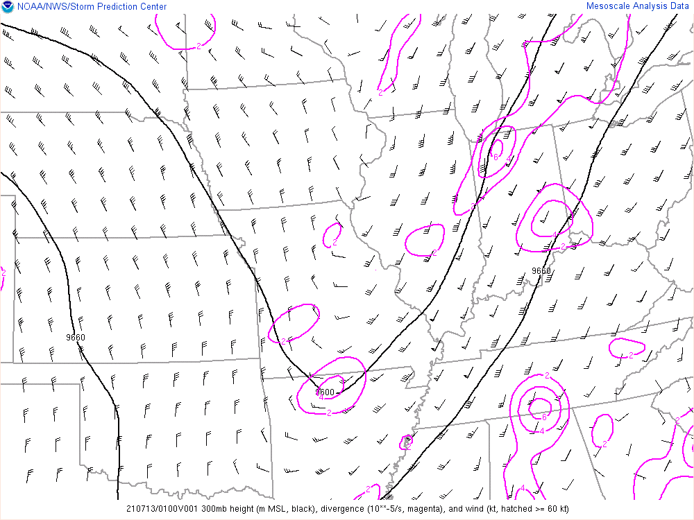
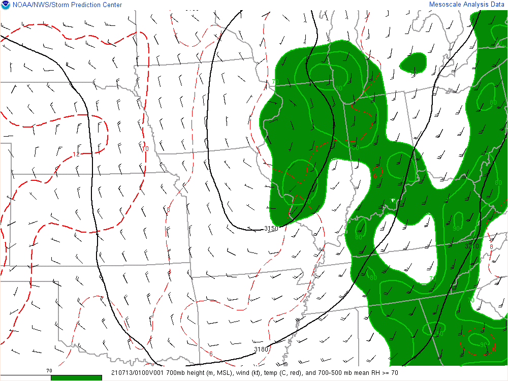
Meteorology
 |
 |
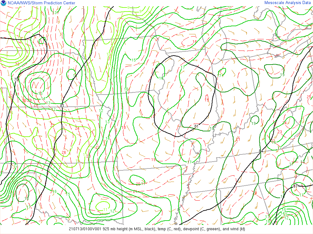 |
| 300 mb (about 30,000 feet) analysis showing a modest jet streak on the east side of a large trough axis. | 700 mb (about 10,000 feet) analysis showing high levels of mid-level moisture. | 925 mb (about 2,000 feet) analysis. |
 |
 |
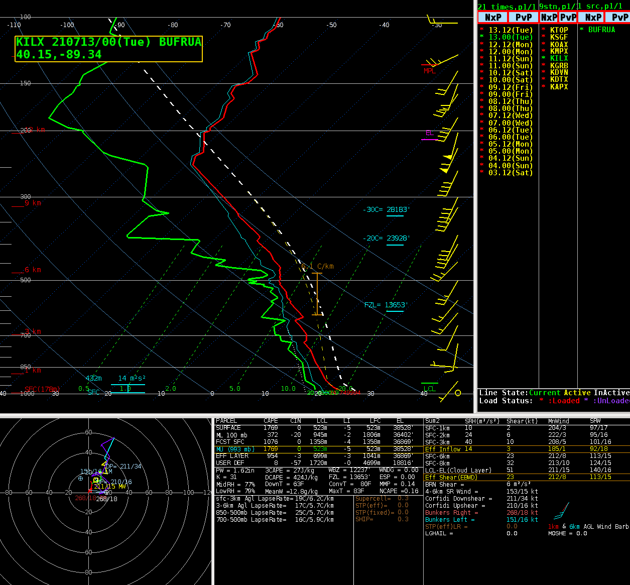 |
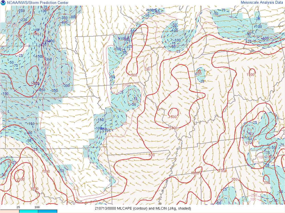
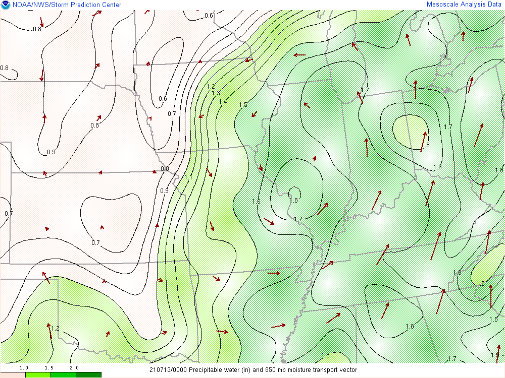
| Mixed-Layer CAPE analysis showing values near 1000 J/kg, sufficient for heavy showers and some thunderstorms. | Precipitable water (PWAT) values in excess of 1.6" suggest a very moist airmass was in place. | Central Illinois 7 PM sounding, revealing a high degree of available instability that was also uncapped (unusual for this time of day). Very slow storm motions to the north around 10 mph. |
Photos
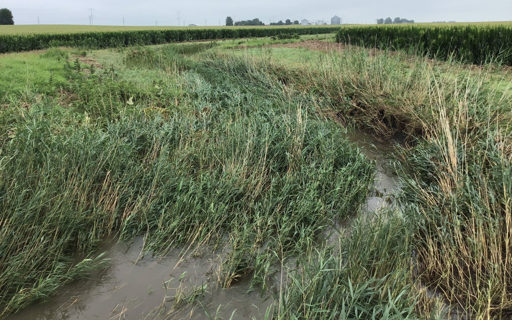
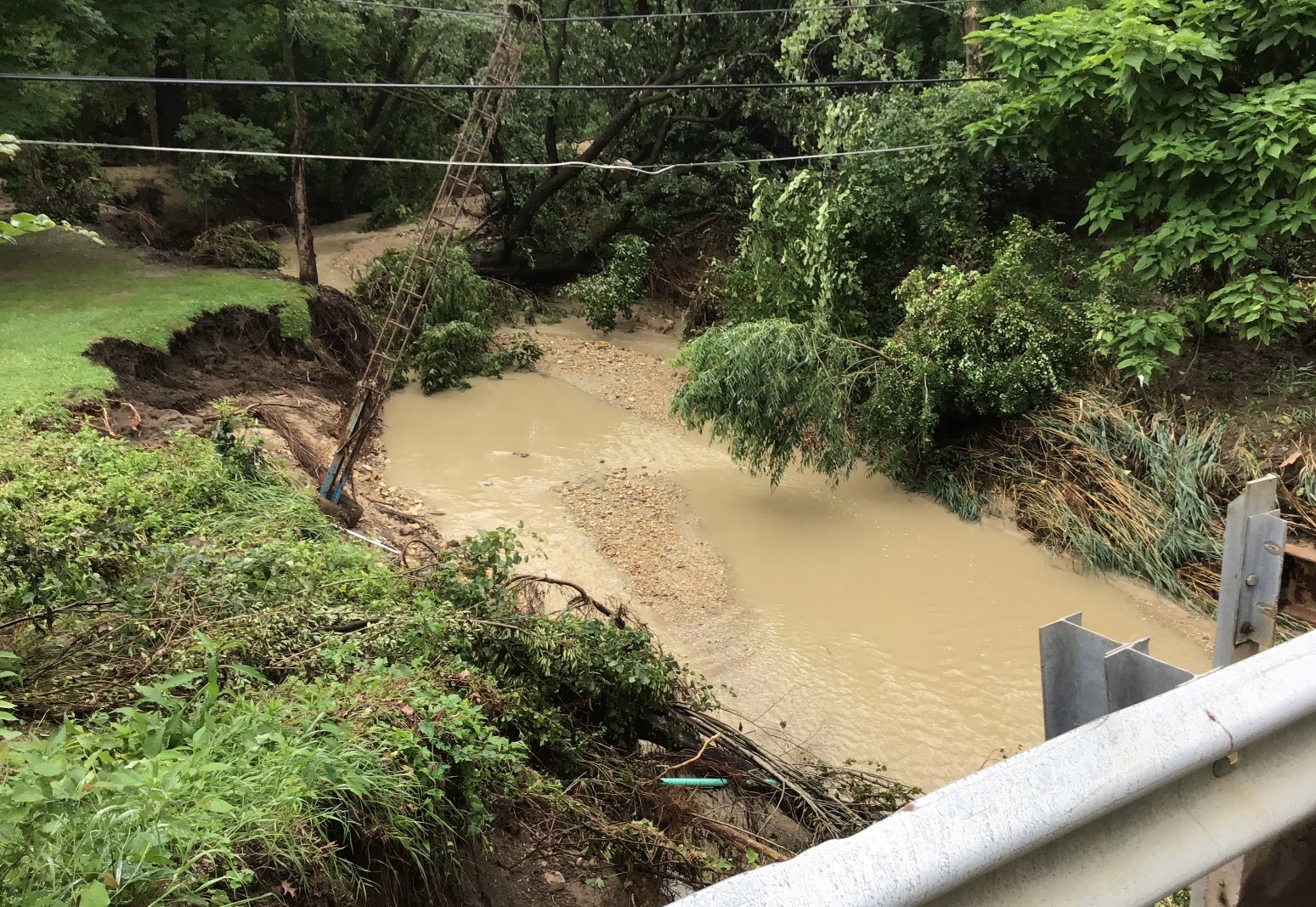
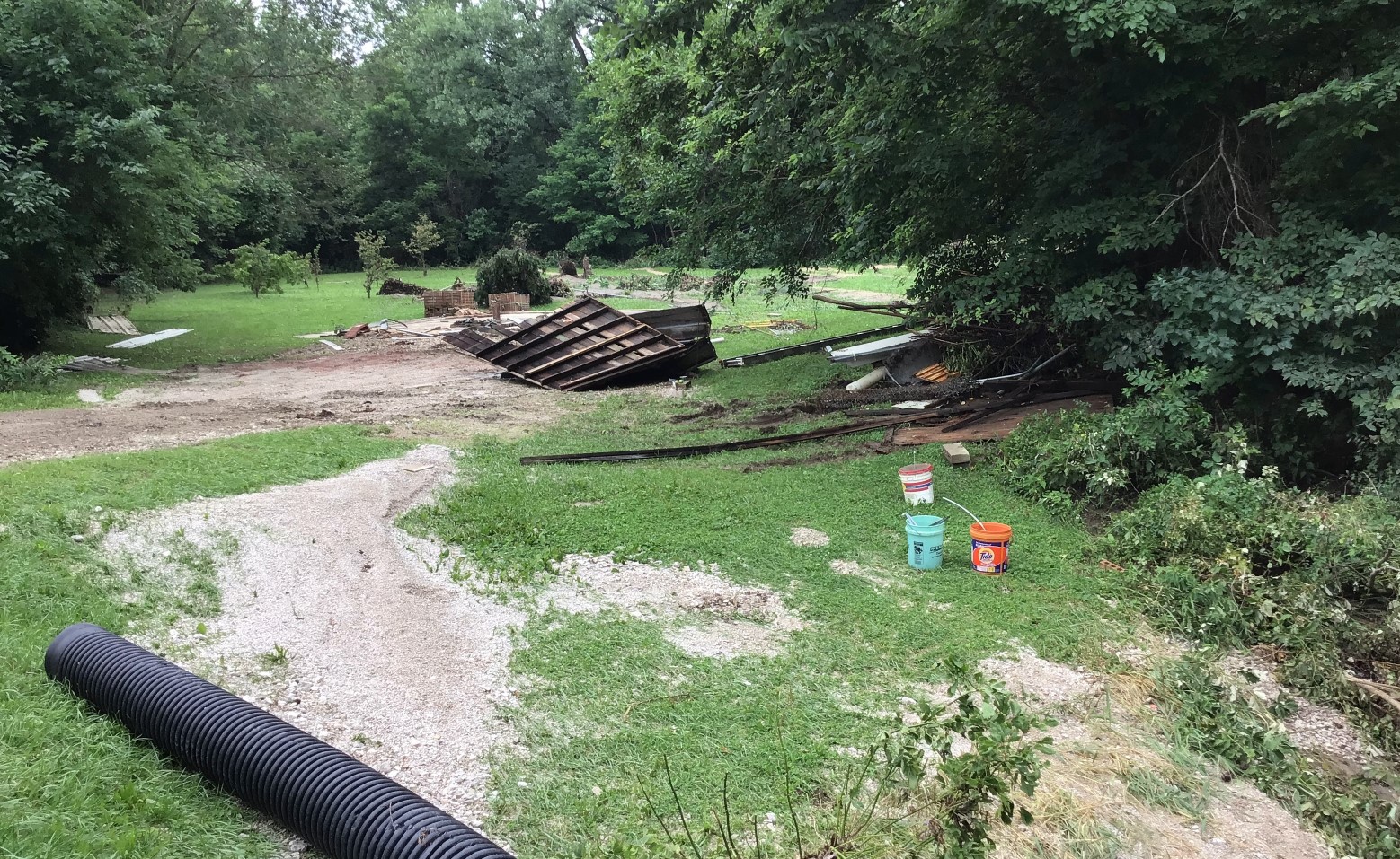
A survey of the affected areas by NWS personnel was conducted on July 16. The survey confirmed the significant flash flooding along numerous creeks south of Seneca. Some of the most notable impacts happened just downstream of steep slopes where creeks where descending into the Illinois River Valley. A few of the photos from the survey are shown below.
 |
 |
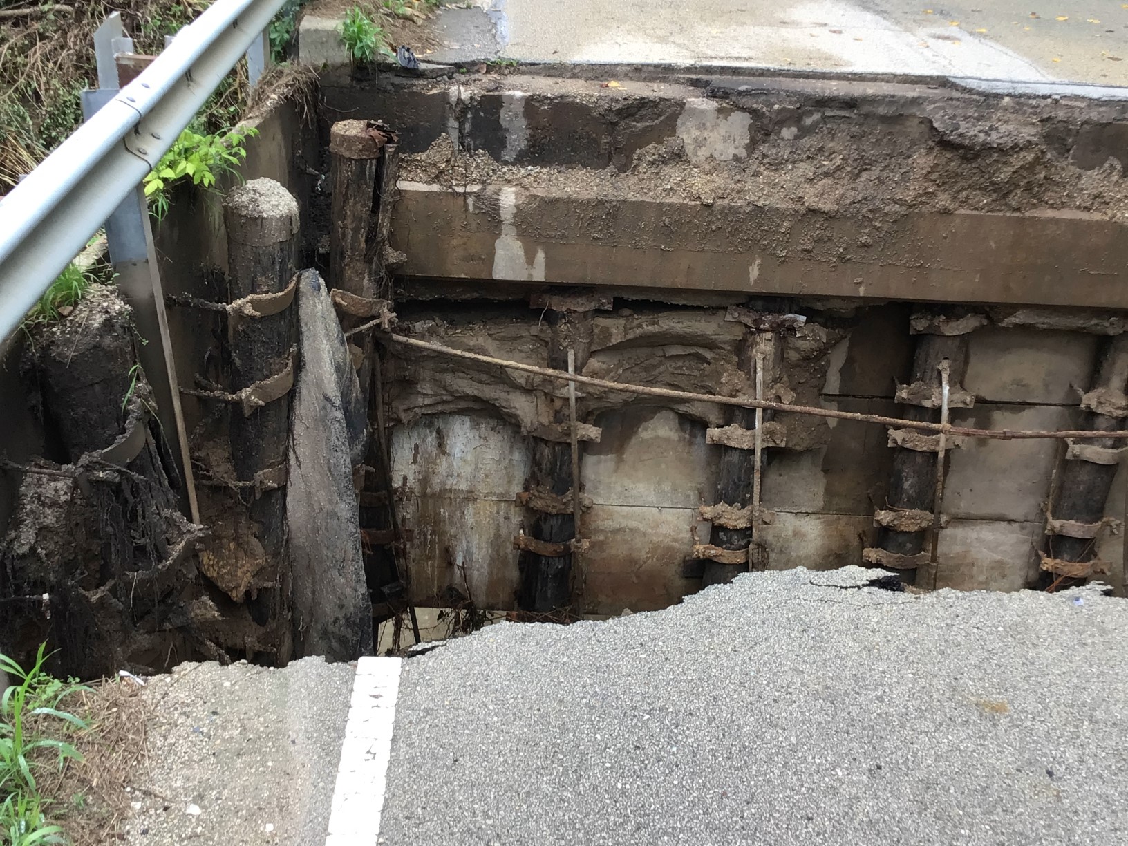 |
| Near the areas of heaviest rainfall upstream of the Illinois River Valley, flattened vegetation was common along multiple creeks. Despite the shallow slopes, water levels were high enough and moving quickly enough to cause noticeable impacts that remained for days after the event. | Near River Road west of IL-170 along an unnamed tributary of the Illinois River, flash flooding caused significant channel erosion and damage to vegetation. | At River Road west of IL-170, along an unnamed tributary of the Illinois River, flash flooding washed out the approach to a bridge, causing one injury. |
 |
 |
|
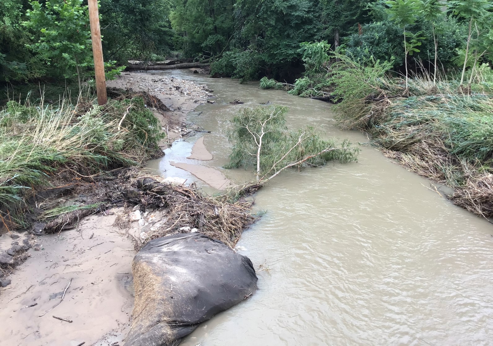
| Near Indian Trail Road along Armstrong Run, flash flooding destroyed an outbuilding and washed the debris a considerable distance downstream. The approaches to the Indian Trail Road bridge were also damaged (not pictured). | At Dupont Road along Armstrong Run, flash flooding caused significant channel erosion, flattened vegetation, and deposited large pieces of debris from upstream. The bridge over Armstrong was also damaged (not pictured). |
Additional Info
 |
Media use of NWS Web News Stories is encouraged! Please acknowledge the NWS as the source of any news information accessed from this site. Additional recaps can be found on the NWS Chicago Past Events Page |
|