
Widespread life-threatening flash and urban flooding continues in south-central Texas, with considerable flooding impacts possible across central Texas. Wildfire smoke is impacting air quality across much of the Great Lakes region into southern New England and the Mid-Atlantic. Monsoonal thunderstorms may produce isolated to scattered flash flooding across the Southwest into the Great Basin. Read More >
Overview
|
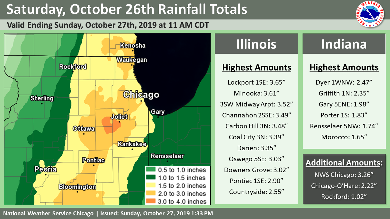
On Saturday, an expansive and strong weather system impacted the area. This system had tropical moisture within it from the remnants of Tropical Storm Olga that had made landfall on Louisiana. This system produced a 9-12 hour period of rain across much of northern Illinois and a 6-9 hour period for northwest Indiana. Rainfall rates were heavy especially late Saturday afternoon into the evening. This resulted in flooding developing over a few to several hour period, even borderline flash flooding in places. Widespread rainfall of 1.50" to 3.50" were observed. Chicago O'Hare received 2.22", and of that 2.18" fell on October 26th. That was a record for that date. It also was the 10th calendar day in 2019 with over one inch of precipitation, and the 6th such day in just the past two months (since Oct 27) with 1+" of rain. This system also brought gusty winds, with gusts to near 45 mph along the lakefront. This resulted in high waves peaking over 10 ft at the Wilmette, IL and Michigan City, IN buoys. |
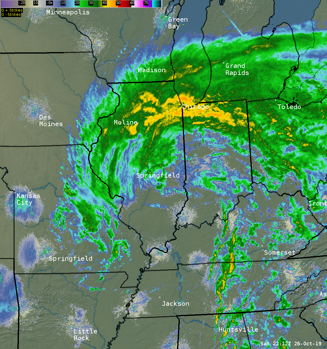 Radar snapshot from 6 pm on Oct 26. (loop) |
Flooding Reports
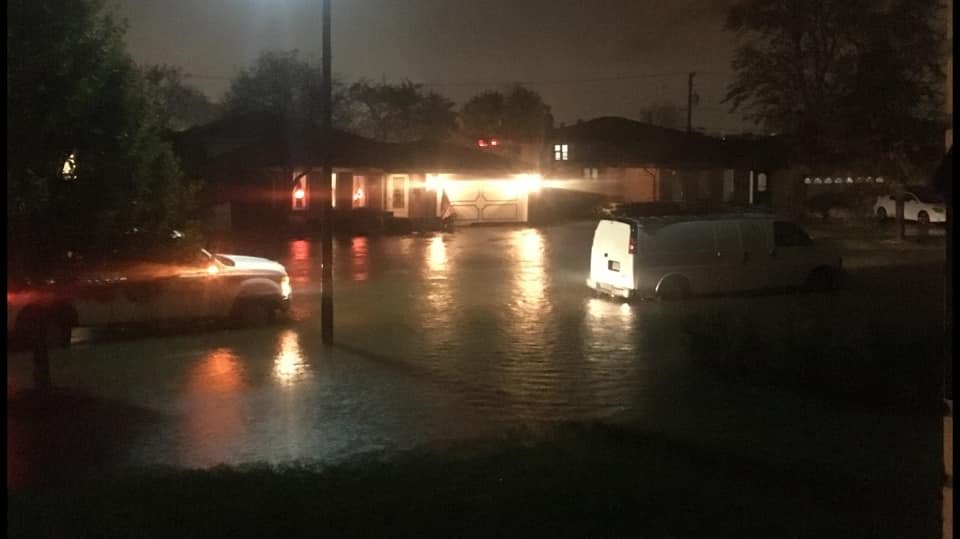 |
| Flooding in Tinley Park, IL |
PRELIMINARY LOCAL STORM REPORT...SUMMARY
NATIONAL WEATHER SERVICE CHICAGO IL
901 AM CDT SUN OCT 27 2019

..TIME...   ...EVENT...      ...CITY LOCATION...     ...LAT.LON...
..DATE...   ....MAG....      ..COUNTY LOCATION..ST.. ...SOURCE....
            ..REMARKS..

0600 PM     FLOOD            1 N ELMHURST            41.91N 87.94W
10/26/2019                   DUPAGE             IL   PUBLIC

            FLOODING OF RIGHT TWO LANES REPORTED AT
            I-290 AND YORK ROAD.

0709 PM     FLOOD            OHARE AIRPORT           41.98N 87.90W
10/26/2019                   COOK               IL   DEPT OF HIGHWAYS

            ENTRANCE TO MAIN PARKING GARAGE AT OHARE
            AIRPORT WAS CLOSED DUE TO A FLOODED ROADWAY.

0822 PM     HEAVY RAIN       1 W BRIDGEPORT          41.83N 87.67W
10/26/2019  M3.14 INCH       COOK               IL   MESONET

            MCKINLEY PARK NEIGHBORHOOD IN CHICAGO.
            RELAYED VIA BROADCAST MEDIA.

0832 PM     HEAVY RAIN       WESTCHESTER             41.85N 87.89W
10/26/2019  M2.03 INCH       COOK               IL   MESONET

            RELAYED VIA BROADCAST MEDIA.

0835 PM     FLOOD            TINLEY PARK             41.57N 87.80W
10/26/2019                   COOK               IL   BROADCAST MEDIA

            RESIDENTIAL STREET FLOODING REPORTED NEAR
            174TH STREET AND OSCEOLA AVENUE.

0841 PM     FLOOD            1 NNE WESTCHESTER       41.86N 87.88W
10/26/2019                   COOK               IL   PUBLIC

            STANDING WATER OF OVER ONE FOOT DEEP AT AN
            INTERSECTION IN WESTCHESTER, IL.

0844 PM     NON-TSTM WND GST 1 SE KENTLAND           40.76N 87.43W
10/26/2019  M54 MPH          NEWTON             IN   BROADCAST MEDIA

            54 MPH GUST AT KENTLAND MUNICIPAL AIRPORT.
            RELAYED BY WLFI.

0850 PM     NON-TSTM WND DMG 2 NW BOLINGBROOK        41.72N 88.10W
10/26/2019                   WILL               IL   PUBLIC

            LARGE TREE DOWNED ON TRILLIUM LANE IN
            NAPERVILLE, IL. WINDS WERE LIKELY UNDER 60
            MPH WHICH TYPICALLY IS NEEDED FOR SUCH
            DAMAGE AND THE WET GROUND PROBABLY PLAYED A
            KEY ROLE.

0900 PM     FLOOD            3 SW PLAINFIELD         41.58N 88.26W
10/26/2019                   WILL               IL   NWS EMPLOYEE

            TIME ESTIMATED. LOCATION WAS ON COUNTY LINE
            ROAD IN-BETWEEN RENWICK AND CATON FARM RDS.
            THERE APPEARS TO HAVE BEEN FOUR ABANDONED
            VEHICLES WITH STILL SOME STANDING WATER WHEN
            THIS WAS SEEN SUNDAY MORNING. THIS MAY HAVE
            BEEN CLOSE TO TRUE FLASH FLOODING.

0910 PM     FLOOD            1 SSE MAYWOOD           41.86N 87.83W
10/26/2019                   COOK               IL   PUBLIC

            FLOODING ON SOUTH BOUND 1ST AVENUE JUST PAST
            ROOSEVELT ROAD. REPORT OF STALLED CARS.

0919 PM     HEAVY RAIN       OAK LAWN                41.71N 87.75W
10/26/2019  M2.90 INCH       COOK               IL   COCORAHS

            STORM TOTAL 2.90 INCHES SO FAR.

0942 PM     HEAVY RAIN       STREATOR                41.13N 88.83W
10/26/2019  M4.22 INCH       LA SALLE           IL   PUBLIC

            RELAYED VIA WGN TV.

1025 PM     FLOOD            2 S BRIDGEPORT          41.81N 87.65W
10/26/2019                   COOK               IL   PUBLIC

            REPORTED AT OR NEAR 4700 S HALSTED, CHICAGO,
            IL. VEHICLE STUCK ON FLOODED ROAD.

1050 PM     HEAVY RAIN       3 SE ST. JOHN           41.42N 87.43W
10/26/2019  M2.15 INCH       LAKE               IN   TRAINED SPOTTER


0114 AM     HEAVY RAIN       3 SW MIDWAY AIRPORT     41.74N 87.78W
10/27/2019  M3.45 INCH       COOK               IL   CO-OP OBSERVER

            24 HOUR TOTAL THROUGH 1 AM CDT.
Rain Reports
 |
| Rainfall |
Public Information Statement
National Weather Service Chicago IL
1016 AM CDT Sun Oct 27 2019

...Morning Rainfall Roundup...

   The following are rain amounts for the previous 24-hours
   as measured in the morning by NWS Cooperative Observers
   and CoCoRaHS observers.
   Observations are usually taken between 6 AND 8 AM.

   24-hour rainfall amounts
       for Sunday(10/27/19)...


Illinois                                       Rain
  Location (County):                           fall (inches)

  Lockport 1SE (Will)..........................3.65
  Minooka (Grundy).............................3.61
  Midway Coop (Cook)...........................3.52
  Channahon 2SSE (Will)........................3.49
  Carbon Hill 3.1N (Grundy)....................3.48
  Brandon Road Lock & Dam (Will)...............3.40
  Coal City 3N (Grundy)........................3.39
  Darien (Du Page).............................3.35
  Countryside 1ENE (Cook)......................3.30
  Palos Park 4WNW (Cook).......................3.28
  Romeoville (Will)............................3.26
  Wilmington 6NW (Will)........................3.22
  Oak Lawn (Cook)..............................3.21
  Mazon 0.5ENE (Grundy)........................3.19
  Joliet 3WNW (Will)...........................3.19
  Plainfield 3ESE (Will).......................3.09
  Channahon 1NNE (Will)........................3.09
  Joliet 2n (Will).............................3.08
  Plainfield 2SSE (Will).......................3.04
  Dwight 4NNW (Grundy).........................3.03
  Oswego 5SSE (Kendall)........................3.03
  Downers Grove 0.4NNE (Du Page)...............3.02
  Chicago 6ESE (Cook)..........................2.93
  Pontiac 1SE (Livingston).....................2.90
  Harwood Heights (Cook).......................2.87
  New Lenox 3ENE (Will)........................2.87
  Bridgeview 1NNW (Cook).......................2.85
  La Grange Park 1SSW (Cook)...................2.85
  Downers Grove 1S (Du Page)...................2.85
  Oak Park 2S (Cook)...........................2.84
  Palos Park 1SW (Cook)........................2.83
  Bolingbrook 3NE (Du Page)....................2.83
  Willow Springs (Cook)........................2.82
  Morris (Grundy)..............................2.78
  Joliet (Will)................................2.77
  Manhattan 2SE (Will).........................2.75
  Chicago Ridge (Cook).........................2.74
  Rogers Park 2SW (Cook).......................2.74
  New Lenox 2SE (Will).........................2.74
  Wilmington 3SE (Will)........................2.73
  Elwood 5NE (Will)............................2.71
  Elmhurst 2SE (Du Page).......................2.68
  Oak Park 1NNE (Cook).........................2.67
  Peotone (Will)...............................2.67
  Oak Lawn 2SE (Cook)..........................2.66
  Lincolnwood 2E (Cook)........................2.66
  Plainfield 5SW (Kendall).....................2.65
  Lisle 1SE (Du Page)..........................2.63
  Naperville 4SSW (Will).......................2.63
  Flossmoor 1ESE (Cook)........................2.62
  Naperville 2SE (Du Page).....................2.62
  Romeoville (Will)............................2.62
  Manhattan 5ENE (Will)........................2.61
  Morris 2SSE (Grundy).........................2.60
  Lisle 1SW (Du Page)..........................2.59
  Homer Glen 1ENE (Will).......................2.59
  Emington 2SSE (Livingston)...................2.58
  Manhattan 1ESE (Will)........................2.58
  Aurora 4SE (Du Page).........................2.57
  Elmhurst (Du Page)...........................2.56
  New Lenox 3E (Will)..........................2.56
  Burr Ridge 2SW (Du Page).....................2.54
  Gibson 3WNW (Ford)...........................2.54
  Aurora 4SE (Du Page).........................2.52
  Seneca 1NNE (La Salle).......................2.51
  Crete 3E (Will)..............................2.51
  Lisle (Du Page)..............................2.50
  Naperville 1NW (Du Page).....................2.50
  Morris 5NNW (Grundy).........................2.47
  Herscher 3E (Kankakee).......................2.47
  Manhattan (Will).............................2.47
  Elmhurst 1ESE (Du Page)......................2.46
  Elk Grove Village 2WSW (Cook)................2.45
  Glen Ellyn 1WSW (Du Page)....................2.45
  Park Forest (Cook)...........................2.45
  Bourbonnais (Kankakee).......................2.44
  Highwood 1S (Lake)...........................2.44
  Pontiac (Livingston).........................2.43
  Roselle 1ESE (Du Page).......................2.40
  Ashkum 5.6E (Iroquois).......................2.40
  Buckley (Iroquois)...........................2.40
  Chicago 6NNE (Cook)..........................2.39
  Elk Grove Village 1ESE (Cook)................2.39
  Chatsworth (Livingston)......................2.35
  Homewood (Cook)..............................2.35
  Monee (Will).................................2.34
  Westmont (Du Page)...........................2.33
  Midlothian 1SE (Cook)........................2.31
  Gibson 2SW (Ford)............................2.31
  Montgomery 1SSE (Kendall)....................2.31
  Streator 1WSW (La Salle).....................2.29
  Midway (Cook)................................2.29
  Aurora (Kane)................................2.26
  Bannockburn (Lake)...........................2.26
  Wheaton 2NNE (Du Page).......................2.25
  Waukegan 2N (Lake)...........................2.23
  Arlington Heights 1SW (Cook).................2.22
  Ohare Airport (Cook).........................2.22
  Carol Stream (Du Page).......................2.21
  Park Ridge (Cook)............................2.20
  Chebanse (Kankakee)..........................2.20
  Manteno 2NW (Kankakee).......................2.20
  Ottawa 1NW (La Salle)........................2.19
  Schaumburg 2E (Cook).........................2.18
  Midlothian (Cook)............................2.18
  Lake Bluff 1W (Lake).........................2.18
  Gibson 6NE (Ford)............................2.16
  Oak Park 1SW (Cook)..........................2.14
  Winthrop Harbor 1SSW (Lake)..................2.14
  Winnetka 1ESE (Cook).........................2.11
  Ottawa 2N (La Salle).........................2.11
  Beecher 3ENE (Will)..........................2.11
  Cissna Park 1S (Iroquois)....................2.10
  Riverwoods (Lake)............................2.10
  North Aurora 2NE (Kane)......................2.09
  Kankakee (Kankakee)..........................2.08
  Marseilles Lock & Dam (La Salle).............2.08
  Arlington Heights 1SW (Cook).................2.07
  Momence (Kankakee)...........................2.05
  Waukegan (Lake)..............................2.03
  Zion (Lake)..................................2.00
  Earlville 5NNE (De Kalb).....................1.99
  Sugar Grove 1NE (Kane).......................1.99
  Geneva 1SSW (Kane)...........................1.98
  Wheeling (Cook)..............................1.98
  St. Charles (Kane)...........................1.97
  Schaumburg (Du Page).........................1.96
  Buffalo Grove 2N (Lake)......................1.96
  Beecher 3SSE (Will)..........................1.96
  Batavia 2WNW (Kane)..........................1.95
  Batavia 1WNW (Kane)..........................1.94
  Aurora (Kane)................................1.93
  Watseka 6.9WNW (Iroquois)....................1.93
  Batavia (Kane)...............................1.92
  Lombard 1NNW (Du Page).......................1.92
  Somonauk 2NE (De Kalb).......................1.91
  Lincolnshire 1N (Lake).......................1.90
  Sugar Grove 1ENE (Kane)......................1.88
  Lansing (Cook)...............................1.85
  Palatine 1E (Cook)...........................1.83
  Streamwood 1W (Cook).........................1.83
  Lake Villa 2WSW (Lake).......................1.83
  La Salle (La Salle)..........................1.82
  Hoffman Estates 5W (Cook)....................1.81
  Elgin 8WSW (Kane)............................1.81
  Paw Paw (Lee)................................1.81
  North Utica 6N (La Salle)....................1.80
  Mundelein (Lake).............................1.79
  De Kalb (De Kalb)............................1.77
  Gurnee 2W (Lake).............................1.77
  Elburn (Kane)................................1.76
  Mundelein (Lake).............................1.76
  Lake Zurich (Lake)...........................1.76
  Park Forest 1NNE (Cook)......................1.75
  Lake Zurich 1N (Lake)........................1.74
  West Chicago (Du Page).......................1.71
  Earlville 3S (La Salle)......................1.71
  McHenry (Stratton Lock & Dam) (McHenry)......1.70
  Algonquin 1N (McHenry).......................1.69
  De Kalb 1SW (De Kalb)........................1.67
  Barrington (Lake)............................1.65
  Capron (Boone)...............................1.63
  Fox Lake 2SE (Lake)..........................1.61
  Peru 1ENE (La Salle).........................1.61
  Dekalb (De Kalb).............................1.60
  Bull Valley 2WNW (McHenry)...................1.60
  Crystal Lake (McHenry).......................1.58
  De Kalb (De Kalb)............................1.58
  Wonder Lake 1WNW (McHenry)...................1.57
  Elgin (Kane).................................1.56
  Palatine 1NNE (Cook).........................1.56
  Plano (Kendall)..............................1.55
  Elgin (Kane).................................1.54
  Elgin 1S (Kane)..............................1.54
  Woodstock 4SW (McHenry)......................1.52
  Genoa (De Kalb)..............................1.51
  Elgin 2WNW (Kane)............................1.51
  Chicago 5NE (Cook)...........................1.49
  Mendota (La Salle)...........................1.45
  Crystal Lake 1WSW (McHenry)..................1.45
  Mendota (La Salle)...........................1.42
  Woodstock 5nw (McHenry)......................1.42
  Kingston 2WNW (De Kalb)......................1.40
  Flossmoor (Cook).............................1.39
  Elgin 2W (Kane)..............................1.37
  Steward (Lee)................................1.32
  Rockford 3NE (Winnebago).....................1.30
  Rockford 2ENE (Winnebago)....................1.26
  Ashton (Lee).................................1.08
  Peru (La Salle)..............................1.03
  Rockford (Winnebago).........................1.02
  Rockford 1NW (Winnebago).....................1.00
  Dixon 3NNW (Lee).............................0.82
  Rochelle (Ogle)..............................0.72

Indiana                                        Rain
  Location (County):                           fall (inches)

  Dyer 1WNW (Lake).............................2.47
  Griffith 1N (Lake)...........................2.35
  Schererville 1E (Lake).......................2.33
  Gary 5ENE (Lake).............................1.98
  Hobart 1SSW (Lake)...........................1.85
  Porter 1S (Porter)...........................1.83
  Rensselaer 5NW (Jasper)......................1.78
  Kentland (Newton)............................1.78
  Rensselaer 4N (Jasper).......................1.74
  Wheatfield 4WSW (Jasper).....................1.73
  De Motte 4SW (Jasper)........................1.71
  De Motte 6S (Jasper).........................1.70
  De Motte 1SSW (Jasper).......................1.70
  Mount Ayr 2NNE (Newton)......................1.68
  Winfield 1NE (Lake)..........................1.66
  Valparaiso 6NW (Porter)......................1.66
  Valparaiso 1NNW (Porter).....................1.66
  Morocco (Newton).............................1.65
  De Motte 1NNW (Jasper).......................1.63
  Valparaiso 4SW (Porter)......................1.58
  Rensselaer (Jasper)..........................1.56
  Rensselaer 10NNE (Jasper)....................1.55
  Valparaiso 2WNW (Porter).....................1.55
  Valparaiso 6SSW (Porter).....................1.53
  Rensselaer 2SSW (Jasper).....................1.50
  Kentland 2SSE (Newton).......................1.50
  Valparaiso 2NW (Porter)......................1.48
  Valparaiso 1SE (Porter)......................1.46
  Valparaiso (Porter)..........................1.46
  Hebron 1NW (Porter)..........................1.43
  Remington (Jasper)...........................1.37
  Crown Point (Lake)...........................1.13
  Crown Point 1N (Lake)........................1.13

$$

Petr
Meteorology
 |
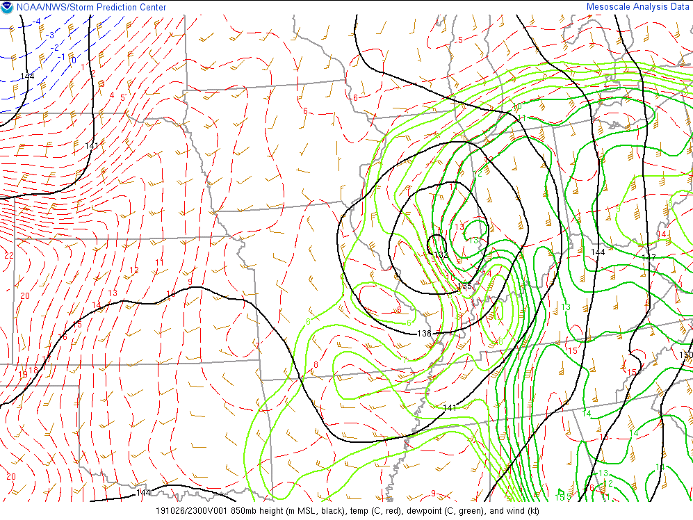 |
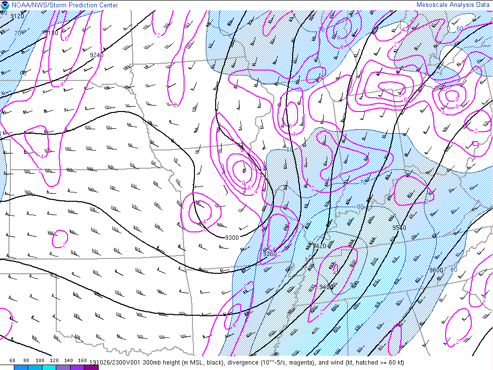
| This is a look at 300 mb at 6 pm on Oct 26. Notice the tilt of the upper trough to the southeast, which at our latitude we consider a negative tilt. This is often ideal for active weather and one reason for this is the upper jet is situated for deep ascent directly ahead of the system. In this case, the upper jet was even "coupled" over our area (basically between the two blue areas on this map). This deep ascent helped widespread rain development as well as the system deepening as a whole, leading to moisture influx and focus for heavier rain. | This is a look at 850 mb at 6 pm on Oct 26. Highly anomalous moisture for late October was being steered into this system on strong south to southeast winds. Combined with the deep ascent noted in the left hand graphic, there was plenty of moisture replenishment and lift to sustain the heavy rain area for numerous hours. The moisture was actually directly from the Gulf, having a tropical component thanks to the remnants of Tropical Storm Olga being ingested into the larger weather system. |
 |
Media use of NWS Web News Stories is encouraged! Please acknowledge the NWS as the source of any news information accessed from this site. Additional recaps can be found on the NWS Chicago Past Events Page |
|

