Dangerous heat will expand from the Gulf Coast into the Southern Plains and Desert Southwest through week's end. Additional extreme heat impacting the Pacific Northwest will shift to the northern Plains by the weekend. Tropical Storm Bertha is expected to continue to impact portions of the northwestern Gulf Coast from south central Louisiana to the upper Texas coast today. Read More >
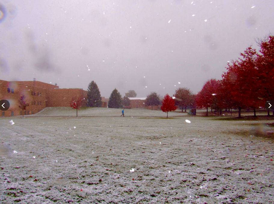
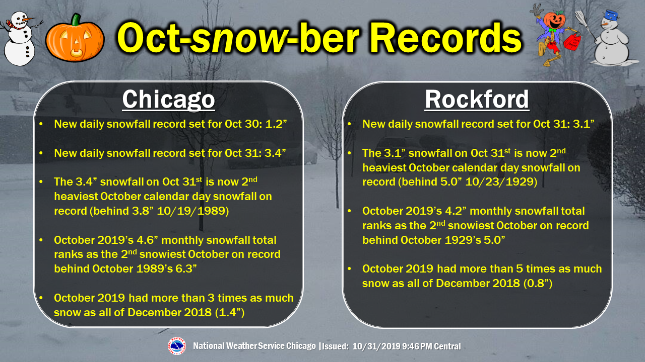
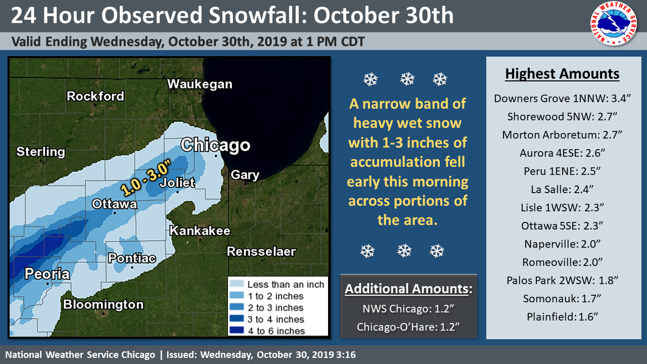
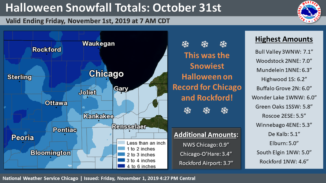
| Multiple weather systems passed across northern Illinois from Oct 29-31. The rapid succession of these resulted in cold enough air to keep precipitation type mainly as snow for the final system especially on Halloween day. The snow amounts were the most snow on Halloween day on record for long term climate sites in northern Illinois (Chicago and Rockford). Amounts were even in excess of 5" in parts of far northern Illinois. Snow had been mentioned in the forecast as early as six days in advance, and then the message of accumulating snow refined during the week of. |
|
Fast Facts
 |
| October Snow Facts |
Snow Totals
 |
 |
||
| Oct 29-30 Snowfall Event: List | Oct 30-31 Snowfall Event: List |
Public Information Statement
National Weather Service Chicago IL
1115 AM CDT Thu Oct 31 2019

...Morning Snowfall Roundup...

   The following are snow amounts since the evening of October
   30 as measured in the morning by NWS Cooperative Observers
   and CoCoRaHS observers.
   Observations are usually taken at 7 AM. These totals do not
   include additional snowfall since 7 AM.

Northern Illinois                              Snow
  Location (County):                           fall(inches)

  Rockford 2ENE (Winnebago).....................3.0
  Woodstock 4SW (McHenry).......................2.5
  De Kalb 1SW (De Kalb).........................2.3
  De Kalb (De Kalb).............................2.1
  Roscoe 2ESE (Winnebago).......................2.1
  Roscoe 2se (Winnebago)........................2.1
  Harvard (McHenry).............................2.0
  Mendota (La Salle)............................2.0
  Bull Valley 2WNW (McHenry)....................1.9
  Rockford 1NW (Winnebago)......................1.8
  Belvidere (Boone).............................1.7
  Rockford (Winnebago)..........................1.7
  Woodstock 5nw (McHenry).......................1.6
  Hebron (McHenry)..............................1.5
  Hoffman Estates 5W (Cook).....................1.5
  Geneva 1SSW (Kane)............................1.5
  La Salle (La Salle)...........................1.5
  Rockford 3NE (Winnebago)......................1.5
  Crystal Lake (McHenry)........................1.4
  De Kalb (De Kalb).............................1.4
  Elgin (Kane)..................................1.4
  Wonder Lake 1WNW (McHenry)....................1.4
  Capron (Boone)................................1.3
  Crystal Lake 1WSW (McHenry)...................1.3
  Genoa (De Kalb)...............................1.2
  Earlville 5NNE (De Kalb)......................1.2
  Cortland (De Kalb)............................1.1
  Elgin 2W (Kane)...............................1.1
  Schaumburg 2E (Cook)..........................1.0
  Aurora 4SE (Du Page)..........................1.0
  Lake Villa 1SSW (Lake)........................1.0
  Lake Villa 2WSW (Lake)........................1.0
  Ottawa 2N (La Salle)..........................1.0
  Algonquin 1N (McHenry)........................1.0
  Mendota (La Salle)............................1.0
  Paw Paw (Lee).................................1.0
  Downers Grove 0.4NNE (Du Page)................0.9
  Sugar Grove 1NE (Kane)........................0.9
  Barrington (Lake).............................0.8
  Batavia (Kane)................................0.8
  Naperville 1NW (Du Page)......................0.8
  Gurnee 2W (Lake)..............................0.8
  Streator 1WSW (La Salle)......................0.8
  Mundelein (Lake)..............................0.8
  Earlville 3S (La Salle).......................0.7
  Batavia 1WNW (Kane)...........................0.7
  St. Charles 6NW (Kane)........................0.7
  Lake Zurich (Lake)............................0.7
  Hoffman Estates 2SE (Cook)....................0.6
  Roselle 1ESE (Du Page)........................0.6
  Batavia 2WNW (Kane)...........................0.6
  North Aurora 2NE (Kane).......................0.6
  Elgin (Kane)..................................0.5
  Mount Prospect 3NE (Cook).....................0.5
  Aurora 4SE (Du Page)..........................0.5
  Elmhurst 1ESE (Du Page).......................0.5
  Wheaton 2NNE (Du Page)........................0.5
  Oswego 5SSE (Kendall).........................0.5
  Plainfield 5SW (Kendall)......................0.5
  Buffalo Grove 2N (Lake).......................0.5
  Ohare Airport (Cook)..........................0.5
  Rochelle (Ogle)...............................0.5
  Oak Park 1NNE (Cook)..........................0.4
  Coal City (Grundy)............................0.4
  Morris 6ESE (Grundy)..........................0.4
  Highwood 1S (Lake)............................0.4
  Midway Coop (Cook)............................0.4
  Morris (Grundy)...............................0.4
  Steward (Lee).................................0.4
  Coal City 4NNW (Grundy).......................0.3
  Palatine 1E (Cook)............................0.3
  Park Ridge (Cook).............................0.3
  Elk Grove Village 2WSW (Cook).................0.3
  Carbon Hill 3.1N (Grundy).....................0.3
  Montgomery 1SSE (Kendall).....................0.3
  Naperville 4SSW (Will)........................0.3
  Lisle Morton Arb (Du Page)....................0.3
  Park Ridge 1WNW (Cook)........................0.2
  Bolingbrook 3NE (Du Page).....................0.2
  Darien (Du Page)..............................0.2
  Burr Ridge 2SW (Du Page)......................0.2
  Dwight 4NNW (Grundy)..........................0.2
  Manhattan 5ENE (Will).........................0.2
  Joliet 2n (Will)..............................0.2
  Romeoville (Will).............................0.2
  Manhattan (Will)..............................0.2
  Oak Park 2S (Cook)............................0.1
  Harwood Heights (Cook)........................0.1
  Palatine 1NNE (Cook)..........................0.1
  La Grange Park 1SSW (Cook)....................0.1
  Minooka (Grundy)..............................0.1
  Plainfield 2SSE (Will)........................0.1
  Plainfield (Will).............................0.1
  Streator (Livingston).........................0.1
  Round Lake 2WNW (Lake)........................0.1
  Dwight (Livingston).........................TRACE
  Elburn (Kane)...............................TRACE
  Bridgeview 1NNW (Cook)......................TRACE
  Oak Lawn (Cook).............................TRACE
  Chicago Ridge (Cook)........................TRACE
  Rogers Park 2SW (Cook)......................TRACE
  Palos Park 1SW (Cook).......................TRACE
  Homewood (Cook).............................TRACE
  Lincolnwood 2E (Cook).......................TRACE
  Lisle (Du Page).............................TRACE
  Elburn (Kane)...............................TRACE
  Lincolnshire 1N (Lake)......................TRACE
  Riverwoods (Lake)...........................TRACE
  Homer Glen 1ENE (Will)......................TRACE
  Peotone (Will)..............................TRACE
  New Lenox 2SE (Will)........................TRACE
  Lockport 1SE (Will).........................TRACE
  New Lenox 3E (Will).........................TRACE
  Brandon Road Lock & Dam (Will)..............TRACE
  Monee (Will)................................TRACE
  Peotone (Will)..............................TRACE

Northwest Indiana                              Snow
  Location (County):                           fall(inches)

  ................................ NO SNOW REPORTED
Public Information Statement
National Weather Service Chicago IL
0300 AM CDT Sat Nov 02 2019

...October 31 Snowfall Summary...

The following are snow amounts taken on November 1 near 7 am for the
prior 24 hours. These are taken by NWS Cooperative Observers and
CoCoRaHS observers.

Observations are usually taken at 7 AM.

Northern Illinois                              Snow
  Location (County):                           fall(inches)

  Highwood 1S (Lake)............................5.8
  Buffalo Grove 2N (Lake).......................5.5
  Mundelein (Lake)..............................5.5
  Bull Valley 2WNW (McHenry)....................5.2
  Elburn (Kane).................................5.0
  Lake Zurich (Lake)............................4.7
  Wonder Lake 1WNW (McHenry)....................4.6
  Genoa (De Kalb)...............................4.5
  Elgin 2W (Kane)...............................4.5
  Paw Paw (Lee).................................4.5
  Cortland (De Kalb)............................4.3
  Cary (McHenry)................................4.3
  Woodstock 4SW (McHenry).......................4.2
  Hoffman Estates 2SE (Cook)....................4.1
  Steward (Lee).................................4.1
  Elmhurst 1ESE (Du Page).......................4.0
  St. Charles 6NW (Kane)........................4.0
  Lake Villa 1SSW (Lake)........................4.0
  Algonquin 1N (McHenry)........................4.0
  Park Ridge 1WNW (Cook)........................3.9
  Batavia (Kane)................................3.8
  Arlington Heights 1SW (Cook)..................3.8
  Batavia 1WNW (Kane)...........................3.8
  Riverwoods (Lake).............................3.8
  Park Ridge (Cook).............................3.6
  Elgin (Kane)..................................3.5
  Schaumburg 2E (Cook)..........................3.5
  Lincolnwood 2E (Cook).........................3.5
  Geneva 1SSW (Kane)............................3.5
  Crystal Lake 1WSW (McHenry)...................3.5
  Roscoe 2ESE (Winnebago).......................3.4
  Roscoe 2se (Winnebago)........................3.4
  Ohare Airport (Cook)..........................3.2
  Woodstock 5nw (McHenry).......................3.2
  De Kalb (De Kalb).............................3.0
  Palatine 1NNE (Cook)..........................3.0
  Elk Grove Village 1ESE (Cook).................3.0
  Elk Grove Village 2WSW (Cook).................3.0
  Aurora 4SE (Du Page)..........................3.0
  Morris 6ESE (Grundy)..........................3.0
  Elgin 1S (Kane)...............................3.0
  Geneva 4WSW (Kane)............................3.0
  Lincolnshire 1N (Lake)........................3.0
  Lake Villa 2WSW (Lake)........................3.0
  Lockport 1SE (Will)...........................3.0
  Marseilles Lock & Dam (La Salle)..............3.0
  Ottawa (La Salle).............................3.0
  Oak Park 1NNE (Cook)..........................2.9
  Lincolnwood 3E (Cook).........................2.8
  Rockford 1NW (Winnebago)......................2.8
  Plainfield (Will).............................2.8
  Roselle 1ESE (Du Page)........................2.6
  Ottawa 2N (La Salle)..........................2.6
  Mundelein (Lake)..............................2.6
  Chatsworth (Livingston).......................2.5
  Elgin (Kane)..................................2.5
  Bridgeview 1NNW (Cook)........................2.5
  Oak Lawn (Cook)...............................2.5
  De Kalb (De Kalb).............................2.5
  Wheaton 2NNE (Du Page)........................2.5
  Carol Stream (Du Page)........................2.5
  Naperville 2SE (Du Page)......................2.5
  New Lenox 2SE (Will)..........................2.5
  New Lenox 3E (Will)...........................2.5
  Rockford 3NE (Winnebago)......................2.5
  Westmont (Du Page)............................2.5
  Lisle 1SE (Du Page)...........................2.4
  Sugar Grove 1NE (Kane)........................2.4
  Hebron (McHenry)..............................2.3
  La Salle (La Salle)...........................2.3
  Winnetka 1ESE (Cook)..........................2.2
  Minooka (Grundy)..............................2.2
  Naperville 4SSW (Will)........................2.2
  Coal City 4NNW (Grundy).......................2.1
  Naperville 1NW (Du Page)......................2.1
  Carbon Hill 3.1N (Grundy).....................2.1
  Peotone (Will)................................2.1
  Plainfield 2SSE (Will)........................2.1
  Peotone (Will)................................2.1
  Aurora (Kane).................................2.0
  Barrington (Lake).............................2.0
  Dwight (Livingston)...........................2.0
  Dixon (Lee)...................................2.0
  Fairbury (Livingston).........................2.0
  Oak Park 2S (Cook)............................2.0
  Chicago Ridge (Cook)..........................2.0
  Oak Lawn 2WNW (Cook)..........................2.0
  North Aurora 2NE (Kane).......................2.0
  Rockford (Winnebago)..........................2.0
  Streator 1WSW (La Salle)......................1.9
  Manhattan 5ENE (Will).........................1.9
  Manhattan (Will)..............................1.9
  Midway Coop (Cook)............................1.9
  Joliet 2n (Will)..............................1.8
  Homewood (Cook)...............................1.7
  Monee (Will)..................................1.7
  Hoffman Estates 5W (Cook).....................1.5
  Aurora 4SE (Du Page)..........................1.5
  Bolingbrook 3NE (Du Page).....................1.5
  Elmhurst (Du Page)............................1.5
  Rochelle (Ogle)...............................1.5
  Capron (Boone)................................1.4
  Coal City (Grundy)............................1.3
  Montgomery 1SSE (Kendall).....................1.3
  Earlville 3S (La Salle).......................1.2
  Homer Glen 1ENE (Will)........................1.2
  Palatine 1E (Cook)............................1.1
  Harwood Heights (Cook)........................1.1
  Herscher 3E (Kankakee)........................1.1
  Belvidere (Boone).............................1.0
  La Grange Park 1SSW (Cook)....................1.0
  Burr Ridge 2SW (Du Page)......................1.0
  Watseka 6.9WNW (Iroquois).....................1.0
  Crete 3E (Will)...............................1.0
  Lansing (Cook)................................1.0
  Morris (Grundy)...............................1.0
  Park Forest (Cook)............................1.0
  St Anne (Kankakee)............................1.0
  Watseka (Iroquois)............................1.0
  Willow Springs (Cook).........................0.9
  Bourbonnais (Kankakee)........................0.8
  Lisle Morton Arb (Du Page)....................0.8
  Romeoville (Will).............................0.7
  Mendota (La Salle)............................0.6
  Palos Park 1SW (Cook).........................0.5
  Dixon 3NNW (Lee)..............................0.2
  McHenry (Stratton Lock & Dam) (McHenry).......0.1
  Ashkum 5.6E (Iroquois)......................TRACE
  Brandon Road Lock & Dam (Will)..............TRACE

Northwest Indiana                              Snow
  Location (County):                           fall(inches)

  Valparaiso 4SW (Porter).......................2.2
  Valparaiso 6SSW (Porter)......................2.0
  Hebron 4NE (Porter)...........................1.7
  Morocco (Newton)..............................1.0
  De Motte 6S (Jasper)..........................0.8
  Remington (Jasper)............................0.8
  De Motte 4SW (Jasper).........................0.8
  Valparaiso 2NW (Porter).......................0.8
  Crown Point (Lake)............................0.5
  Wheatfield 3S (Jasper)........................0.5
  Crown Point 1N (Lake).........................0.5
  Rensselaer (Jasper)...........................0.5
  Hobart 1SSW (Lake)............................0.4
  Mount Ayr 2NNE (Newton).......................0.4
  Chesterton 4E (Porter)........................0.2
  Gary 5ENE (Lake)............................TRACE
  Porter 1S (Porter)..........................TRACE
Additional Reports
PRELIMINARY LOCAL STORM REPORT...SUMMARY
NATIONAL WEATHER SERVICE CHICAGO IL
654 AM CDT FRI NOV 1 2019

..TIME...   ...EVENT...      ...CITY LOCATION...     ...LAT.LON...
..DATE...   ....MAG....      ..COUNTY LOCATION..ST.. ...SOURCE....
            ..REMARKS..

0300 PM     SNOW             2.5 W ELGIN             42.05N 88.34W
10/31/2019  M3.8 INCH        KANE               IL   COCORAHS


0300 PM     SNOW             ELK GROVE 2.2 WSW       42.00N 88.05W
10/31/2019  M3.5 INCH        COOK               IL   COCORAHS


0328 PM     SNOW             1 NW SOUTH ELGIN        42.00N 88.31W
10/31/2019  M5.0 INCH        KANE               IL   PUBLIC


0330 PM     SNOW             1.5 N BUFFALO GROVE     42.19N 87.96W
10/31/2019  M5.5 INCH        LAKE               IL   COCORAHS


0345 PM     SNOW             0.3 SSE CAROL STREAM    41.92N 88.13W
10/31/2019  M2.5 INCH        DUPAGE             IL   PUBLIC

            SNOWFALL FOR PAST 8 HOURS. TWO DAY TOTAL 3.8
            INCHES.

0400 PM     SNOW             1 SSW MEDINAH           41.97N 88.07W
10/31/2019  M5.1 INCH        DUPAGE             IL   COCORAHS

            SNOW HAS TAPERED TO JUST FLURRIES AS OF 4
            PM.

0402 PM     SNOW             3 SW MIDWAY AIRPORT     41.74N 87.78W
10/31/2019  M1.9 INCH        COOK               IL   CO-OP OBSERVER

            TOTAL SNOWFALL THROUGH 4 PM.

0409 PM     SNOW             2 SW DAYTON             41.37N 88.82W
10/31/2019  M4.0 INCH        LA SALLE           IL   PUBLIC


0457 PM     SNOW             CEDAR LAKE              41.37N 87.44W
10/31/2019  M2.1 INCH        LAKE               IN   PUBLIC

            .

0500 PM     SNOW             1 SSW GREEN OAKS        42.29N 87.92W
10/31/2019  M5.8 INCH        LAKE               IL   PUBLIC

            .

0500 PM     SNOW             2 N OTTAWA              41.37N 88.84W
10/31/2019  M2.6 INCH        LA SALLE           IL   COCORAHS

            .

0600 PM     HEAVY SNOW       2 WNW BULL VALLEY       42.32N 88.39W
10/31/2019  M7.1 INCH        MCHENRY            IL   COCORAHS

            CORRECTS PREVIOUS SNOW REPORT FROM 2 WNW
            BULL VALLEY.

0600 PM     HEAVY SNOW       2 NNE WOODSTOCK         42.35N 88.44W
10/31/2019  M7.0 INCH        MCHENRY            IL   PUBLIC

            CORRECTS PREVIOUS SNOW REPORT FROM 2 NNE
            WOODSTOCK.

0600 PM     SNOW             1 W NAPERVILLE          41.77N 88.17W
10/31/2019  M2.9 INCH        DUPAGE             IL   COCORAHS


0700 PM     SNOW             ROCKFORD AIRPORT        42.20N 89.10W
10/31/2019  M3.7 INCH        WINNEBAGO          IL   OFFICIAL NWS OBS

            STORM TOTAL.

0700 PM     SNOW             ROMEOVILLE              41.60N 88.08W
10/31/2019  M0.9 INCH        WILL               IL   OFFICIAL NWS OBS

            STORM TOTAL.

0700 PM     SNOW             OHARE AIRPORT           41.99N 87.93W
10/31/2019  M3.4 INCH        DUPAGE             IL   OFFICIAL NWS OBS

            STORM TOTAL.

0722 PM     SNOW             ROGERS PARK             42.01N 87.67W
10/31/2019  M2.1 INCH        COOK               IL   TRAINED SPOTTER

            STORM TOTAL 2.1 INCHES.

0850 PM     SNOW             2 SW DES PLAINES        42.01N 87.90W
10/31/2019  M5.0 INCH        COOK               IL   PUBLIC


0851 PM     SNOW             1 E ROLLING MEADOWS     42.08N 88.01W
10/31/2019  M5.4 INCH        COOK               IL   PUBLIC


0915 PM     SNOW             3 SSE ST. JOHN          41.42N 87.44W
10/31/2019  M2.0 INCH        LAKE               IN   COCORAHS
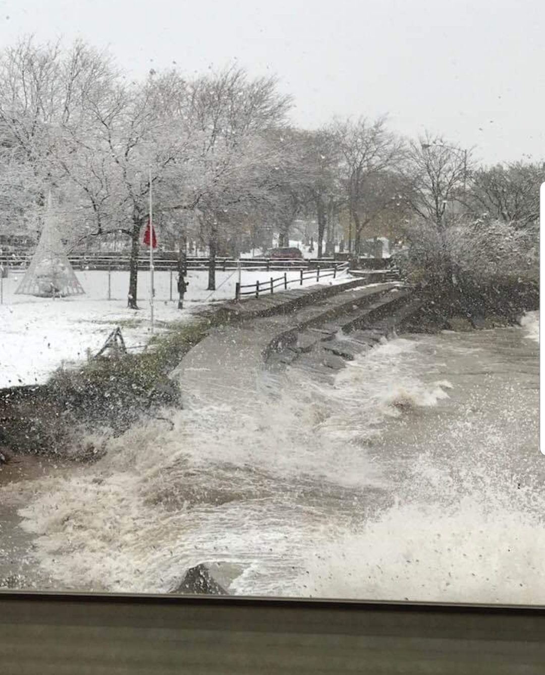
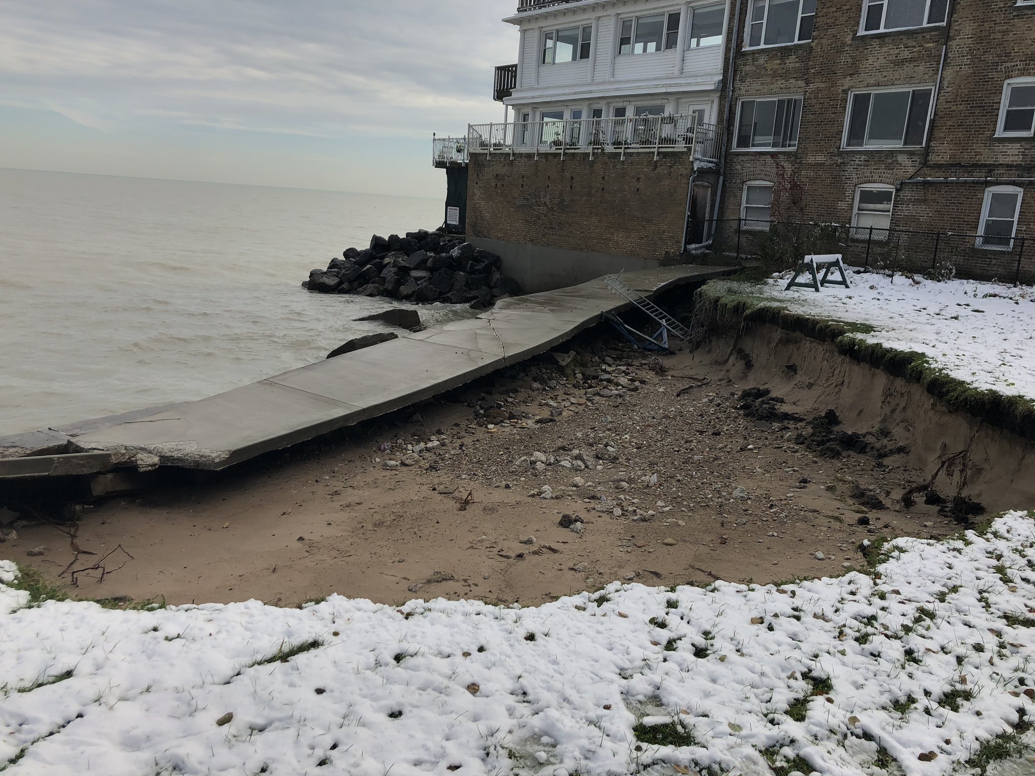
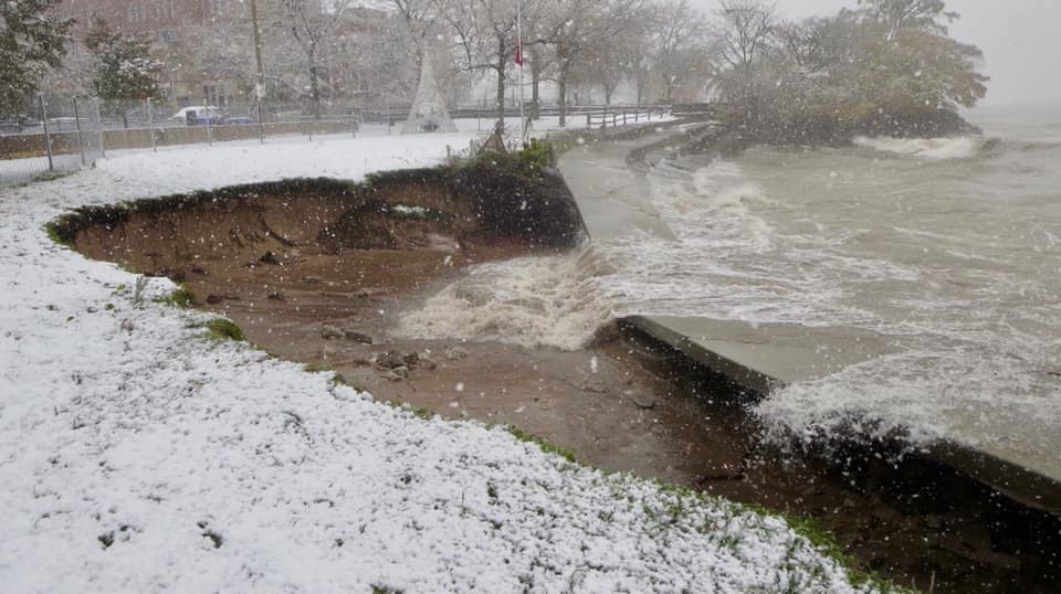
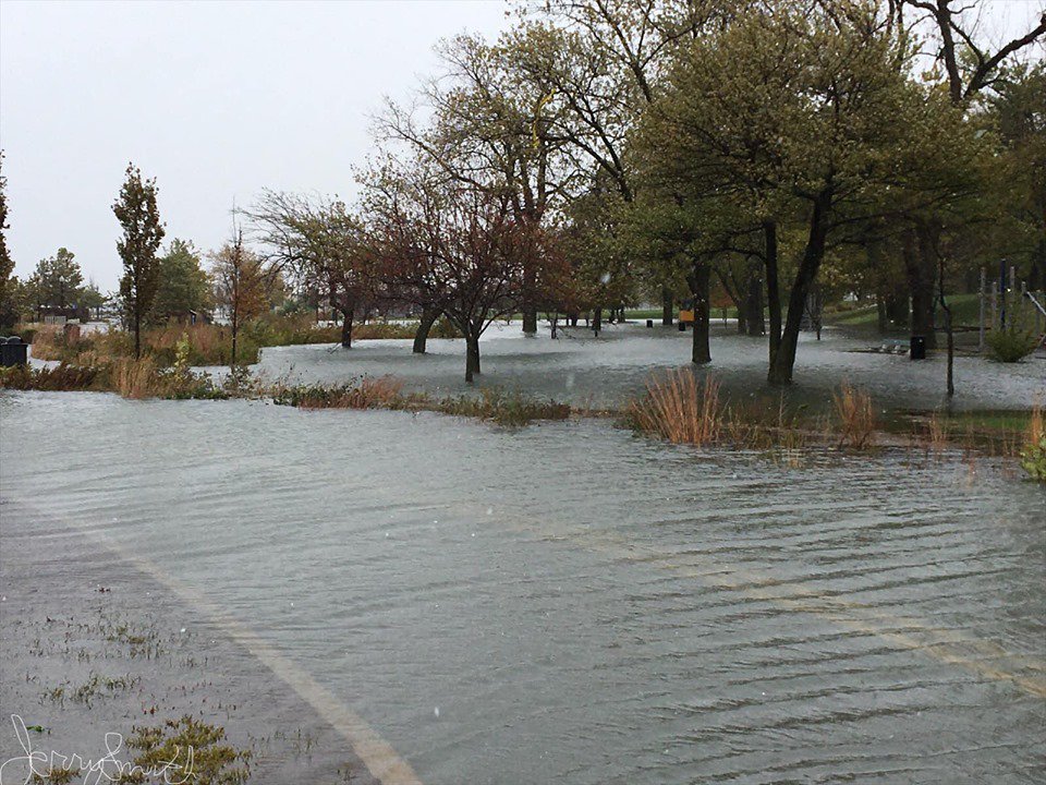
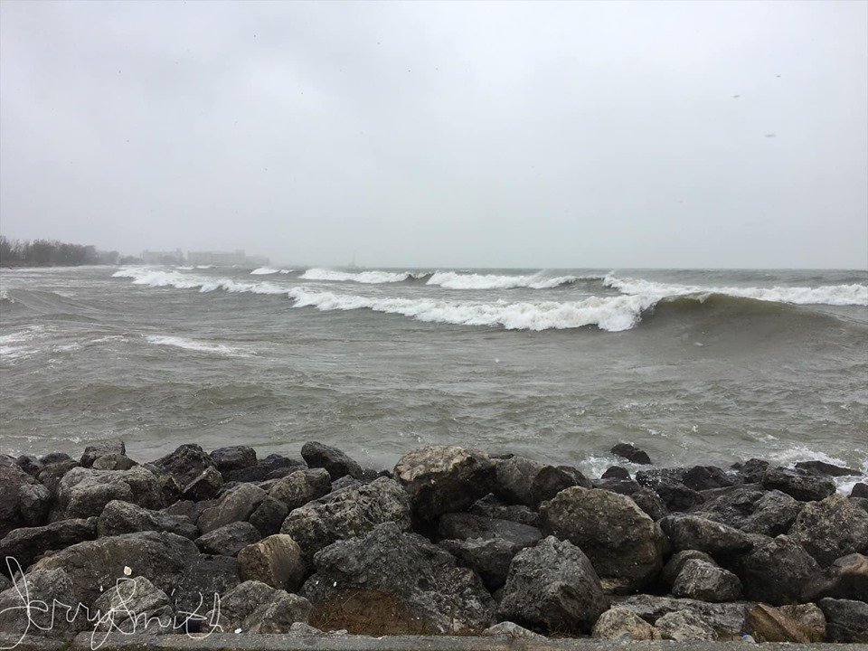
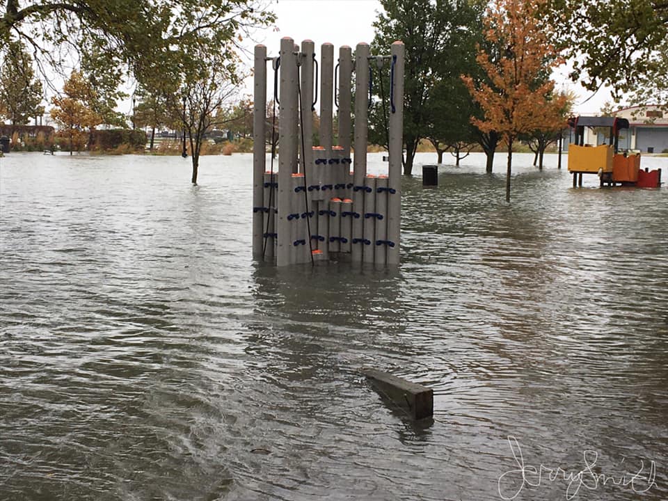
Lakeshore Flooding
Strong onshore winds and high lake levels combined for lakeshore flooding on shores of northeast Illinois and northwest Indiana. These are a few photos.
Juneway Beach in Rogers Park, Illinois (Cook County, IL - north side of Chicago)
 |
 |
 |
||||
| Photos from David Seal | ||||||
Whiting, Indiana (Lake County IN)
 |
 |
 |
||||
| Photos from Jerry Robert Smith | ||||||
Other
Links
 |
Media use of NWS Web News Stories is encouraged! Additional recaps can be found on the NWS Chicago Science & Past Events Page. |
|