Severe Weather Episode on the South Plains
|
 |
|
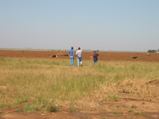
An outbreak of severe thunderstorms occurred across portions of the Texas Panhandle and the South Plains of West Texas from the early afternoon of Thursday, May 12, 2005 into the early morning hours of Friday, May 13. The weather pattern on this day was highly conducive for severe thunderstorms, specifically, very large hail and tornado development. A southward moving cold front early in the day became nearly stationary by afternoon as a strong flow of moisture overspread the area from the southeast. Numerous waves of severe thunderstorms developed throughout the afternoon Thursday and continued well into the after midnight hours on Friday. During this long duration event, and between the hours of 4:30 pm and 10:00 pm, several tornadoes occurred across the area. Additionally, very large hail reports were received throughout the event, including a number of tennis to baseball-size hail reports, and even a couple of softball-size hail reports. See the local storm report for a more complete list of the hail events. The National Weather Service (NWS) in Lubbock dispatched a damage survey team to assess reports of tornadoes and associated damage. As a more detailed review of radar data and storm video occurs in the coming days, slight modifications to the assessment can be expected. However, the following is composed from an accurate account of the survey team findings. The survey team was conducted on Friday, May 13, 2005, by the following NWS Lubbock personnel: Meteorologist-in-Charge Justin Weaver, Warning Coordination Meteorologist Brian LaMarre, and Senior Service Hydrologist John Lipe.
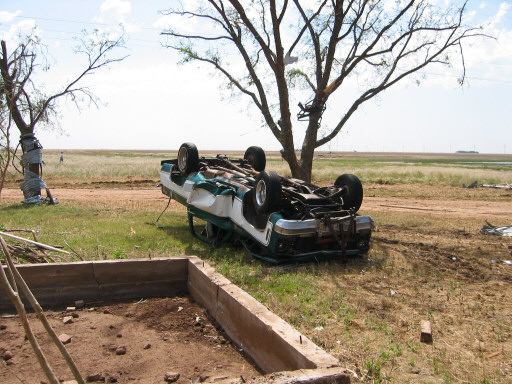
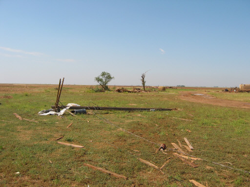
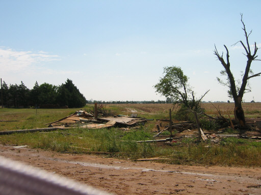
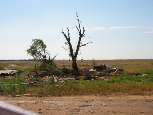
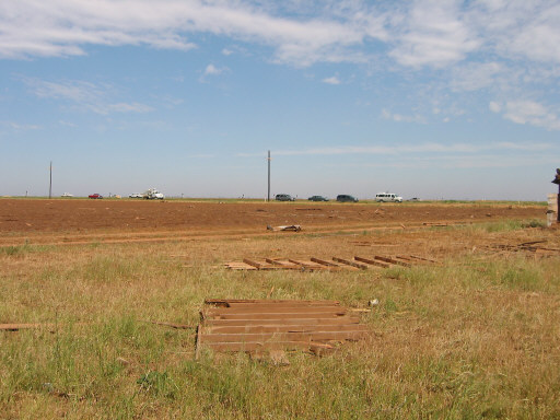
Pictures of damage from the first of two tornadoes to impact Ralls, TX. Click on the images for a larger view. (Photographs taken by Brian LaMarre, Warning Coordination Meteorologist, WFO Lubbock, TX) The above images depict damage from the first of two tornadoes to impact Ralls, TX on the night of May 12, 2005. The tornado tracked from 9 miles to the southwest of Ralls for six miles and impacted the area seen in the photographs. A 2,500 square foot residence was destroyed resulting in widespread F-2 and isolated lower F-3 damage (Click here to learn about the Fujita tornado intensity scale or F-scale for short). The tornado lifted the home off its foundation and scattered debris a few yards to the north and northeast. Some debris from the home was blown over a mile to the north and northeast. Two pick-up trucks were tossed into the air and demolished when deposited upside down. One vehicle was tossed for several yards before making contact with the surface. Trees were mud-splattered and stripped of leaves and bark with large branches completely torn off from trunks. Fortunately, no one was home at the time the tornado struck this area - between 8:40 PM and 8:55 PM.
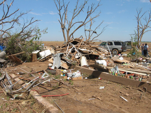
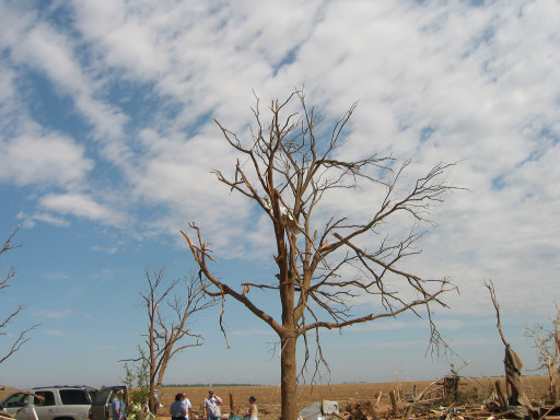
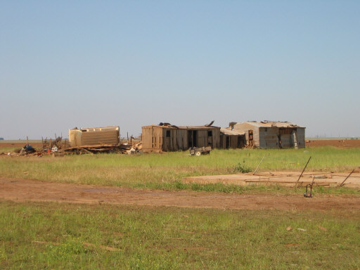
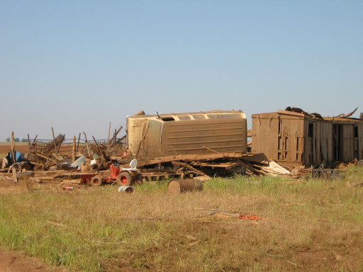
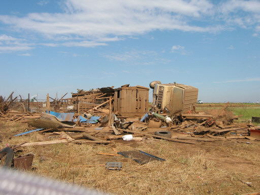
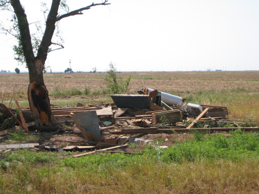
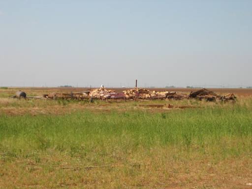
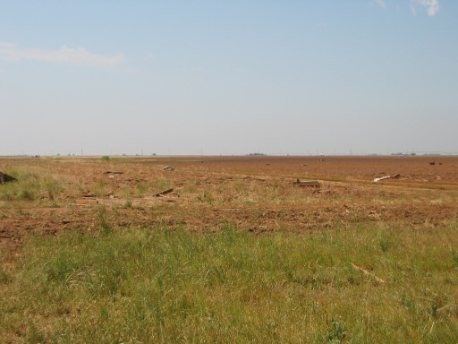
Pictures of damage from the second of two tornadoes to impact Ralls, TX. Click on the image for a larger view. (Photographs taken by Brian LaMarre, Warning Coordination Meteorologist, WFO Lubbock, TX) These images depict damage from the second of two tornadoes to impact Ralls, TX on the night of May 12, 2005. The tornado developed approximately 1.5 miles to the west of Ralls and tracked to the north and northwest before dissipating three miles north of Ralls. The occurrence of this second tornado in relation to the weakening of the first and stronger tornado is not uncommon with long-lived tornadic supercells. This pattern is typical of a cyclic tornado when one tornado weakens and lifts while another tornado forms to the right of the original tornado path. This tornado produced extensive F-1 and isolated F-2 damage. A residence was damaged and a barn completely destroyed with a vehicle blown over and deposited on its side. The damage seen in the photos is south of U.S. Highway 62/82. As the tornado tracked to the northeast over this area, 2000 lb bales of hay were tossed from a field on one side of the highway into a field across the highway to the south where the structures, power poles and vehicle were damaged. For a more complete account of the tornado activity on May 12th, read the public information statement below.
PUBLIC INFORMATION STATEMENT...UPDATED. ...DAMAGE SURVEY CONDUCTED FOR MAY 12 2005... UPDATED SOUTH PLAINS AND RALLS TORNADO INFORMATION. AN OUTBREAK OF SEVERE THUNDERSTORMS OCCURRED ACROSS PORTIONS OF THE THE WEATHER PATTERN ON THIS DAY WAS HIGHLY CONDUCIVE FOR SEVERE NUMEROUS WAVES OF SEVERE THUNDERSTORMS DEVELOPED THROUGHOUT THE THE NATIONAL WEATHER SERVICE IN LUBBOCK DISPATCHED A DAMAGE SURVEY IN CHRONOLOGICAL ORDER... 1. 430 PM...LAMB COUNTY...1 MILE WEST OF OLTON. 2. 504 PM...HALE COUNTY...1 MILE NORTH OF PLAINVIEW. 3. 541 PM...HALE COUNTY...10 MILES NORTHEAST OF PLAINVIEW. 4. 613 PM TO 625 PM...FLOYD COUNTY...SOUTH PLAINS. THIS TORNADO WAS THE PARENT OR MAIN TORNADO INVOLVED IN WHAT IS KNOWN 5. 624 PM TO 640 PM...FLOYD COUNTY...SOUTH PLAINS. 6. 840 PM TO 855 PM...CROSBY COUNTY...RALLS. 7. 855 PM TO 910 PM...CROSBY COUNTY...RALLS. 8. 920 PM TO 940 PM...LUBBOCK COUNTY...7 MILES NORTHWEST OF IDALOU. FOR REFERENCE...THE FUJITA TORNADO INTENSITY SCALE IS BASED ON F0...40 TO 72 MPH THE NATIONAL WEATHER SERVICE WOULD LIKE TO THANK ALL OF OUR LOCAL BRIAN LAMARRE Note: The below information contains preliminary reports as they were received throughout the severe weather event. Some reports may show multiple reports of tornadoes. This can occur as various sources witness the same tornado from different locations at different times. The official account of tornado occurrences across the area during the event can be seen in the above Public Information Statement. However, all reports are important to the National Weather Service and a sample of them can be seen below.
|
||||||||||||||||||||
|
PRELIMINARY LOCAL STORM REPORTS (in CDT):
..TIME...   ...EVENT...      ...CITY LOCATION...     ...LAT.LON...
..DATE...   ....MAG....      ..COUNTY LOCATION..ST.. ...SOURCE....
            ..REMARKS..

0145 PM     HAIL             8 E HALFWAY             34.19N 101.81W
05/12/2005  3.00 INCH        HALE               TX   TRAINED SPOTTER

            2 TO 3 INCH HAIL ALMOST COVERING THE GROUND

0155 PM     HAIL             PLAINVIEW               34.19N 101.72W
05/12/2005  1.00 INCH        HALE               TX   PUBLIC

            NICKEL TO QUARTER SIZE HAIL REPORTED ON NORTHWEST SIDE OF
            CITY.

0200 PM     TORNADO          1 S PLAINVIEW           34.18N 101.72W
05/12/2005                   HALE               TX   TRAINED SPOTTER

            TORNADO REPORTED SOUTH OF PLAINVIEW AIRPORT.

0200 PM     HAIL             PLAINVIEW               34.19N 101.72W
05/12/2005  2.00 INCH        HALE               TX   PUBLIC

            ONE TO TWO INCH HAIL REPORTED VIA INTERNET BY PUBLIC ON
            SOUTH SIDE OF CITY.

0215 PM     HAIL             PLAINVIEW               34.19N 101.72W
05/12/2005  1.75 INCH        HALE               TX   EMERGENCY MNGR

            GOLFBALL SIZE HAIL REPORTED BY EOC...EASTERN CITY LIMITS
            POWER OUTAGES ALSO REPORTED.

0220 PM     TORNADO          3 SE PLAINVIEW          34.16N 101.69W
05/12/2005                   HALE               TX   STORM CHASER

            TORNADO LOCATED 3 MILES SOUTHEAST OF THE PLAINVIEW
            AIRPORT.

0345 PM     HAIL             9 N LOCKNEY             34.25N 101.44W
05/12/2005  4.25 INCH        FLOYD              TX   STORM CHASER

            SOFTBALL SIZE HAIL REPORTED IN LONESTAR

0355 PM     TORNADO          7 NW SOUTH PLAINS       34.30N 101.40W
05/12/2005                   FLOYD              TX   TRAINED SPOTTER

            6 MILES WEST OF INTERSECTION OF 207 AND CR A OR 2 MILES
            NORTH OF LONE STAR. BRIEF TOUCHDOWN...NO DAMAGE COULD BE
            SEEN.

0410 PM     HAIL             OLTON                   34.18N 102.14W
05/12/2005  1.00 INCH        LAMB               TX   FIRE DEPT/RESCUE

0415 PM     HAIL             OLTON                   34.18N 102.14W
05/12/2005  1.75 INCH        LAMB               TX   FIRE DEPT/RESCUE

0449 PM     HAIL             EDMONSON                34.28N 101.89W
05/12/2005  1.75 INCH        HALE               TX   LAW ENFORCEMENT

0510 PM     HAIL             KRESS                   34.37N 101.75W
05/12/2005  1.00 INCH        SWISHER            TX   CO-OP OBSERVER

0517 PM     HAIL             DIMMITT                 34.55N 102.32W
05/12/2005  1.00 INCH        CASTRO             TX   TRAINED SPOTTER

0517 PM     TORNADO          7 S SILVERTON           34.37N 101.30W
05/12/2005                   BRISCOE            TX   TRAINED SPOTTER

            TORNADO TOUCHED DOWN AT 517 PM AND WAS ON THE GROUND
            UNTIL 525 PM. DAMAGED POWER POLES AND TREES.

0531 PM     HAIL             2 N SOUTH PLAINS        34.25N 101.31W
05/12/2005  4.25 INCH        FLOYD              TX   TRAINED SPOTTER

            1/2 MILE EAST OF INTERSECTION OF 207 AND FM 689

0531 PM     TORNADO          4 NW SOUTH PLAINS       34.27N 101.36W
05/12/2005                   FLOYD              TX   TRAINED SPOTTER

            ABOUT 3 MILES SW OF INTERSECTION OF CR A AND CR 8.
            TORNADO ON THE GROUND FOR ABOUT ONE MINUTE.

0535 PM     HAIL             TAHOKA                  33.16N 101.79W
05/12/2005  1.00 INCH        LYNN               TX   PUBLIC

0541 PM     TORNADO          11 NE PLAINVIEW         34.30N 101.59W
05/12/2005                   HALE               TX   TRAINED SPOTTER

0600 PM     HAIL             6 E KRESS               34.37N 101.64W
05/12/2005  3.00 INCH        SWISHER            TX   CO-OP OBSERVER

            2-3 INCH HAIL REPORTED

0607 PM     HAIL             10 S SILVERTON          34.33N 101.30W
05/12/2005  1.25 INCH        BRISCOE            TX   LAW ENFORCEMENT

0617 PM     TORNADO          3 NNW SOUTH PLAINS      34.26N 101.33W
05/12/2005                   FLOYD              TX   TRAINED SPOTTER

0620 PM     HAIL             SOUTH PLAINS            34.22N 101.31W
05/12/2005  3.00 INCH        FLOYD              TX   STORM CHASER

            3 INCH HAIL REPORTED NEAR SOUTH PLAINS

0630 PM     TORNADO          10 SW QUITAQUE          34.26N 101.18W
05/12/2005                   FLOYD              TX   NWS EMPLOYEE

0637 PM     HAIL             3 NW WILSON             33.35N 101.76W
05/12/2005  0.75 INCH        LYNN               TX   TRAINED SPOTTER

0650 PM     HAIL             1 E QUITAQUE            34.37N 101.04W
05/12/2005  1.75 INCH        BRISCOE            TX   EMERGENCY MNGR

0650 PM     HAIL             SLATON                  33.44N 101.64W
05/12/2005  1.00 INCH        LUBBOCK            TX   FIRE DEPT/RESCUE

0705 PM     HAIL             3 SE WOODROW            33.42N 101.81W
05/12/2005  1.75 INCH        LUBBOCK            TX   TRAINED SPOTTER

            GOLFBALL SIZE HAIL REPORTED 1/2 MILE EAST OF THE
            INTERSECTION OF HIGHWAY 87 AND 41

0714 PM     HAIL             2 N QUITAQUE            34.40N 101.06W
05/12/2005  2.75 INCH        BRISCOE            TX   EMERGENCY MNGR

0735 PM     HAIL             RANSOM CANYON           33.53N 101.68W
05/12/2005  1.75 INCH        LUBBOCK            TX   LAW ENFORCEMENT

0801 PM     HAIL             2 E RANSOM CANYON       33.53N 101.65W
05/12/2005  2.50 INCH        LUBBOCK            TX   BROADCAST MEDIA

            LOCATED AT BUFFALO SPRINGS.

0804 PM     HAIL             PLAINVIEW               34.19N 101.72W
05/12/2005  1.75 INCH        HALE               TX   LAW ENFORCEMENT

            FLOODING ALSO REPORTED IN PLAINVIEW

0815 PM     TSTM WND GST     6 SE LUBBOCK            33.51N 101.80W
05/12/2005  60 MPH           LUBBOCK            TX   PUBLIC

            ROOF BLOWN OFF A CONVENIENT STORE.

0817 PM     HAIL             PLAINVIEW               34.19N 101.72W
05/12/2005  1.00 INCH        HALE               TX   LAW ENFORCEMENT

0840 PM     TORNADO          2 S LORENZO             33.64N 101.54W
05/12/2005                   CROSBY             TX   FIRE DEPT/RESCUE

0850 PM     TORNADO          5 W RALLS               33.68N 101.47W
05/12/2005                   CROSBY             TX   FIRE DEPT/RESCUE

            TWO TORNADOES BETEEN RALLS AND LORENZO AS REPORTED BY
            RALLS FIRE DEPT

0850 PM     HAIL             RALLS                   33.68N 101.38W
05/12/2005  1.75 INCH        CROSBY             TX   FIRE DEPT/RESCUE

            REPORTED BY RALLS FIRE DEPT

0856 PM     HAIL             9 E ABERNATHY           33.84N 101.69W
05/12/2005  0.75 INCH        HALE               TX   STORM CHASER

0900 PM     TORNADO          RALLS                   33.68N 101.38W
05/12/2005                   CROSBY             TX   EMERGENCY MNGR

            POWER LINES DOWN AND HOMES DAMAGED 1/2 MILE WEST OF RALLS


0900 PM     TSTM WND GST     2 W RALLS               33.68N 101.42W
05/12/2005  70 MPH           CROSBY             TX   TRAINED SPOTTER

            POWER LINES DOWN. WIND SPEED ESTIMATED

0912 PM     HAIL             10 W ESTELLINE          34.55N 100.61W
05/12/2005  2.00 INCH        HALL               TX   PUBLIC

            AT PARNELL COMMUNITY

0950 PM     HAIL             1 N NEW DEAL            33.75N 101.84W
05/12/2005  2.50 INCH        LUBBOCK            TX   TRAINED SPOTTER

0954 PM     TORNADO          7 NW IDALOU             33.73N 101.60W
05/12/2005                   LUBBOCK            TX   STORM CHASER

            BRIEF TORNADO

0955 PM     HAIL             10 N CHILDRESS          34.57N 100.25W
05/12/2005  0.88 INCH        CHILDRESS          TX   TRAINED SPOTTER

1005 PM     HAIL             NEW DEAL                33.73N 101.84W
05/12/2005  2.75 INCH        LUBBOCK            TX   LAW ENFORCEMENT

            REPORTED AT INTERSECTION OF COUNTY ROAD 5300 AND
            INTERSTATE 27.

1010 PM     HAIL             5 E PETERSBURG          33.87N 101.51W
05/12/2005  1.00 INCH        FLOYD              TX   PUBLIC

1023 PM     HAIL             5 S FLOYDADA            33.91N 101.34W
05/12/2005  0.88 INCH        FLOYD              TX   LAW ENFORCEMENT

1033 PM     HAIL             4 W NEW DEAL            33.73N 101.91W
05/12/2005  1.50 INCH        LUBBOCK            TX   TRAINED SPOTTER

1041 PM     HAIL             4 S FLOYDADA            33.93N 101.34W
05/12/2005  1.00 INCH        FLOYD              TX   FIRE DEPT/RESCUE

1105 PM     HAIL             5 W DOUGHERTY           33.94N 101.17W
05/12/2005  1.75 INCH        FLOYD              TX   LAW ENFORCEMENT

            ALONG HIGHWAY 602

1118 PM     HAIL             ANTON                   33.81N 102.16W
05/12/2005  1.75 INCH        HOCKLEY            TX   BROADCAST MEDIA

1145 PM     HAIL             ROARING SPRINGS         33.90N 100.86W
05/12/2005  1.75 INCH        MOTLEY             TX   LAW ENFORCEMENT

1204 AM     HAIL             8 NW ABERNATHY          33.92N 101.95W
05/13/2005  1.00 INCH        HALE               TX   LAW ENFORCEMENT

1230 AM     HAIL             CONE                    33.80N 101.39W
05/13/2005  2.00 INCH        CROSBY             TX   STORM CHASER

1244 AM     HAIL             7 S PLAINVIEW           34.09N 101.72W
05/13/2005  1.75 INCH        HALE               TX   LAW ENFORCEMENT

0115 AM     HAIL             1 SW LOCKNEY            34.11N 101.45W
05/13/2005  1.75 INCH        FLOYD              TX   FIRE DEPT/RESCUE

0212 AM     HAIL             5 W PADUCAH             34.01N 100.39W
05/13/2005  1.00 INCH        COTTLE             TX   FIRE DEPT/RESCUE

0230 AM     HAIL             4 E PADUCAH             34.01N 100.23W
05/13/2005  1.75 INCH        COTTLE             TX   AMATEUR RADIO
|
||||||||||||||||||||


