
Flash flooding threatens areas from the Tennessee Valley to the Carolinas as storms repeat along a stalled front. Monsoonal storms may trigger flooding in the Southwest. Dangerous heat expands across the Desert Southwest, Plains, mid-Mississippi Valley and Southern Tier. Critical fire weather for interior Pacific Northwest. Cooler, drier air brings brief relief to the Great Lakes and Northeast. Read More >
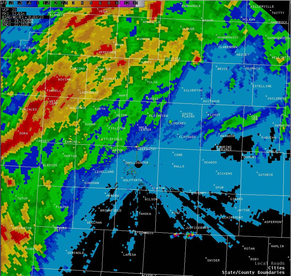
Image of the storm total precipitation (in inches), as estimated by radar, that fell across the region from the afternoon of Friday, August 19th through the morning on Monday, August 22th. Click on the image for a larger view.
Similar to a weekend earlier, a cold front moving in the area, numerous outflow boundaries, a number of upper level disturbances, relatively slow storm movement, and an unusually moist air mass in place, combined to produce heavy precipitation across the northwest South Plains and southern Texas Panhandle from Friday, August 19, through Monday, August 22th. However, unlike the previous weekend, the cold front, along with the mid-level moisture plume, were unable to push south through the South Plains. This resulted in most of the heavy precipitation remaining over the northern and western portions of the Lubbock County Warning Area (CWA), with much of the remainder of the South Plains and most of the Rolling Plains receiving very little rainfall.
The heaviest observed rainfall fell at Muleshoe, where 4 inches of rain was recorded. Other notable amounts were: Muleshoe 2S mesonet with 3.17 inches; Amherst 1NE mesonet with 2.33 inches; Dimmitt with 2.22 inches; and Olton with 2.15 inches. Numerous other locations in the area reported between one and two inches (see the Tables below). Additionally, the radar rainfall estimates (see the image at the top) suggest that even heavier amounts of precipitation, from 5 to 6 inches plus, fell west of Muleshoe, from Bovina to West Camp and then southwest into New Mexico. However, no ground truth rain gage observations were received to confirm/refute the extremely heavy rain indicated by radar over western Parmer and northwest Bailey counties.
Below are the 3 day rainfall totals from the National Weather Service COOP observer sites from the morning of August 19th through the morning of the 22nd. Locations with rainfall totals over one inch are highlighted in yellow, with amounts greater than two inches highlighted in red.
|
West Texas Mesonet Site
|
Rainfall Total (inches)
|
| Abernathy |
0.93
|
| Aspermont |
0
|
| Big Spring |
0
|
| Brownfield |
0
|
| Childress |
0
|
| Crosbyton |
0
|
| Denver City |
1.10
|
| Dimmitt |
2.22
|
| Floydada |
T
|
| Friona |
1.71
|
| Guthrie |
0
|
| Hart |
1.27
|
| Hereford |
1.94
|
| Jayton |
0
|
| Lamesa |
0
|
| Levelland |
0.62
|
| Littlefield |
0.94
|
| Lubbock Airport |
T
|
| Matador |
0.45
|
| Memphis |
0.24
|
| Morton |
1.09
|
| Muleshoe |
4.00
|
| Olton |
2.15
|
| Paducah |
0.02
|
| Paducah 15S |
0.06
|
| Plainview Water Plant |
0.93
|
| Plainview Daily Herald |
1.63
|
| Post |
0
|
| Seminole |
0.02
|
| Silverton |
0.13
|
| Snyder |
0
|
| Spur |
0
|
| Tahoka |
0.02
|
| Tulia |
1.36
|
| Turkey |
0
|
| Vigo Park |
1.65
|
| White River Lake |
0
|
Below are the 3 day rainfall totals for the West Texas Mesonet sites from the morning of August 19th through the morning of the 22nd. Locations with rainfall totals over one inch are highlighted in yellow, with amounts greater than two inches highlighted in red.
|
West Texas Mesonet Site
|
Rainfall Total (inches)
|
| Abernathy 5NE |
0.98
|
| Amherst 1NE |
2.33
|
| Anton 6S |
1.35
|
| Aspermont 3NE |
0
|
| Brownfield 2S |
0
|
| Clarendon 2W |
0.37
|
| Denver City 7W |
1.51
|
| Dimmitt 2NE |
1.73
|
| Floydada 2NE |
0.12
|
| Fluvanna 3W |
0
|
| Friona 2NE |
1.43
|
| Gail 2SE |
0
|
| Goodlett 3W |
0.32
|
| Graham 5SW (MACY) |
0
|
| Guthrie 10W (PITC) |
0
|
| Hart 3N |
1.81
|
| Hereford 2NW |
1.54
|
| Jayton 1S |
0
|
| Lamesa 2SE |
0
|
| Levelland 4S |
0.51
|
| Lubbock 3W |
0
|
| McLean 1E |
0.41
|
| Memphis 1NE |
0.24
|
| Morton 1NE |
1.06
|
| Muleshoe 2S |
3.17
|
| O'Donnell 1N |
0
|
| Olton 6S |
1.17
|
| Paducah 10SW |
0
|
| Pampa 2E |
1.12
|
| Plains 3N |
1.32
|
| Plainview 1S |
1.34
|
| Post 1S |
0
|
| Ralls 1SE |
0
|
| Reese Center |
0.06
|
| Roaring Springs 3N |
0.06
|
| Seagraves 1SW |
0.06
|
| Seminole 2N |
0
|
| Silverton 7E |
0.04
|
| Slaton 2NE |
0
|
| Snyder 3E |
0
|
| Spur 1W |
0
|
| Sundown 8SW (MALL) |
0.24
|
| Tahoka 3NE |
0
|
| Tulia 2NE |
1.46
|
| White River Lake 6NW |
0
|

