
Dangerous heat will expand from the Gulf Coast into the Southern Plains and Desert Southwest through week's end. Additional extreme heat impacting the Pacific Northwest will shift to the northern Plains by the weekend. Tropical Storm Bertha is expected to continue to impact portions of the northern Gulf Coast from the western Florida Panhandle to southeastern Louisiana through tonight. Read More >
|
Storms Bring Rain and Severe Weather |
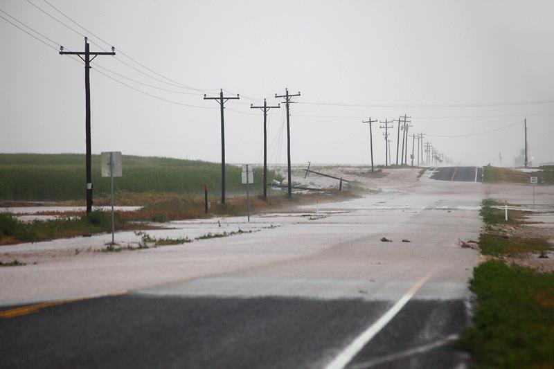 |
| Photo taken in western Castro county along FM 1055 southwest of Dimmitt Monday evening (20 August 2012). Power poles were snapped by strong thunderstorm winds, estimated at 70-80 mph. In addition, localized rainfall amounts in excess of 3-4" resulting in flooding. Photo courtesy of Matt Ziebell. Click on the picture for a larger view. |
| An upper level disturbance combined forces with a warm front and a sufficiently hot and moist air mass to bring widespread showers and thunderstorms to the South Plains region. Isolated strong and severe thunderstorms initially developed during the late afternoon and early evening hours across the southwest Texas Panhandle. These isolated storms moved very slowly and produced heavy rain, large hail and damaging winds. One particularly intense storm snapped power poles and dumped torrential rains southwest of Dimmitt (see the above picture). Hail also shredded crops near the community of Flagg. |
|
|
| 3D radar view of a very intense thunderstorm over southwestern Castro County Monday evening (20 August 2012). This storm dumped very heavy rain and produced damaging winds and hail southwest of Dimmitt. Click on the image for a bigger view. |
| A faster moving severe storm also developed over Parmer County and generated damaging wind gusts as it moved across Friona. The West Texas Mesonet (WTM) station located 2 miles northeast of Friona, at the airport, measured a wind gust to 88 mph. The strong winds damaged a hanger door at the airport and flipped over two quarter mile long irrigation pivots just to the east of the WTM station. |
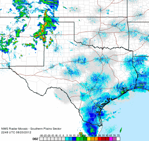 |
| Regional radar mosaic valid from 5:48 to 6:58 pm on Monday evening (20 August 2012). |
|
The isolated strong and severe thunderstorms across the southwest Texas Panhandle were eventually overtaken by a larger area of thunderstorm that moved out of northeast New Mexico. After this happened, the large hail threat diminished, but the damaging wind threat did continue well into the late evening hours as the complex of thunderstorms moved rapidly to the southeast. The strongest straight-line winds from this complex took aim on the Amarillo area, where several wind gusts between 74 and 78 mph were recorded. The winds weren't as intense further south, but gusts to 58 mph were observed by the WTM site 2 miles west-southwest of Turkey as well as at the Lubbock Airport during the late evening hours. To view the preliminary storm reports for NWS Lubbock's area of responsibility for this event CLICK HERE. |
|
|
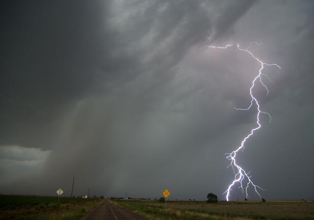
| Picture of a storm moving through southern Lamb and northern Hockley Counties Monday evening (20 August). Photo courtesy of Mark Conder. Click on the image for a larger view. |
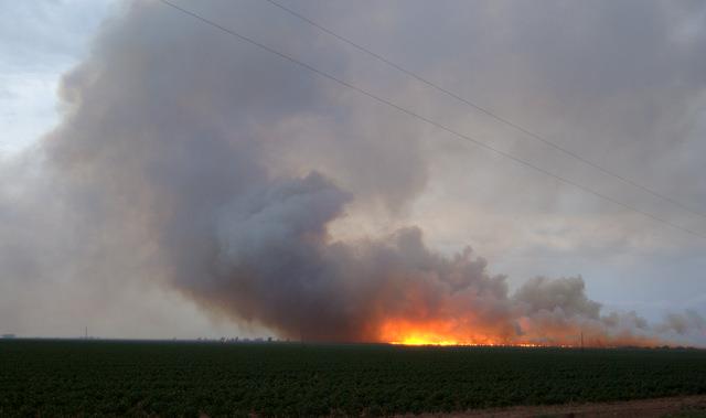
| The storms also generated a tremendous amount of lightning in spots (above). Unfortunately, this lightning did spark a few wildfires, including a large fire near the community of Pep in northwest Hockley County (below). |
|
|
| Wildfire sparked by lightning near Pep on Monday evening (20 August 2012). Image courtesy of Mark Conder. Click on the picture for a larger view. |
| The thunderstorm complex continued to produce gusty winds along its leading edge into the late evening hours, though the severe gusts (58 mph or greater) ended. More importantly, this large complex of storms brought widespread rainfall to the South Plains, Rolling Plains and Texas Panhandle, with rain showers lingering through the night. |
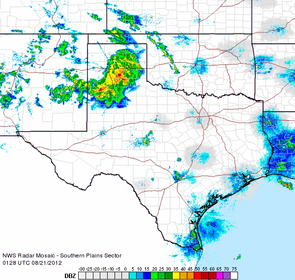 |
| Regional radar mosaic valid from 8:28 to 9:38 pm on Monday evening (20 August 2012). |
| The rainfall was not a drought buster, but it did bring welcome precipitation to the entire region. As the below image illustrates, the heaviest rain (1/2" to 1"+) fell from west of Dimmitt to west of Littlefield, as well as across much of the southeast Texas Panhandle into the northern Rolling Plains. |
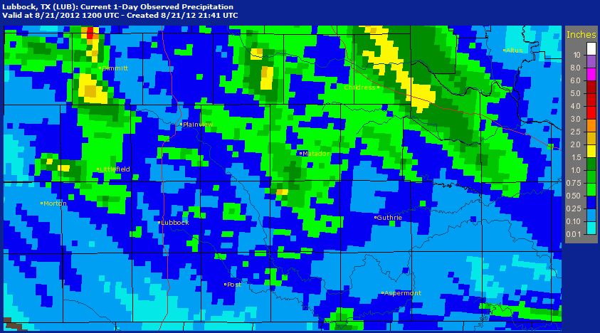 |
| Bias-corrected radar estimated 24-hour rainfall totals valid ending at 7 am Tuesday (21 August 2012). Click on the graphic for a bigger view. |
| Even outside the heaviest areas of rain, most spots received between 1/10 and 1/2 an inch of rain. The WTM site just north of Childress was the big winner, tallying 1.92 inches, while the Childress Airport officially recorded 0.66 inches. The Lubbock Airport officially measured 0.36 inches, with totals around town ranging from around a quarter inch to just over a half inch. |
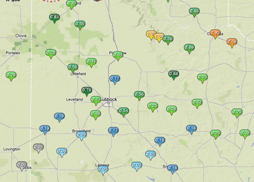 |
| West Texas Mesonet 24-hour rainfall totals ending at 5 pm on Tuesday (21 August 2012). Click on the map for a larger view. |
| An interactive graphical plot of severe storm reports and rainfall totals for this event can be found below. |
|
|
|||
|
Preliminary storm reports from the Monday evening (20 August 2012). Click on the weather icons to view the full report. Rainfall reports are courtesy of the West Texas Mesonet.
|
|||
|
Toggle Preliminary Storm Reports from 20 August 2012
|
Toggle 24 Hour Rainfall ending at 6:30 pm on 21 August 2012
|
Toggle 48 Hour Rainfall ending at 6:30 pm on 21 August 2012
|
|


