
Dangerous heat will expand from the Gulf Coast into the Southern Plains and Desert Southwest through week's end. Additional extreme heat impacting the Pacific Northwest will shift to the northern Plains by the weekend. Tropical Storm Bertha is expected to continue to impact portions of the northwestern Gulf Coast from south central Louisiana to the upper Texas coast today. Read More >

An intense spring storm system brought severe thunderstorms, cold air, heavy snow and strong winds to the region during the last weekend of April. After a warm Friday (28 April 2017), a strong cold front moved through the South Plains Friday night. Temperatures tumbled from the 70s and 80s into the 40s and 50s quickly as the front moved through. Concurrently, the upper level storm system began organizing the southern Rockies.
 |
|
|
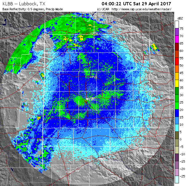
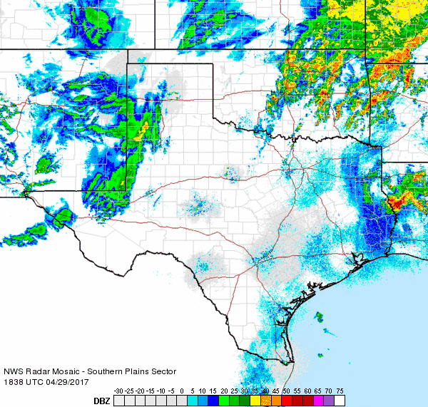
Radar animation valid from 11 pm on Friday April 28th to 11 am on Saturday April 29, 2017.
|
|
The first wave of lift with the developing upper level low over New Mexico moved out across West Texas late Friday night into Saturday morning. Even with relatively little moisture and weak instability, widely scattered strong and severe storms developed over the South Plains then raced northeastward into the Rolling Plains where greater moisture was available and storms increased in coverage. The most robust storms dropped hail as large as ping pong balls near Slaton at 2:17 am, quarter size hail northeast of Childress at 1:19 am and nickel size hail southeast of Floydada at 3:30 am. Where the storms repeatedly tracked over the same place a few locations also saw healthy rain totals in excess of 1 inch early Saturday morning. Just enough cold air even moved in to the southwest Texas Panhandle to briefly change the rain to snow around Rhea (in northwest Parmer County) where a quick tenth of an inch of snow was observed by 9 am Saturday.
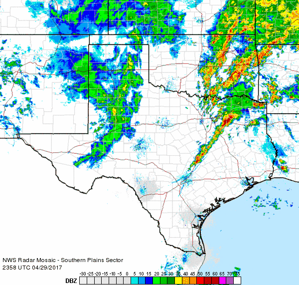
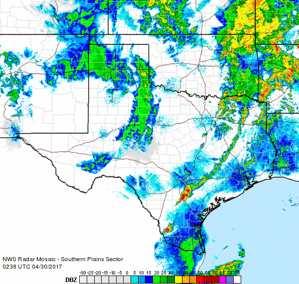
After a chilly and relatively dry stretch from late Saturday morning into early afternoon, another round of showers moved out of New Mexico and across the South and Rolling Plains late Saturday afternoon into Saturday evening. The rain also changed back to snow across the far southwest Texas Panhandle and northwestern South Plains Saturday evening before tapering off, with little to no accumulation noted at Dimmitt, Friona and Muleshoe. However, further north across the central and western Panhandles, a large shield of light to moderate snow developed and persisted Saturday evening/night into Sunday morning. Several inches to near a foot of snow fell over the western Panhandles before finally coming to an end Sunday afternoon.
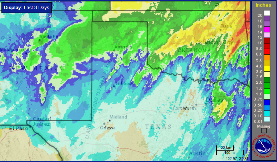
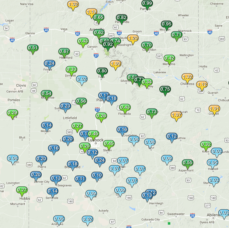
By the time the upper level low pulled away into Kansas on Sunday, the entire region has seen at least a little precipitation, as the above and below maps show. Rainfall totals of a tenth to quarter of an inch were fairly common, with a couple heavier of swaths in excess of 1 inch, one from west of Plainview to east of Tulia and another from northwest of Guthrie to Childress.
 |
|
|
West Texas Mesonet 2-day rain totals ending at 8 pm on Sunday 30 May 2017.
|
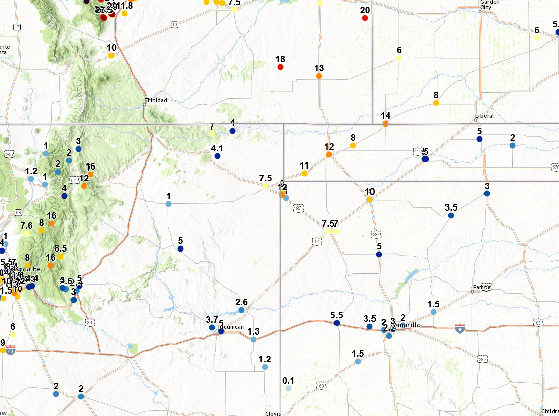
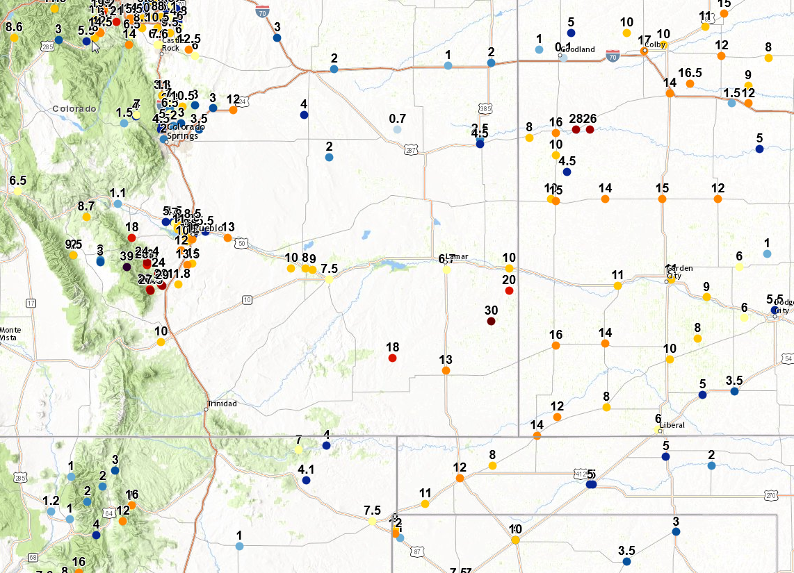
Where it was cold enough for snow, impressive totals were tallied from the Front Range of Colorado through their eastern Plains into northeast New Mexico, western Kansas and the western and central Oklahoma and Texas Panhandles. Several spots from western Kansas into southeast Colorado, as well as along the Front Range of Colorado, recorded in excess of 20 inches.
 |
|
|
Two-day snow totals ending on Sunday, 30 April 2017. To view 3-day snowfall totals ending 1 May 2017 and center further north into Colorado and Kansas CLICK HERE.
|
Even after the precipitation came to an end over the South Plains region, the intensifying storm system moving up into Kansas generated strong and severe wind gusts over much of the area during the day Sunday. Many locations along and north of Highway 84 Corridor experienced wind gusts of 45 to 55 mph, with several sites topping out in excess of 60 mph. The strongest winds impacted locations from Hart to Floydada to White River Lake, with a peak gust of 65 mph measured at the Hart West Texas Mesonet site at 12:25 pm. The winds finally subsided Sunday evening as the storm system continued to pull away from the region and toward the Midwest.
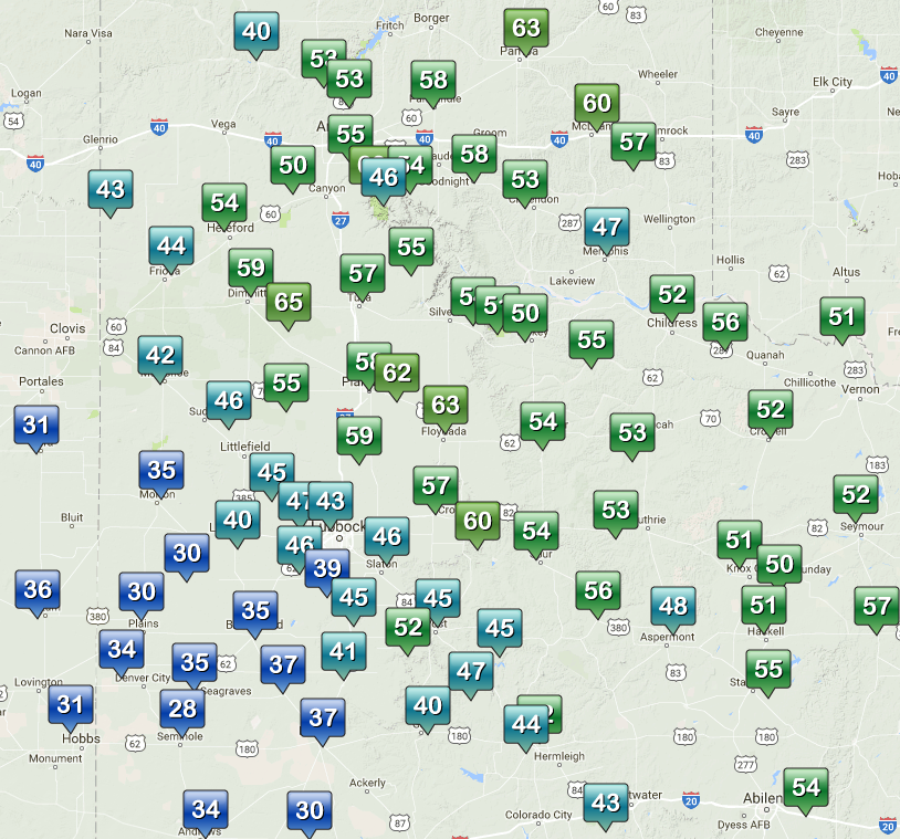
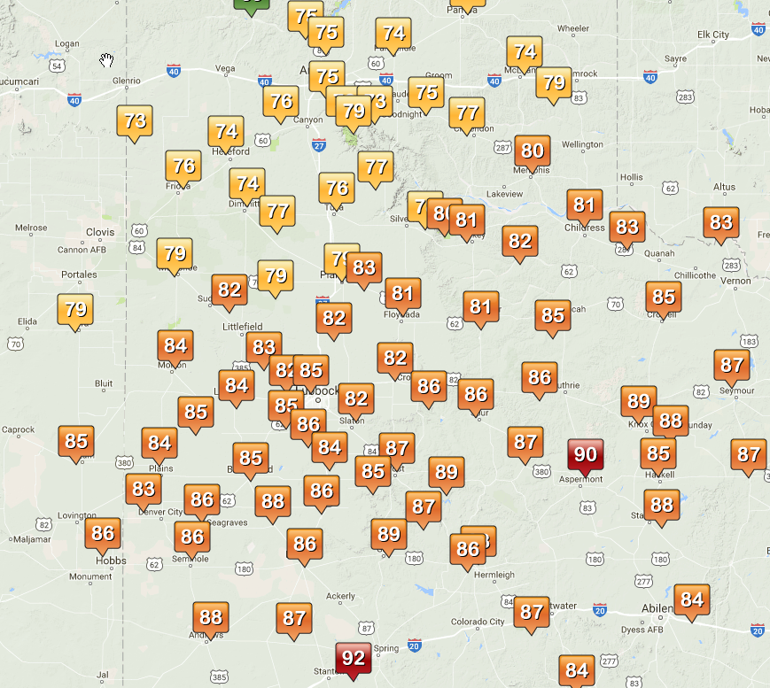
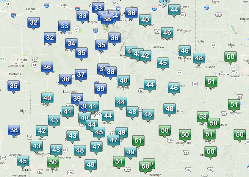
Though no record lows were set in West Texas this event, it did bring very chilly air for the final days of April. After highs in the 70s and 80s (and even a couple of low 90s) Friday afternoon, temperatures were stuck in the 30s and 40s for most spots during the day Saturday. A few spots north and west of Lubbock even dropped to or just below the freezing mark early Sunday before recovering into the 50s and 60s Sunday afternoon.
 |
 |
|
Highs temperatures on Friday, 28 April 2017 (left) contrasted by 11 am temperatures on Saturday 29 April 2017 (right). Data are courtesy of the West Texas Mesonet. Lows observed Sunday morning (30 April 2017) can be VIEWED HERE.
|
|
Below are the preliminary local storm reports, including maximum wind speeds and gusts and snow totals that were composed by NWS Lubbock and NWS Amarillo after the late April storm concluded.
PRELIMINARY LOCAL STORM REPORT...SUMMARY
NATIONAL WEATHER SERVICE LUBBOCK TX
841 PM CDT SUN APR 30 2017

..TIME...   ...EVENT...      ...CITY LOCATION...     ...LAT.LON...
..DATE...   ....MAG....      ..COUNTY LOCATION..ST.. ...SOURCE....
            ..REMARKS..

0820 AM     HIGH SUST WINDS  3 WSW AIKEN             34.13N 101.57W
04/30/2017  M40 MPH          HALE               TX   MESONET

            PEAK GUST OF 62 MPH AT 1217 PM. MEASURED BY THE WEST
            TEXAS MESONET.

0823 AM     HIGH SUST WINDS  VIGO PARK               34.65N 101.50W
04/30/2017  M43 MPH          SWISHER            TX   MESONET

            MEASURED BY THE WEST TEXAS MESONET.

0925 AM     HIGH SUST WINDS  2 NNE FLOYDADA          34.00N 101.33W
04/30/2017  M40 MPH          FLOYD              TX   MESONET

            MEASURED BY THE WEST TEXAS MESONET.

0930 AM     HIGH SUST WINDS  2 ENE TULIA             34.54N 101.74W
04/30/2017  M40 MPH          SWISHER            TX   MESONET

            MEASURED BY THE WEST TEXAS MESONET.

0940 AM     NON-TSTM WND GST 3 N HART                34.42N 102.11W
04/30/2017  M60 MPH          CASTRO             TX   MESONET

            SUSTAINED 45 MPH. PEAK GUST OF 65 MPH AT 1225 PM.
            MEASURED BY WEST TEXAS MESONET.

1010 AM     HIGH SUST WINDS  5 ENE ABERNATHY         33.88N 101.76W
04/30/2017  M41 MPH          HALE               TX   MESONET

            PEAK GUST OF 60 MPH AT 105 PM. MEASURED BY THE WEST
            TEXAS MESONET.

1040 AM     NON-TSTM WND GST 6 NW WHITE RIVER LAKE   33.53N 101.17W
04/30/2017  M58 MPH          CROSBY             TX   MESONET

            SUSTAINED 42 MPH. PEAK GUST OF 60 MPH AT 140 PM.
            MEASURED BY WEST TEXAS MESONET.

1045 AM     NON-TSTM WND GST 1 S PLAINVIEW           34.18N 101.71W
04/30/2017  M58 MPH          HALE               TX   MESONET

            MEASURED BY THE WEST TEXAS MESONET.

1050 AM     NON-TSTM WND GST 2 NE DIMMITT            34.57N 102.29W
04/30/2017  M59 MPH          CASTRO             TX   MESONET

            SUSTAINED 41 MPH. MEASURED BY THE WEST TEXAS MESONET.

1115 AM     NON-TSTM WND GST 1 S PLAINVIEW           34.16N 101.72W
04/30/2017  M58 MPH          HALE               TX   AWOS

            MEASURED BY THE PLAINVIEW AWOS.

1125 AM     NON-TSTM WND GST 2 W CHILDRESS           34.43N 100.28W
04/30/2017  M58 MPH          CHILDRESS          TX   ASOS

1200 PM     NON-TSTM WND GST 2 NNE FLOYDADA          34.00N 101.33W
04/30/2017  M58 MPH          FLOYD              TX   MESONET

            SUSTAINED 44 MPH. MEASURED BY THE WEST TEXAS MESONET.

1217 PM     NON-TSTM WND GST 3 WSW AIKEN             34.13N 101.57W
04/30/2017  M62 MPH          HALE               TX   MESONET

            MEASURED BY THE WEST TEXAS MESONET

1220 PM     NON-TSTM WND GST 2 NNE FLOYDADA          34.00N 101.33W
04/30/2017  M63 MPH          FLOYD              TX   MESONET

            MEASURED BY THE WEST TEXAS MESONET

1220 PM     HIGH SUST WINDS  6 S OLTON               34.09N 102.12W
04/30/2017  M40 MPH          LAMB               TX   MESONET

            MEASURED BY THE WEST TEXAS MESONET.

1225 PM     NON-TSTM WND GST 3 N HART                34.42N 102.11W
04/30/2017  M65 MPH          CASTRO             TX   MESONET

0105 PM     NON-TSTM WND GST 5 ENE ABERNATHY         33.88N 101.76W
04/30/2017  M59 MPH          HALE               TX   MESONET

            MEASURED BY THE WEST TEXAS MESONET

0140 PM     NON-TSTM WND GST 6 NW WHITE RIVER LAKE   33.53N 101.17W
04/30/2017  M60 MPH          CROSBY             TX   MESONET

            WEST TEXAS MESONET OBSERVATON

