| Widespread cold rain and freezing rain 16-17 January 2020 |
|||||||||||
 |
|||||||||||
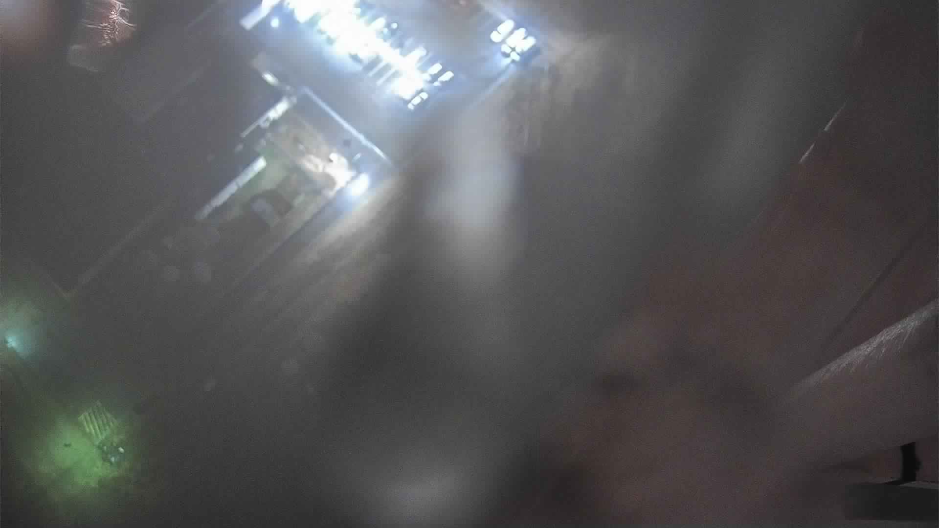
| Glazed-over webcam in Lubbock on Thursday evening (16 January 2020). The image is courtesy of KCBD. | |||||||||||
|
A couple of upper level disturbances joined forces with a cold front and moisture from the Gulf and the eastern Pacific Ocean to provide a couple of rounds of rain and freezing rain for West Texas. This came on the heels of two warm days, January 13th and 14th, when most locations experienced highs well into the 70s. The cold front followed on the 15th, though the coldest of the air didn't fully build into the region until early the next day. The initial frontal passage was dry, but that changed as moisture streamed over the frontal zone on Thursday (16 January 2020). |
|||||||||||
 |
|||||||||||
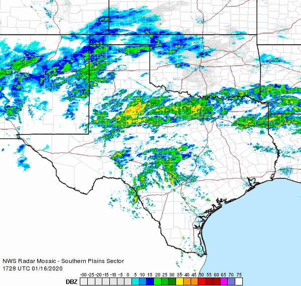
| Regional radar animation valid from 11:28 am to 12:38 pm on 16 January 2020. | |||||||||||
| Areas of rain blossomed over the Rolling Plains and adjacent South Plains late Thursday morning. Temperatures were in the 30s, though generally just above the freezing mark to start out. However, the rain-cooled air allowed many locations to drop to or just slightly below the freezing mark during the afternoon and evening. This caused any ongoing rain to become freezing rain. Temperatures reached their minimum late Thursday evening, in the upper 20s and lower 30s, before slowly moderating through Friday morning. | |||||||||||
 |
|||||||||||
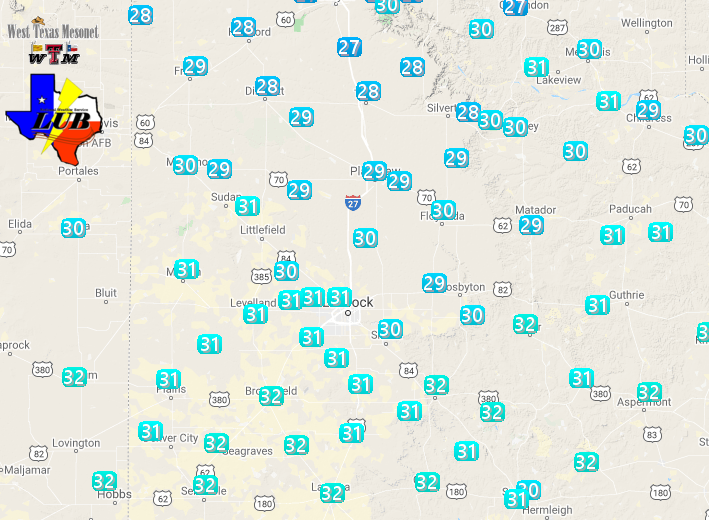
| Observed temperatures around 6:30 pm on Thursday evening (16 January 2020). The data are courtesy of the West Texas Mesonet. | |||||||||||
|
|||||||||||
| The freezing rain did accumulate, primarily on elevated surfaces like bridges, overpasses, vehicles, trees, fences and the grass. Officially, Lubbock recorded 0.13" of ice and Childress reported 0.25" of ice. Thankfully, most surface roads remained liquid because of the marginal temperatures (at or just slightly below freezing). However, one accident occurred on an icy bridge in Hale Center. Sadly, two children were ejected from the vehicle and were pronounced dead on the scene. | |||||||||||
 |
|||||||||||
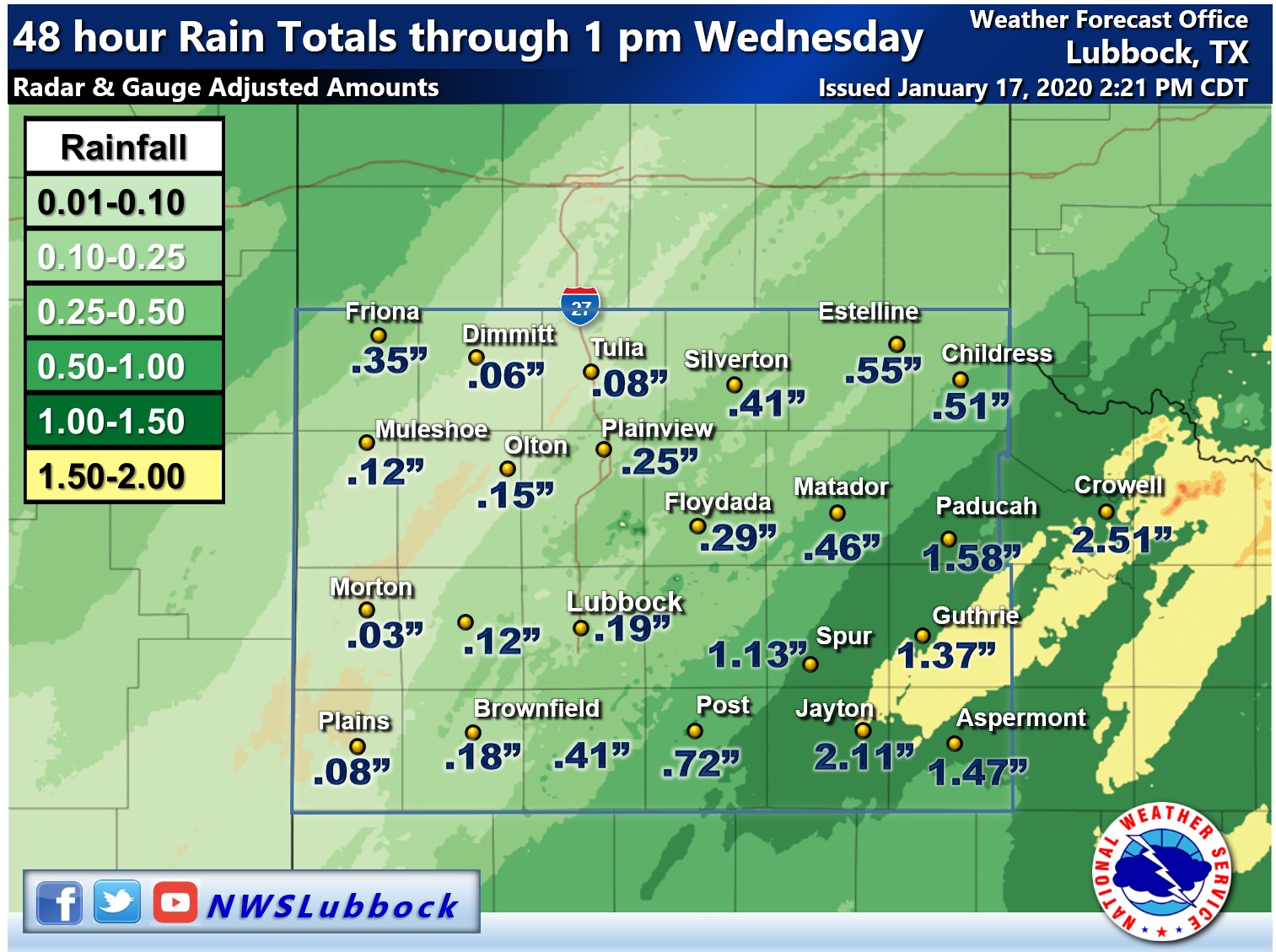
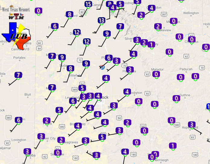
| Radar-estimated and bias-correct liquid equivalent (inches) from the rain and freezing rain on 16-17 January 2020. Several measured West Texas Mesonet rain totals are also displayed. | |||||||||||
| Once melted, rain totals of 1 to 2+ inches were common across much of the Rolling Plains. Lighter totals, from 1/10 to 1/3 inch, were more widespread on the Caprock. Officially, Lubbock measured 0.19" of liquid from this two-day event and Childress tallied 0.42". | |||||||||||
 |
|||||||||||
| Wind barbs and wind speeds observed by the West Texas Mesonet at 5:45 am on 17 January 2019. | |||||||||||
|
The above plot of winds from the West Texas Mesonet early on the 17th clearly illustrates where the heaviest ice had accumulated in the Rolling Plains. The thicker ice coating/glazing caused the anemometers to freeze up, thus reporting wind speeds of zero. Where the icing wasn't as significant, the anemometers continued to function properly and report the wind on the Caprock. Below are the 24-hour highs, lows and precipitation, as reported by the Lubbock COOP Observers from around the region. |
Daily Temperature and Precipitation Summary
National Weather Service Lubbock TX
939 AM CST Fri Jan 17 2020

 The following data are for the previous 24 HRS (8AM - 8AM)
 Highs typically from the previous day.  Low can be either day.

                                                        7-8AM
                      24 HOUR  TODAY   24HR       SNOW  SNOW
  LOCATION            HI  LOW  7-8AM   PCPN       FALL  DEPTH
 Aspermont            39   31   33     1.21        0.0   0
 Big Spring AWOS      44   32   35     0.00        0.0   0
 Brownfield           36   30   33     0.24        0.0   0
 Childress            35   29   32     0.34        0.0   0
 Childress ASOS       38   30   32     0.42        0.0   0
 Crosbyton            36   29   33     0.30        0.0   0
 Denver City           M    M    M        M          M   M
 Dimmitt               M    M    M        M          M   M
 Floydada             35   27   31     0.12        0.0   0
 Friona               31   27   31     0.21        0.0   0
 Guthrie              37   31   34     1.25        0.0   0
 Hart                 33   27   30     0.04        0.0   0
 Jayton                M    M    M        M          M   M
 Lake Alan Henry      39   31   35     1.19        0.0   0
 Levelland            35   30   32     0.11          T   0
 Littlefield 5SE      36   29   32     0.04          T   0
 Lubbock              35   30   34     0.17        0.0   0
 Matador              36   29   32     0.36        0.0   0
 Memphis              37   28   29        M        0.0   0
 Morton               42   29   31     0.05        0.0   0
 Muleshoe             32   27   30     0.03        0.0   0
 Muleshoe Refuge      33   28   31     0.10        0.0   0
 Olton                36   29   32     0.04        0.0   0
 Paducah 15S (Grow)   35   30   32        M        0.0   0
 Plainview Wtr Plnt   36   28   31     0.20        0.0   0
 Plainview Dly Hrld   36   28   32     0.17        0.0   0
 Plains               35   30   32     0.07        0.0   0
 Post                 37   30   33     0.75        0.0   0
 Silverton            32   26   31     0.17        0.0   0
 Snyder               41   30   33     1.13        0.0   0
 Spur                 38   31   32     1.20        0.0   0
 Tahoka               37   30   32     0.34        0.0   0
 Tulia                35   27   30     0.09        0.0   0
 Turkey               36   30   32     0.40        0.0   0
 White River Lake     39   31   33     0.95        0.0   0

  Automated Stations                   High Low  7AM    Rain
 Muleshoe Wildlife Refuge                34  29   33    0.00
 Caprock Canyons State Park RAWS         36  29   32    0.21
 Jayton RAWS                             38  32    M       M

 The following mesonet data show 24hr highs and lows
 and precipitation 8am-8am.

 Texas Tech West Texas Mesonet...
                      24-HR   8AM   8AM-8AM
                      HI LOW
 Abernathy 5NE        36  29   32     0.18
 Aiken 3WSW           37  28   32     0.19
 Adrian 6WSW          33  26   33     0.00
 Amarillo 7SSE        31  25   31     0.00
 Amarillo 9NNE        32  25   32     0.00
 Amarillo 15NNW       32  26   32     0.08
 Amherst 1NE          34  29   32     0.00
 Andrews 2NE          40  32   34     0.58
 Anton 6S             35  30   32     0.11
 Aspermont 3NE        37  31   34     1.37
 BBNP Persimmon Gap   57  42   43     0.34
 BBNP Castolon 1NW    72  48   49     0.21
 Big Lake 1WNW        44  34   40     0.87
 Bootleg 11WNW        32  26   32     0.00
 Boys Ranch 1WSW      33  29   32     0.19
 Brownfield 2S        36  31   34     0.16
 Canadian 6E          29  23   29     0.00
 Caprock Canyons      35  28   31     0.23
 Childress 2NNE       35  28   31     0.09
 Clarendon 2WSW       36  27   29     0.03
 Claude 12SW          33  26   30     0.03
 Clyde  2WNW          39  31   34     1.25
 Colorado City 5NW    41  32   35     0.68
 Coyanosa             46  37   38     0.45
 Crane 1NNW           44  36   38     0.54
 Crowell 1E           36  31   33     2.30
 Dell City 1N         48  32   33     0.10
 Denver City 7W       37  31   33     0.06
 Dimmitt 2NE          31  26   31     0.00
 Dora NM 2SW          33  29   33     0.00
 Dozier 2W            36  27   30     0.14
 Earth 9WSW           33  28   32     0.01
 Endee NM 2SW         35  27   34     0.06
 Estelline 3SSE       37  29   32     0.28
 Floydada 2NE         36  29   33     0.15
 Fluvanna 3W          38  30   32     1.35
 Fort Chadborne       41  33   36     1.04
 Fort Lancaster       50  39   40     0.94
 Fort Lewis CO        39  29   29     0.00
 Fort McKavett        47  35   37     1.23
 Friona 2NE           31  28   31     0.00
 Fritch 1WNW          32  25   32     0.03
 Gail 2SE             40  32   34     1.10
 Goodlett 3W          34  30   31     0.77
 Goodnight            35  27   29     0.01
 Graham 5SW           38  31   33     0.69
 Guadalupe N.P.       52  31   52     0.11
 Guthrie 10W          37  31   32     1.24
 Hackberry 2SSE       36  30   32     0.93
 Happy 1E             33  27   31     0.00
 Hart 3N              34  28   31     0.01
 Haskell 1NW          37  31   35     1.41
 Hefner 1SW           36  31   35     1.86
 Hereford 2NW         31  27   31     0.01
 Hobbs NM 5NW         38  32   34     0.10
 Jayton 1S            37  31   32     2.06
 Junction 1SSW        49  38   39     0.60
 Kent 9E              43  35   39     0.15
 Knox City 3NW        38  31   35     2.01
 Lake Alan Henry 1NW  38  31   33     1.36
 Lake McClellan 2NW   33  25   29     0.01
 Lamesa 2SE           39  31   34     0.59
 Lesley 2S            38  30   31     0.33
 Levelland 4S         34  30   33     0.10
 Lomax 1SSE           42  33   35     0.87
 Lubbock (TX Tech)    36  30   33     0.16
 Lubbock (Reese Ctr)  35  30   33     0.29
 McLean 1E            32  24   29     0.00
 Memphis 1NE          37  30   31     0.49
 Menard 2NWE          47  36   37     0.90
 Mertzon 3NNE         45  34   37     0.37
 Morton 1NE           35  30   33     0.03
 Muleshoe 2S          33  29   32     0.03
 New Home             36  30   34     0.19
 Northfield 1S        37  30   32     0.35
 O`Donnell 1N         38  31   34     0.44
 Olton 6S             36  29   31     0.01
 Odell 4ENE           35  30   33     1.45
 Paducah 10SW         36  30   32     1.32
 Paloduro 4E JA Ranch 38  29   30     0.04
 Palo Duro Canyon Rim 34  26   31     0.00
 Palo Duro Cnyn Floor 37  29   33     0.02
 Palo Duro Reservoir  30  20   30     0.03
 Pampa 2E             30  23   29     0.00
 Panhandle 1SSW       31  24   30     0.03
 Plains 3N            35  30   33     0.07
 Plainview 1S         36  29   32     0.11
 Post 1NE             39  31   35     0.71
 Ralls 1SE            36  29   33     0.07
 Roaring Springs 3N   36  29   32     0.04
 Rotan 5W             39  31   35     0.88
 San Angelo 7NW       45  34   37     0.72
 Seagraves 1SW        37  31   34     0.16
 Segovia 7SSW         49  37   38     0.51
 Seminole 2N          38  32   34     0.13
 Seymour 3NW          37  31   36     2.76
 Sierra Blanca 1SSE   46  36   37     0.00
 Silverton 7E         33  27   31     0.16
 Slaton 2NE           36  30   33     0.10
 Smyer                34  30   33     0.35
 Snyder 3E            38  30   32     1.16
 Snyder 3SSW (WTC)    39  31   34     1.27
 South Plains 3ENE    35  28   32     0.11
 Spur 1W              38  31   33     1.13
 Stamford 5ESE        39  32   35     1.85
 Stinnett 1NNW        30  24   30     0.00
 St Lawrence 5SW      43  33   37     0.62
 Sterling City 4WNW   42  32   36     0.58
 Sundown 8SW          35  31   33     0.07
 Sweetwater 11SW      38  30   38     0.59
 Tahoka 3NE           36  30   33     0.33
 Tarzan 2WNW          42  32   35     0.67
 Tatum NM 2SW         35  30   33     0.03
 Throckmorton 1SW     38  32   35     1.46
 Truscott 2SE         37  31   33     2.53
 Tulia 2NE            36  28   32     0.01
 Turkey 2WSW          36  29   31     0.34
 Umbarger 3NNE        31  26   31     0.01
 Van Horn 3ENE        45  38   40     0.00
 Vigo Park            35  27   32     0.02
 Wall 1E              45  35   38     0.63
 Weinert 2NNE         37  31   35     1.92
 Welch                37  31   34     0.47
 White River Lk 6NW   37  30   32     0.65
 Wolfforth 6SW        36  30   33     0.17

Supplemental Precipitation..
 Childress USDA (Childress Cnty)     0.44        0.0   0
 Childress 14NW (Childress Cnty)        M          M   M
 Childress 7NW  (Childress Cnty)        M          M   M
 Dodson 5S      (Childress Cnty)        M          M   M
 Kirkland 1W    (Childress Cnty)        M          M   M
 Dumont         (NW King County)        M          M   M
 Floydada 9SE     (Floyd County)     0.50        0.0   0
 Flomot 2E    (NW Motley County)     0.16        0.0   0
 Flomot 4NE   (NW Motley County)        M          M   M
 Lubbock 9N     (Lubbock County)        M          M   M
 Lubbock 7WSW (77TH NR Iola)            M          M   M
 Lubbock 7SW  (90TH NR Slide)        0.16        0.0   0
 Lubbock 7SW #2 (103RD NR Slide)        M          M   M
 Northfield   (NE Motley County)        M          M   M
 Paducah 10S     (Cottle County)     1.12        0.0   0
 Pitchfork Ranch     (E Dickens)        M          M   M
 Reese 4E   (8th ST & Milwaukee)        M          M   M
 Roaring Springs (Motley County)        M          M   M
 Ropesville 6NNW(Hockley County)     0.20        0.0   0
 Shallowater    (Lubbock County)        M          M   M
 Tell 3S        (Childress Cnty)     0.26        0.0   0
 Woodrow 3W  (154th & Indiana)       0.23        0.0   0

  ..Automated USGS Rain Gauges..
 Aspermont 13N (Stonewall County)    1.78
 Brice 6SW        (Hall County)      0.11
 Childress 10N(Childress County)     0.17
 Friona 12S  Running Water Dr        0.00
 Justiceburg(Garza County)           0.00
 Kirkland 1NNE N Grosebeck Ck        0.26
 Lake Alan Henry (Garza County)      1.08
 Lockney 10SW  Callahan Draw         0.01
 Lubbock 4ESE (50TH LOOP 289)        0.15
 Mackenzie Lake (Briscoe County)     0.00
 Silverton 7W Rock Ck Tr                M
 Wellman 1NE (Terry County)          0.30
 White River Lake (Crosby County)    0.75
 Wayside (Armstrong County)          0.00

 ------------- Agricultural Data -----------------
                                      Pan Evaporation
 Lake Alan Henry                               0.04

