
Scattered thunderstorms with severe gusts, hail and a tornado risk are possible near a cold front from the Ohio Valley to the Mid-Atlantic tonight. Tropical Storm Bertha is expected to bring tropical storm conditions to portions of the Gulf Coast from the panhandle of Florida into Louisiana through Wednesday. Read More >
|
T-storms generate large hail, damaging winds, flooding rain and tornadoes |
|||||
 |
|||||
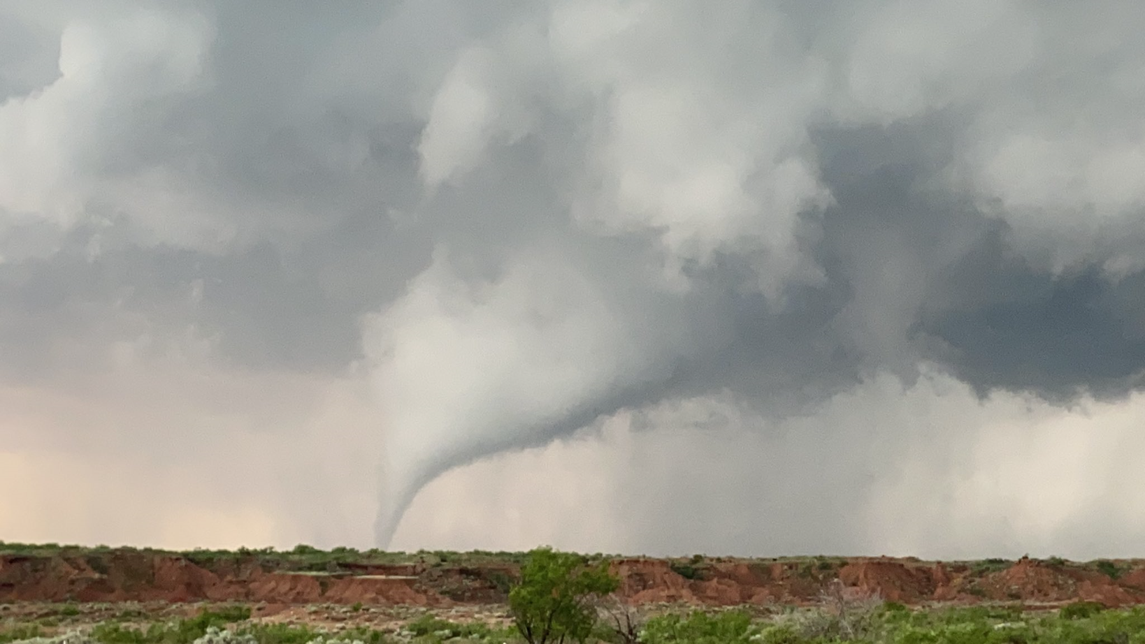
| Tornado captured south of Post Saturday evening (23 May 2020). The image is courtesy of Josh Moore. | |||||
|
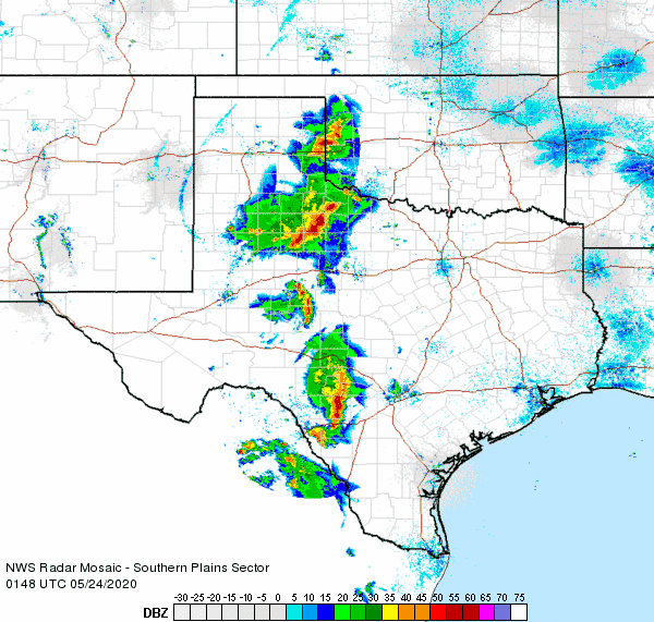
Moisture surged westward onto the Caprock Friday night, setting the stage for an active Saturday afternoon and evening (23 May). As temperatures climbed into the 90s, scattered thunderstorms erupted across the South Plains region. Many of the storms produced small hail, and when they rotated the hail grew larger. |
|||||
 |
|||||
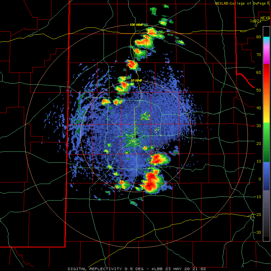
| Lubbock radar animation valid from 4:02 PM to 5:39 PM on 23 May 2020. | |||||
| One particularly intense storm developed over southwestern Garza County, where it became anchored for a few hours. In addition to dropping large hail and torrential rain, this storm generated at least a couple of tornadoes (see the picture at the top of this page). Fortunately, the tornadoes remained over rural areas and did no known damage. | |||||
 |
|||||
| Large hail that fell in Silverton Saturday evening (23 May 2020). The picture is courtesy of Ian Shelton. | |||||
|
|||||
 |
|||||
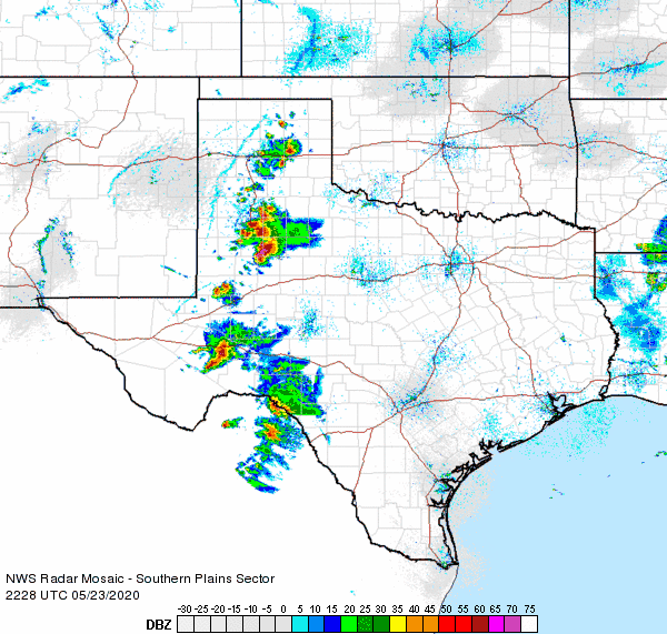
| Regional radar animation valid from 5:28 pm to 6:38 pm on 23 May 2020. Additional regional radar animations can be viewed at: 3:58 pm to 5:08 pm; 4:48 pm to 5:58 pm; and 8:48 pm to 9:58 pm on 23 May 2020. | |||||
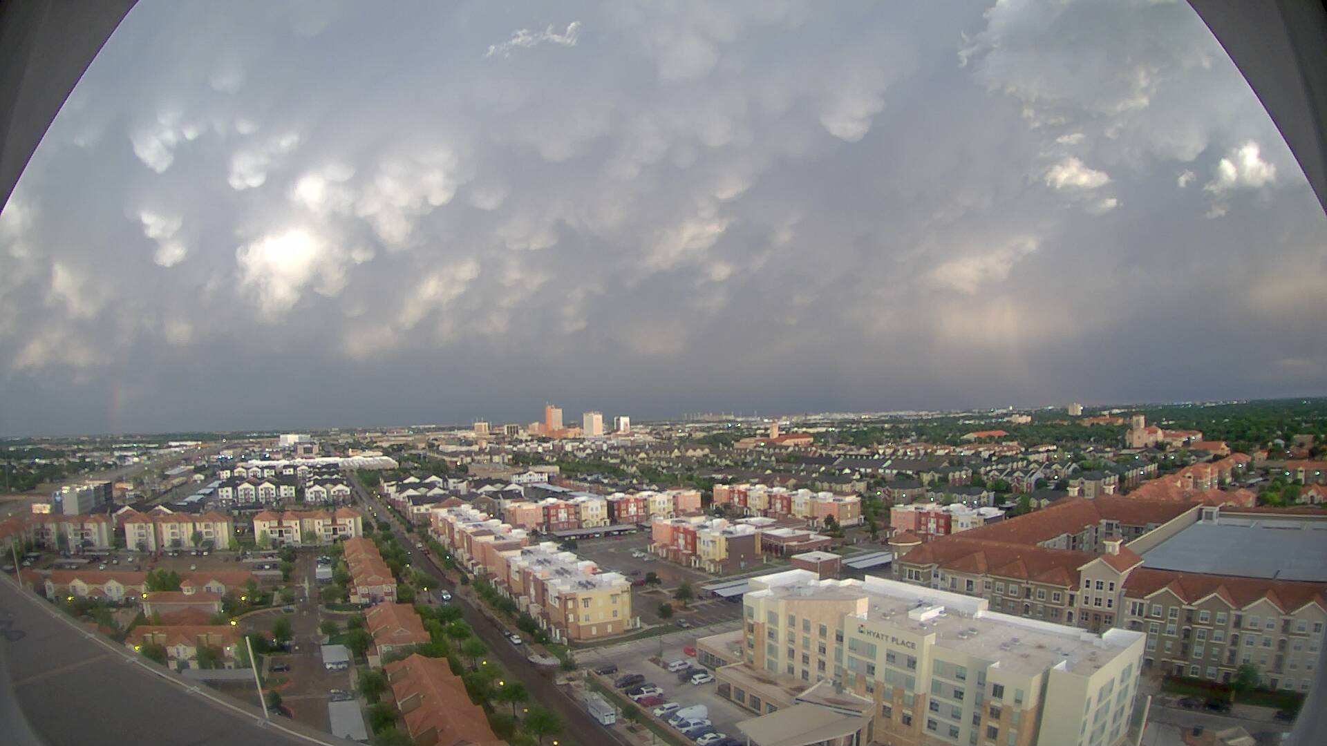
| The storms eventually grew into a complex that spread eastward across the Rolling Plains Saturday evening. Strong to severe wind gusts, small hail and heavy rain accompanied the complex. As the system shifted eastward, the setting sun illuminated the back side of the complex, creating a vividly picturesque sky. | |||||
 |
|||||
| Looking east from Overton, in Lubbock, Saturday evening (23 May 2020). The image is courtesy of KAMC. | |||||
|
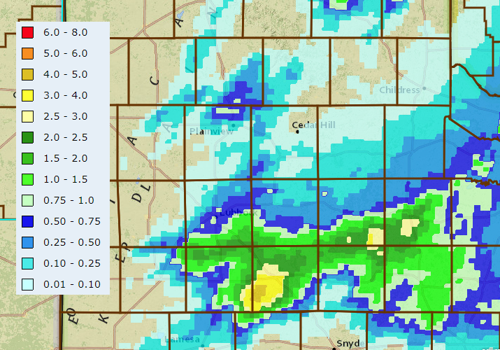
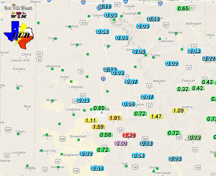
Where the most intense storm of the day lingered, several inches of rain fell over much of the southwest half of Garza County. Rain totals of 3 to 5+ inches fell in a couple of hours. The West Texas Mesonet site in Post measured 3.42 inches, while southwest of town, the Graham site recorded a whopping 6.60 inches. |
|||||
 |
|||||
| 24-hour radar-estimated and bias-corrected rain totals ending at 9 AM on Sunday (24 May). Rain totals measured by the West Texas Mesonet over this same time can be VIEWED HERE. | |||||
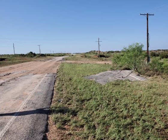
| Runoff from the torrential rainfall created flash flooding as water poured off the Caprock and funneled into the Double Mountain Fork of the Brazos River. The flood waters swept the pavement off FM 669 south of Post, as seen below. | |||||
 |
|||||
| Portion of FM 669 washed out south of Post on 24 May 2020. The picture is courtesy of John Lipe. | |||||
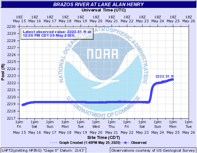
| The suddenly water-infused upper Brazos River poured into Lake Alan Henry, quickly raising the lake level over three feet. This propelled the lake above the conservation level for the first time since 2016. | |||||
 |
|||||
| Level of Lake Alan Henry in mid-late May 2020. | |||||
| The preliminary wind and storm reports from this active May 23rd can be viewed below. | |||||
PRELIMINARY LOCAL STORM REPORT...SUMMARY
NATIONAL WEATHER SERVICE LUBBOCK TX
1127 PM CDT SAT MAY 23 2020

..TIME...   ...EVENT...      ...CITY LOCATION...     ...LAT.LON...
..DATE...   ....MAG....      ..COUNTY LOCATION..ST.. ...SOURCE....
            ..REMARKS..

0437 PM     FUNNEL CLOUD     12 ESE DRAW             32.97N 101.47W
05/23/2020                   GARZA              TX   SOCIAL MEDIA

            SOCIAL MEDIA REPORT/PICTURE OF A FUNNEL CLOUD ON THE
            BORDEN AND GARZA COUNTY LINE.

0448 PM     HAIL             1 W SOUTHLAND           33.36N 101.56W
05/23/2020  M1.00 INCH       LYNN               TX   PUBLIC

            MPING REPORT.

0505 PM     HAIL             BUFFALO SPRINGS         33.53N 101.71W
05/23/2020  M1.00 INCH       LUBBOCK            TX   TRAINED SPOTTER

0506 PM     TSTM WND GST     8 S LUBBOCK             33.46N 101.88W
05/23/2020  M62 MPH          LUBBOCK            TX   BROADCAST MEDIA

            GUST MEASURED AT KCBD STUDIO

0514 PM     TORNADO          S POST                  33.19N 101.38W
05/23/2020                   GARZA              TX   SOCIAL MEDIA

0515 PM     TORNADO          9 ESE DRAW              32.99N 101.51W
05/23/2020                   GARZA              TX   TRAINED SPOTTER

0518 PM     TSTM WND GST     6 NNE LUBBOCK           33.67N 101.82W
05/23/2020  M61 MPH          LUBBOCK            TX   ASOS

0519 PM     HAIL             1 WNW SLATON            33.45N 101.66W
05/23/2020  E1.75 INCH       LUBBOCK            TX   PUBLIC

            MPING REPORT.

0525 PM     TORNADO          S POST                  33.19N 101.38W
05/23/2020                   GARZA              TX   SOCIAL MEDIA

0525 PM     TSTM WND GST     5 SSW GRAHAM            33.08N 101.52W
05/23/2020  M59 MPH          GARZA              TX   MESONET

0531 PM     HAIL             6 NNE LUBBOCK           33.67N 101.82W
05/23/2020  M1.00 INCH       LUBBOCK            TX   ASOS

0534 PM     HAIL             5 SW LUBBOCK            33.52N 101.95W
05/23/2020  M1.00 INCH       LUBBOCK            TX   NWS EMPLOYEE

0535 PM     HAIL             4 E WOLFFORTH           33.51N 101.95W
05/23/2020  M1.50 INCH       LUBBOCK            TX   NWS EMPLOYEE

0541 PM     HAIL             3 ENE WOLFFORTH         33.52N 101.97W
05/23/2020  M1.50 INCH       LUBBOCK            TX   NWS EMPLOYEE

0542 PM     TSTM WND GST     3 WSW AIKEN             34.13N 101.57W
05/23/2020  M60 MPH          HALE               TX   MESONET

            ALSO A GUST TO 59 MPH MEASURED AT 546 PM.

0542 PM     HAIL             WOODROW                 33.45N 101.84W
05/23/2020  M2.00 INCH       LUBBOCK            TX   SOCIAL MEDIA

0548 PM     HAIL             1 SSW WEST END PLACE    33.56N 101.96W
05/23/2020  E1.75 INCH       LUBBOCK            TX   PUBLIC

            MPING REPORT.

0600 PM     TSTM WND DMG     3 N O`DONNELL           33.01N 101.83W
05/23/2020                   LYNN               TX   TRAINED SPOTTER

            ENCLOSED TRAILER TOWED BY VEHICLE TIPPED OVER ON
            HIGHWAY 87.

0600 PM     HAIL             WEST END PLACE          33.57N 101.94W
05/23/2020  M1.00 INCH       LUBBOCK            TX   SOCIAL MEDIA

0601 PM     HAIL             1 NE LUBBOCK SOUTH PLAI 33.55N 101.91W
05/23/2020  M1.25 INCH       LUBBOCK            TX   NWS EMPLOYEE

0605 PM     TSTM WND DMG     3 SE LUBBOCK SOUTH PLAI 33.51N 101.89W
05/23/2020                   LUBBOCK            TX   EMERGENCY MNGR

            SEVERAL POLES DOWN NEAR SLATON HIGHWAY AND 98TH AND
            INDIANA.

0622 PM     HAIL             SILVERTON               34.47N 101.30W
05/23/2020  M2.75 INCH       BRISCOE            TX   TRAINED SPOTTER

0622 PM     HAIL             SILVERTON               34.47N 101.30W
05/23/2020  M3.25 INCH       BRISCOE            TX   PUBLIC

            SOCIAL MEDIA REPORT STATED THAT NUMEROUS CAR
            WINDSHILEDS HAD BEEN BROKEN.

0623 PM     HAIL             WOLFFORTH               33.51N 102.01W
05/23/2020  M1.50 INCH       LUBBOCK            TX   SOCIAL MEDIA

0623 PM     HAIL             SILVERTON               34.47N 101.30W
05/23/2020  M3.00 INCH       BRISCOE            TX   SOCIAL MEDIA

0628 PM     HAIL             PLAINVIEW               34.19N 101.72W
05/23/2020  M1.00 INCH       HALE               TX   SOCIAL MEDIA

0637 PM     TSTM WND GST     2 ENE TULIA             34.54N 101.74W
05/23/2020  M60 MPH          SWISHER            TX   MESONET

0730 PM     FLASH FLOOD      8 SSE GRAHAM            33.04N 101.41W
05/23/2020                   GARZA              TX   LAW ENFORCEMENT

            SECTION OF HIGHWAY 669 WAS REPORTED WASHED OUT IN GARZA
            COUNTY DUE TO FLASH FLOODING. TIME ESTIMATED.

0735 PM     NON-TSTM WND GST CAPROCK CANYON SP       34.41N 101.06W
05/23/2020  M58 MPH          BRISCOE            TX   MESONET

0809 PM     FLASH FLOOD      1 SSE POST              33.18N 101.38W
05/23/2020                   GARZA              TX   TRAINED SPOTTER

            RUSHING WATER OVER THE ROAD NEAR POST, TEXAS NEAR
            HIGHWAY 84 WITH VEHICLE STALLED IN ROAD.

0825 PM     TSTM WND GST     1 SSE JAYTON            33.23N 100.57W
05/23/2020  M64 MPH          KENT               TX   MESONET

0835 PM     NON-TSTM WND GST 2 W CHILDRESS           34.43N 100.28W
05/23/2020  M58 MPH          CHILDRESS          TX   ASOS

