
Numerous severe thunderstorms are expected across a broad region from the Ohio Valley to the Mid-Atlantic and Northeast States today into tonight. Swaths of damaging wind gusts are expected and some tornadoes are possible. Bertha is expected to bring tropical storm conditions to portions of the Gulf Coast from the Florida Panhandle westward to southeastern Louisiana later today and Wednesday. Read More >
| Heat fuels intense thunderstorms 4 June 2020 |
|||||||||||
 |
|||||||||||
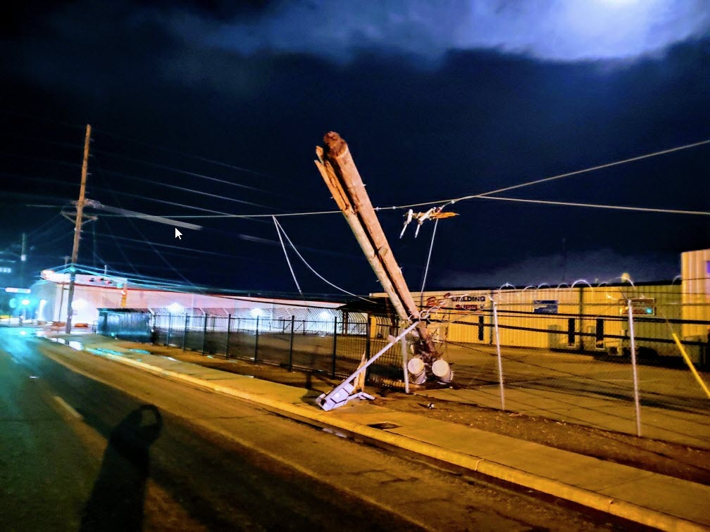
| Downed power pole near 1600 East and 50th Street in Lubbock Thursday evening (4 June 2020). The image is courtesy of Wood Franklin. | |||||||||||
|
Intense heating, coupled with a weak passing mid-level disturbance and sufficient moisture and instability, fueled an active round of weather Thursday afternoon and evening (4 June). Temperatures climbing to near and above the triple digit mark provided enough energy to cause widely scattered thunderstorms to develop across the Texas Panhandle Thursday afternoon. |
|||||||||||
 |
|||||||||||
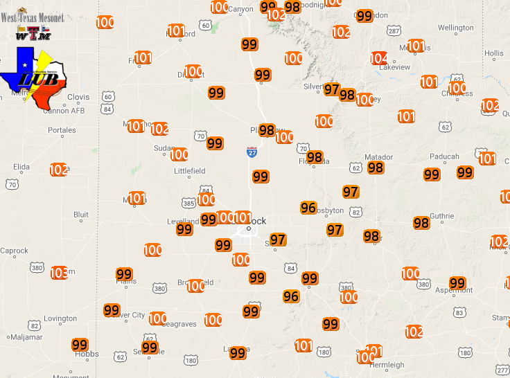
| High temperatures measured by the West Texas Mesonet on Thursday, 4 June 2020. | |||||||||||
| The hot and well mixed lower atmosphere and high-based nature of the thunderstorms provided ideal conditions for the generation of strong and severe wind gusts, though pockets of hail also occurred with the most intense storms. A wind gust of 72 mph was measured from one storm near Silverton, while a 60 mph gust was recorded at Caprock Canyon State Park. | |||||||||||
 |
|||||||||||
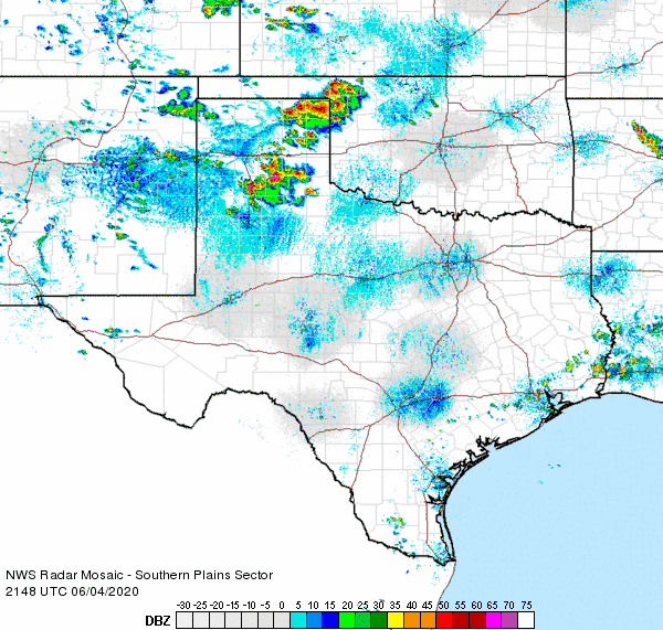
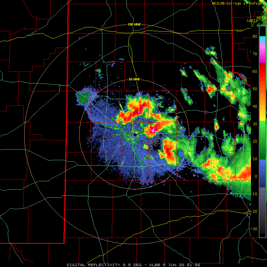
| Regional radar animation valid from 4:48 pm to 5:58 pm on 4 June 2020. Additional regional radar animations can be found at: 2:48 pm to 3:58 pm; 5:48 pm to 6:58 pm; 7:48 pm to 8:58 pm; and 8:18 pm to 9:28 pm. | |||||||||||
| The thunderstorm activity developed and tracked south and southeast through the evening. Accumulating dime size hail fell just east of Plainview, while golf ball size hail was observed west of Floydada, north of Lorenzo and in Ralls. This same storm produced 2 inch diameter hail near the small community of Allmon, southwest of Floydada, while also generating damaging winds that downed multiple power poles, blew over a tractor trailer and flipped a center pivot near Ralls. | |||||||||||
 |
|||||||||||
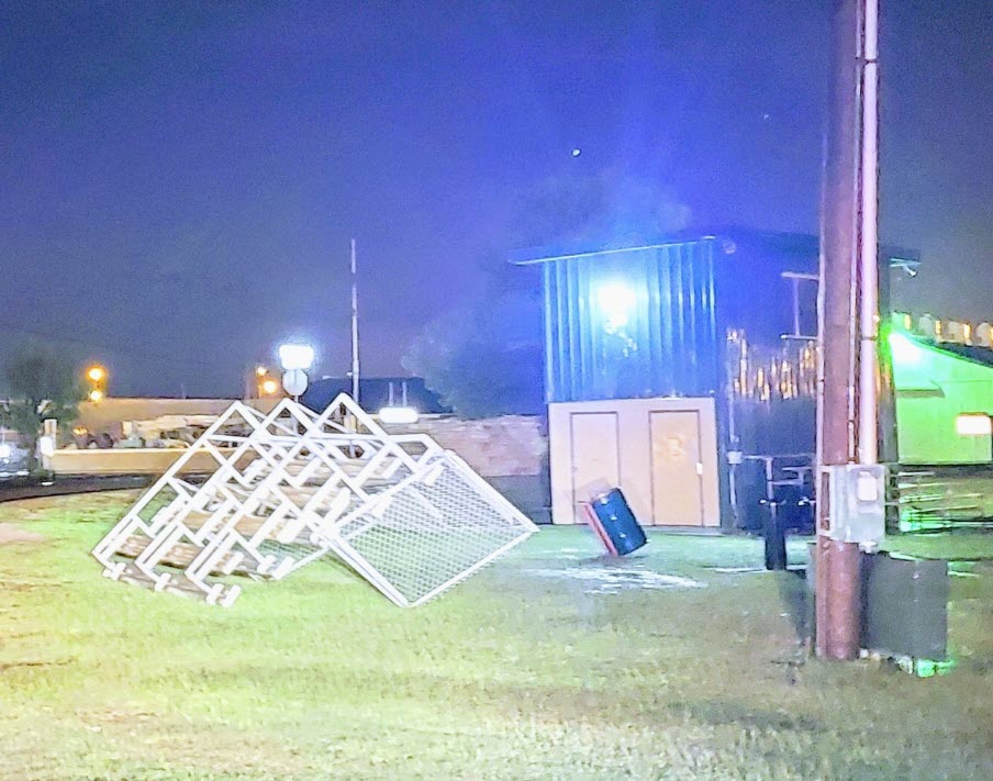
| Flipped softball stands at Mackenzie Park in northeast Lubbock Thursday evening (4 June 2020). The image is courtesy of Wood Franklin. | |||||||||||
|
|||||||||||
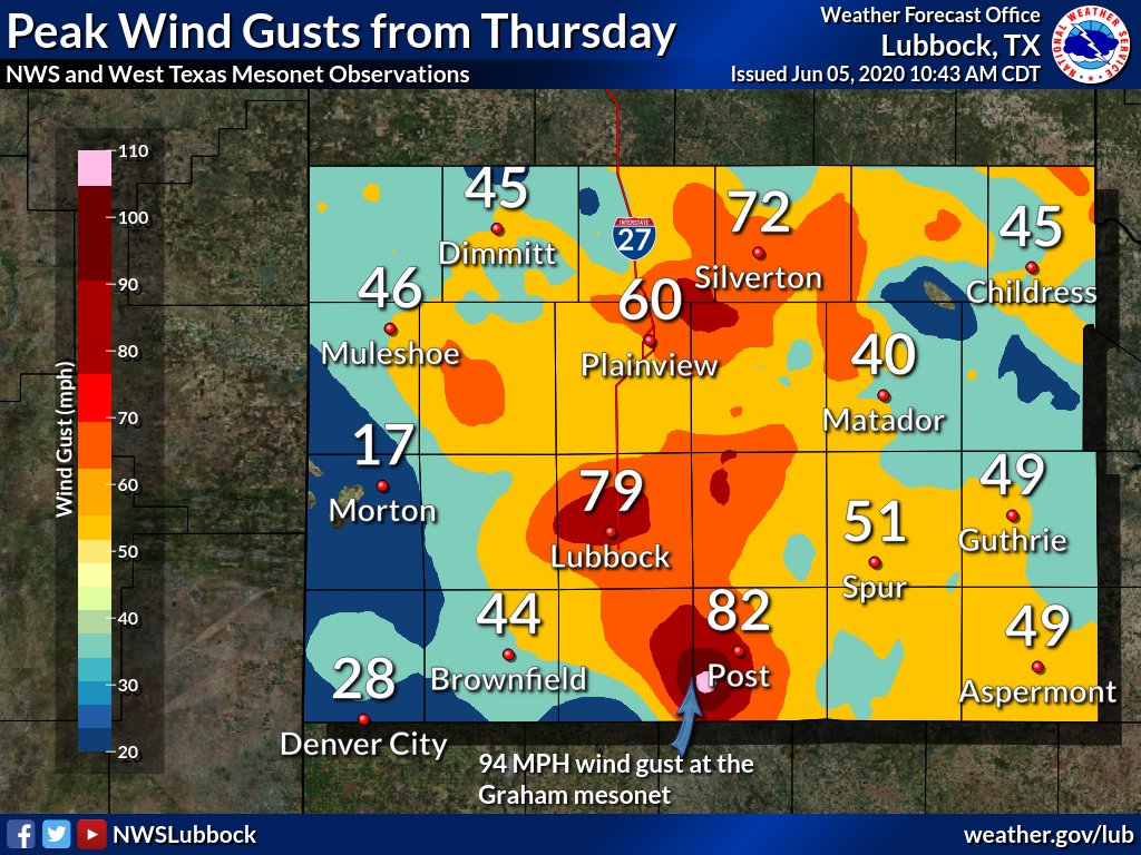
| The thunderstorms formed into a small cluster as they raced southward across the southeast South Plains and far western Rolling Plains through the late evening hours. Wind gusts in excess of 70 mph accompanied this activity, with a gust as high as 94 mph measured in southwest Garza County, along the edge of the Caprock. | |||||||||||
 |
|||||||||||
| Peak thunderstorm wind gusts (mph) measured by the West Texas Mesonet and NWS Thursday evening (4 June 2020). | |||||||||||
| Unfortunately, the powerful winds caused significant damage in and around Post, including flattening outbuildings, lofting carports, damaging roofs, flipping a semi and downing transmission poles. | |||||||||||
 |
|||||||||||
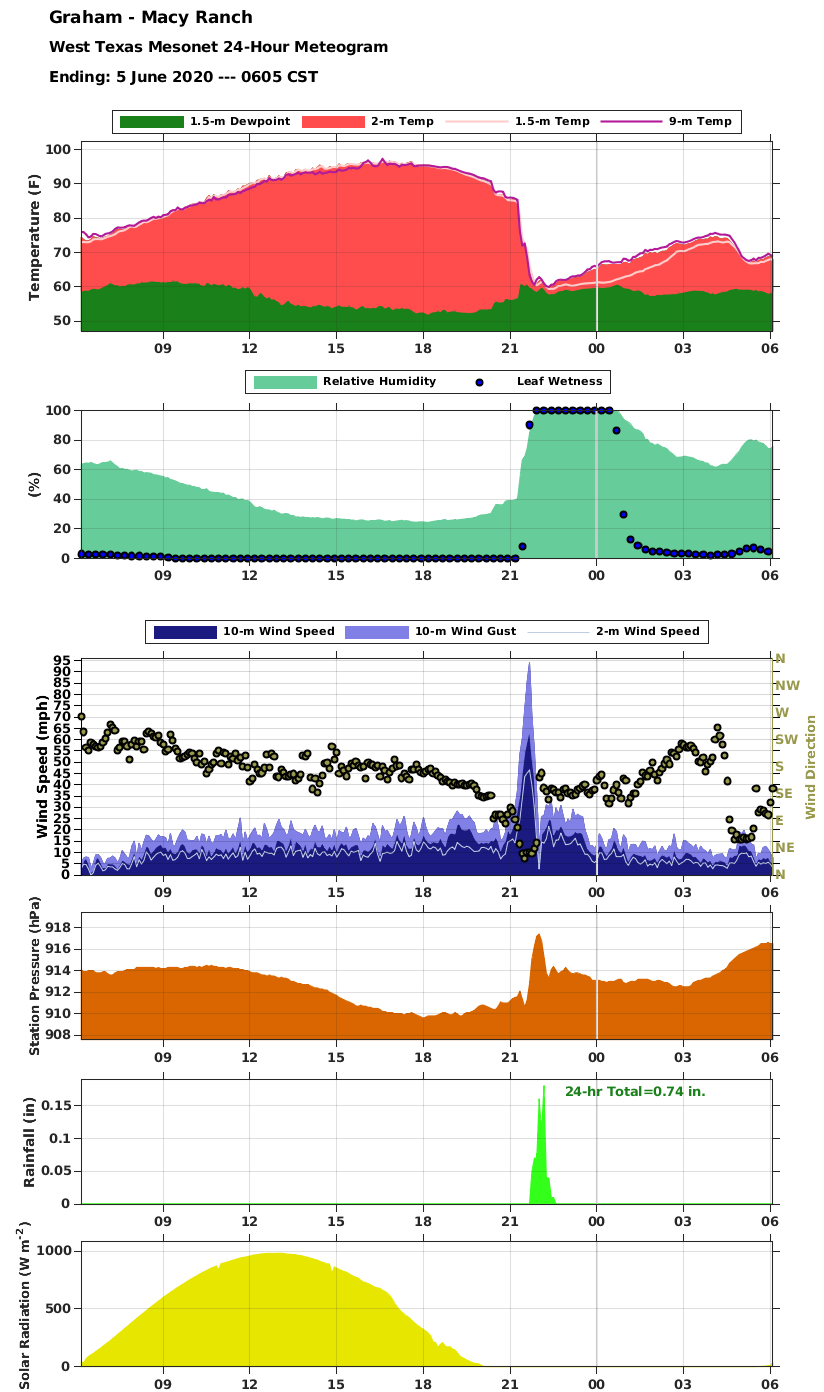
| Meteogram from the Macy Ranch West Texas Mesonet on Thursday (4 June 2020). | |||||||||||
| The above graphs show how various meteorological variable responded as the extreme winds moved through the Macy Ranch West Texas Mesonet site. The temperature plummeted from the upper 80s to near 60 degrees in a matter of minutes. The strongest winds occurred in advance of the rainfall, though a period of heavy rain and relatively high pressure did immediately follow the worst of the wind. | |||||||||||
 |
|||||||||||
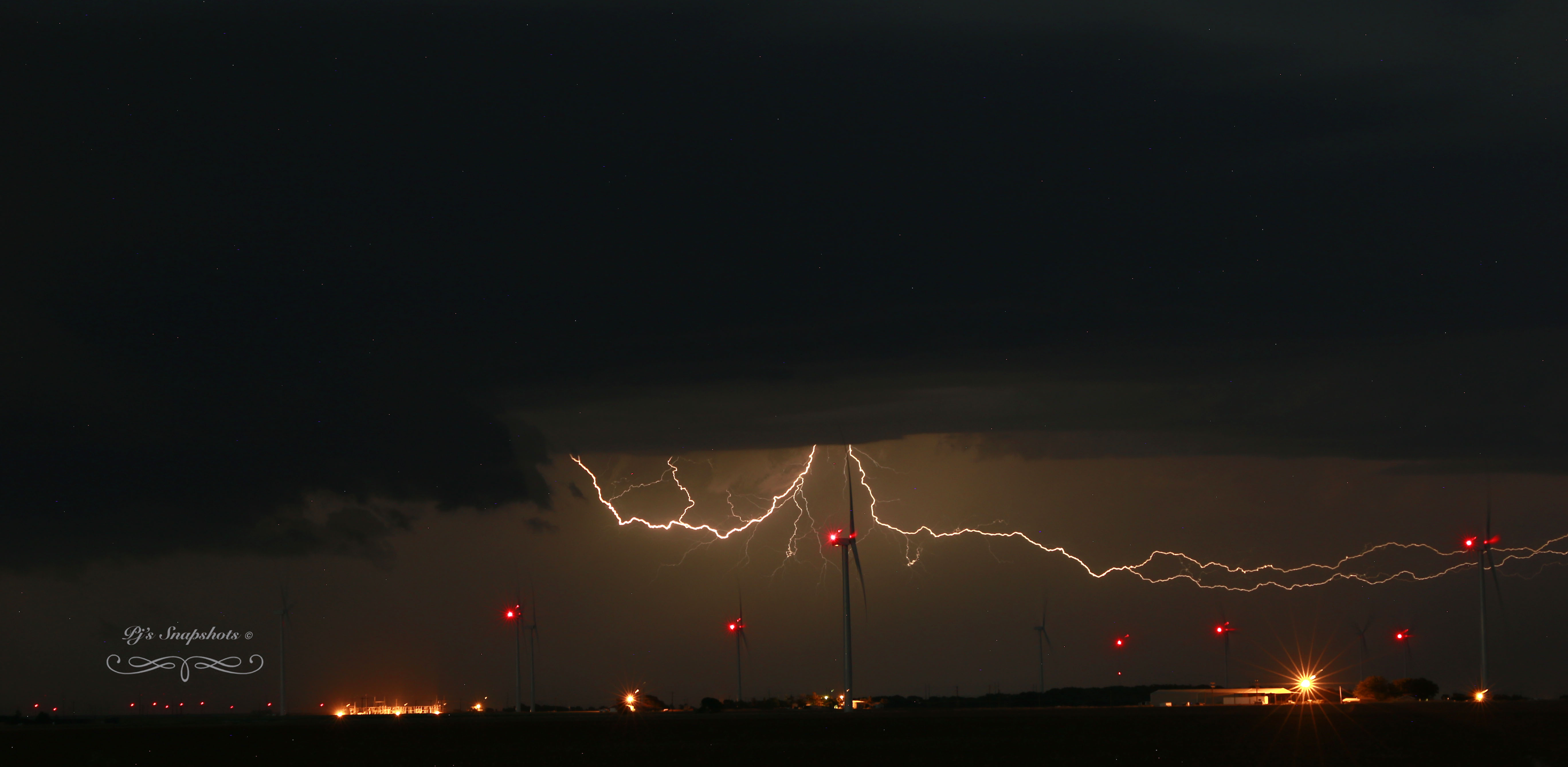
| Nice lightning shot captured by Pam Elrod as storms approached the Tahoka area Thursday evening (4 June 2020). | |||||||||||
|
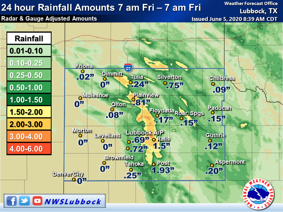
Although the severe outflow winds were the most significant impact at most spots, the thunderstorms did also produce swaths of heavy rain. The heaviest rain, from 1 to 2+ inches, fell in a narrow band from west of Tulia to near Plainview, Ralls and Post. The torrential rain did damage FM 207 north of Post, resulting in its temporary closure. Runoff also poured into Lake Alan Henry, ensuring it remained full, almost 2 feet above conservation level. Officially, Lubbock record 0.69 inches, boosting the yearly total to 6.02 inches. |
|||||||||||
 |
|||||||||||
| 24-hour radar-estimated and bias-adjusted rainfall totals valid at 7 am on 5 June 2020. Also shown are select West Texas Mesonet and NWS measured rain totals. | |||||||||||
| The preliminary storm reports for June 4th can be viewed below. |
PRELIMINARY LOCAL STORM REPORT...SUMMARY
NATIONAL WEATHER SERVICE LUBBOCK TX
1006 AM CDT FRI JUN 05 2020

..TIME...   ...EVENT...      ...CITY LOCATION...     ...LAT.LON...
..DATE...   ....MAG....      ..COUNTY LOCATION..ST.. ...SOURCE....
            ..REMARKS..

0510 PM     TSTM WND GST     7 ESE SILVERTON         34.45N 101.19W
06/04/2020  M72 MPH          BRISCOE            TX   MESONET

            WINDS GUST OF 72 MPH AT SILVERTON MESONET.

0524 PM     TSTM WND GST     CAPROCK CANYON SP       34.41N 101.06W
06/04/2020  M60 MPH          BRISCOE            TX   MESONET

0545 PM     TSTM WND GST     1 S PLAINVIEW           34.18N 101.71W
06/04/2020  M55 MPH          HALE               TX   MESONET

            55 MPH WIND GUST FROM PLAINVIEW MESONET.

0608 PM     HAIL             5 E PLAINVIEW           34.19N 101.64W
06/04/2020  E0.75 INCH       HALE               TX   BROADCAST MEDIA

            ACCUMULATING DIME TO PENNY SIZED HAIL.

0638 PM     TSTM WND GST     2 W CHILDRESS           34.43N 100.28W
06/04/2020  M58 MPH          CHILDRESS          TX   ASOS

0650 PM     HAIL             8 W FLOYDADA            33.98N 101.48W
06/04/2020  E1.75 INCH       FLOYD              TX   SOCIAL MEDIA

0700 PM     HAIL             7 N LORENZO             33.77N 101.53W
06/04/2020  M1.75 INCH       CROSBY             TX   BROADCAST MEDIA

0728 PM     HAIL             1 NNE ALLMON            33.90N 101.50W
06/04/2020  E2.00 INCH       FLOYD              TX   SOCIAL MEDIA

0730 PM     TSTM WND DMG     RALLS                   33.68N 101.38W
06/04/2020                   CROSBY             TX   FIRE DEPT/RESCUE

            FIRE / RESCUE CALLED AND ADVISED MULTIPLE POWERPOLES
            BLOWN DOWN AND A TRACTOR TRAILER BLOWN OVER.

0730 PM     TSTM WND DMG     RALLS                   33.68N 101.38W
06/04/2020                   CROSBY             TX   SOCIAL MEDIA

            CENTER PIVOT FLIPPED NEAR RALLS. LOCATION AND TIME
            ESTIMATED.

0735 PM     TSTM WND GST     1 SE RALLS              33.67N 101.38W
06/04/2020  M62 MPH          CROSBY             TX   MESONET

0745 PM     HAIL             RALLS                   33.68N 101.38W
06/04/2020  M1.75 INCH       CROSBY             TX   FIRE DEPT/RESCUE

            TIME FROM RADAR

0825 PM     NON-TSTM WND GST 1 NE AMHERST            34.02N 102.40W
06/04/2020  M58 MPH          LAMB               TX   MESONET

0835 PM     TSTM WND DMG     7 NW CAPROCK            33.55N 101.50W
06/04/2020                   CROSBY             TX   PUBLIC

            ROOF DAMAGED

0850 PM     DUST STORM       ABERNATHY               33.83N 101.84W
06/04/2020                   HALE               TX   SOCIAL MEDIA

            LOW VISIBILITY IN BLOWING DUST NEAR ABERNATHY OBSERVED
            IN POST ON SNAPCHAT. TIME ESTIMATED FROM RADAR.

0920 PM     TSTM WND GST     6 NNE LUBBOCK           33.67N 101.82W
06/04/2020  M77 MPH          LUBBOCK            TX   ASOS

0927 PM     TSTM WND GST     REESE CENTER            33.61N 102.05W
06/04/2020  M69 MPH          LUBBOCK            TX   MESONET

0930 PM     TSTM WND GST     3 WNW LUBBOCK           33.60N 101.90W
06/04/2020  M72 MPH          LUBBOCK            TX   MESONET

0935 PM     TSTM WND DMG     LUBBOCK                 33.58N 101.88W
06/04/2020                   LUBBOCK            TX   LAW ENFORCEMENT

            MULTIPLE POWERPOLES DOWN IN THE CITY OF LUBBOCK.

0938 PM     TSTM WND GST     7 SW LUBBOCK            33.50N 101.96W
06/04/2020  E50 MPH          LUBBOCK            TX   NWS EMPLOYEE

0938 PM     TSTM WND GST     3 NW WOODROW            33.47N 101.89W
06/04/2020  E60 MPH          LUBBOCK            TX   NWS EMPLOYEE

0938 PM     TSTM WND GST     7 SSW LUBBOCK           33.49N 101.87W
06/04/2020  E50 MPH          LUBBOCK            TX   NWS EMPLOYEE

0938 PM     HAIL             7 SSW LUBBOCK           33.49N 101.87W
06/04/2020  M0.75 INCH       LUBBOCK            TX   NWS EMPLOYEE

0940 PM     TSTM WND GST     2 NE SLATON             33.46N 101.62W
06/04/2020  M60 MPH          LUBBOCK            TX   MESONET

0950 PM     TSTM WND DMG     1 S SOUTHLAND           33.35N 101.55W
06/04/2020                   GARZA              TX   UTILITY COMPANY

            3 TRANSMISSION POLES DOWN. TIME OF DAMAGE ESTIMATED
            FROM RADAR AND NEARBY OBSERVATIONS.

1000 PM     TSTM WND DMG     6 W POST                33.19N 101.49W
06/04/2020                   GARZA              TX   UTILITY COMPANY

            TRANSMISSION POLES DOWN. TIME ESTIMATED FROM RADAR AND
            NEARBY OBSERVATIONS.

1004 PM     TSTM WND GST     3 NNE TAHOKA            33.21N 101.78W
06/04/2020  M60 MPH          LYNN               TX   MESONET

1010 PM     TSTM WND GST     1 NE POST               33.20N 101.37W
06/04/2020  M67 MPH          GARZA              TX   MESONET

1015 PM     TSTM WND DMG     POST                    33.19N 101.38W
06/04/2020                   GARZA              TX   LAW ENFORCEMENT

            NUMEROUS REPORTS OF WIND DAMAGE IN POST, INCLUDING
            OUTBUILDING FLATTENED, CARPORTS LOFTED, ROOFS DAMAGED
            AND A SEMI FLIPPED. TIME OF DAMAGE ESTIMATED FROM RADAR
            AND NEARBY OBSERVATIONS.

1020 PM     TSTM WND GST     1 NE POST               33.20N 101.37W
06/04/2020  M73 MPH          GARZA              TX   MESONET

1030 PM     TSTM WND GST     5 SSW GRAHAM            33.08N 101.52W
06/04/2020  M73 MPH          GARZA              TX   MESONET

1035 PM     TSTM WND GST     5 SSW GRAHAM            33.08N 101.52W
06/04/2020  M85 MPH          GARZA              TX   MESONET

1040 PM     TSTM WND GST     5 SSW GRAHAM            33.08N 101.52W
06/04/2020  M94 MPH          GARZA              TX   MESONET

            MEASURED BY THE WEST TEXAS MESONET

