
Tropical Storm Bertha could bring tropical storm conditions to portions of the Florida Panhandle and Alabama coast through Wednesday, where a Tropical Storm Watch and Storm Surge Watch is in effect. Numerous severe thunderstorms with heavy rainfall are expected from the Ohio Valley into the Mid-Atlantic and Northeast Tuesday. Read More >
|
Powerful winter storm brings widespread snow to West Texas |
|||
 |
|||
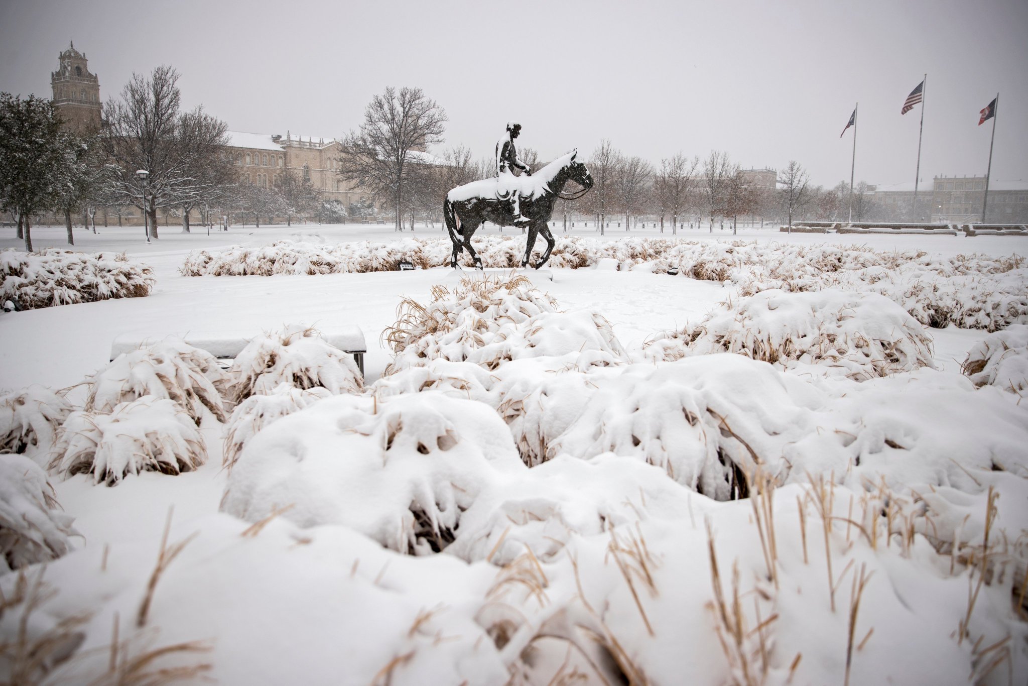
| Snow covering Texas Tech on Sunday (10 January 2021). The picture is courtesy of Brad Tollerfson. | |||
|
The first winter storm of 2021 affected the South Plains region during the weekend of January 9th and 10th. The system brought widespread snowfall to the South Plains, Rolling Plains and southern Texas Panhandle. The storm system responsible for the widespread wintry precipitation dropped southeastward through the Intermountain west before turning more eastward as it emerged over New Mexico late on Saturday, the 9th. |
|||
 |
|||
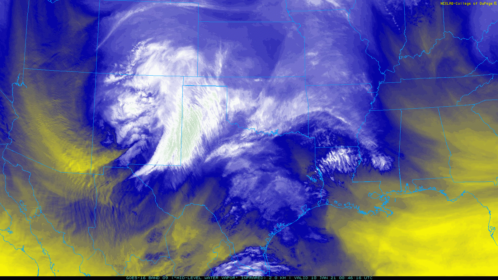
| Mid-level water vapor loop captured from GOES-16 on Saturday evening (9 January 2021) shows a large storm system approaching through New Mexico. The animation is valid from 6:46 pm to 7:31 pm CST. | |||
| Well in advance of the upper level storm system, chilly, cloudy, drizzle and damp conditions prevailed over the South Plains on Saturday. Areas of freezing fog and freezing drizzle occurred through Saturday evening, creating spotty slick spots. Then, as lift from the system overspread the region, a heavier wintry mix quickly changed over to snow late Saturday evening/night. | |||
 |
|||
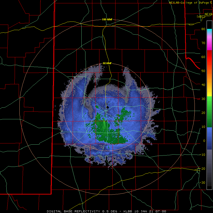
| Lubbock radar animation valid from 1:00 am to 8:28 am on Sunday (10 January 2021). | |||
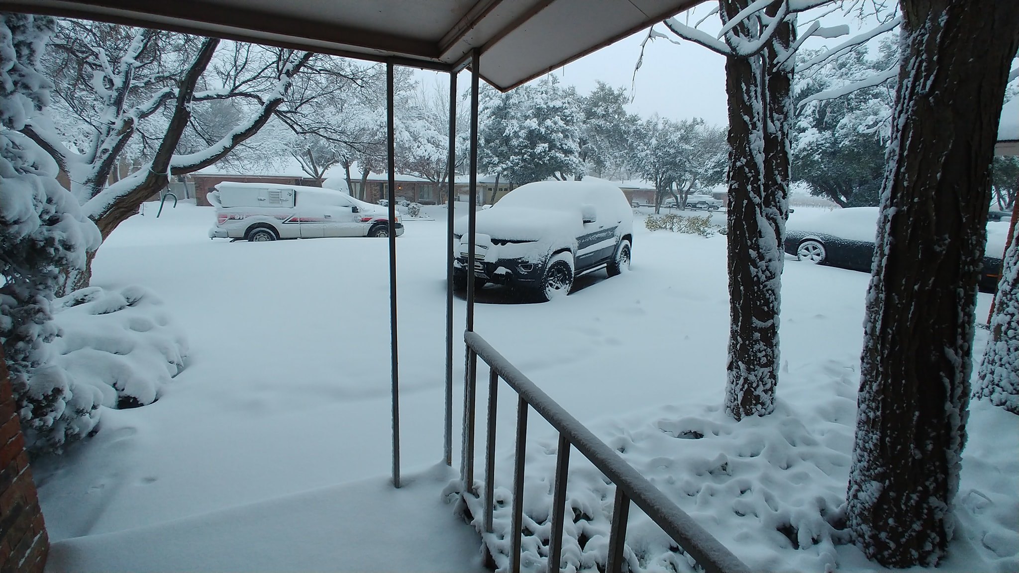
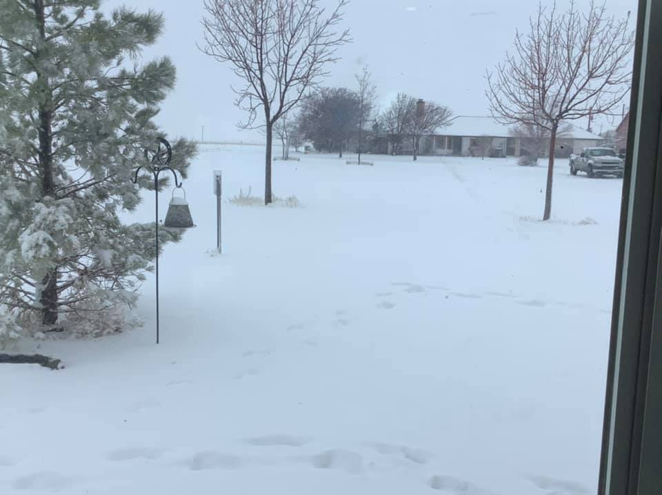
| Steady snow, heavy at times, affected most of the South Plains from late Saturday night into Sunday morning, with light snow lingering over much of the region through Sunday afternoon before diminishing. Many people woke up to a wintry scene Sunday morning. Along with the persistent light snow, temperatures were stuck in the 20s and 30s on Sunday, though thankfully winds were on the light side. | |||
 |
|||
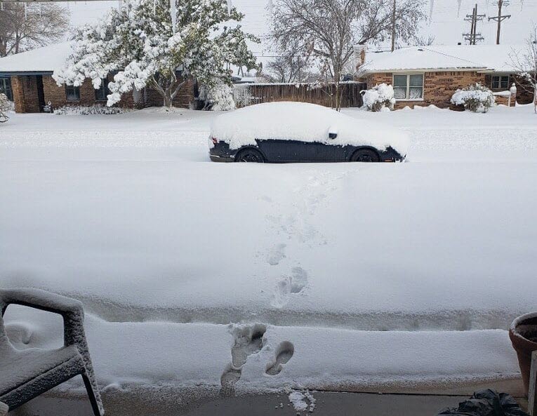
| Heavy snow blanketing Brownfield Sunday morning (10 January 2021). The picture is courtesy of David Drummond. | |||
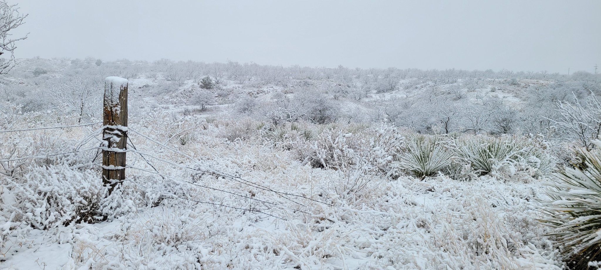
| The heavy wet snow created beautiful scenes, though the snow-covered roadways did make for hazardous travel. The sticky snow was also great for making snow balls and snowman, though it was not as fun to shovel due to its weight. | |||
|
|
|||
 |
|||
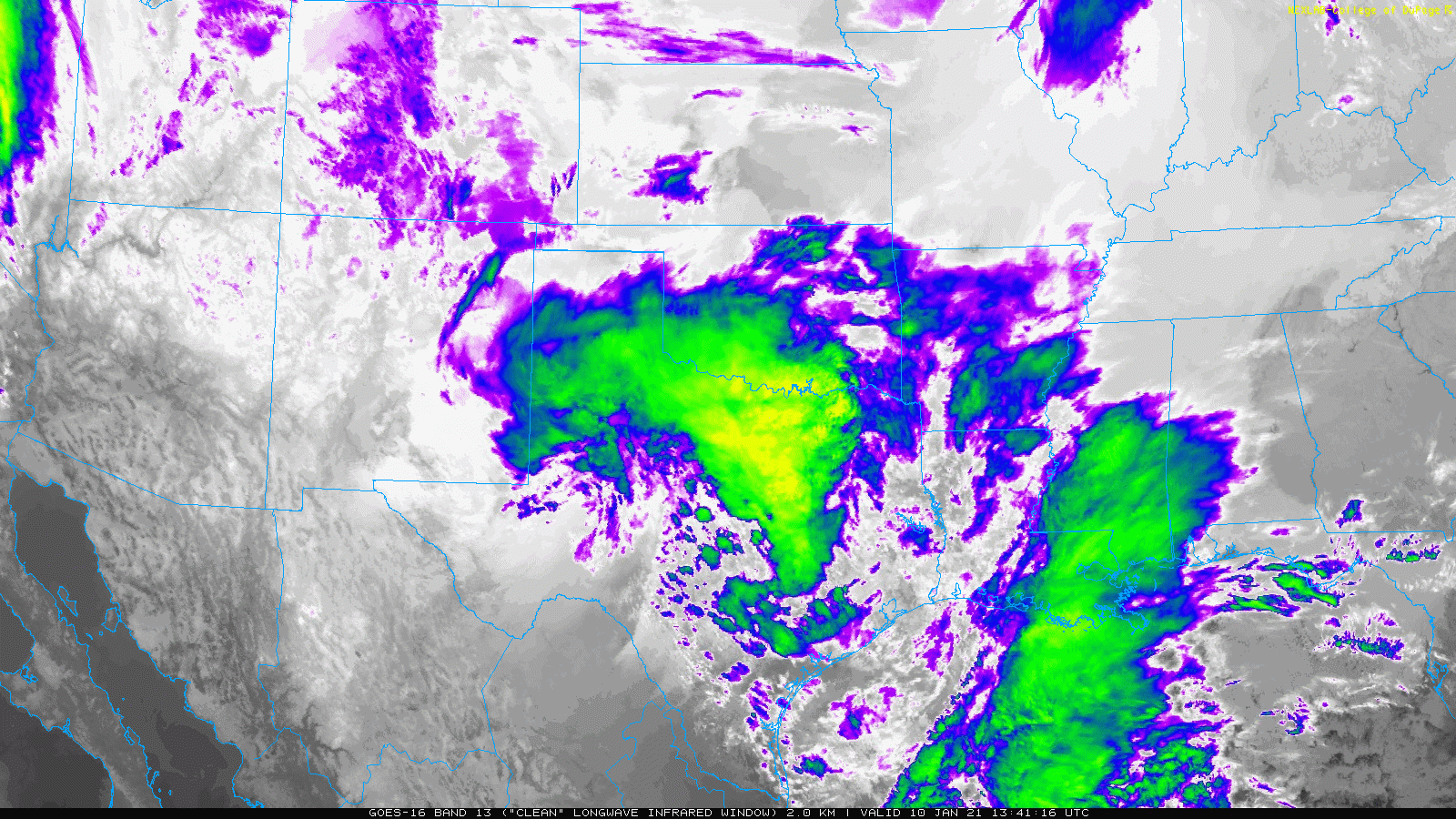
| Infrared satellite loop captured from GOES-16 on Sunday (10 January 2021). The animation is valid from 7:41 am to 8:26 am CST. | |||
| Even as the center of the storm system shifted to the east, plenty of lower to mid-level moisture did get wrapped westward into West Texas through Sunday afternoon. This kept clouds and periods of light snow in place. | |||
|
|||
| A blanket of snow near Estelline, TX, on Sunday (10 January 2021). The picture is courtesy of Farrah Holcomb. | |||
|
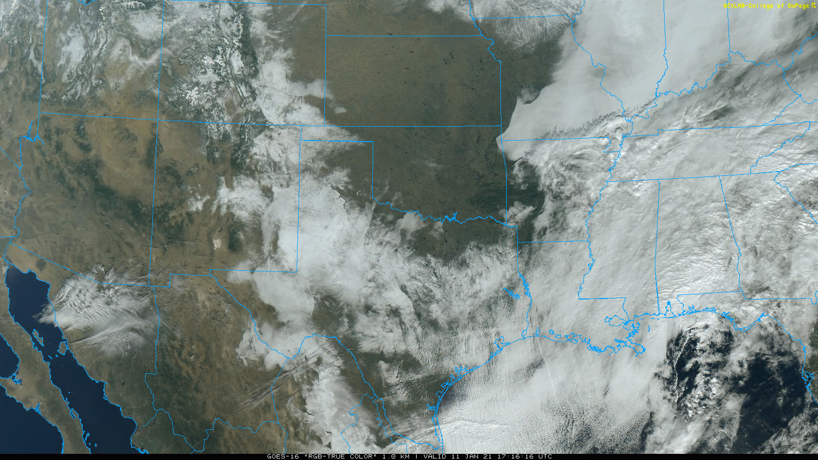
The following day, Monday (11 January), skies became mostly clear. This allowed us to see the extent of the snow cover from satellite (below). A large swath of snow can be seen from the southeast Colorado plains into eastern New Mexico and much of the South Plains and northern Permian Basin, then eastward into the central part of Texas. Although clouds obscured the view of the ground (and snow) further south and east, Austin and College Station into East Texas and northern Louisiana and northern and central Mississippi also recorded significant snowfall. |
|||
 |
|||
| "True color" satellite loop captured from GOES-16 on Monday (11 January 2021). The animation is valid from 11:16 am to 12:01 pm CST. | |||
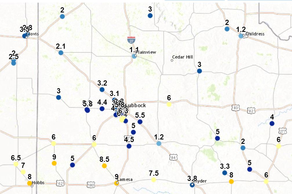
| The big snowfall winner was Denver City where they measured 11 inches. Many other locations from the central and southern South Plains into the northern Permian Basin measured between 6 and 8 inches. Officially, the Lubbock Airport record 7.6 inches of snow on the 10th, breaking the previous daily snowfall record of 4.5 inches (set in 1936). | |||
 |
 |
||
| Heavy snow in Denver City (left) and near Littlefield (right) on Sunday (10 January 2021). The pictures are courtesy of our COOP observers Clinton Bowman and Vadarae Gohlke. | |||
| Further north, across the southern Texas Panhandle, northern South Plains and northern and central Rolling Plains, snow totals were lighter, generally in the 1 to 3-inch range. | |||
 |
|||
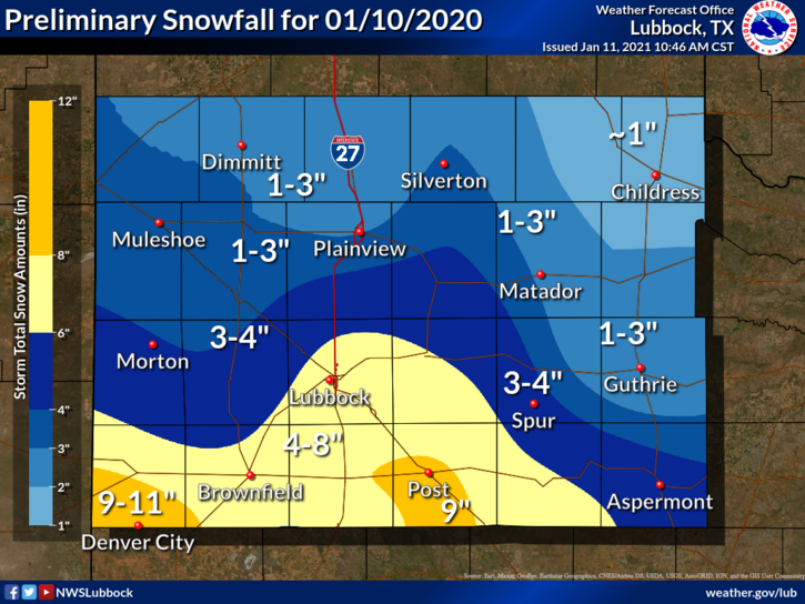
| Graphic displaying the approximate snowfall that fell on Sunday (10 January 2021). Actual snow reports collected by the National Weather Service can be SEEN HERE. A plot of statewide snowfall for this event can be ACCESSED HERE. | |||
|
The heavy wet snow did bring much-need beneficial moisture to the region. Officially, Lubbock recorded 0.68 inches of liquid (melted snow) from this event, the most since late October of 2020. Liquid equivalent totals generally ranged from around a 1/4 to 1/3 of an inch across the southern Texas Panhandle to 1/2 to 3/4 of an inch over the southern South and Rolling Plains. A plot of the melted snow totals from the West Texas Mesonet can be VIEWED HERE. The preliminary snow reports collected during this event can be found below. |
|||
PRELIMINARY LOCAL STORM REPORT...SUMMARY
NATIONAL WEATHER SERVICE LUBBOCK TX
1240 PM CST MON JAN 11 2021

..TIME...   ...EVENT...      ...CITY LOCATION...     ...LAT.LON...
..DATE...   ....MAG....      ..COUNTY LOCATION..ST.. ...SOURCE....
            ..REMARKS..

0800 AM     SNOW             2 NE WEST END PLACE     33.60N 101.93W
01/10/2021  E2.8 INCH        LUBBOCK            TX   SOCIAL MEDIA

            AVERAGED SNOWFALL WITH A RANGE FROM 1.5"-3.7" NEAR
            NORTH SLIDE AND AUBURN.

0830 AM     HEAVY SNOW       3 WNW WOODROW           33.46N 101.89W
01/10/2021  M6.1 INCH        LUBBOCK            TX   NWS EMPLOYEE

0830 AM     HEAVY SNOW       3 ENE WOLFFORTH         33.52N 101.97W
01/10/2021  M4.5 INCH        LUBBOCK            TX   NWS EMPLOYEE

0830 AM     HEAVY SNOW       WOODROW                 33.45N 101.84W
01/10/2021  M4.0 INCH        LUBBOCK            TX   SOCIAL MEDIA

0830 AM     SNOW             MATADOR                 34.02N 100.82W
01/10/2021  M3.0 INCH        MOTLEY             TX   CO-OP OBSERVER

0835 AM     HEAVY SNOW       1 S LEVELLAND           33.57N 102.36W
01/10/2021  E5.8 INCH        HOCKLEY            TX   PUBLIC

            GRASSY SURFACES HAD 5.5"-6".

0850 AM     HEAVY SNOW       SLATON                  33.44N 101.64W
01/10/2021  M5.5 INCH        LUBBOCK            TX   SOCIAL MEDIA

0857 AM     SNOW             SHALLOWATER             33.69N 101.99W
01/10/2021  M3.1 INCH        LUBBOCK            TX   NWS EMPLOYEE

0920 AM     HEAVY SNOW       4 ESE LUBBOCK SOUTH PLA 33.51N 101.86W
01/10/2021  E4.8 INCH        LUBBOCK            TX   BROADCAST MEDIA

            NEAR 93RD AND AVE V.

0925 AM     SNOW             ANTON                   33.81N 102.16W
01/10/2021  M3.2 INCH        HOCKLEY            TX   PUBLIC

0945 AM     HEAVY SNOW       1 SE DENVER CITY        32.96N 102.82W
01/10/2021  E9.0 INCH        YOAKUM             TX   CO-OP OBSERVER

0945 AM     HEAVY SNOW       CROSBYTON               33.64N 101.24W
01/10/2021  M6.0 INCH        CROSBY             TX   CO-OP OBSERVER

            STILL SNOWING.

0953 AM     SNOW             VIGO PARK               34.65N 101.50W
01/10/2021  E3.0 INCH        SWISHER            TX   CO-OP OBSERVER

1010 AM     SNOW             SMYER                   33.59N 102.16W
01/10/2021  M4.4 INCH        HOCKLEY            TX   SOCIAL MEDIA

1114 AM     SNOW             3 S ESTELLINE           34.50N 100.44W
01/10/2021  E2.0 INCH        HALL               TX   EMERGENCY MNGR

            LIGHT SNOW STILL FALLING.

1130 AM     HEAVY SNOW       JAYTON                  33.25N 100.57W
01/10/2021  M5.0 INCH        KENT               TX   CO-OP OBSERVER

1200 PM     HEAVY SNOW       4 SSW LUBBOCK           33.53N 101.88W
01/10/2021  M5.8 INCH        LUBBOCK            TX   NWS OFFICE

            LIGHT SNOW STILL FALLING.

1220 PM     HEAVY SNOW       1 NE DOUD               33.56N 101.92W
01/10/2021  M5.8 INCH        LUBBOCK            TX   SOCIAL MEDIA

            NEAR 34TH AND SLIDE.

1230 PM     SNOW             SHALLOWATER             33.69N 101.99W
01/10/2021  M3.9 INCH        LUBBOCK            TX   NWS EMPLOYEE

            STORM TOTAL SNOW

1234 PM     HEAVY SNOW       LEVELLAND               33.58N 102.37W
01/10/2021  M5.3 INCH        HOCKLEY            TX   SOCIAL MEDIA

            STORM TOTAL SNOWFALL NEAR SOUTH PLAINS COLLEGE.

0117 PM     HEAVY SNOW       7 SSW LUBBOCK           33.49N 101.87W
01/10/2021  M6.3 INCH        LUBBOCK            TX   NWS EMPLOYEE

            STORM TOTAL SNOW.

0350 PM     SNOW             FLOYDADA                33.98N 101.34W
01/10/2021  M5.0 INCH        FLOYD              TX   CO-OP OBSERVER

            STORM TOTAL SNOW

0400 PM     SNOW             ASPERMONT               33.14N 100.22W
01/10/2021  M5.0 INCH        STONEWALL          TX   CO-OP OBSERVER

            STORM TOTAL SNOW

0400 PM     SNOW             BROWNFIELD              33.18N 102.27W
01/10/2021  M7.0 INCH        TERRY              TX   CO-OP OBSERVER

            STORM TOTAL SNOW

0400 PM     SNOW             DENVER CITY             32.97N 102.83W
01/10/2021  M11.0 INCH       YOAKUM             TX   CO-OP OBSERVER

            STORM TOTAL SNOW

0400 PM     SNOW             CROSBYTON               33.64N 101.24W
01/10/2021  M7.0 INCH        CROSBY             TX   CO-OP OBSERVER

            STORM TOTAL SNOW

0400 PM     SNOW             MULESHOE                34.23N 102.73W
01/10/2021  M2.5 INCH        BAILEY             TX   CO-OP OBSERVER

            STORM TOTAL SNOW

0400 PM     SNOW             PLAINS                  33.19N 102.83W
01/10/2021  M7.0 INCH        YOAKUM             TX   CO-OP OBSERVER

            STORM TOTAL SNOW

0400 PM     SNOW             SILVERTON               34.47N 101.30W
01/10/2021  M4.0 INCH        BRISCOE            TX   CO-OP OBSERVER

            STORM TOTAL SNOW

0400 PM     SNOW             TURKEY                  34.39N 100.90W
01/10/2021  M5.0 INCH        HALL               TX   CO-OP OBSERVER

            STORM TOTAL SNOW

0400 PM     SNOW             WHITE RIVER LAKE        33.48N 101.10W
01/10/2021  M7.0 INCH        CROSBY             TX   CO-OP OBSERVER

            STORM TOTAL SNOW

0400 PM     SNOW             ROPESVILLE              33.41N 102.15W
01/10/2021  M6.0 INCH        HOCKLEY            TX   CO-OP OBSERVER

            STORM TOTAL SNOW

0400 PM     SNOW             3 W WOODROW             33.45N 101.90W
01/10/2021  M7.0 INCH        LUBBOCK            TX   NWS EMPLOYEE

            STORM TOTAL SNOW

0410 PM     SNOW             MATADOR                 34.02N 100.82W
01/10/2021  M5.0 INCH        MOTLEY             TX   CO-OP OBSERVER

            STORM TOTAL SNOW

0430 PM     SNOW             6 NNE LUBBOCK           33.67N 101.82W
01/10/2021  M7.6 INCH        LUBBOCK            TX   WX OBSERVER FAA

            STORM TOTAL SNOW

0430 PM     SNOW             TAHOKA                  33.16N 101.79W
01/10/2021  M8.0 INCH        LYNN               TX   CO-OP OBSERVER

            STORM TOTAL SNOW

0500 PM     SNOW             TELL                    34.38N 100.39W
01/10/2021  M1.5 INCH        CHILDRESS          TX   CO-OP OBSERVER

            STORM TOTAL SNOW

