
Dangerous heat will expand from the Gulf Coast into the Southern Plains and Desert Southwest through week's end. Additional extreme heat impacting the Pacific Northwest will shift to the northern Plains by the weekend. Tropical Storm Bertha is expected to continue to impact portions of the northern Gulf Coast from the western Florida Panhandle to southeastern Louisiana through tonight. Read More >
|
Thunderstorms bring welcome widespread rain, along with wind and hail |
|||
 |
|||
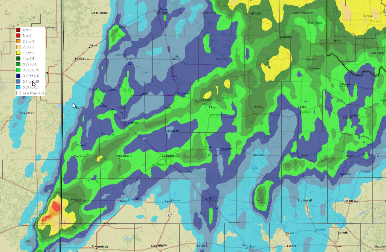
| 24-hour radar-estimated and bias-correct rainfall ending at 6 am on 11 May 2022. Rain totals measured by the West Texas Mesonet can be FOUND HERE. | |||
|
Tuesday afternoon and evening (10 May 2022) saw the first widespread significant rainfall on the South Plains region this year. The precipitation came with numerous severe wind gusts and pockets of hail, as is common for May on the southern High Plains. The thunderstorms that provided the much-needed rain were triggered along/near a dryline, with the help of strong daytime heating and a weak upper level disturbance ejecting northward out of Mexico. |
|||
 |
|||
|
|||
|
The initial activity rapidly developed near the dryline, which was located near the Texas/New Mexico line, late Tuesday afternoon. Aided by strong instability, several of the storms quickly became severe, producing pockets of hail and fairly widespread severe-caliber winds, in addition to the rare rainfall. Wind gusts near and in excess of 60 mph were first measured by the West Texas Mesonet around Morton, Amherst (where 1" diameter hail was also observed) and Dimmitt. |
|||
 |
|||
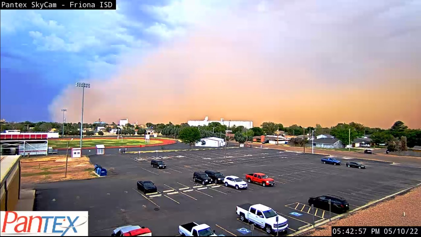
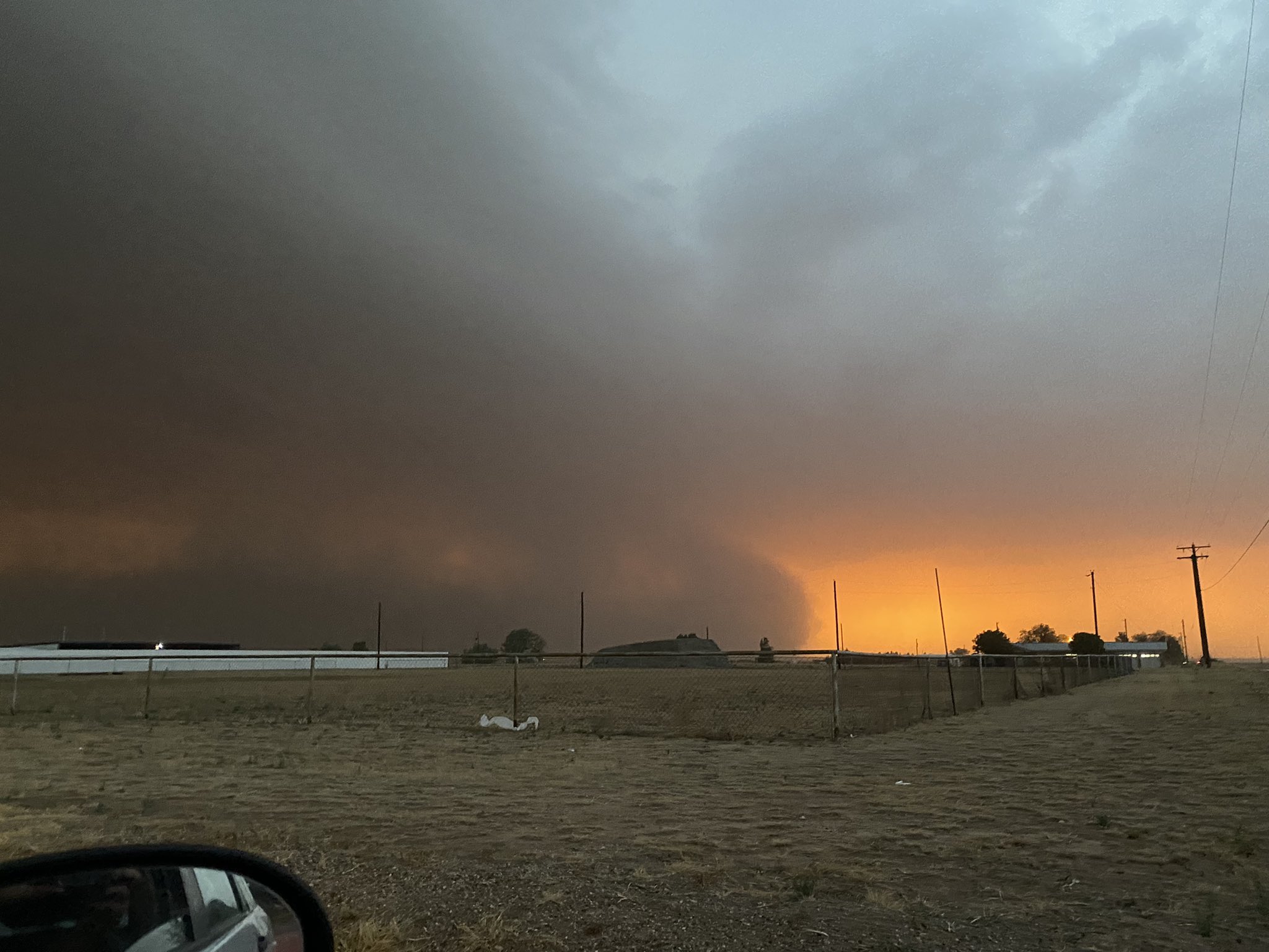
| Wall of dust (haboob) moving through Friona Tuesday evening (10 May 2022). The image is courtesy of Pantex. | |||
|
The intense winds lofted copious amounts of dust, and produced several haboobs (walls of dust) that marched across the region, including the one above shown about to overrun Friona. |
|||
 |
|||
| 1-minute visible satellite loop valid from 6:35 pm to 6:41 pm on Tuesday (10 May 2022). Note the shadows associated with numerous overshooting tops (very tall tops of the most intense thunderstorms). | |||
|
The thunderstorms gradually evolved into a solid line and tracked eastward across much of the South Plains, Rolling Plains and southern Texas Panhandle through the mid-late evening hours. This rare occurrence (for 2022), brought plenty of wind and rain, along with a few pockets of mostly small hail. |
|||
 |
|||
| Regional radar animation valid from 8:40 pm to 9:35 pm on 10 May 2022. | |||
|
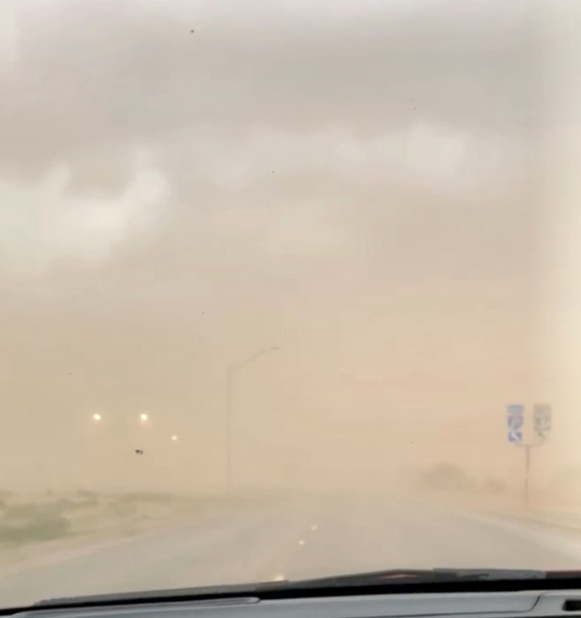
Below are a couple images of the dirt/dust that was kicked up by the strong outflow winds, often well in advance of the rain and parent thunderstorm. |
|||
 |
 |
||
| A wall of dust (haboob) near Smyer (left) and what it looked like inside a haboob near Plainview (right) Tuesday evening (10 May 2022). The left picture is courtesy of Jack Maney, and the right image is courtesy of Missy Zavala via Chad Casey. | |||
| As the line of storms moved eastward, they merged with another cluster of activity advancing northward over the Rolling Plains. This further enhanced the rainfall over the southeast Texas Panhandle and northwestern Rolling Plains. | |||
 |
|||
|
Lubbock WSR-88D radar animation valid from 8:18 pm to 9:43 pm on 10 May 2022. Additional radar animations can be viewed at: 3:09 pm to 9:43 pm on 10 May; and 7:03 pm on 10 May to 7:12 am on 11 May. |
|||
| The showers and thunderstorms gradually diminished and shifted off into western Oklahoma after midnight, but not before dropping widespread rainfall. Rain totals of 0.50 to 1.50 inches were common from the southwest South Plains through the central and northeast South Plains and into eastern Texas Panhandle. Officially, the Lubbock Airport recorded 0.71 inches of rain, which more than doubled the year-to-date total to 1.29 inches. Even after this rainfall, Lubbock is still 3.12 inches below the average year-to-date total of 4.41 inches. | |||
 |
|||
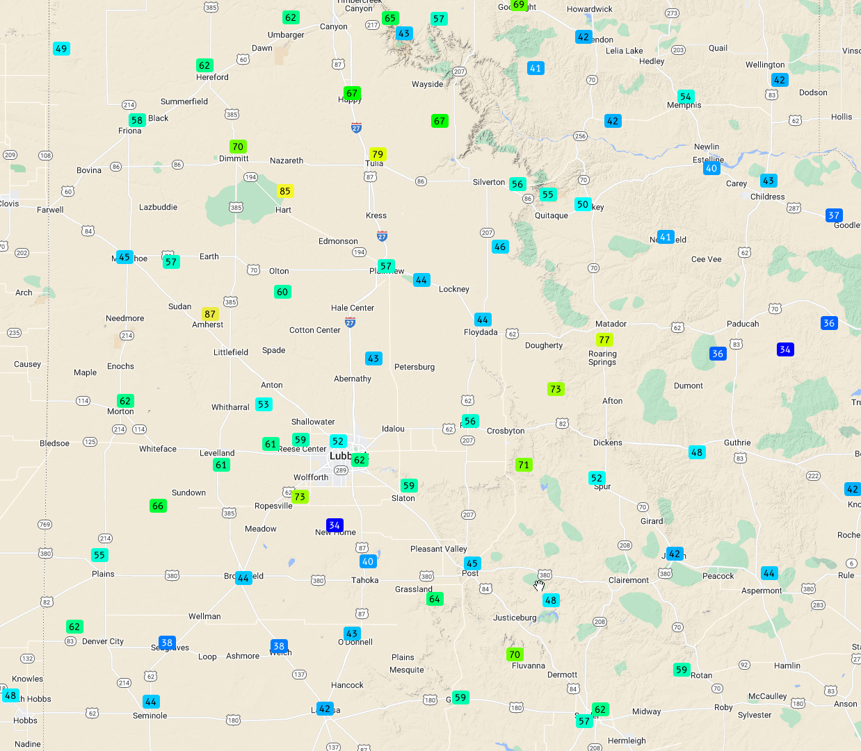
| Peak wind gusts measured by the West Texas Mesonet on 10 May 2022. | |||
|
Above are the peak wind gusts recorded by the West Texas Mesonet on Tuesday. Many locations recorded wind gusts in excess of 60 mph, with several sites breaching the 70-mph mark. Peak gusts of 87 mph and 85 mph occurred near Amherst and Hart, respectively. Fortunately, reported damage was fairly limited given the magnitude of the wind gusts. That said, a powerline was downed on Highway 385 just north of the Hockley County line and a large tree was knocked over near Tulia. |
|||
 |
|||
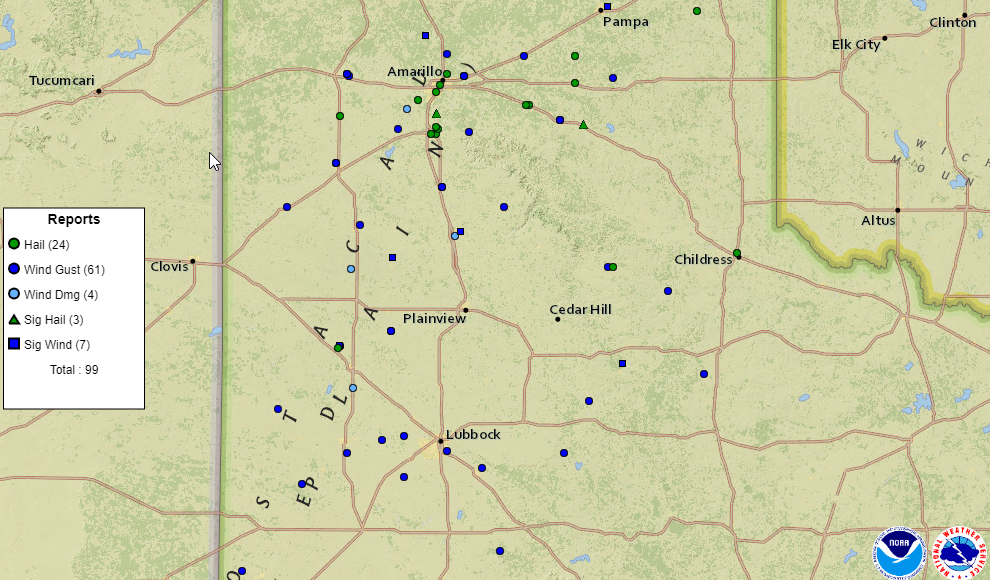
| Storm reports collected by the National Weather Service and displayed by the Storm Prediction Center for 10 May 2022. | |||
| The preliminary storm reports collected on this active mid-May day can be found below. | |||
PRELIMINARY LOCAL STORM REPORT...SUMMARY
NATIONAL WEATHER SERVICE LUBBOCK TX
1026 AM CDT WED MAY 11 2022

..TIME...   ...EVENT...      ...CITY LOCATION...     ...LAT.LON...
..DATE...   ....MAG....      ..COUNTY LOCATION..ST.. ...SOURCE....
            ..REMARKS..

0450 PM     TSTM WND GST     1 ENE MORTON            33.73N 102.74W
05/10/2022  M63 MPH          COCHRAN            TX   MESONET

            WEST TEXAS MESONET

0459 PM     TSTM WND GST     1 NE AMHERST            34.02N 102.40W
05/10/2022  M64 MPH          LAMB               TX   MESONET

            WEST TEXAS MESONET

0507 PM     HAIL             AMHERST                 34.01N 102.41W
05/10/2022  M1.00 INCH       LAMB               TX   LAW ENFORCEMENT

            MOSTLY PEA SIZED HAIL HOWEVER A FEW STONES UP TO
            QUARTER SIZED.

0550 PM     TSTM WND GST     1 NE AMHERST            34.02N 102.40W
05/10/2022  M66 MPH          LAMB               TX   MESONET

            WEST TEXAS MESONET INITIAL SEVERE GUST OF 63 AT 5:45
            PM. PEAK GUST AND LAST SEVERE GUST AT 5:50 PM.

0556 PM     TSTM WND GST     2 NE DIMMITT            34.57N 102.29W
05/10/2022  M70 MPH          CASTRO             TX   MESONET

            WEST TEXAS MESONET INITIAL SEVERE GUST OF 63 AT 5:54
            PM. SEVERE GUSTS OCCURRED THROUGH 5:58 PM WITH THE PEAK
            GUST REPORTED.

0602 PM     TSTM WND GST     1 NE AMHERST            34.02N 102.40W
05/10/2022  M87 MPH          LAMB               TX   MESONET

            WEST TEXAS MESONET INITIAL SEVERE GUST OF 58 AT 6:00
            PM. SEVERE GUSTS OCCURRED THROUGH 6:06 PM WITH THE PEAK
            GUST REPORTED.

0603 PM     TSTM WND GST     2 NE FRIONA             34.65N 102.69W
05/10/2022  M58 MPH          PARMER             TX   MESONET

            WEST TEXAS MESONET

0610 PM     TSTM WND DMG     LUMS CHAPEL             33.83N 102.33W
05/10/2022                   LAMB               TX   BROADCAST MEDIA

            POWERLINE DOWN ACROSS US 385 JUST NORTH OF THE HOCKLEY
            COUNTY LINE.

0612 PM     TSTM WND GST     3 N HART                34.42N 102.11W
05/10/2022  M82 MPH          CASTRO             TX   MESONET

            WEST TEXAS MESONET

0620 PM     TSTM WND DMG     3 NW SUNNYSIDE          34.37N 102.34W
05/10/2022                   CASTRO             TX   PUBLIC

            SOCIAL MEDIA REPORT OF FLIPPED CENTER PIVOTS. TIME
            ESTIMATED FROM RADAR.

0628 PM     TSTM WND GST     3 N HART                34.42N 102.11W
05/10/2022  M86 MPH          CASTRO             TX   MESONET

            WEST TEXAS MESONET HAS BEEN REPORTING OTHER SEVERE
            GUSTS CONTINOUSLY BETWEEN 6:27 PM AND 6:40 PM.

0639 PM     TSTM WND GST     HAPPY                   34.74N 101.84W
05/10/2022  M59 MPH          SWISHER            TX   MESONET

            WEST TEXAS MESONET

0652 PM     TSTM WND GST     6 S OLTON               34.09N 102.12W
05/10/2022  M60 MPH          LAMB               TX   MESONET

            WEST TEXAS MESONET

0658 PM     TSTM WND GST     2 ENE TULIA             34.54N 101.74W
05/10/2022  M79 MPH          SWISHER            TX   MESONET

            WEST TEXAS MESONET REPORTED SEVERE GUSTS FROM 6:53 PM
            THROUGH 7:22 PM. SEVERAL PEAK GUSTS OF 79 MPH WERE
            REPORTED AT 7:06 AND 7:07 PM AS WELL.

0658 PM     TSTM WND DMG     1 S TULIA               34.52N 101.77W
05/10/2022                   SWISHER            TX   PUBLIC

            DELAYED REPORT OF LARGE TREE FALLEN SOUTH OF TULIA.
            TIME ESTIMATED BY RADAR... **CORRECTION CHANGE TIME FROM
            AM TO PM**

0704 PM     TSTM WND GST     HAPPY                   34.74N 101.84W
05/10/2022  M67 MPH          SWISHER            TX   MESONET

            WEST TEXAS MESONET REPORTED CONTINOUS SEVERE GUSTS
            BETWEEN 7:02 PM AND 7:11 PM. INITIAL SEVERE GUST WAS
            REPORTED AT 6:39 PM AND LAST SEVERE GUST WAS REPORTED AT
            7:17 PM.

0722 PM     TSTM WND GST     VIGO PARK               34.65N 101.50W
05/10/2022  M67 MPH          SWISHER            TX   MESONET

            WEST TEXAS MESONET REPORTED OCCASIONAL SEVERE GUSTS
            BETWEEN 7:19 PM AND 7:31 PM.

0757 PM     TSTM WND GST     8 WSW SUNDOWN           33.39N 102.61W
05/10/2022  M66 MPH          COCHRAN            TX   MESONET

            WEST TEXAS MESONET

0800 PM     TSTM WND GST     7 WNW DENVER CITY       32.99N 102.94W
05/10/2022  M63 MPH          YOAKUM             TX   MESONET

            WEST TEXAS MESONET

0817 PM     TSTM WND GST     4 S LEVELLAND           33.53N 102.36W
05/10/2022  M61 MPH          HOCKLEY            TX   MESONET

            WEST TEXAS MESONET

0835 PM     DUST STORM       SMYER                   33.59N 102.16W
05/10/2022                   HOCKLEY            TX   BROADCAST MEDIA

            VIDEO OF NEAR ZERO VISIBILITY IN TOWN.

0840 PM     TSTM WND GST     SMYER                   33.59N 102.17W
05/10/2022  M61 MPH          HOCKLEY            TX   MESONET

            WEST TEXAS MESONET

0843 PM     TSTM WND GST     REESE CENTER            33.61N 102.05W
05/10/2022  M59 MPH          LUBBOCK            TX   MESONET

            WEST TEXAS MESONET

0902 PM     TSTM WND GST     6 S OLTON               34.09N 102.12W
05/10/2022  M58 MPH          LAMB               TX   MESONET

            WEST TEXAS MESONET

0909 PM     TSTM WND GST     5 SSW GRAHAM            33.08N 101.52W
05/10/2022  M64 MPH          GARZA              TX   MESONET

            WEST TEXAS MESONET

0915 PM     FLOOD            DENVER CITY             32.97N 102.83W
05/10/2022                   YOAKUM             TX   LAW ENFORCEMENT

            MAIN ROAD IN DENVER CITY WAS FLOODED DUE TO HEAVY RAIN.

0930 PM     TSTM WND GST     2 WNW BURRIS            33.54N 101.81W
05/10/2022  M63 MPH          LUBBOCK            TX   MESONET

            WEST TEXAS MESONET

0941 PM     TSTM WND GST     2 NE SLATON             33.46N 101.62W
05/10/2022  M59 MPH          LUBBOCK            TX   MESONET

            WEST TEXAS MESONET

0945 PM     TSTM WND GST     6 NW WHITE RIVER LAKE   33.53N 101.17W
05/10/2022  M71 MPH          CROSBY             TX   MESONET

            WEST TEXAS MESONET

0948 PM     HAIL             1 S TURKEY              34.38N 100.90W
05/10/2022  M1.00 INCH       HALL               TX   FIRE DEPT/RESCUE

            HAIL SLIGHTLY LARGER THAN A QUARTER REPORTED.

0948 PM     TSTM WND GST     6 SSW WOLFFORTH         33.42N 102.05W
05/10/2022  M73 MPH          LUBBOCK            TX   MESONET

            WEST TEXAS MESONET REPORTED SEVERE GUSTS BETWEEN 9:47
            PM AND 9:50 PM.

1004 PM     TSTM WND GST     3 NNW MCADOO            33.77N 101.03W
05/10/2022  M73 MPH          DICKENS            TX   MESONET

            WEST TEXAS MESONET REPORTED CONTINOUS SEVERE GUSTS FROM
            10:03 PM THROUGH 10:09 PM.

1018 PM     TSTM WND GST     3 N ROARING SPRINGS     33.94N 100.85W
05/10/2022  M77 MPH          MOTLEY             TX   MESONET

            WEST TEXAS MESONET REPORTED OCCASIONAL SEVERE GUSTS
            BETWEEN 10:18 PM AND 10:25 PM.

1040 PM     TSTM WND GST     2 WSW TURKEY            34.38N 100.93W
05/10/2022  M63 MPH          HALL               TX   MESONET

            WEST TEXAS MESONET

1043 PM     TSTM WND GST     1 S NORTHFIELD          34.27N 100.60W
05/10/2022  M72 MPH          MOTLEY             TX   MESONET

            WEST TEXAS MESONET REPORTED CONTINOUS SEVERE GUSTS FROM
            10:41 PM THROUGH 10:44 PM.

1046 PM     TSTM WND GST     10 SW PADUCAH           33.89N 100.40W
05/10/2022  M58 MPH          COTTLE             TX   MESONET

            WEST TEXAS MESONET

1106 PM     NON-TSTM WND GST 3 NNW MCADOO            33.77N 101.03W
05/10/2022  M63 MPH          DICKENS            TX   MESONET

1111 PM     HAIL             2 ENE CHILDRESS         34.44N 100.22W
05/10/2022  E1.00 INCH       CHILDRESS          TX   PUBLIC

1112 PM     FLOOD            1 SSE DOWNTOWN LUBBOCK  33.58N 101.84W
05/10/2022                   LUBBOCK            TX   EMERGENCY MNGR

            EMERGENCY MANAGEMENT REPORTED THE LEFT LANE OF SOUTH
            BOUND I-27 NEAR MILE MARKER 3 HAD STANDING WATER OVER
            THE ROADWAY RESULTING IN THE CLOSURE OF THIS LANE.

