
Dangerous heat will expand from the Gulf Coast into the Southern Plains and Desert Southwest through week's end. Additional extreme heat impacting the Pacific Northwest will shift to the northern Plains by the weekend. Tropical Storm Bertha is expected to continue to impact portions of the northwestern Gulf Coast from south central Louisiana to the upper Texas coast today. Read More >
|
Wind for all, dust for most, rain for some |
|||||
 |
|||||
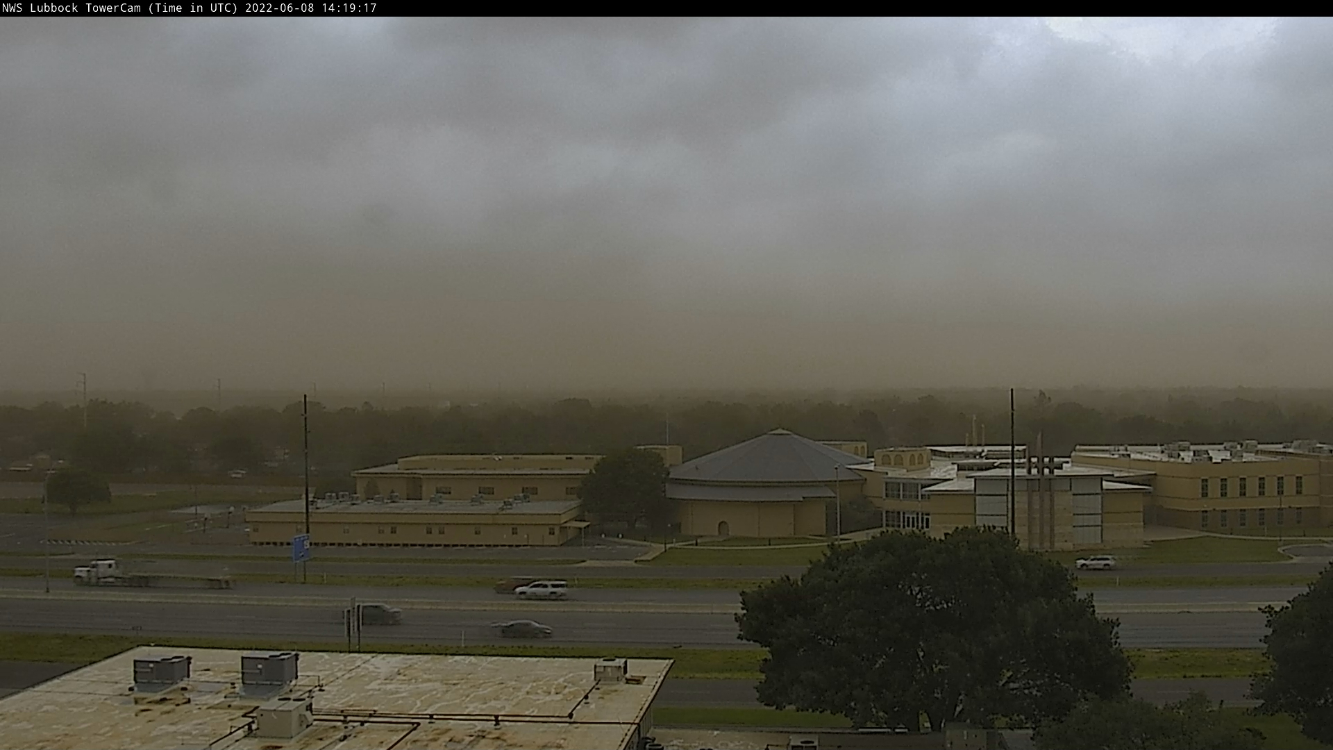
| Dusty and windy view from the southern parts of Lubbock captured at 8:19 am on 8 June 2022. | |||||
|
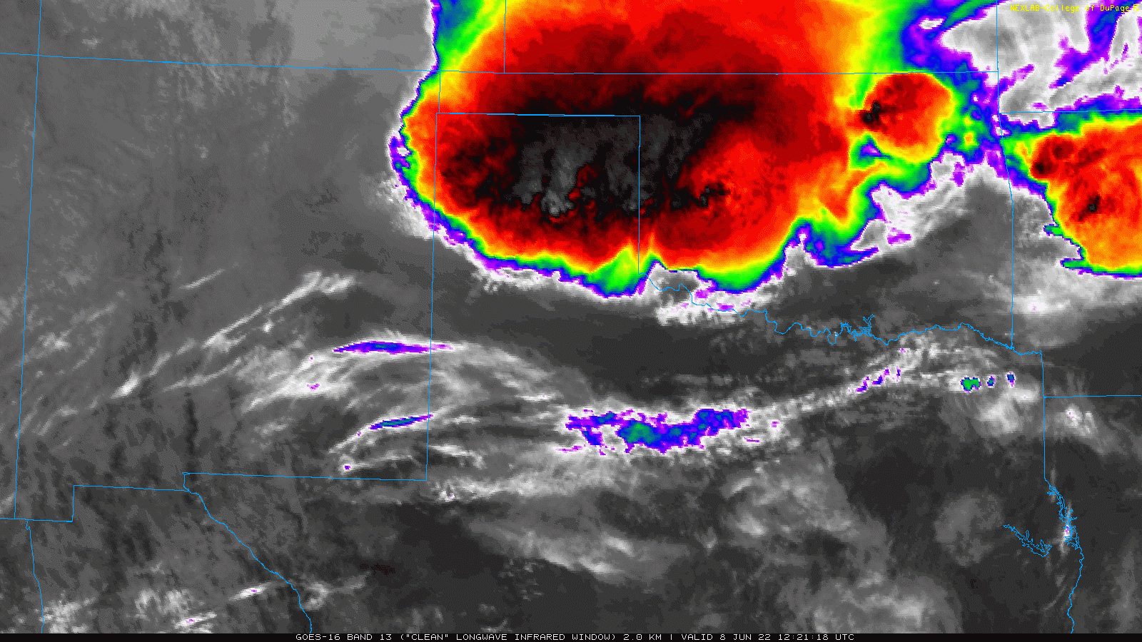
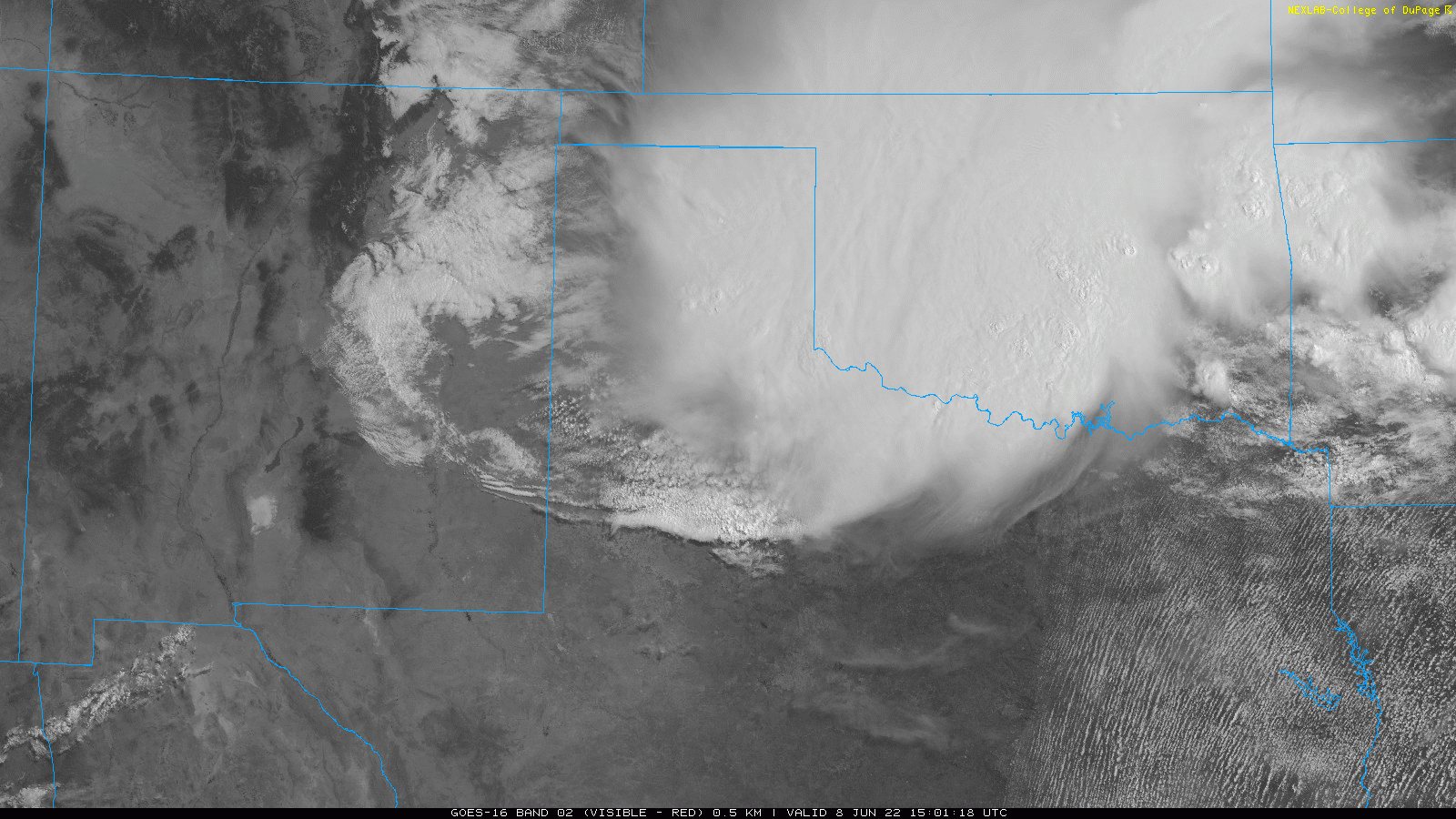
Early Wednesday morning, June 8th, started off with a bang. A complex of thunderstorms that initially developed over eastern Colorado and western Kansas around midnight, grew in size and strength as it accelerated southward across much of the Oklahoma and Texas Panhandles during the predawn hours. |
|||||
 |
|||||
|
|||||
|
A few instances of large hail occurred with this complex, but the main impact was the widespread intense winds that it generated as it plunged southward. The leading edge of the winds raced out of the southern Texas Panhandle and across the South Plains and Rolling Plains between 7:30 and 10 am, lofting dust and causing damage in spots. |
|||||
 |
|||||
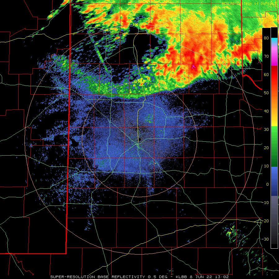
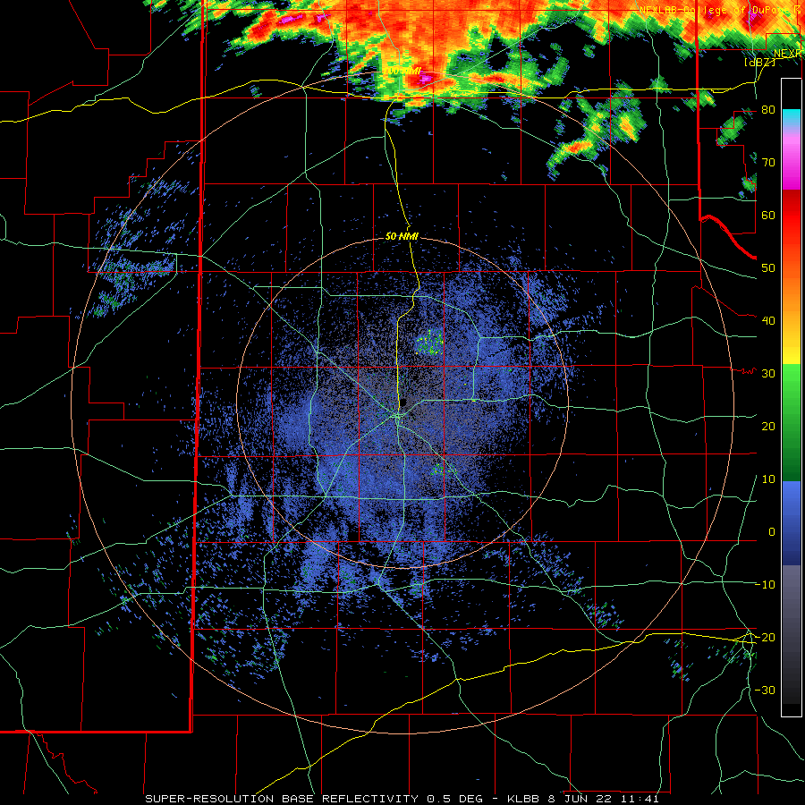
| Lubbock WSR-88D radar animation valid from 8:05 am to 9:52 am on 8 June 2022. An additional radar animation, valid from 6:45 am to 9:52 am, can be VIEWED HERE. | |||||
|
The outflow winds pushed out well ahead of the complex of thunderstorms that generated the wind, but that didn't stop them from sweeping into the Permian Basin, Big Country and beyond. Unfortunately, the rainfall was much more limited, with the showers and thunderstorms struggling to advance and develop much past the northeastern South Plains and northern Rolling Plains. |
|||||
 |
|||||
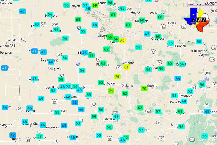
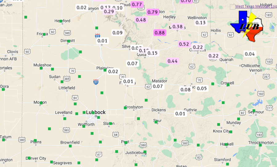
| Maximum wind gusts recorded by the West Texas Mesonet early Wednesday morning (8 June 2022). | |||||
| Wind gusts were impressive, especially for so early in the day. Widespread gusts of 50 to 65 mph were measured by the West Texas Mesonet from the Texas Panhandle through the Rolling Plains and eastern South Plains. Many of these severe gusts occurred well in advance of any shower and t-storm activity. The strongest winds, as high as 80+ mph, were measured near Turkey and Matador, where tree damage was reported. | |||||
 |
|||||
|
|||||
| The wind also lofted a lot of blowing dust, creating a haboob as the leading edge of the outflow raced south and east of the South and Rolling Plains. Visibility briefly dropped very low as the initial gust front and wall of dust moved through. | |||||
 |
|||||
|
|||||
|
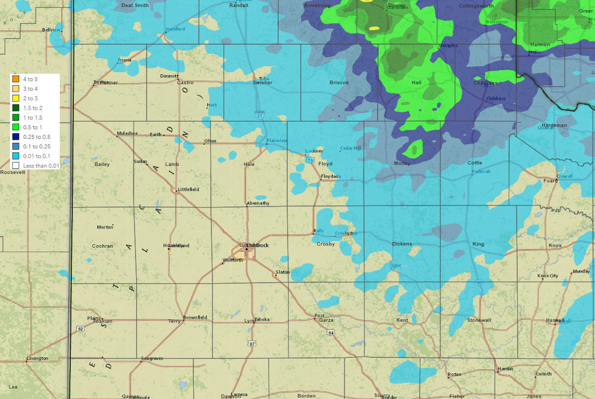
Rainfall was much more limited than the wind and dust, confined primarily to the southeast Texas Panhandle and northern Rolling Plains. Much of Hall County and portions of Childress County saw rain totals near or in excess of a half inch. Officially, the Childress Airport measured 0.34 inches of rainfall, while also recording a 58 mph wind gust. Lubbock only reported a trace of precipitation, but did experience dust and a 65 mph wind gust as the outflow moved through. The preliminary storm reports collected on this active early June morning can be found below: |
|||||
PRELIMINARY LOCAL STORM REPORT...SUMMARY
NATIONAL WEATHER SERVICE LUBBOCK TX
1133 AM CDT WED JUN 8 2022

..TIME...   ...EVENT...      ...CITY LOCATION...     ...LAT.LON...
..DATE...   ....MAG....      ..COUNTY LOCATION..ST.. ...SOURCE....
            ..REMARKS..

0731 AM     TSTM WND GST     1 E HAPPY               34.74N 101.84W
06/08/2022  M63 MPH          SWISHER            TX   MESONET

            WEST TEXAS MESONET. A GUST TO 60 MPH ALSO
            OCCURRED AT 7:33 AM.

0758 AM     TSTM WND GST     17 WSW MEMPHIS          34.63N 100.82W
06/08/2022  M63 MPH          HALL               TX   MESONET

            LESLEY WEST TEXAS MESONET REPORT.

0801 AM     TSTM WND GST     7 ESE SILVERTON         34.43N 101.19W
06/08/2022  M66 MPH          BRISCOE            TX   MESONET

            WEST TEXAS MESONET. WIND GUSTS OF 58 TO 66
            MPH OCCURRED BETWEEN 7:59 AM AND 8:02 AM.

0805 AM     TSTM WND GST     CAPROCK CANYON SP VISIT 34.45N 101.07W
06/08/2022  M64 MPH          BRISCOE            TX   MESONET

            MEASURED BY THE WEST TEXAS MESONET.

0810 AM     TSTM WND GST     2 WSW TURKEY            34.38N 100.93W
06/08/2022  M62 MPH          HALL               TX   MESONET

            WEST TEXAS MESONET.

0810 AM     TSTM WND GST     2 NNE CHILDRESS         34.45N 100.23W
06/08/2022  M60 MPH          CHILDRESS          TX   MESONET

            WEST TEXAS MESONET.

0811 AM     TSTM WND GST     2 W CHILDRESS           34.42N 100.28W
06/08/2022  M58 MPH          CHILDRESS          TX   ASOS

            CHILDRESS MUNICIPAL AIRPORT.

0812 AM     TSTM WND GST     2 WSW TURKEY            34.38N 100.93W
06/08/2022  M82 MPH          HALL               TX   MESONET

            PEAK GUST MEASURED BY THE TURKEY WEST TEXAS
            MESONET. WIND GUSTS OF 58 TO 82 MPH OCCURRED
            FROM 8:10 AM TO 8:16 AM, WITH ANOTHER SEVERE
            GUST AT 8:20 AM.

0815 AM     TSTM WND GST     3 ENE SOUTH PLAINS      34.24N 101.26W
06/08/2022  M62 MPH          FLOYD              TX   MESONET

            WEST TEXAS MESONET. WIND GUSTS OF 59 TO 62
            MPH FROM 8:14 TO 8:16 AM.

0818 AM     TSTM WND GST     1 NE MEMPHIS            34.74N 100.53W
06/08/2022  M60 MPH          HALL               TX   MESONET

            WEST TEXAS MESONET.

0822 AM     TSTM WND GST     3 WSW AIKEN             34.13N 101.57W
06/08/2022  M59 MPH          HALE               TX   MESONET

            WEST TEXAS MESONET.

0840 AM     TSTM WND GST     2 NNE FLOYDADA          34.01N 101.32W
06/08/2022  M62 MPH          FLOYD              TX   MESONET

            WEST TEXAS MESONET. WIND GUSTS OF 58 TO 62
            MPH OCCURRED BETWEEN 8:32 AM AND 8:40 AM.

0844 AM     TSTM WND GST     3 N ROARING SPRINGS     33.94N 100.86W
06/08/2022  M81 MPH          MOTLEY             TX   MESONET

            WEST TEXAS MESONET. WIND GUSTS OF 65 TO 81
            MPH FROM 8:43 TO 8:45 AM.

0850 AM     TSTM WND GST     14 NE CROSBYTON         33.79N 101.07W
06/08/2022  M71 MPH          CROSBY             TX   MESONET

            MEASURED BY THE MCADOO WEST TEXAS MESONET.

0854 AM     TSTM WND GST     14 NE CROSBYTON         33.79N 101.07W
06/08/2022  M76 MPH          CROSBY             TX   MESONET

            MCADOO WEST TEXAS MESONET. SEVERE GUSTS
            STARTED AT 8:50 AM AND WERE CONTINUING
            THROUGH 8:55 AM (LATEST REPORT).

0858 AM     TSTM WND GST     2 SSE HACKBERRY         33.90N 100.14W
06/08/2022  M59 MPH          COTTLE             TX   MESONET

            59 MPH AT 8:58 CDT AND 8:59 CDT.

0900 AM     TSTM WND GST     1 SE RALLS              33.67N 101.37W
06/08/2022  M58 MPH          CROSBY             TX   MESONET

            WEST TEXAS MESONET.

0902 AM     TSTM WND GST     6 SSW ANTON             33.73N 102.20W
06/08/2022  M58 MPH          HOCKLEY            TX   MESONET


0903 AM     TSTM WND GST     1 SE RALLS              33.67N 101.37W
06/08/2022  M60 MPH          CROSBY             TX   MESONET

            WEST TEXAS MESONET. SEVERE GUSTS OCCURRED
            BETWEEN 9 AND 9:03 AM.

0905 AM     TSTM WND GST     LUBBOCK INT. AIRPORT    33.65N 101.81W
06/08/2022  M64 MPH          LUBBOCK            TX   ASOS

            VISIBILITY DOWN TO 2-1/2 MI DUE TO BLDU.

0908 AM     TSTM WND GST     6 NW WHITE RIVER LAKE   33.54N 101.17W
06/08/2022  M71 MPH          CROSBY             TX   MESONET

            WEST TEXAS MESONET. WIND GUSTS FROM 67 TO 71
            MPH BETWEEN 9:06 AM AND 9:08 AM.

0918 AM     TSTM WND GST     10 WSW GUTHRIE          33.57N 100.48W
06/08/2022  M70 MPH          KING               TX   MESONET


0920 AM     TSTM WND GST     1 W SPUR                33.63N 100.34W
06/08/2022  M62 MPH          KING               TX   MESONET


0940 AM     TSTM WND GST     1 SSE JAYTON            33.24N 100.57W
06/08/2022  M62 MPH          KENT               TX   MESONET

            WEST TEXAS MESONET. SEVERE GUST OCCURRED
            WELL AHEAD OF THE THUNDERSTORMS.

1012 AM     TSTM WND GST     5 SSW GRAHAM            33.08N 101.50W
06/08/2022  M59 MPH          GARZA              TX   MESONET

            WEST TEXAS MESONET. ASSOCIATED WITH A WEAK
            SHOWER BEHIND A STRONG GUST FRONT. SEVERE
            GUSTS OCCURRED BETWEEN 10:04 AM AND 10:12
            AM.

