
Dangerous heat will expand from the Gulf Coast into the Southern Plains and Desert Southwest through week's end. Additional extreme heat impacting the Pacific Northwest will shift to the northern Plains by the weekend. Tropical Storm Bertha is expected to continue to impact portions of the northwestern Gulf Coast from south central Louisiana to the upper Texas coast today. Read More >
|
Arctic air invades West Texas |
|||||
 |
|||||
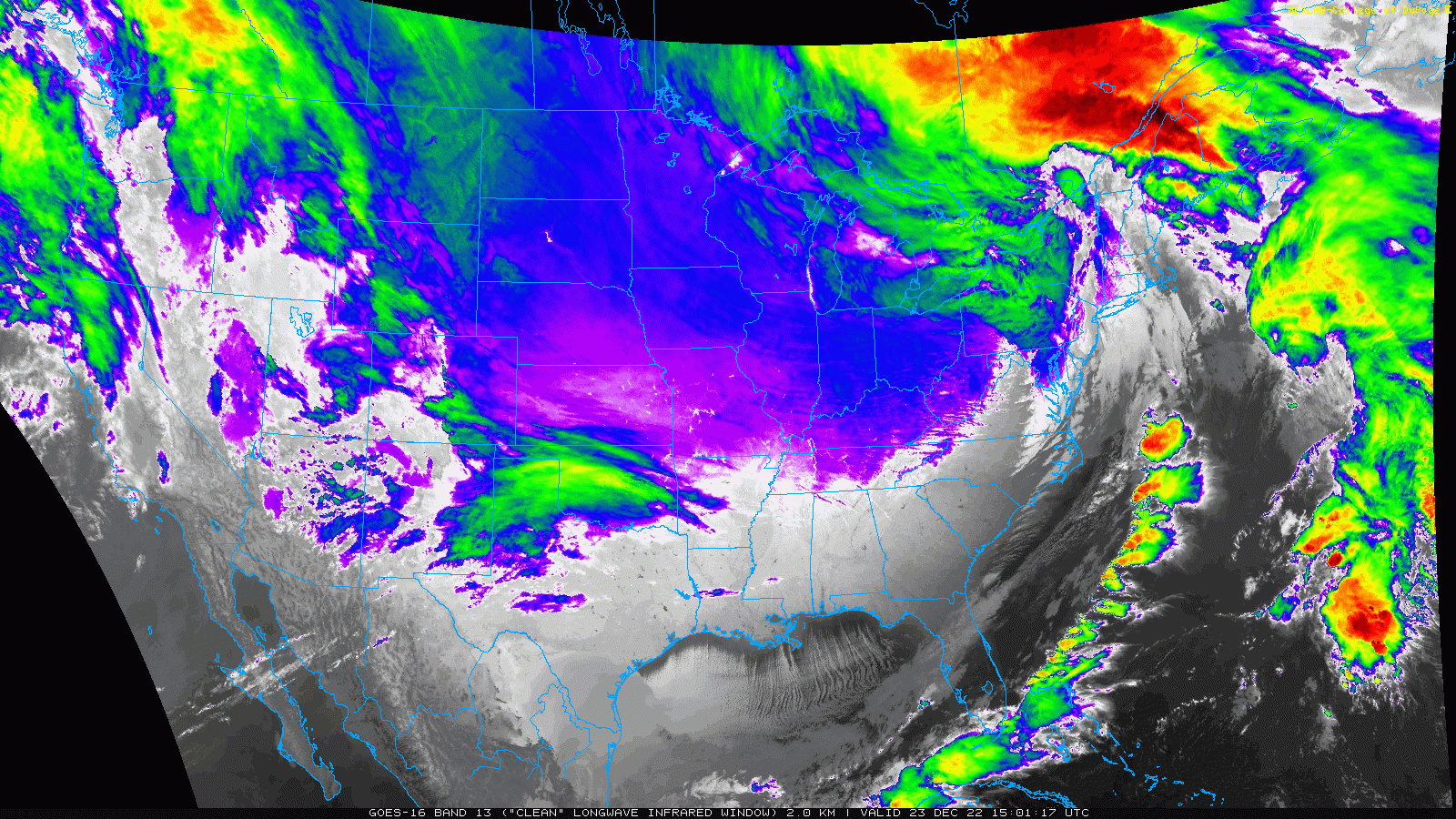
| Infrared satellite loop valid from 5:56 am to 7:11 am on 22 December 2022. The lighter whites and purples spreading southward through northwest Texas is progressively colder air. | |||||
|
The coldest air of the season invaded Texas on Thursday, December 22nd, 2022. The air of arctic origin raced southward out of the Texas Panhandle and through the South Plains in the predawn hours. Temperatures in the 30s and 40s were common in advance of the front, but quickly plunged into the teens and single digits behind the cold front. |
|||||
 |
|||||
|
|||||
|
The above plot shows the temperatures at 7 am on Thursday, not too long before sunrise. A clear division between the mild and relatively moist air over southern sections and bitterly cold air from the South Plains and Rolling Plains northward is evident. |
|||||
 |
|||||
|
|||||
|
Adding insult to injury, the arrival of the frigid air was accompanied by strong and gusty north winds commonly sustained in the 25 to 35 mph range. The combination pushed wind chills well below zero, with many locations recording wind chill values as low as -15ËšF to -30ËšF degrees Thursday morning. The coldest readings were felt across the southwest Texas Panhandle, though the entire region felt the bitterly cold air. |
|||||
 |
|||||
| Lubbock WSR-88D radar animation valid from 1:00 am to 7:06 am on 22 December 2022. A fine line indicates the leading edge of the arctic air as it moved through the South Plains. | |||||
| In addition to the cold, the air that invaded was extremely dry. Although a few flurries were reported at a couple of spots immediately behind the cold front, overall the arctic air invasion was a dry one. This was welcome because roadways remained in good shape as travel ramped up leading into the Christmas Holiday Weekend. | |||||
 |
|||||
| Plot of the official temperature measured at Lubbock from December 20th through the 23rd. A similar plot for Childress can be VEIWED HERE. | |||||
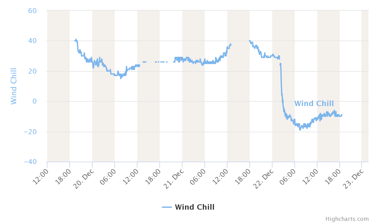
| The above and below graphs show the rapid temperature (above) and wind chill (below) drop immediately following the passage of the arctic cold front at Lubbock early on the morning of the 22nd. The temperature fell from around 40ËšF to under 10ËšF all before daybreak on Thursday. Similarly, wind chill values plummeted from the 30s to below -10ËšF. | |||||
 |
|||||
| Plot of the official wind chill measured at Lubbock from December 20th through the 23rd. A similar plot for Childress can be VEIWED HERE. | |||||
| The incredible temperature drop was not confined to West Texas. As the below map illustrates, temperatures fell 25ËšF or more in 30-minutes over much of the central High Plains as the cold front moved through. Although not quite as large, impressive temperature drops also affected much of the rest of Texas and a good chunk of the central and southern Plains. | |||||
 |
|||||
| Maximum 30-minute temperature drop December 21st through 22nd. The image is courtesy of Brian Brettschneider. | |||||
| The wind gradually decreased Thursday afternoon and evening, setting the stage for the coldest night of this late December stretch. Lows Friday morning (23 December) bottomed out in the bone-chilling single digits at most locations. It could have been even a bit colder, but a thick batch of middle-high clouds moved over early Friday which tempered the temperature drop. | |||||
 |
|||||
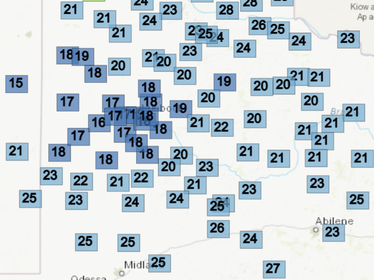
| Low temperatures measured on Friday morning (23 December 2022). The data are courtesy of the West Texas Mesonet. High temperatures observed on Friday can be FOUND HERE. Saturday morning's (24 December 2022) lows can be VIEWED HERE. | |||||
| However, the same cloud cover that limited how low the temperatures fell Friday morning also kept temperatures from rising much during the day. Highs Friday only reached the upper teens and lower 20s before temperatures dipped back down into the single digits and teens Friday night. | |||||
 |
|||||
| Infrared satellite loop valid from 9:01 am to 9:41 am on 23 December 2022. The lighter whites, blues and purples across much of the Midwest and Great Plains represent very cold air. The green area moving eastward over eastern New Mexico, northwest Texas and Oklahoma are high clouds which have even colder cloud top temperatures than are at ground level over the Midwest. | |||||
| The above satellite loop shows just how expansive the cold air was the morning of the 23rd, encompassing much of the central and eastern United States. The entire state of Texas, including all of South Texas, reported subfreezing low temperatures. Very impressive, especially given the fact that no snow or ice (other than recently frozen ponds and lakes) was present on the ground. | |||||
| Preliminary wind chill reports from around the South Plains region for the morning of December 22nd can be found below: | |||||
PRELIMINARY LOCAL STORM REPORT
NATIONAL WEATHER SERVICE LUBBOCK TX
1041 AM CST THU DEC 22 2022

...LOWEST WIND CHILLS THROUGH 1030 AM CST...

..TIME...   ...EVENT...      ...CITY LOCATION...     ...LAT.LON...
..DATE...   ....MAG....      ..COUNTY LOCATION..ST.. ...SOURCE....
            ..REMARKS..

0745 AM     EXTR WIND CHILL  2 NE DIMMITT            34.57N 102.29W
12/22/2022  M-29 F           CASTRO             TX   MESONET

            WEST TEXAS MESONET

0734 AM     EXTR WIND CHILL  2 ENE TULIA             34.54N 101.74W
12/22/2022  M-28 F           SWISHER            TX   MESONET

            WEST TEXAS MESONET

0755 AM     EXTR WIND CHILL  8 NNW MACKENZIE RESERVO 34.65N 101.50W
12/22/2022  M-28 F           SWISHER            TX   MESONET

            WEST TEXAS MESONET

0808 AM     EXTR WIND CHILL  1 E HAPPY               34.74N 101.84W
12/22/2022  M-28 F           SWISHER            TX   MESONET

            WEST TEXAS MESONET

0808 AM     EXTR WIND CHILL  2 ENE FRIONA            34.65N 102.69W
12/22/2022  M-27 F           PARMER             TX   MESONET

            WEST TEXAS MESONET

0753 AM     EXTR WIND CHILL  6 S OLTON               34.09N 102.12W
12/22/2022  M-26 F           LAMB               TX   MESONET

            WEST TEXAS MESONET

0758 AM     EXTR WIND CHILL  3 N HART                34.42N 102.11W
12/22/2022  M-26 F           CASTRO             TX   MESONET

            WEST TEXAS MESONET

0803 AM     EXTR WIND CHILL  9 NNW SUDAN             34.19N 102.56W
12/22/2022  M-25 F           LAMB               TX   MESONET

            WEST TEXAS MESONET

0806 AM     EXTR WIND CHILL  4 NW KALGARY            33.45N 101.19W
12/22/2022  M-25 F           CROSBY             TX   MESONET

            WEST TEXAS MESONET

0817 AM     EXTR WIND CHILL  3 WSW AIKEN             34.13N 101.57W
12/22/2022  M-24 F           HALE               TX   MESONET

            WEST TEXAS MESONET

0818 AM     EXTR WIND CHILL  1 SE PLAINVIEW          34.18N 101.71W
12/22/2022  M-24 F           HALE               TX   MESONET

            WEST TEXAS MESONET

0820 AM     EXTR WIND CHILL  3 ENE SOUTH PLAINS      34.24N 101.26W
12/22/2022  M-24 F           FLOYD              TX   MESONET

            WEST TEXAS MESONET

0808 AM     EXTR WIND CHILL  2 S CAPROCK CANYON SP V 34.41N 101.07W
12/22/2022  M-23 F           BRISCOE            TX   MESONET

            WEST TEXAS MESONET

0817 AM     EXTR WIND CHILL  1 NE AMHERST            34.02N 102.40W
12/22/2022  M-23 F           LAMB               TX   MESONET

            WEST TEXAS MESONET

0818 AM     EXTR WIND CHILL  6 ENE ABERNATHY         33.88N 101.76W
12/22/2022  M-23 F           HALE               TX   MESONET

            WEST TEXAS MESONET

0805 AM     EXTR WIND CHILL  1 ENE MEMPHIS           34.73N 100.53W
12/22/2022  M-22 F           HALL               TX   MESONET

            WEST TEXAS MESONETE.

0809 AM     EXTR WIND CHILL  1 NNE FLOYDADA          34.00N 101.33W
12/22/2022  M-22 F           FLOYD              TX   MESONET

            WEST TEXAS MESONET

0818 AM     EXTR WIND CHILL  2 SSW MULESHOE          34.21N 102.74W
12/22/2022  M-22 F           BAILEY             TX   MESONET

            WEST TEXAS MESONET

0713 AM     EXTR WIND CHILL  6 SE BRICE              34.65N 100.81W
12/22/2022  M-21 F           HALL               TX   MESONET

            WEST TEXAS MESONET

0741 AM     EXTR WIND CHILL  2 WSW TURKEY            34.38N 100.93W
12/22/2022  M-21 F           HALL               TX   MESONET

            WEST TEXAS MESONET

0751 AM     EXTR WIND CHILL  6 SSW ANTON             33.73N 102.19W
12/22/2022  M-21 F           HOCKLEY            TX   MESONET

            WEST TEXAS MESONET

0815 AM     EXTR WIND CHILL  1 E CEDAR HILL          34.14N 101.19W
12/22/2022  M-21 F           FLOYD              TX   MESONET

            WEST TEXAS MESONET

0816 AM     EXTR WIND CHILL  4 NE CHILDRESS          34.46N 100.20W
12/22/2022  M-21 F           CHILDRESS          TX   MESONET

            WEST TEXAS MESONET

0818 AM     EXTR WIND CHILL  2 NW REESE CENTER       33.61N 102.05W
12/22/2022  M-21 F           LUBBOCK            TX   MESONET

            WEST TEXAS MESONET

0807 AM     EXTR WIND CHILL  6 E ROPESVILLE          33.42N 102.05W
12/22/2022  M-20 F           LUBBOCK            TX   MESONET

            WEST TEXAS MESONET

0807 AM     EXTR WIND CHILL  1 ENE MORTON            33.73N 102.74W
12/22/2022  M-20 F           COCHRAN            TX   MESONET

            WEST TEXAS MESONET

0810 AM     EXTR WIND CHILL  8 SW SUNDOWN            33.39N 102.61W
12/22/2022  M-20 F           COCHRAN            TX   MESONET

            WEST TEXAS MESONET

0817 AM     EXTR WIND CHILL  3 NNE ROARING SPRINGS   33.94N 100.85W
12/22/2022  M-20 F           MOTLEY             TX   MESONET

            WEST TEXAS MESONET

0820 AM     EXTR WIND CHILL  4 S LEVELLAND           33.53N 102.36W
12/22/2022  M-20 F           HOCKLEY            TX   MESONET

            WEST TEXAS MESONET

0826 AM     EXTR WIND CHILL  3 NNE ROARING SPRINGS   33.94N 100.85W
12/22/2022  M-20 F           MOTLEY             TX   MESONET

            WEST TEXAS MESONET

0815 AM     EXTR WIND CHILL  2 SSW LEVELLAND         33.55N 102.37W
12/22/2022  M-19 F           HOCKLEY            TX   MESONET

            WEST TEXAS MESONET

0715 AM     EXTR WIND CHILL  1 WNW HALE CENTER       34.07N 101.85W
12/22/2022  M-18 F           HALE               TX   MESONET

            WEST TEXAS MESONET

0731 AM     EXTR WIND CHILL  2 NW TEXAS TECH UNIV.   33.60N 101.90W
12/22/2022  M-18 F           LUBBOCK            TX   MESONET

            WEST TEXAS MESONET

0748 AM     EXTR WIND CHILL  4 SSE ESTELLINE         34.50N 100.42W
12/22/2022  M-18 F           HALL               TX   MESONET

            WEST TEXAS MESONET

0800 AM     EXTR WIND CHILL  1 SE RALLS              33.67N 101.38W
12/22/2022  M-18 F           CROSBY             TX   MESONET

            WEST TEXAS MESONET

0808 AM     EXTR WIND CHILL  2 NE SLATON             33.46N 101.62W
12/22/2022  M-18 F           LUBBOCK            TX   MESONET

            WEST TEXAS MESONET

0829 AM     EXTR WIND CHILL  4 SSE ESTELLINE         34.50N 100.42W
12/22/2022  M-18 F           HALL               TX   MESONET

            WEST TEXAS MESONET

0653 AM     EXTR WIND CHILL  2 WNW CHILDRESS         34.43N 100.28W
12/22/2022  M-17 F           CHILDRESS          TX   ASOS

            ASOS STATION KCDS CHILDRESS.

0733 AM     EXTR WIND CHILL  1 N LUBBOCK INT. AIRPOR 33.67N 101.82W
12/22/2022  M-17 F           LUBBOCK            TX   ASOS

            ASOS STATION KLBB LUBBOCK.

0807 AM     EXTR WIND CHILL  2 S BROWNFIELD          33.15N 102.27W
12/22/2022  M-17 F           TERRY              TX   MESONET

            WEST TEXAS MESONET

0816 AM     EXTR WIND CHILL  1 N DELWIN              33.89N 100.40W
12/22/2022  M-17 F           COTTLE             TX   MESONET

            WEST TEXAS MESONET

0410 AM     EXTR WIND CHILL  2 SSE PLAINVIEW         34.17N 101.72W
12/22/2022  M-16 F           HALE               TX   AWOS

            AWOS STATION KPVW PLAINVIEW.

0731 AM     EXTR WIND CHILL  1 SSW NORTHFIELD        34.27N 100.60W
12/22/2022  M-16 F           MOTLEY             TX   MESONET

            WEST TEXAS MESONET

0807 AM     EXTR WIND CHILL  3 SSE CAPROCK CANYON SP 34.41N 101.05W
12/22/2022  M-16 F           BRISCOE            TX   MESONET

            WEST TEXAS MESONET

0810 AM     EXTR WIND CHILL  3 NNE TAHOKA            33.21N 101.78W
12/22/2022  M-16 F           LYNN               TX   MESONET

            WEST TEXAS MESONET

0810 AM     EXTR WIND CHILL  2 SSE HACKBERRY         33.90N 100.13W
12/22/2022  M-16 F           COTTLE             TX   MESONET

            WEST TEXAS MESONET

0820 AM     EXTR WIND CHILL  3 NNW PLAINS            33.23N 102.84W
12/22/2022  M-16 F           YOAKUM             TX   MESONET

            WEST TEXAS MESONET

0820 AM     EXTR WIND CHILL  4 E REESE CENTER        33.60N 101.96W
12/22/2022  M-16 F           LUBBOCK            TX   MESONET

            WEST TEXAS MESONET

0829 AM     EXTR WIND CHILL  1 N O DONNELL           32.98N 101.83W
12/22/2022  M-16 F           LYNN               TX   MESONET

            WEST TEXAS MESONET

0755 AM     EXTR WIND CHILL  2 SSW LEVELLAND         33.55N 102.37W
12/22/2022  M-15 F           HOCKLEY            TX   MESONET

            WEST TEXAS MESONET

0806 AM     EXTR WIND CHILL  10 WSW GUTHRIE          33.57N 100.48W
12/22/2022  M-15 F           KING               TX   MESONET

            WEST TEXAS MESONET

0818 AM     EXTR WIND CHILL  NEW HOME                33.33N 101.91W
12/22/2022  M-15 F           LYNN               TX   MESONET

            WEST TEXAS MESONET.

0820 AM     EXTR WIND CHILL  5 NW WHITE RIVER LAKE   33.53N 101.17W
12/22/2022  M-15 F           CROSBY             TX   MESONET

            WEST TEXAS MESONET

0826 AM     EXTR WIND CHILL  6 WNW DENVER CITY       32.99N 102.94W
12/22/2022  M-15 F           YOAKUM             TX   MESONET

            WEST TEXAS MESONET
|
|||||

