|
Wednesday brings the wind and dust |
|||||
 |
|||||
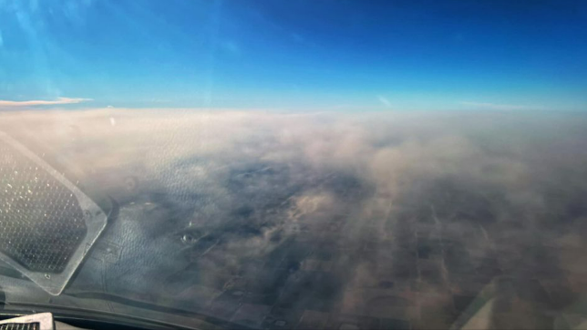
| View of the dust over the South Plains from 24,000 feet on Wednesday afternoon (11 January 2023). The picture is courtesy of Jerry Fletcher and Jacob Riley. | |||||
|
Early 2023 brought several days of gusty winds to the region thanks to a progressive weather pattern that featured storm systems racing by to our north every few days. The most intense of these early-January systems resulted in widespread strong to severe wind gusts raking West Texas on the afternoon of Wednesday, January 11th. |
|||||
 |
|||||
|
|||||
|
As is typically seen, the deafening winds managed to lift copious amounts of dust across eastern New Mexico and West Texas. The blowing dust dropped the visibility and painted an eerie red-brown hue across the skyline during the afternoon and early evening before beginning to settle out. |
|||||
 |
|||||
|
|||||
|
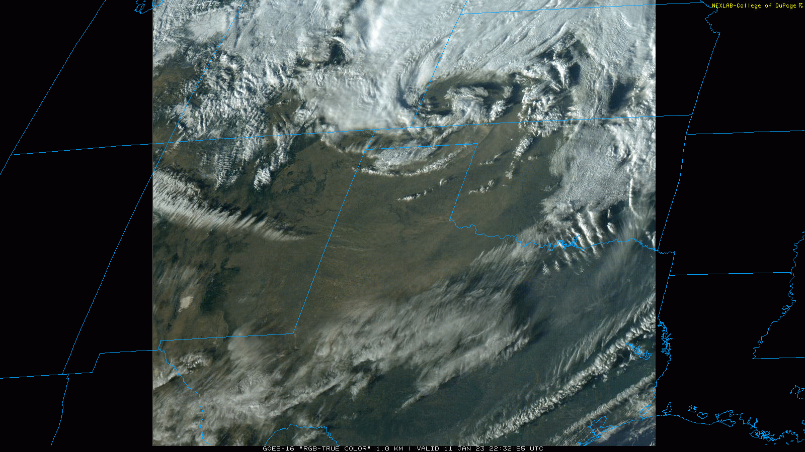
The above image shows what the dust looked like at ground level near Seminole Wednesday afternoon, while the below animation is what the swaths of dust looked like from space. Several thicker bands of dust dropped the visibility to a mile or less at its peak, which made driving difficult, at times. |
|||||
 |
|||||
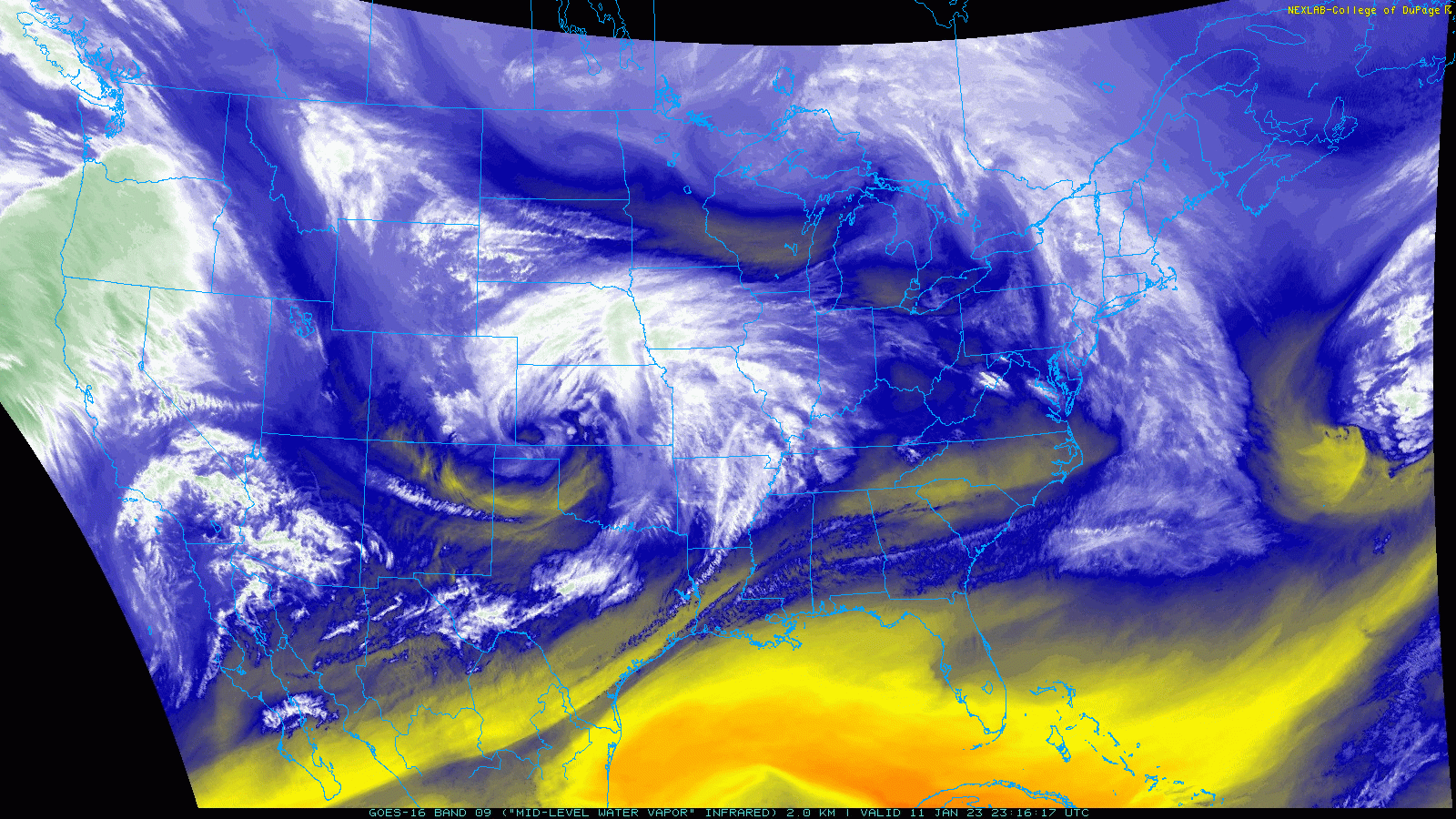
| Visible satellite animation valid from 5:32 pm to 5:48 pm on Wednesday (11 January 2023). | |||||
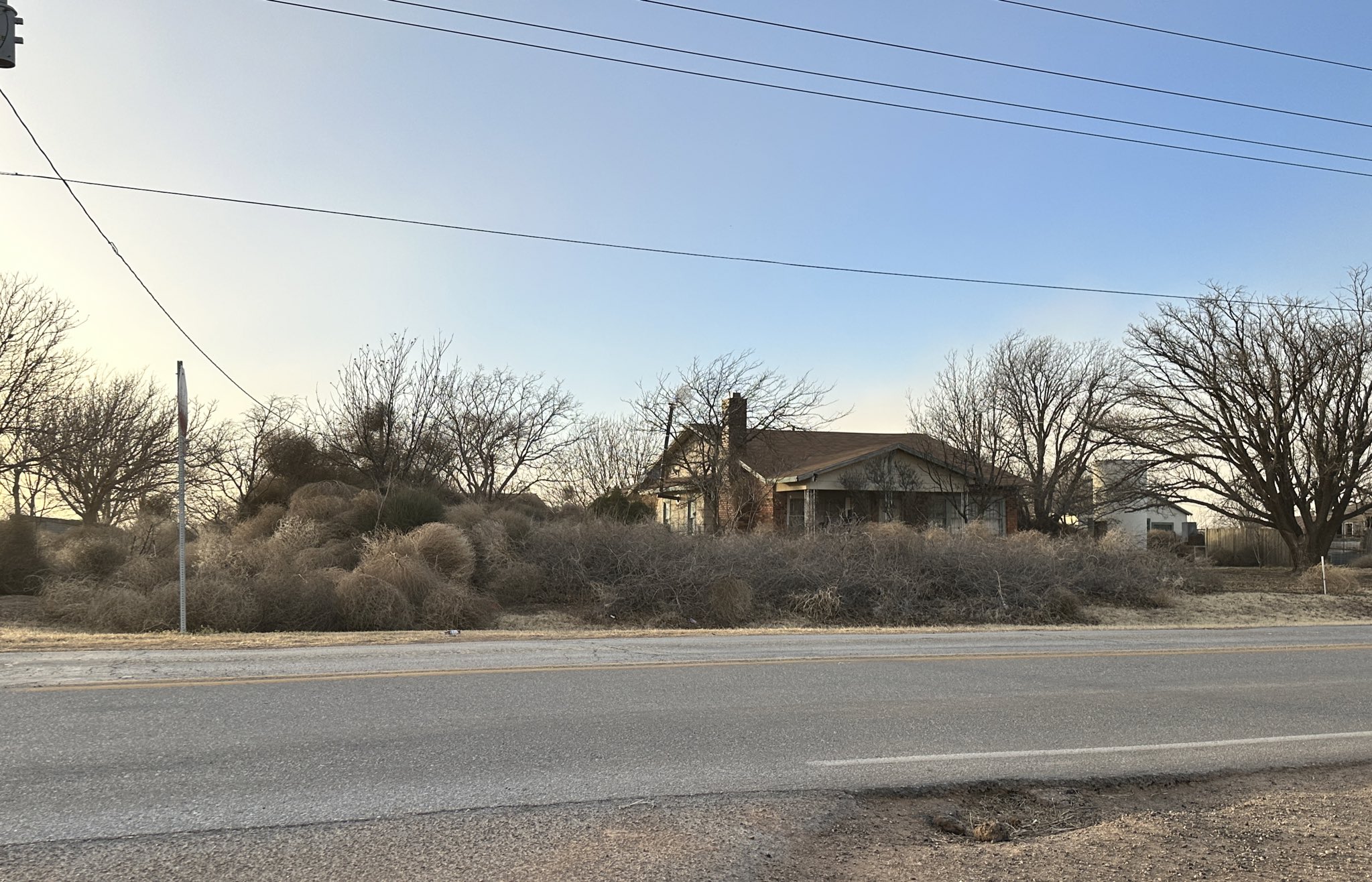
| In addition to kicking up all the dust, the windy days in early 2023 transported vast numbers of tumbleweeds across the open plains. When the tumbleweeds encountered a blockage, like the homestead below, they accumulated in vast numbers. The tumbleweed gatherings were impressive to see, but were quite a nuisance for those that were directly affected to deal with. | |||||
 |
|||||
| A "family" of tumbleweeds gathered around a homestead in early January 2023. The image is courtesy of Larry Rodriguez. | |||||
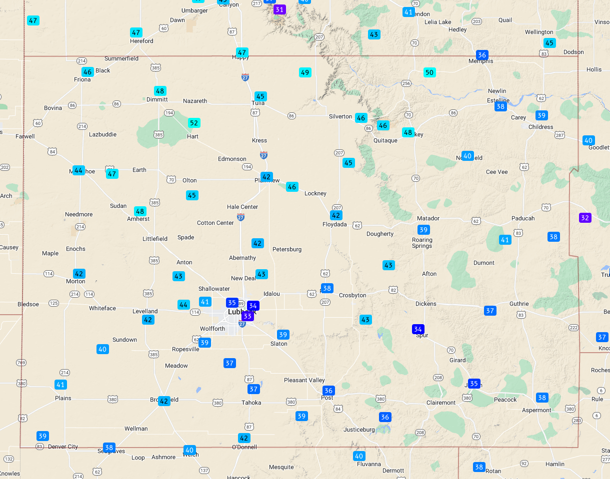
| The westerly wind gusts peaked at 50-60+ mph over most of the South Plains region, with the highest gusts favoring the southern Texas Panhandle, northern and western South Plains and northern Rolling Plains. Several locations measured peak gusts in excess of 60 mph, including a high gust of 64 mph sampled at the Lubbock Airport. | |||||
 |
|||||
| Plot of the peak wind gusts measured by the West Texas Mesonet (WTM) on 11 January 2023. The maximum sustained wind speeds measured by the WTM can be VIEWED HERE. | |||||
|
The intense westerly winds were mild/warm, by January standards, with highs reaching the 70s and 80s and many spots. The warm, dry and gusty winds raised the fire danger significantly through the afternoon hours. Preliminary wind reports from around the South Plains region for January 11th can be found below: |
|||||
PRELIMINARY LOCAL STORM REPORT...SUMMARY
NATIONAL WEATHER SERVICE LUBBOCK TX
732 PM CST WED JAN 11 2023

..TIME...   ...EVENT...      ...CITY LOCATION...     ...LAT.LON...
..DATE...   ....MAG....      ..COUNTY LOCATION..ST.. ...SOURCE....
            ..REMARKS..

0101 PM     NON-TSTM WND GST 2 NE DIMMITT            34.57N 102.29W
01/11/2023  M60 MPH          CASTRO             TX   MESONET

            WEST TEXAS MESONET

0150 PM     NON-TSTM WND GST 2 NE FRIONA             34.65N 102.69W
01/11/2023  M58 MPH          PARMER             TX   MESONET

            WEST TEXAS MESONET

0242 PM     NON-TSTM WND GST 3 N HART                34.42N 102.11W
01/11/2023  M58 MPH          CASTRO             TX   MESONET

            WEST TEXAS MESONET

0245 PM     NON-TSTM WND GST 7 ESE SILVERTON         34.45N 101.19W
01/11/2023  M58 MPH          BRISCOE            TX   MESONET

            WEST TEXAS MESONET

0301 PM     NON-TSTM WND GST 6 S OLTON               34.09N 102.12W
01/11/2023  M58 MPH          LAMB               TX   MESONET

            WEST TEXAS MESONET

0301 PM     NON-TSTM WND GST 1 S PLAINVIEW           34.18N 101.71W
01/11/2023  M58 MPH          HALE               TX   MESONET

            WEST TEXAS MESONET

0305 PM     NON-TSTM WND GST 2 NE DIMMITT            34.57N 102.29W
01/11/2023  M58 MPH          CASTRO             TX   MESONET

            WEST TEXAS MESONET

0309 PM     NON-TSTM WND GST 3 N HART                34.42N 102.11W
01/11/2023  M61 MPH          CASTRO             TX   MESONET

            ALSO GUSTED TO 59 MPH AT 310 PM. WEST TEXAS MESONET.

0310 PM     NON-TSTM WND GST 2 NE FRIONA             34.65N 102.69W
01/11/2023  M59 MPH          PARMER             TX   MESONET

            WEST TEXAS MESONET

0316 PM     NON-TSTM WND GST 2 NE FRIONA             34.65N 102.69W
01/11/2023  M60 MPH          PARMER             TX   MESONET

            ALSO GUSTED TO 58 MPH AT 323 PM. WEST TEXAS MESONET

0316 PM     NON-TSTM WND GST 2 W CHILDRESS           34.43N 100.28W
01/11/2023  M61 MPH          CHILDRESS          TX   ASOS

            ALSO GUSTED TO 59 MPH AT 306 PM. CHILDRESS AIRPORT
            ASOS.

0316 PM     NON-TSTM WND GST 2 W CHILDRESS           34.43N 100.28W
01/11/2023  M61 MPH          CHILDRESS          TX   ASOS

            CHILDRESS AIRPORT ASOS.

0322 PM     NON-TSTM WND GST VIGO PARK               34.65N 101.50W
01/11/2023  M58 MPH          SWISHER            TX   MESONET

            WEST TEXAS MESONET

0323 PM     NON-TSTM WND GST 1 NE AMHERST            34.02N 102.40W
01/11/2023  M59 MPH          LAMB               TX   MESONET

            WEST TEXAS MESONET

0328 PM     NON-TSTM WND GST 7 ESE SILVERTON         34.45N 101.19W
01/11/2023  M62 MPH          BRISCOE            TX   MESONET

            WEST TEXAS MESONET

0332 PM     NON-TSTM WND GST 2 NE DIMMITT            34.57N 102.29W
01/11/2023  M59 MPH          CASTRO             TX   MESONET

            WEST TEXAS MESONET

0335 PM     NON-TSTM WND GST 2 ENE TULIA             34.54N 101.74W
01/11/2023  M59 MPH          SWISHER            TX   MESONET

            ALSO GUSTED TO 58 MPH AT 318 PM. WEST TEXAS MESONET

0336 PM     NON-TSTM WND GST 2 NE FRIONA             34.65N 102.69W
01/11/2023  M59 MPH          PARMER             TX   MESONET

            WEST TEXAS MESONET

0340 PM     NON-TSTM WND GST 1 NE AMHERST            34.02N 102.40W
01/11/2023  M62 MPH          LAMB               TX   MESONET

            WEST TEXAS MESONET

0345 PM     NON-TSTM WND GST 7 ESE SILVERTON         34.45N 101.19W
01/11/2023  M58 MPH          BRISCOE            TX   MESONET

            ALSO GUSTED TO 58 MPH AT 338 PM AND 344 PM. WEST TEXAS
            MESONET.

0347 PM     NON-TSTM WND GST 1 S PLAINVIEW           34.18N 101.71W
01/11/2023  M59 MPH          HALE               TX   MESONET

            WEST TEXAS MESONET

0350 PM     NON-TSTM WND GST 1 NE MEMPHIS            34.73N 100.53W
01/11/2023  M60 MPH          HALL               TX   MESONET

            WEST TEXAS MESONET

0411 PM     NON-TSTM WND GST 2 WSW TURKEY            34.38N 100.93W
01/11/2023  M62 MPH          HALL               TX   MESONET

            ALSO GUSTED TO 58 MPH AT 409 PM AND 414 PM. WEST TEXAS
            MESONET

0437 PM     NON-TSTM WND GST 6 NNE LUBBOCK           33.67N 101.82W
01/11/2023  M64 MPH          LUBBOCK            TX   ASOS

            LUBBOCK AIRPORT ASOS

0540 PM     NON-TSTM WND GST 10 SW PADUCAH           33.89N 100.40W
01/11/2023  M58 MPH          COTTLE             TX   MESONET

            WEST TEXAS MESONET
|
|||||

