
Scattered thunderstorms with severe gusts, hail and a tornado risk are possible near a cold front from the Ohio Valley to the Mid-Atlantic tonight. Tropical Storm Bertha is expected to bring tropical storm conditions to portions of the Gulf Coast from the panhandle of Florida into Louisiana through Wednesday. Read More >
|
Wind for all, tumbleweeds for many, blizzard for a few |
|
 |
|
|
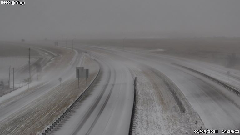
I-40 near Vega, TX, at 2:16 pm on Monday (8 January 2024). The image is courtesy of TXDOT. |
|
|
A powerful storm system emerging over the southern High Plains brought a variety of impacts to the region on Monday, January 8th. On the "warm" side of the system, showers and thunderstorms developed, while the cold side brought snow, while anyone near the system experienced an overabundance of wind. |
|
 |
|
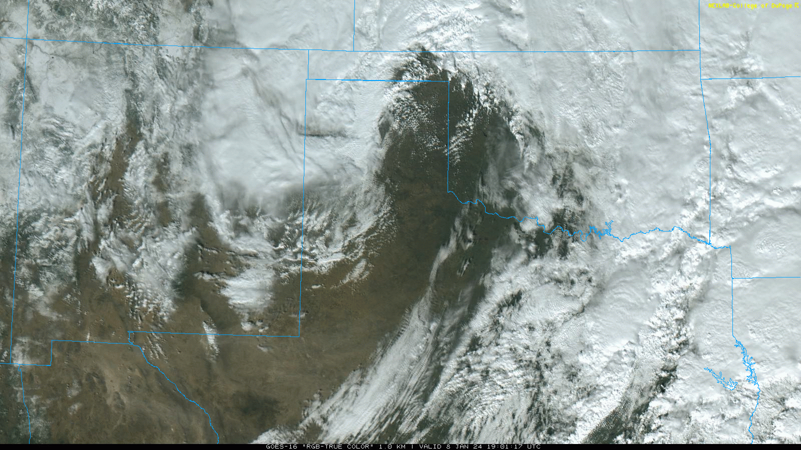
| RBG "True Color" satellite loop valid from 1:06 pm to 3:11 pm on Monday (8 January 2024). | |
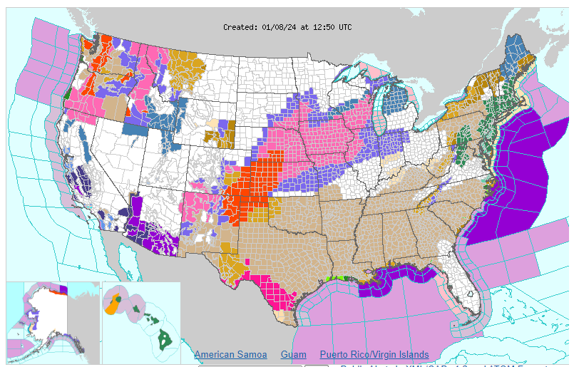
| As the below map shows, the weather impacts were not limited to West Texas. In fact, snow and wind affected a good portion of the center of the nation, while strong to severe wind gusts were felt across the entire central and southeastern United States. | |
 |
|
| Watch, Warning and Advisory map for the continuous U.S., valid at 7 am on 8 January 2024. | |
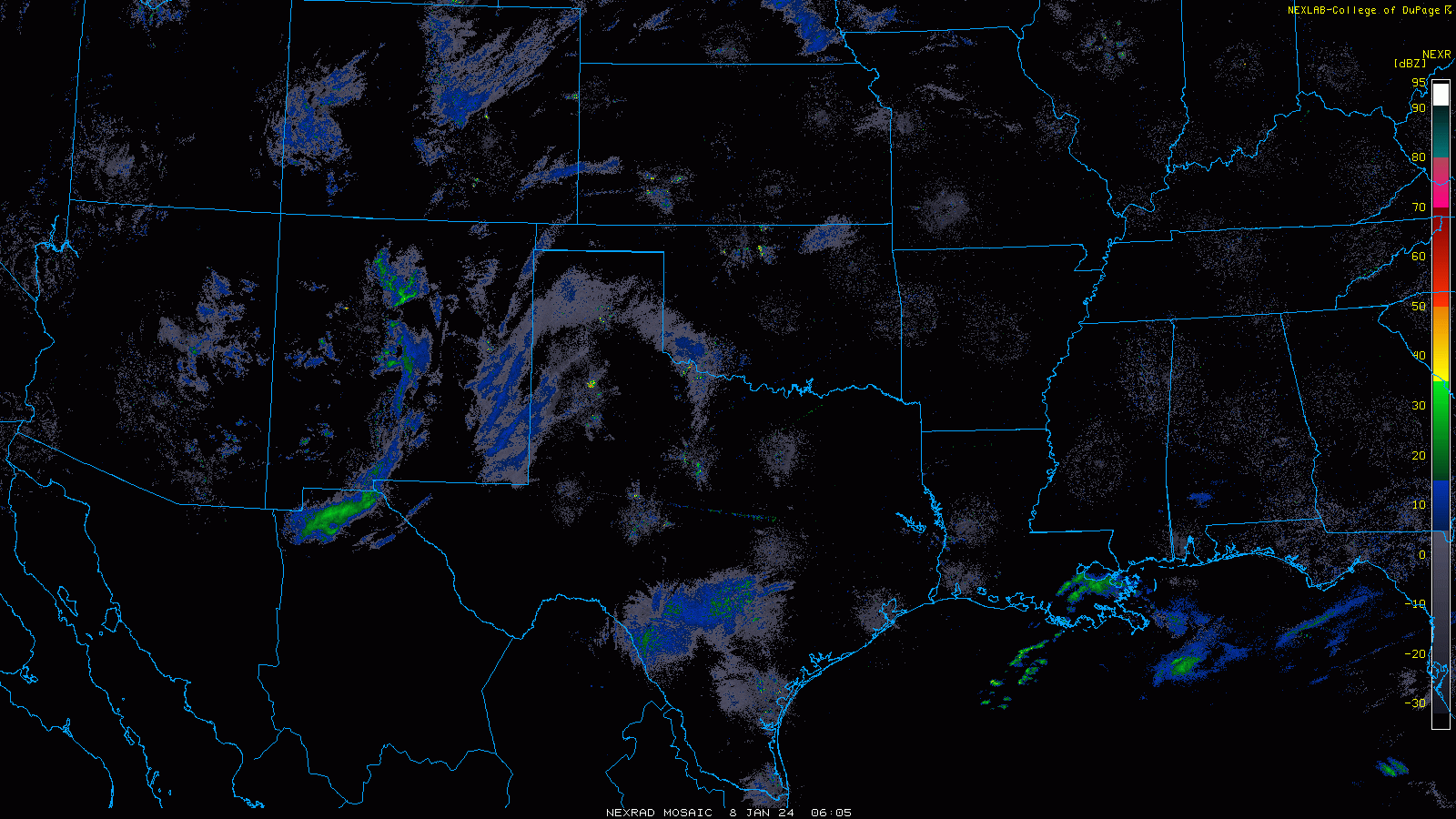
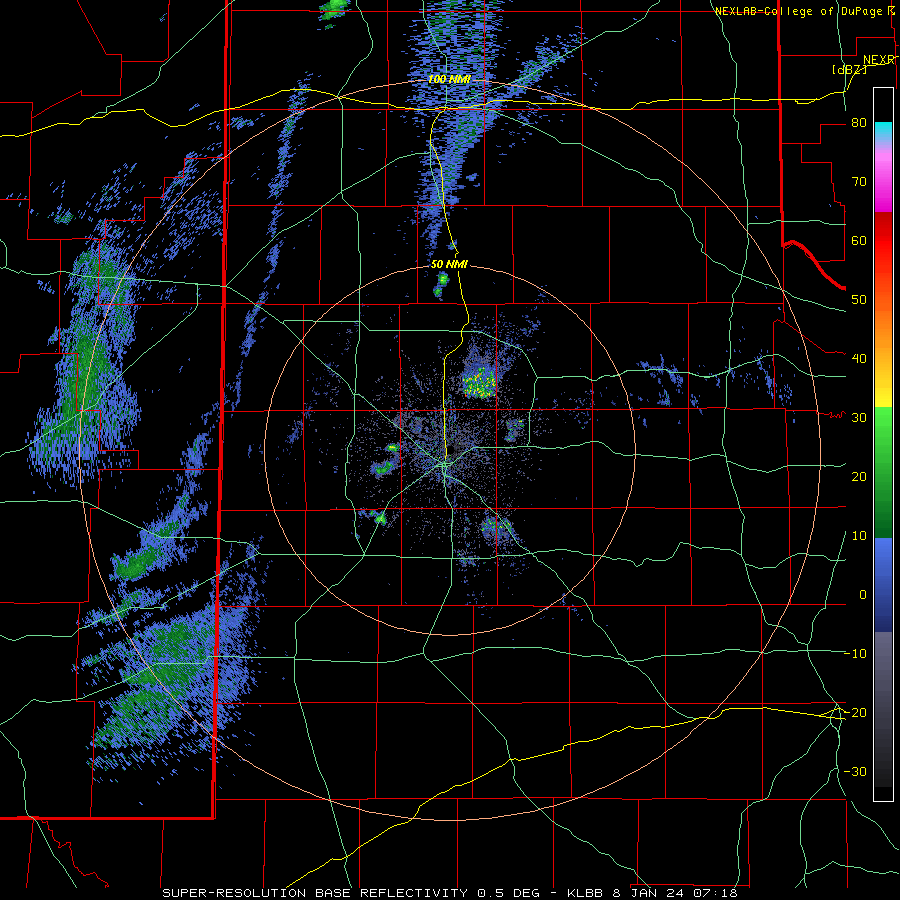
| The below radar animation nicely illustrates the intensification of the storm system as it began to ingest moisture from the Gulf. Precipitation rapidly increased in both coverage and intensity as showers and thunderstorms erupted over parts of Texas and Oklahoma. Some of this moisture was gradually transported westward, then southward, bring moderate to heavy snow on the backside (west side) of the storm system. | |
 |
|
| Regional radar animation valid from 12:05 am to 2:15 pm on Monday (8 January 2024). | |
| Even where spots missed out on the precipitation, nobody was immune to the intense winds. The strong winds first cranked up from the south on Sunday (7 January), well in advance of the storm system, but became even more intense as they shifted to the west and then northwest as the center of the system moved across the Texas Panhandle on Monday. | |
 |
|
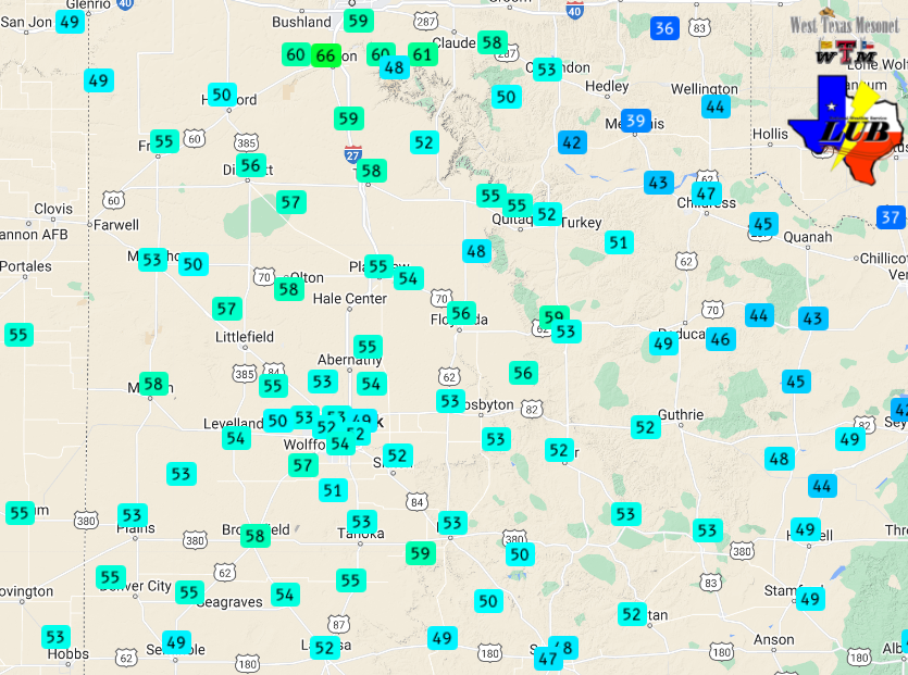
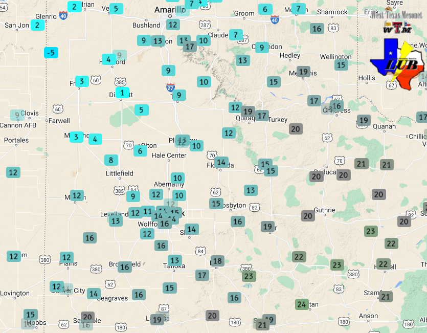
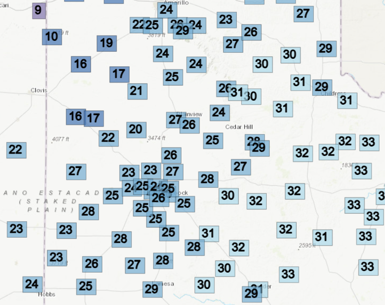
| Maximum wind gusts measured through 3:30 pm on Monday (8 January 2024). The data are courtesy of the West Texas Mesonet. | |
| Wind gusts of 50 to 60+ mph were common across northwest Texas Monday into Monday evening, before finally easing on Tuesday. In addition to fueling the precipitation, the wind lofted plenty of blowing dust, transported tumbleweeds across the open countryside and created whiteout conditions where the heavy snow fell. | |
 |
|
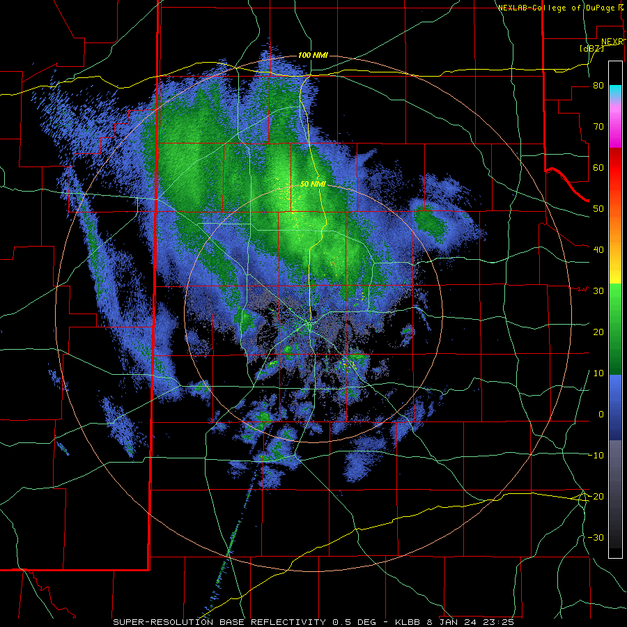
| Lubbock WSR-88D radar animation valid from 1:11 am to 6:19 am on Monday (8 January 2024). | |
|
Before any snow visited the South Plains region, scattered showers and thunderstorms formed over the central and eastern South Plains and swept eastward through the predawn hours of Monday. Dry conditions and increasing westerly winds followed Monday morning. |
|
 |
|
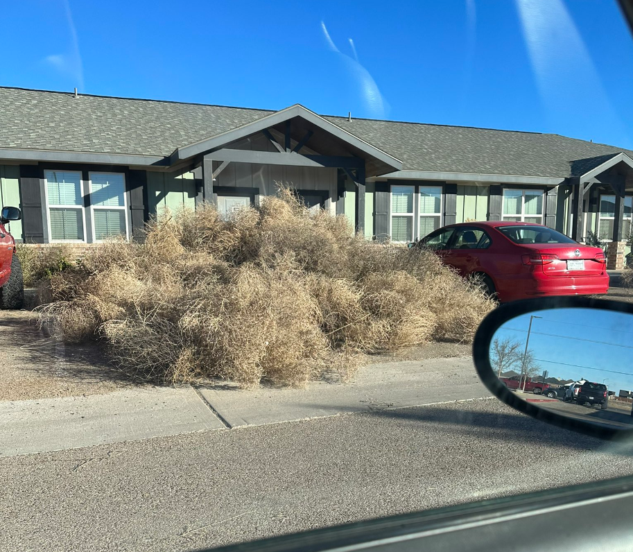
| Tumbleweeds gathered near a residence in Lubbock (9 January 2024). The picture is courtesy of Nathan Newman via X. | |
| The robust winds spurred on an impressive tumbleweed migration on Monday, adding to travel difficulties and pilling up where they encountered barriers like fences and buildings. | |
 |
|
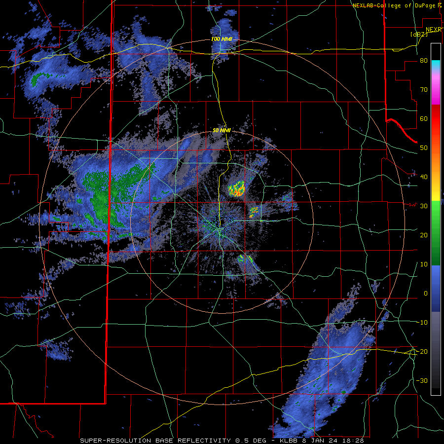
| Lubbock WSR-88D radar animation valid from 12:28 pm to 6:40 pm on Monday (8 January 2024). An additional radar animation, valid from 5:25 pm to 7:36 pm, can be VIEWED HERE. | |
|
The winds then turned northwestward, which carried in colder air and brought moisture, in the form of snow, southeastward over the western and central Texas Panhandle Monday afternoon and evening. |
|
 |
 |
 |
|
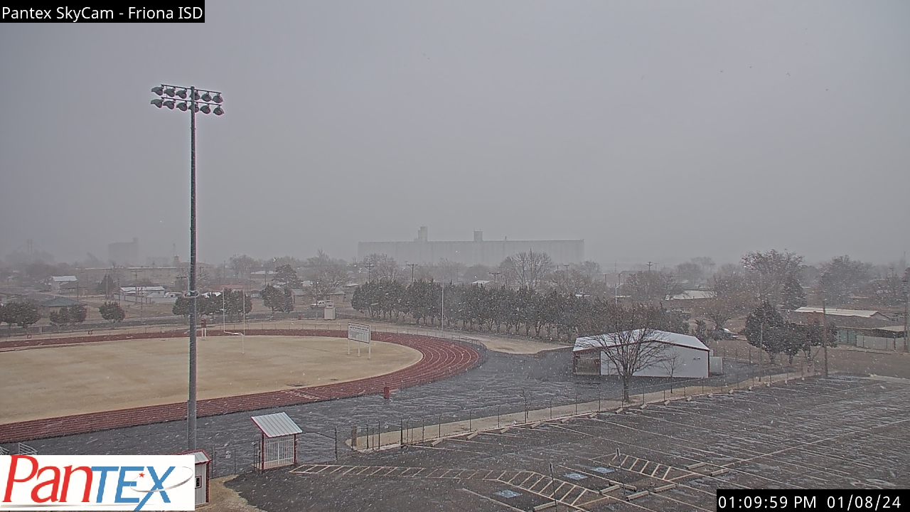
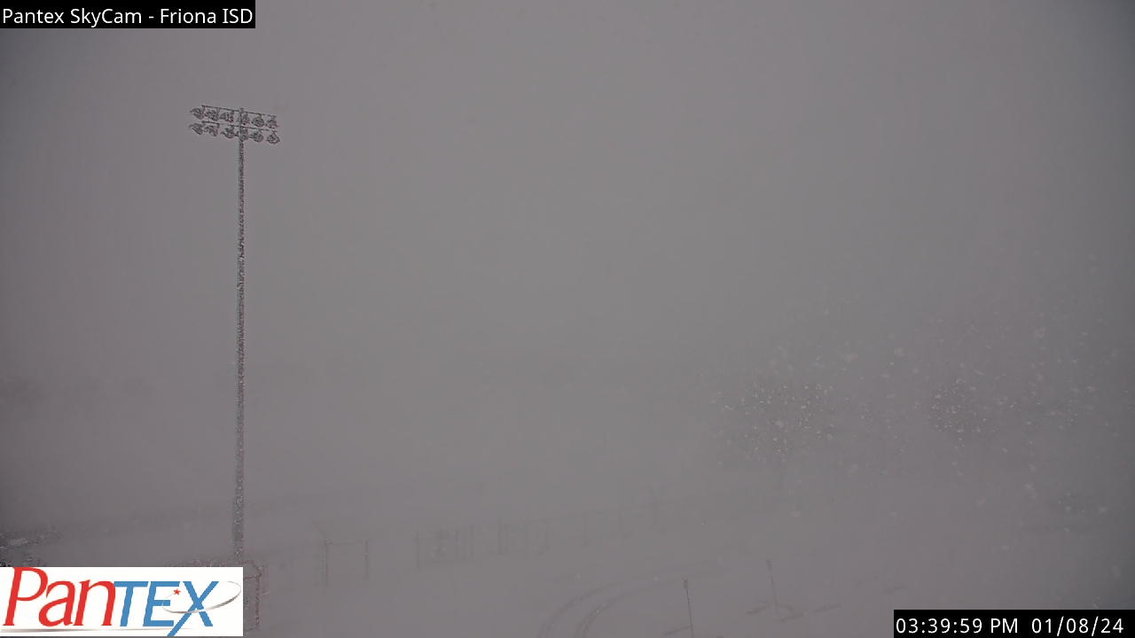
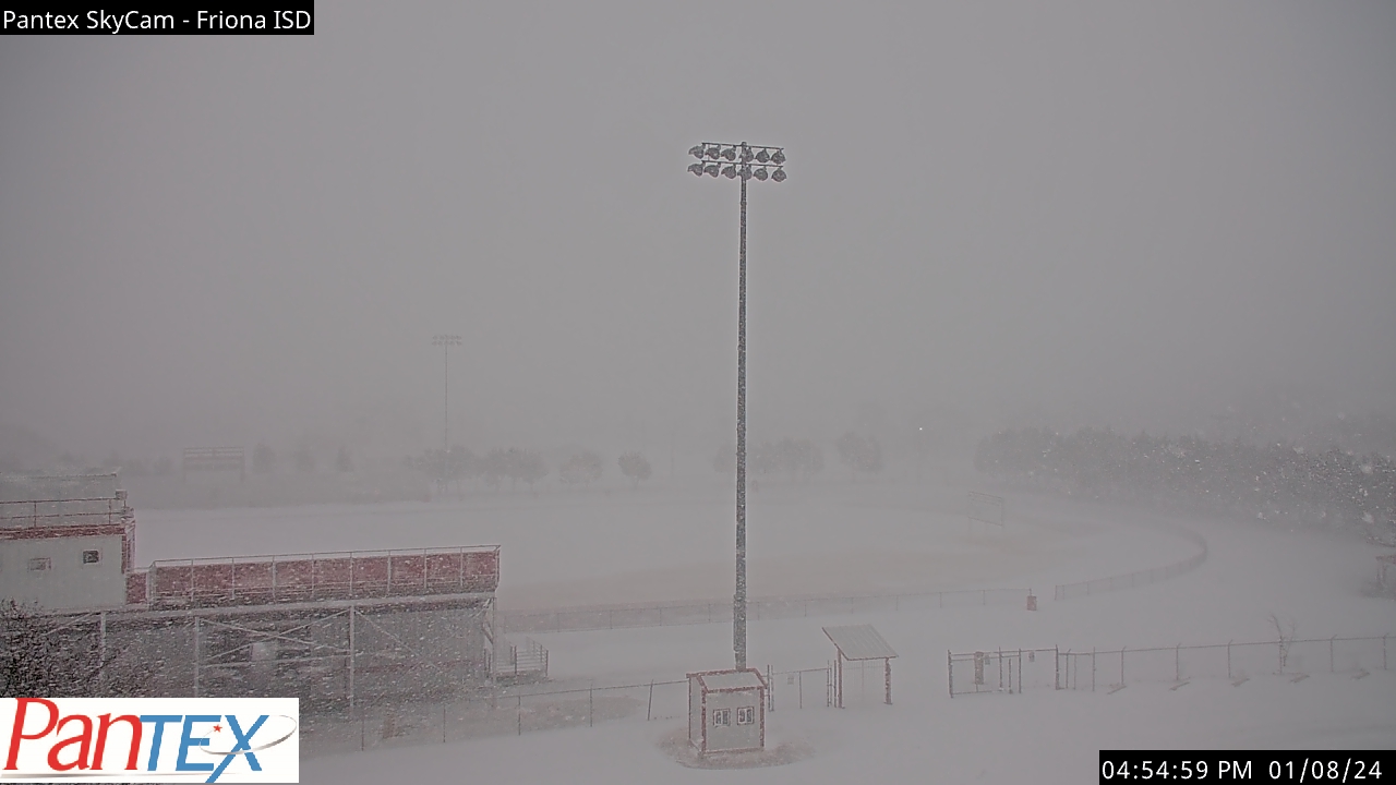
| View from Friona during Monday afternoon (8 January) and evening, courtesy of Pantex. The pictures were captured at: 1:10 pm (upper left); 3:40 pm (upper right); 4:55 pm (lower left); and 6:10 pm (lower right). | |
| The heaviest bands of snow were focused across the southwest Texas Panhandle, where 60+ mph wind gusts created near zero visibility in whiteout conditions. Locations in and around Friona and Dimmitt were particularly hard hit, and several roadways, including Highway 385 north of Dimmitt, were closed during the height of the storm. The dangerous travel conditions resulted in numerous vehicles running off the road and becoming stranded in the ditch. | |
 |
|
| Wind chill values at 6:10 am on Tuesday (9 January 2024). The data are courtesy of the West Texas Mesonet. To view the temperatures at 6:10 am CLICK HERE. | |
| Temperatures tumbled into the teens and 20s in the wake of the system early Tuesday, which when coupled with breezy winds, resulted in wind chills in the single digits and teens in many spots. | |
 |
|
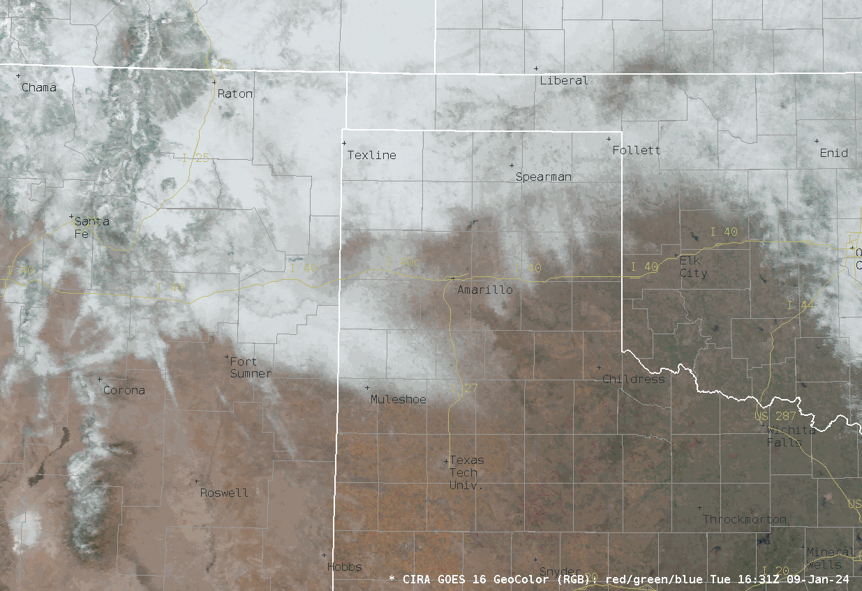
| GeoColor satellite loop valid Tuesday morning (9 January 2024). | |
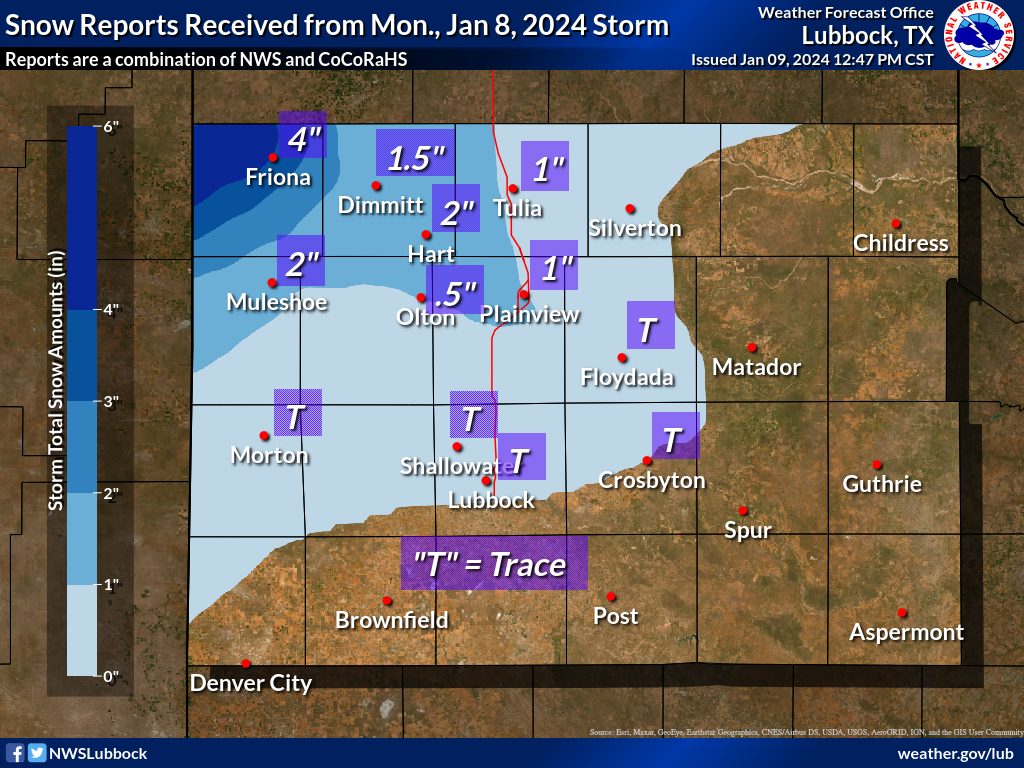
| In total, 2 to 4 inches of snow was measured over much of Parmer and Castro Counties, with around 1 inch of snow in Tulia and Plainview. Even where the snow was on the lighter side, roadways became slick due to the snow (and ice) from near Plainview, and then many locations north and west from there. Although travel wasn't affected significantly further south, including in Lubbock, a few brief snow squalls were witnessed Monday afternoon and evening. | |
 |
|
| Snow totals collected from Monday (8 January 2024). | |
| Wind and snow reports collected from this impactful weather day can found below: | |
Preliminary Local Storm Report...Summary
National Weather Service Lubbock TX
1045 AM CST Tue Jan 9 2024

..TIME...   ...EVENT...      ...CITY LOCATION...     ...LAT.LON...
..DATE...   ....MAG....      ..COUNTY LOCATION..ST.. ...SOURCE....
            ..REMARKS..

1224 PM     Non-Tstm Wnd Gst 1 ENE Morton            33.73N 102.74W
01/08/2024  M58 MPH          Cochran            TX   Mesonet

            West Texas Mesonet. Sustained winds as high
            as 44 mph also measured within the last
            hour.

1239 PM     Non-Tstm Wnd Gst 2 S Brownfield          33.15N 102.27W
01/08/2024  M58 MPH          Terry              TX   Mesonet

            West Texas Mesonet. 46 mph sustained wind
            also measured.

0150 PM     Non-Tstm Wnd Gst Lubbock Int. Airport    33.67N 101.82W
01/08/2024  M58 MPH          Lubbock            TX   ASOS


0301 PM     Non-Tstm Wnd Gst 6 S Olton               34.09N 102.12W
01/08/2024  M58 MPH          Lamb               TX   Mesonet

            West Texas Mesonet. 47 mph sustained wind
            also measured.

0328 PM     Non-Tstm Wnd Gst 4 WSW Matador           33.99N 100.88W
01/08/2024  M59 MPH          Motley             TX   Mesonet

            West Texas Mesonet. Additional gust to 59
            mph measured at 3:40 pm.

0335 PM     Non-Tstm Wnd Gst 1 E Happy               34.74N 101.84W
01/08/2024  M63 MPH          Swisher            TX   Mesonet

            West Texas Mesonet. Additional gusts ranging
            from 59 to 61 mph measured from 3:24 pm to
            3:41 pm.

0346 PM     Non-Tstm Wnd Gst 2 ENE Tulia             34.54N 101.74W
01/08/2024  M64 MPH          Swisher            TX   Mesonet

            West Texas Mesonet. Additional gusts to 58
            mph also measured between 3:12 pm and 3:53
            pm.

0348 PM     Non-Tstm Wnd Gst 7 ESE Silverton         34.45N 101.19W
01/08/2024  M58 MPH          Briscoe            TX   Mesonet

            West Texas Mesonet.

0350 PM     Non-Tstm Wnd Gst 3 N Roaring Springs     33.94N 100.85W
01/08/2024  M59 MPH          Motley             TX   Mesonet

            West Texas Mesonet.

0354 PM     Non-Tstm Wnd Gst 3 NNW Mcadoo            33.77N 101.04W
01/08/2024  M59 MPH          Dickens            TX   Mesonet

            West Texas Mesonet. Additional gusts of 58
            to 59 mph occurred until 4:02 pm.

0422 PM     Non-Tstm Wnd Gst 4 WSW Matador           33.99N 100.88W
01/08/2024  M60 MPH          Motley             TX   Mesonet

            West Texas Mesonet.

0428 PM     Non-Tstm Wnd Gst 2 NE Slaton             33.46N 101.62W
01/08/2024  M61 MPH          Lubbock            TX   Mesonet

            West Texas Mesonet.

0431 PM     Non-Tstm Wnd Gst 6 NW White River Lake   33.53N 101.17W
01/08/2024  M62 MPH          Crosby             TX   Mesonet

            West Texas Mesonet. Additional gusts ranging
            from 58 mph to 61 mph measured from 4:16 pm
            to 4:40 pm.

0436 PM     Non-Tstm Wnd Gst Caprock Canyons State P 34.41N 101.07W
01/08/2024  M58 MPH          Briscoe            TX   Mesonet

            West Texas Mesonet.

0447 PM     Non-Tstm Wnd Gst 2 WSW Turkey            34.38N 100.93W
01/08/2024  M61 MPH          Hall               TX   Mesonet

            West Texas Mesonet. Additional gusts of 58
            to 59 mph measured between 4:23 pm and 4:57
            pm.

0450 PM     Non-Tstm Wnd Gst 4 NNE Shallowater       33.74N 101.97W
01/08/2024  M61 MPH          Lubbock            TX   Mesonet

            West Texas Mesonet.

0456 PM     Non-Tstm Wnd Gst 1 S Northfield          34.27N 100.60W
01/08/2024  M58 MPH          Motley             TX   Mesonet

            West Texas Mesonet.

0458 PM     Non-Tstm Wnd Gst 1 NE Memphis            34.73N 100.53W
01/08/2024  M64 MPH          Hall               TX   Mesonet

            West Texas Mesonet. Additional gusts ranging
            from 58 mph to 61 mph measured between 4:22
            pm and 5:05 pm.

0507 PM     Non-Tstm Wnd Gst 2 S Lesley              34.65N 100.81W
01/08/2024  M58 MPH          Hall               TX   Mesonet

            Measured by the TTU West Texas mesonet.

0508 PM     Non-Tstm Wnd Gst 4 W Childress           34.43N 100.28W
01/08/2024  M61 MPH          Childress          TX   ASOS


0509 PM     Non-Tstm Wnd Gst 3 NNW Mcadoo            33.77N 101.04W
01/08/2024  M65 MPH          Dickens            TX   Mesonet

            West Texas Mesonet. Additional gusts ranging
            from 58 mph to 62 mph measured from 4:52 pm
            to 5:10 pm.

0516 PM     Non-Tstm Wnd Gst Lubbock Int. Airport    33.67N 101.82W
01/08/2024  M68 MPH          Lubbock            TX   ASOS

            Additional gusts ranging from 58 mph to 64
            mph measured from 4:11 pm until 4:56 pm.

0542 PM     Non-Tstm Wnd Gst 2 S Lesley              34.65N 100.81W
01/08/2024  M61 MPH          Hall               TX   Mesonet


0550 PM     Non-Tstm Wnd Gst Northfield              34.29N 100.60W
01/08/2024  M63 MPH          Motley             TX   Mesonet


0550 PM     Non-Tstm Wnd Gst 1 S Northfield          34.27N 100.60W
01/08/2024  M63 MPH          Motley             TX   Mesonet


0556 PM     Non-Tstm Wnd Gst 7 ESE Silverton         34.45N 101.19W
01/08/2024  M62 MPH          Briscoe            TX   Mesonet


0558 PM     Non-Tstm Wnd Gst O`Donnell               32.97N 101.83W
01/08/2024  M60 MPH          Lynn               TX   Mesonet


0613 PM     Non-Tstm Wnd Gst Paducah                 34.01N 100.30W
01/08/2024  M58 MPH          Cottle             TX   Mesonet


0646 PM     Non-Tstm Wnd Gst 4 WSW Matador           34.00N 100.89W
01/08/2024  M62 MPH          Motley             TX   Mesonet


0709 PM     Non-Tstm Wnd Gst 2 S Caprock Canyons Sta 34.41N 101.07W
01/08/2024  M65 MPH          Briscoe            TX   Mesonet


0801 PM     Non-Tstm Wnd Gst Floydada                33.98N 101.34W
01/08/2024  M59 MPH          Floyd              TX   Mesonet


0803 PM     Non-Tstm Wnd Gst 4 W Childress           34.43N 100.28W
01/08/2024  M68 MPH          Childress          TX   ASOS


0811 PM     Non-Tstm Wnd Gst 10 SW Paducah           33.89N 100.40W
01/08/2024  M62 MPH          Cottle             TX   Mesonet


0841 PM     Non-Tstm Wnd Gst New Deal                33.73N 101.84W
01/08/2024  M60 MPH          Lubbock            TX   Mesonet


0849 PM     Non-Tstm Wnd Gst 2 NNE Childress         34.46N 100.20W
01/08/2024  M66 MPH          Childress          TX   Mesonet

            Mesonet station 50 Childress 2NNE.

1052 PM     Non-Tstm Wnd Gst 3 NNE Roaring Springs   33.94N 100.85W
01/08/2024  M62 MPH          Motley             TX   Mesonet

            Mesonet station 7 Roaring Springs 3N.

1103 PM     Non-Tstm Wnd Gst 5 NW White River Lake   33.53N 101.17W
01/08/2024  M65 MPH          Crosby             TX   Mesonet

            Mesonet station 27 White River Lake 6NW.

0319 AM     Non-Tstm Wnd Gst 2 S Caprock Canyons Sta 34.41N 101.07W
01/09/2024  M60 MPH          Briscoe            TX   Mesonet

            Mesonet station 61 Caprock Canyons
            SP/Briscoe.

