
Dangerous and extreme heat will remain across portions of the central U.S. this week, persisting across the mid to lower Mississippi Valley, Gulf Coast, southern Plains and portions of Texas. A heat wave over the Southwest U.S. will peak this weekend. Heavy to excessive rainfall may produce flash flooding from the Delmarva Peninsula north into the Hudson Valley today and tonight. Read More >
|
Wind, dust and wildfires |
|
 |
|
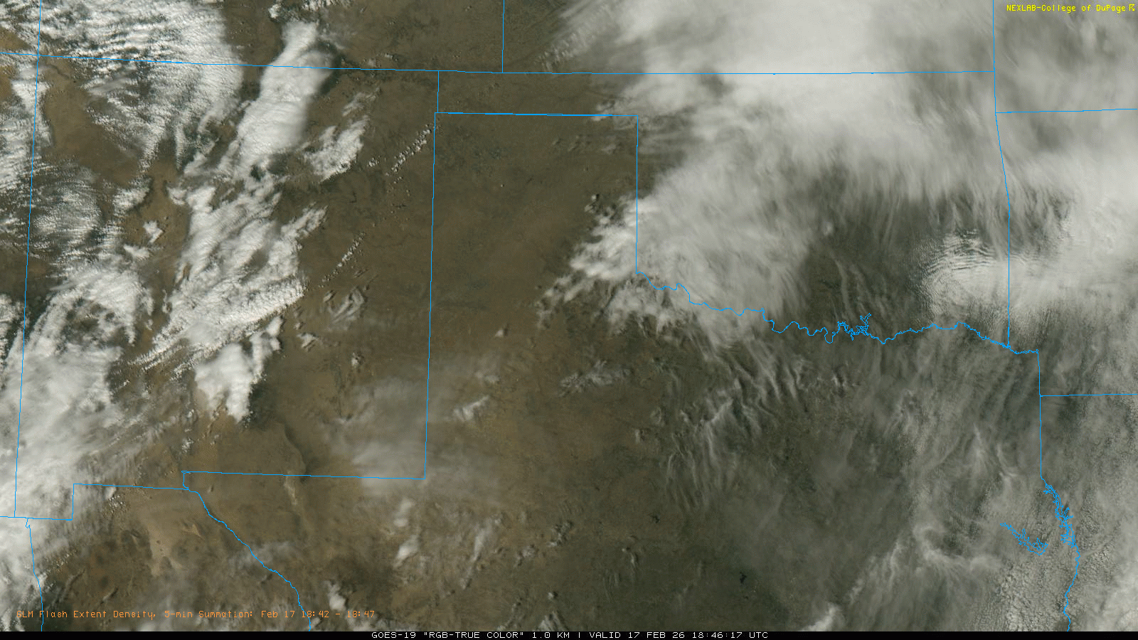
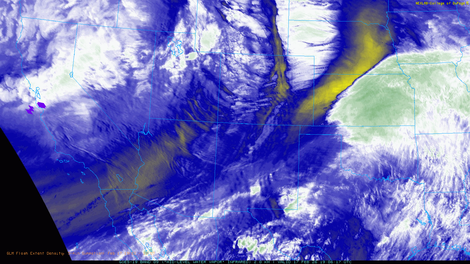
| "RGB True Color" satellite animation valid from 12:51 pm to 5:46 pm on Tuesday (17 February 2026). A regional water vapor satellite animation, valid from 1:06 pm to 5:46 pm on Tuesday, can be FOUND HERE. | |
|
An expansive and energetic storm system spreading eastward from the Intermountain West brought widespread impacts to the center of the nation in mid-February. This system, which brought flooding rains and feet of mountain snows to portions of California, provided snow to the central and southern Rockies. However, the more widespread impact was the strong winds and resulting blowing dust and critical fire weather that affected much of the central and southern High Plains. |
|
 |
|
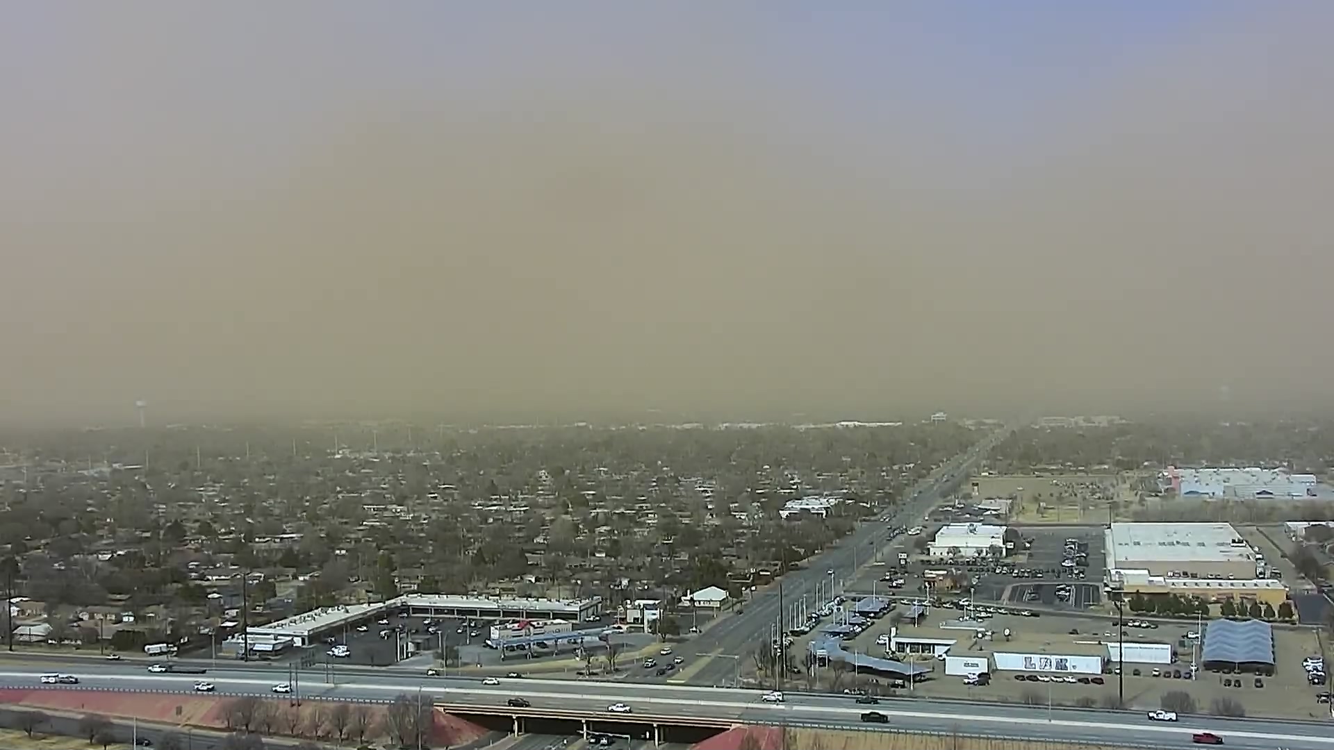
| Dusty skyline from South Lubbock on Tuesday afternoon (17 February). The image is courtesy of KAMC and was taken around 2 pm. | |
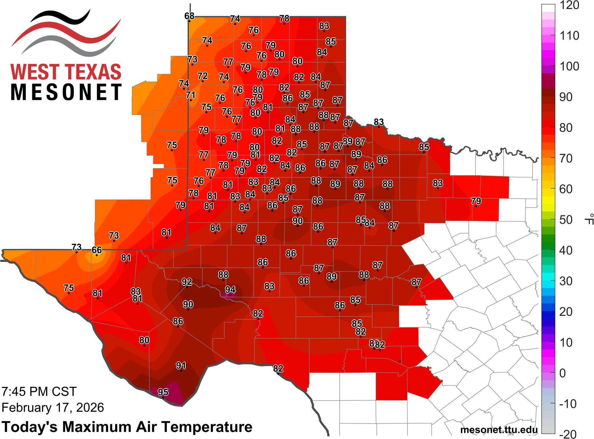
| Specifically, intense westerly winds throughout the depth of the atmosphere, racing through the south side of the mid-upper level trough, spread across the southern High Plains on Tuesday (17 February). These downslope winds caused temperatures to soar into the 70s and 80s, while moisture levels plunged. | |
 |
|
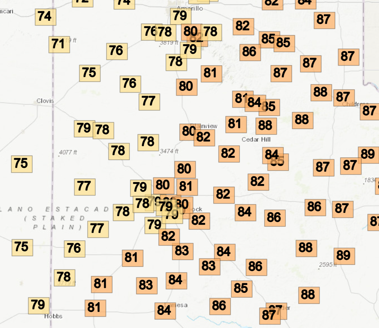
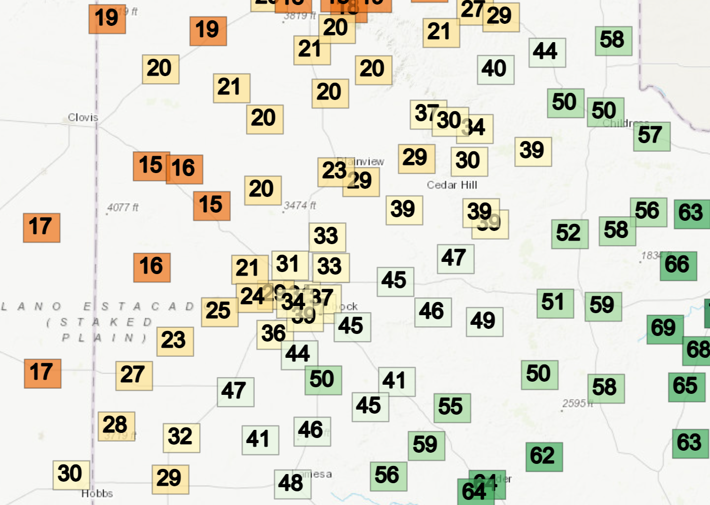
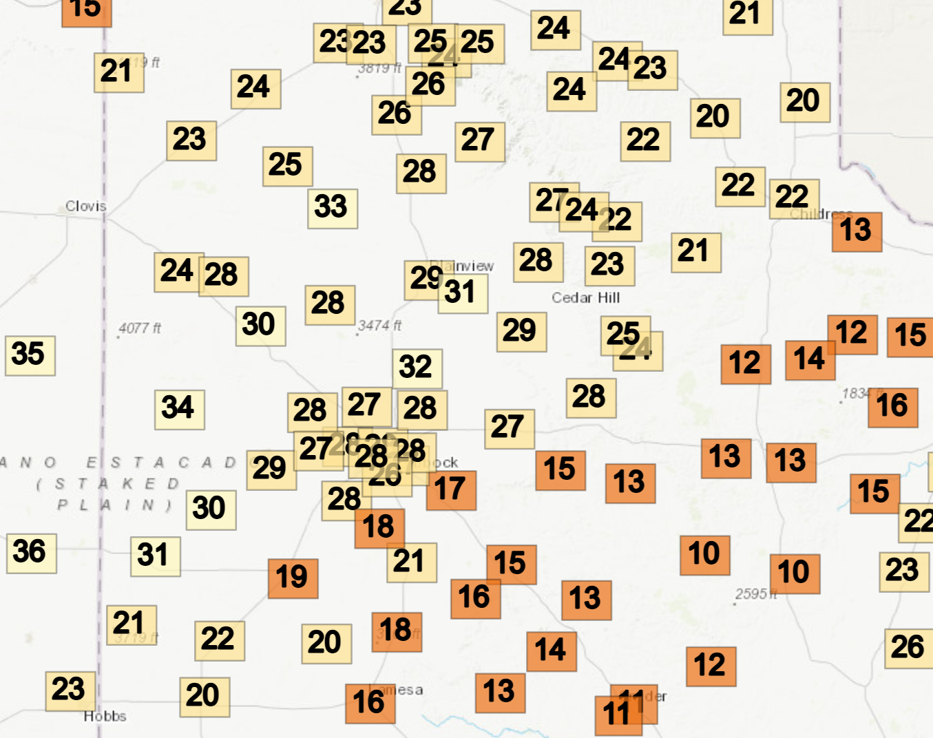
| Observed high temperatures on Tuesday (17 February 2026). The data are courtesy of the West Texas Mesonet (WTM). A regional view of the same information can be VIEWED HERE. | |
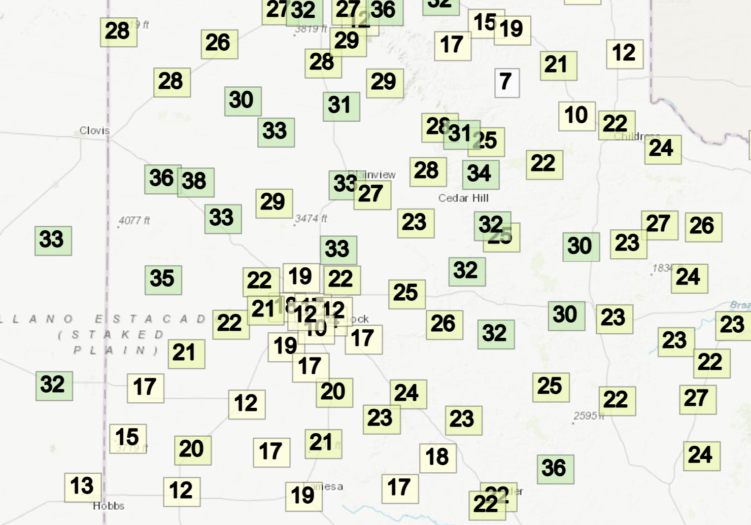
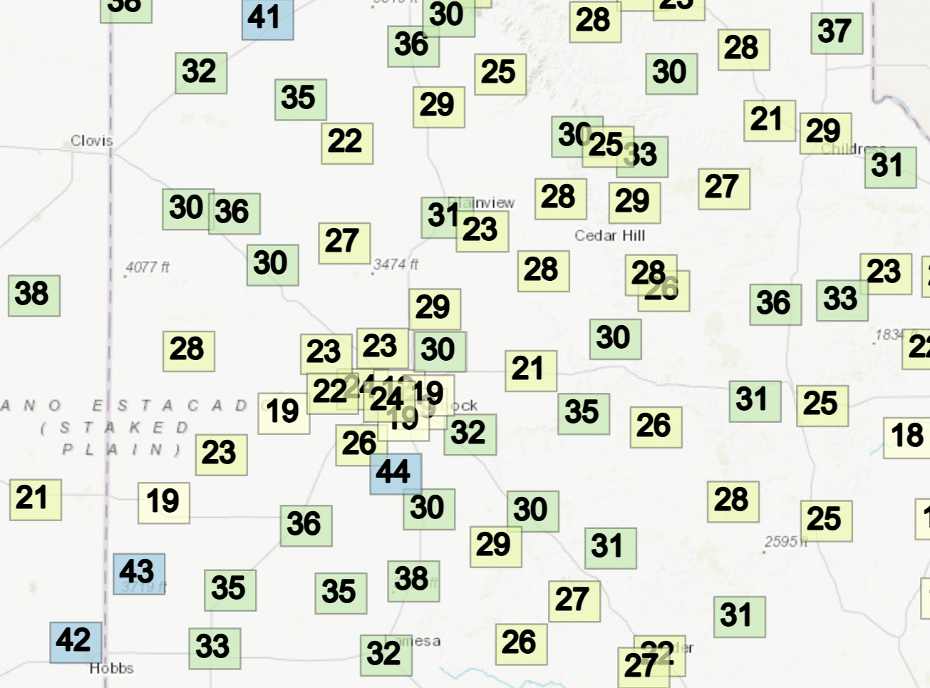
| Westerly winds, gusting from 20 to 40 mph, were common across the South Plains region by mid-late Tuesday morning. At the same time, drier air moving in out of eastern New Mexico caused the relative humidity (RH) to tumble into the teens. | |
 |
 |
| Wind gust (left) and relative humidity (right) at 10:30 am on Tuesday (17 February 2026). The data are courtesy of the WTM. | |
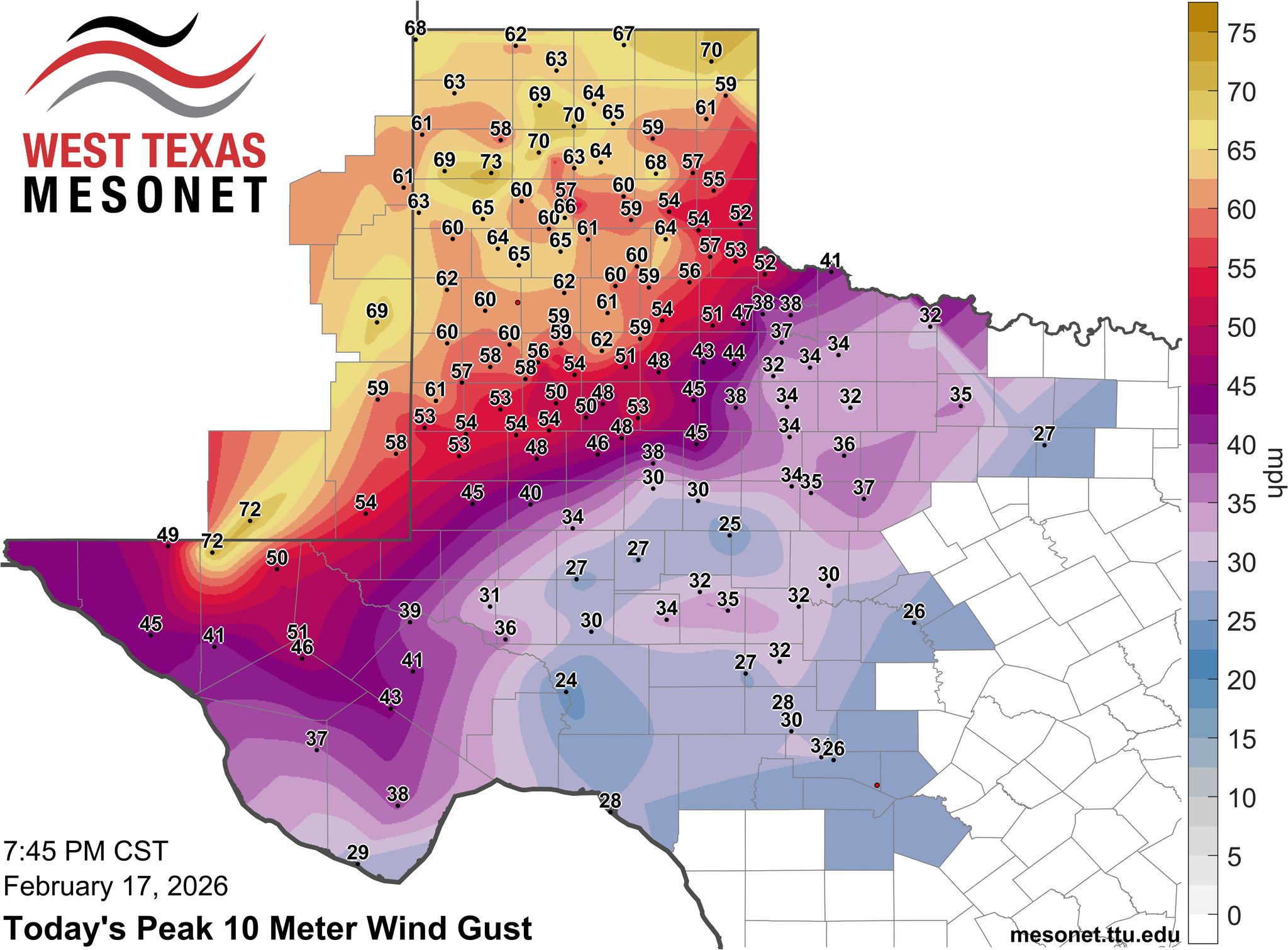
| Unfortunately, the winds continued to increase, peaking Tuesday afternoon. Many locations across the Caprock into the southeast Texas Panhandle recorded wind gusts near and in excess of 60 mph. This included a peak wind gust of 77 mph at the Olton West Texas Mesonet (WTM), 66 mph at the Happy WTM and 73 mph at the Lubbock Airport. | |
 |
|
| Peak wind gust measured by the WTM on Tuesday (17 February 2026). | |
| Farther south and east, from the Big Bend through the Big Country and North Texas, winds were much lighter, though still breezy at times. That said, the most intense corridor of winds stretched from southwest-to-northeast from the Guadalupe Mountains through southeast New Mexico and into the western and northern Texas Panhandle. | |
 |
|
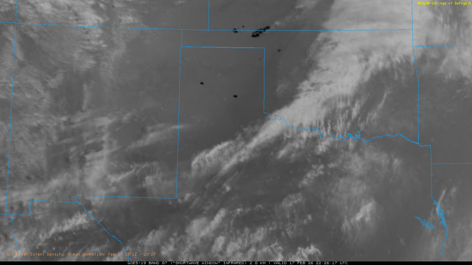
| "Shortwave Window" infrared satellite animation valid from 4:26 pm to 5:46 pm on Tuesday (17 February 2026). | |
| The powerful winds lofted copious amounts of blowing dust, which reduced the visibility significantly over much of Far West Texas, southeast New Mexico and the South Plains and Rolling Plains. The visibility at Lubbock officially dipped to 1 mile shortly before 2 pm and remained at or below 1 mile until just before 6 pm. The thick dust and strong winds made travel difficult, and being outside extremely unpleasant. | |
 |
 |
| Wind gust (left) and relative humidity (right) at 6:15 pm on Tuesday (17 February 2026). The data are courtesy of the WTM. | |
|
In addition, the warm and dry conditions, in combination with the dormant fuels and strong winds, were very favorable for dangerous and explosive wildfires where ignitions occurred. Several large wildfires did rapidly develop, primarily over the Texas and Oklahoma Panhandles, as well as northwest Oklahoma and southwest Kansas. Closer to home, several wildfires ignited over the South Plains and southern Texas Panhandle, including one that damaged or destroyed several structures in Seth Ward (near Plainview). |
|
 |
|
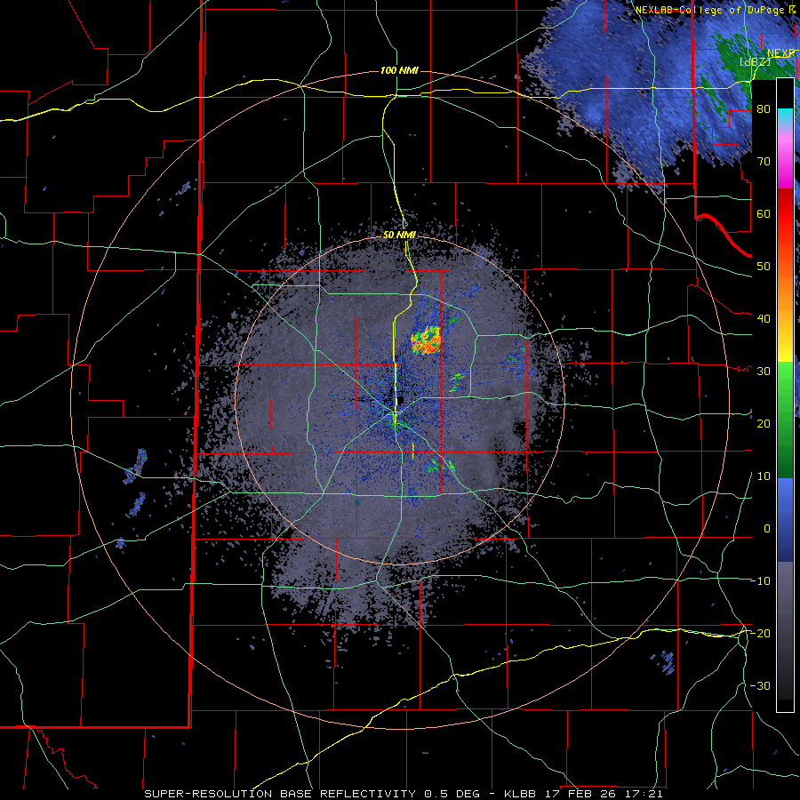
| Lubbock WSR-88D radar animation valid from 11:21 am to 5:47 pm on Tuesday (17 February 2026). | |
|
|
|
|
Smoke from the wildfires was visible in satellite imagery (seen at the top of this page), while the heat from the wildfires was also sensed by satellite (dark areas on the infrared imagery). Even the Lubbock radar (immediately above) sensed several plumes of smoke, as well as Pacific cold front as it swept through the region during the mid-late afternoon. Preliminary storm reports collected by WFO Lubbock for this wind event can be found below. |
|
Preliminary Local Storm Report...Summary
National Weather Service Lubbock TX
706 PM CST Tue Feb 17 2026

..TIME...   ...EVENT...      ...CITY LOCATION...     ...LAT.LON...
..DATE...   ....MAG....      ..COUNTY LOCATION..ST.. ...SOURCE....
            ..REMARKS..

1058 AM     Non-Tstm Wnd Gst 9 SW Earth              34.19N 102.56W
02/17/2026  M58 MPH          Lamb               TX   Mesonet

            Measured by the TTU mesonet.

1127 AM     Non-Tstm Wnd Gst 2 NE Dimmitt            34.57N 102.29W
02/17/2026  M58 MPH          Castro             TX   Mesonet

            Measured by the TTU mesonet.

1132 AM     Non-Tstm Wnd Gst 2 SSW Muleshoe          34.21N 102.74W
02/17/2026  M60 MPH          Bailey             TX   Mesonet

            Measured by the TTU mesonet.

1147 AM     Non-Tstm Wnd Gst 3 N Hart                34.42N 102.11W
02/17/2026  M61 MPH          Castro             TX   Mesonet

            Measured by the TTU mesonet.

1150 AM     Non-Tstm Wnd Gst 1 E Happy               34.74N 101.84W
02/17/2026  M59 MPH          Swisher            TX   Mesonet

            Measured by the TTU mesonet.

1156 AM     Non-Tstm Wnd Gst 1 ENE Morton            33.73N 102.74W
02/17/2026  M59 MPH          Cochran            TX   Mesonet

            Measured by the TTU mesonet.

1207 PM     Non-Tstm Wnd Gst 2 ENE Tulia             34.54N 101.74W
02/17/2026  M60 MPH          Swisher            TX   Mesonet

            Measured by the TTU mesonet.

1213 PM     Non-Tstm Wnd Gst Vigo Park               34.65N 101.50W
02/17/2026  M61 MPH          Swisher            TX   Mesonet

            Measured by the TTU mesonet.

1236 PM     Non-Tstm Wnd Gst 1 S Plainview           34.18N 101.71W
02/17/2026  M58 MPH          Hale               TX   Mesonet

            Measured by the TTU mesonet.

1259 PM     Non-Tstm Wnd Gst 1 NE Amherst            34.02N 102.40W
02/17/2026  M60 MPH          Lamb               TX   Mesonet

            Measured by the TTU mesonet.

0115 PM     Non-Tstm Wnd Gst 6 S Olton               34.09N 102.12W
02/17/2026  M58 MPH          Lamb               TX   Mesonet

            Measured by the TTU mesonet.

0124 PM     Non-Tstm Wnd Gst 6 SSW Anton             33.73N 102.19W
02/17/2026  M59 MPH          Hockley            TX   Mesonet

            Measured by the TTU mesonet.

0125 PM     Non-Tstm Wnd Gst 1 NNW Lubbock Int. Airp 33.67N 101.82W
02/17/2026  M67 MPH          Lubbock            TX   ASOS


0129 PM     Non-Tstm Wnd Gst 3 WSW Aiken             34.13N 101.57W
02/17/2026  M59 MPH          Hale               TX   Mesonet

            Measured by the TTU mesonet.

0130 PM     Non-Tstm Wnd Gst 2 SSE Plainview         34.17N 101.72W
02/17/2026  M58 MPH          Hale               TX   AWOS


0145 PM     Non-Tstm Wnd Gst 7 ESE Silverton         34.45N 101.19W
02/17/2026  M58 MPH          Briscoe            TX   Mesonet

            Measured by the TTU mesonet.


0151 PM     Wildfire         3 NNE Plainview         34.22N 101.70W
02/17/2026                   Hale               TX   Emergency Mngr

            Arbor Fire: 600 acres burned in and north of
            the community of Seth Ward. Total of 8
            structures destroyed. Several families
            displaced from their homes. No injuries.
            Fire began just before 2 PM on Feb. 17 and
            is 100% contained as of Feb. 18.


0158 PM     Non-Tstm Wnd Gst 2 S Lesley              34.65N 100.81W
02/17/2026  M63 MPH          Hall               TX   Mesonet

            Measured by the TTU mesonet.

0200 PM     Non-Tstm Wnd Gst 1 N Lubbock Int. Airpor 33.67N 101.82W
02/17/2026  M73 MPH          Lubbock            TX   ASOS

            Corrects previous gust report. ASOS station
            KLBB Lubbock.

0202 PM     Non-Tstm Wnd Gst Smyer                   33.59N 102.17W
02/17/2026  M59 MPH          Hockley            TX   Mesonet

            Measured by the TTU mesonet.

0203 PM     Non-Tstm Wnd Gst 3 ENE South Plains      34.24N 101.26W
02/17/2026  M58 MPH          Floyd              TX   Mesonet

            Measured by the TTU mesonet.

0216 PM     Non-Tstm Wnd Gst 2 WSW Turkey            34.38N 100.93W
02/17/2026  M60 MPH          Hall               TX   Mesonet

            Measured by the TTU mesonet.

0217 PM     Non-Tstm Wnd Gst Caprock Canyons State P 34.41N 101.07W
02/17/2026  M58 MPH          Briscoe            TX   Mesonet

            Measured by the TTU mesonet.

0220 PM     Non-Tstm Wnd Gst 2 NE Friona             34.65N 102.69W
02/17/2026  M60 MPH          Parmer             TX   Mesonet

            Measured by the TTU mesonet.

0220 PM     Non-Tstm Wnd Gst 6 ENE Abernathy         33.88N 101.76W
02/17/2026  M58 MPH          Hale               TX   Mesonet

            Measured by the TTU mesonet.

0224 PM     Non-Tstm Wnd Gst 4 NNE Shallowater       33.74N 101.97W
02/17/2026  M60 MPH          Lubbock            TX   Mesonet

            Measured by the TTU mesonet.

0228 PM     Non-Tstm Wnd Gst Reese Center            33.61N 102.05W
02/17/2026  M59 MPH          Lubbock            TX   Mesonet

            Measured by the TTU mesonet.

0229 PM     Non-Tstm Wnd Gst 2 WSW Turkey            34.38N 100.93W
02/17/2026  M59 MPH          Hall               TX   Mesonet

            Measured by the TTU mesonet.

0235 PM     Non-Tstm Wnd Gst 2 SSW Levelland         33.55N 102.37W
02/17/2026  M64 MPH          Hockley            TX   AWOS


0236 PM     Non-Tstm Wnd Gst 1 NNE Floydada          34.00N 101.33W
02/17/2026  M59 MPH          Floyd              TX   Mesonet

            Measured by the TTU mesonet.

0253 PM     Non-Tstm Wnd Gst 2 E Flomot              34.23N 100.96W
02/17/2026  M59 MPH          Motley             TX   Mesonet

            Measured by the TTU mesonet.

0303 PM     Non-Tstm Wnd Gst 4 S Levelland           33.53N 102.36W
02/17/2026  M58 MPH          Hockley            TX   Mesonet

            Measured by the TTU mesonet.

0331 PM     Non-Tstm Wnd Gst 6 S Wolfforth           33.42N 102.05W
02/17/2026  M58 MPH          Lubbock            TX   Mesonet

            Measured by the TTU mesonet.

0331 PM     Non-Tstm Wnd Gst 3 N Plains              33.23N 102.84W
02/17/2026  M59 MPH          Yoakum             TX   Mesonet

            Measured by the TTU mesonet.

0416 PM     Non-Tstm Wnd Gst 1 SE Ralls              33.67N 101.38W
02/17/2026  M62 MPH          Crosby             TX   Mesonet

            Mesonet station 9 Ralls 1SE.

0435 PM     Non-Tstm Wnd Gst 6 E New Deal            33.73N 101.73W
02/17/2026  M59 MPH          Lubbock            TX   Mesonet

            West Texas mesonet.

