
Tropical system in the Gulf expected to gradually strengthen the next couple of days off the Florida Panhandle and Alabama coasts. Instances of flash flooding will be possible through Thursday along the eastern and central Gulf Coast. Severe thunderstorms will develop and move along a cold front crossing the Upper Midwest, and through the Ohio Valley/Mid-Atlantic on Tuesday. Read More >
|
A Wednesday of Wind, Dust and Fire Weather |
|
 |
|
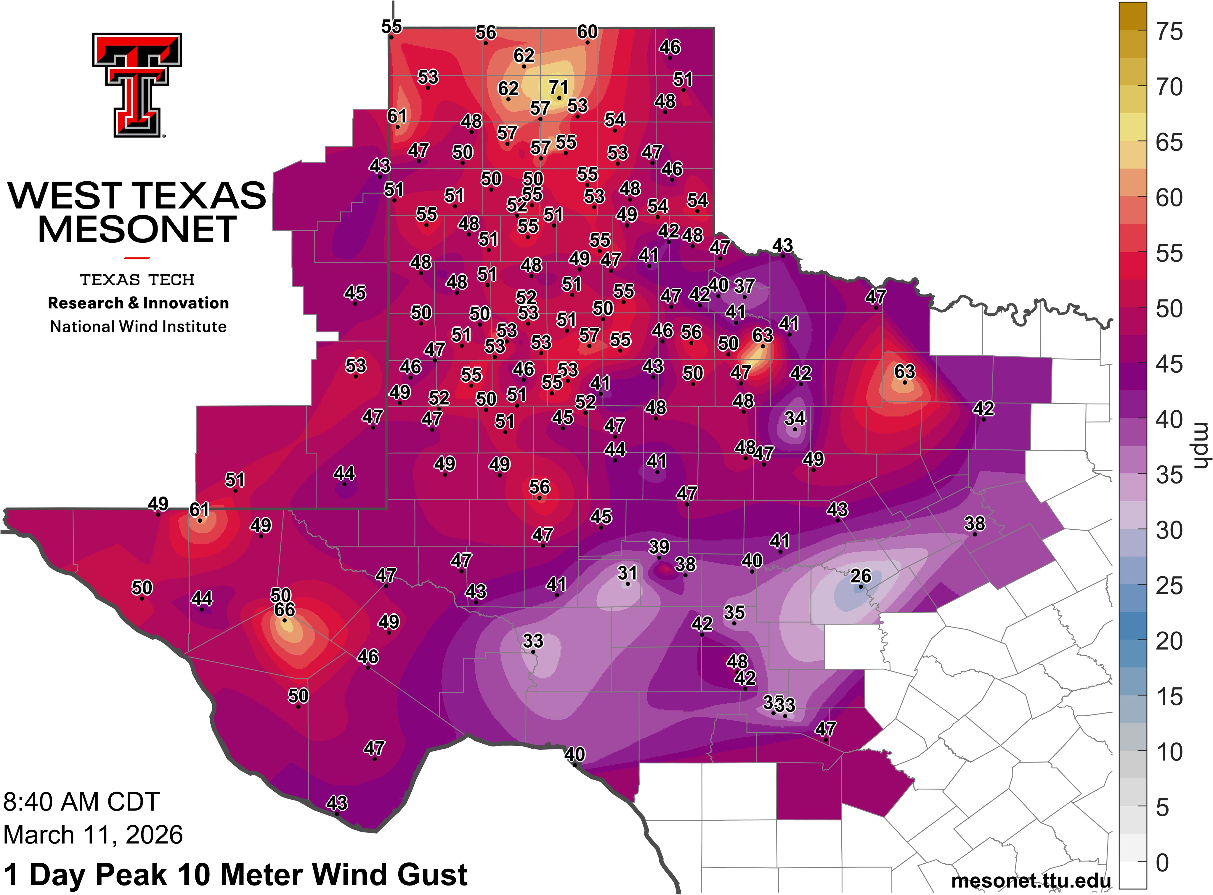
| Peak wind gusts through 8:40 am on Wednesday (11 March 2026). The graphic and data are courtesy of the West Texas Mesonet (WTM). Instantaneous peak wind gusts measured by the WTM at 9:45 am can be VIEWED HERE. | |
|
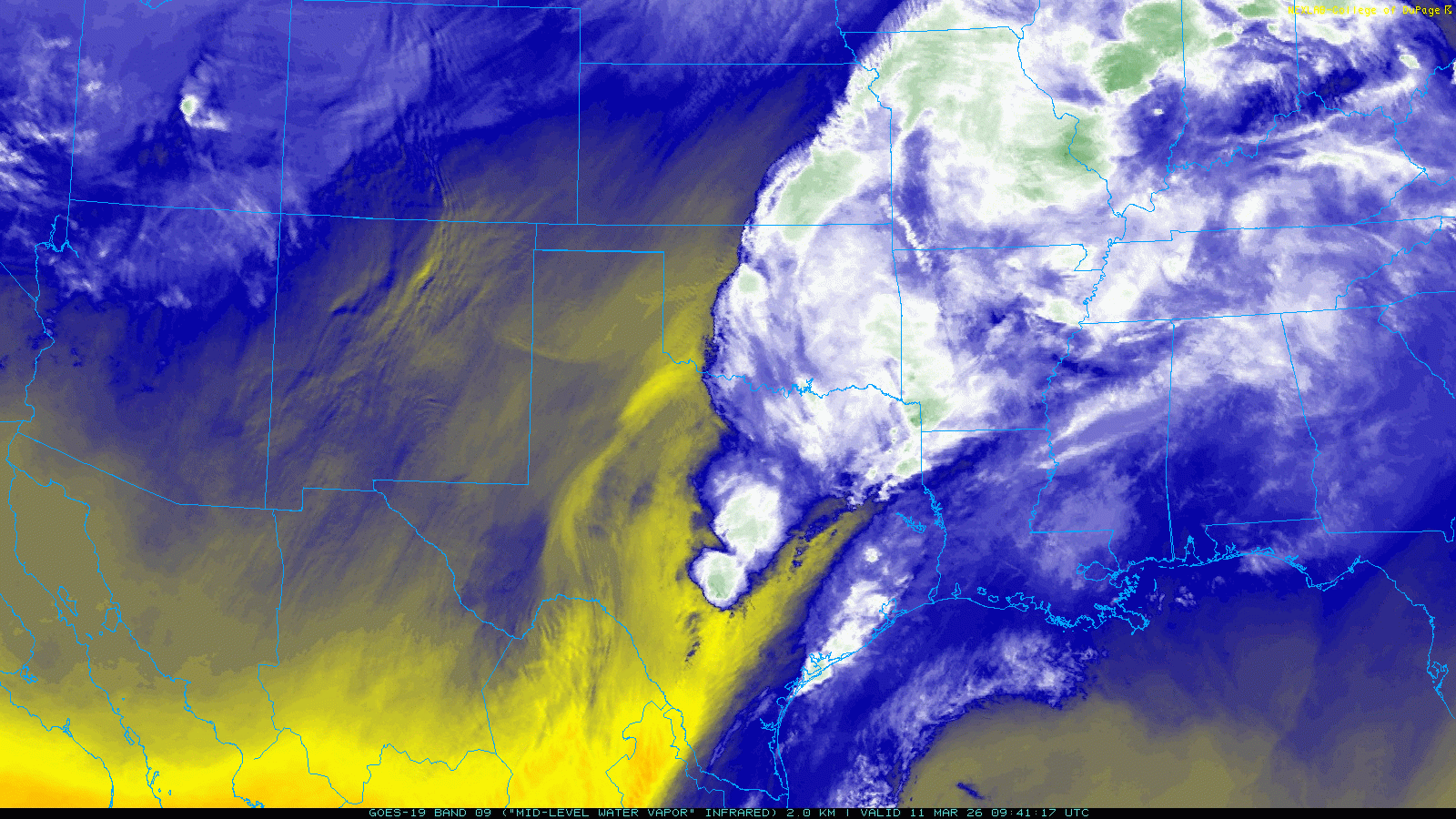
An early-day cold front swept through northwest Texas Wednesday morning (11 March). The front followed the passage of a mid-level disturbance that brought thunderstorms and severe weather to parts of Central and North Texas Tuesday afternoon and evening. A relative dearth of low-level moisture kept most of West Texas dry on Tuesday, as well as on Wednesday as the front moved through. |
|
 |
|
| Water vapor satellite animation valid from 4:01 am to 12:41 pm on Wednesday (11 March 2026). | |
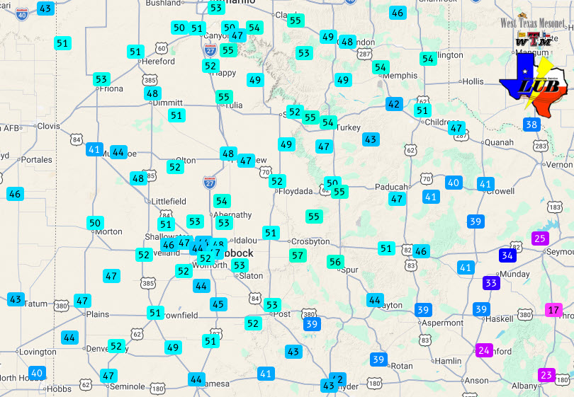
| What the front lacked in moisture, it more than made up for in wind. Northerly winds of 30 to 40 mph, with gusts in excess of 50 mph, were common behind the front. Spots in the north-central Texas Panhandle even experienced wind gusts in excess of 60 mph in the predawn hours, as high as 71 mph at the Stinnett West Texas Mesonet (WTM) at 3:53 am. The winds weren't quite as intense farther south, though several locations from Dimmitt to Lubbock, Ralls and Guthrie did measure gusts as high as 58 to 63 mph between late more and early afternoon. | |
 |
|
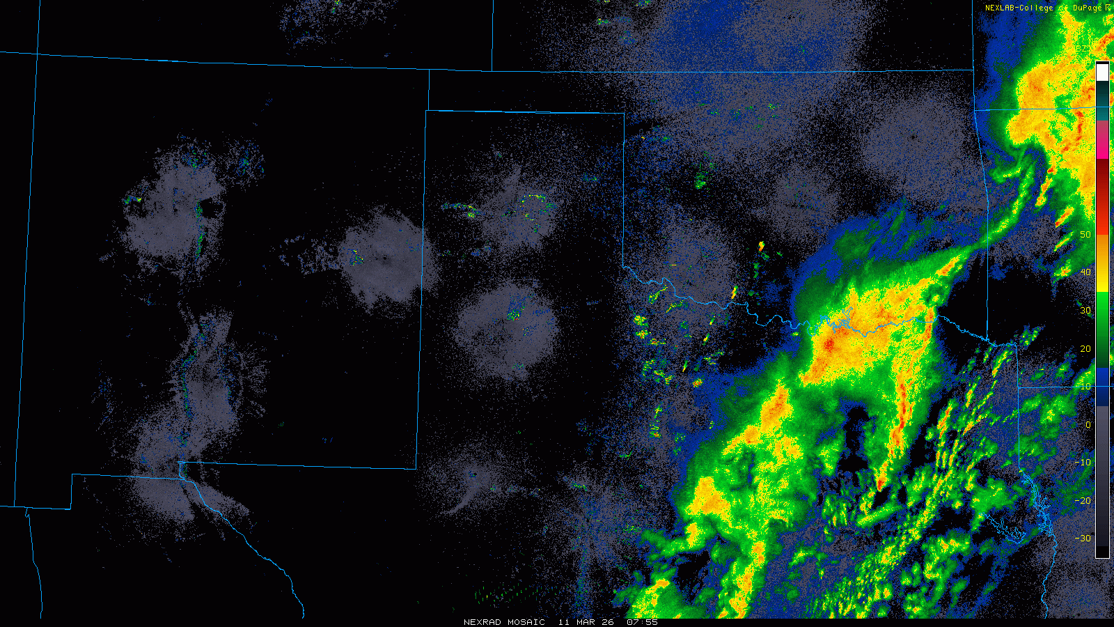
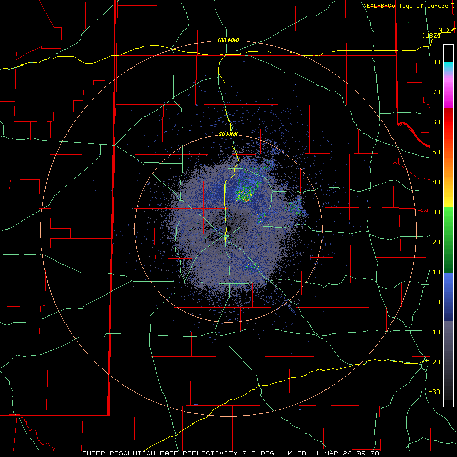
| Regional radar animation valid from 2:05 am to 9:05 am on Wednesday (11 March 2026). A Lubbock WSR-88D loop, valid from 4:20 am to 12:54 pm on Wednesday, can be FOUND HERE. | |
|
Officially, the Lubbock Airport recorded a peak wind gust of 60 mph, along with blowing dust that reduced the visibility as low as 1 to 2 miles at times. Thankfully, the winds quickly diminished late in the day, resulting in a pleasant evening despite highs only reaching the upper 50s to 60s during the day. Despite the dry and windy conditions, the cooler temperatures mitigated the overall fire danger, though the strong northerly winds did rekindle a wildfire that burned many acres near Boys Ranch, in the western Texas Panhandle. Preliminary wind reports collected by WFO Lubbock for this event can be found below. |
|
Preliminary Local Storm Report...Summary
National Weather Service Lubbock TX
429 PM CDT Wed Mar 11 2026

..TIME...   ...EVENT...      ...CITY LOCATION...     ...LAT.LON...
..DATE...   ....MAG....      ..COUNTY LOCATION..ST.. ...SOURCE....
            ..REMARKS..

1127 AM     Non-Tstm Wnd Gst 6 E New Deal            33.73N 101.74W
03/11/2026  M63 MPH          Lubbock            TX   Mesonet

            Peak gust as measured by the West Texas
            Mesonet.

1124 AM     Non-Tstm Wnd Gst 1 SE Ralls              33.67N 101.38W
03/11/2026  M62 MPH          Crosby             TX   Mesonet

            Peak gust as measured by the West Texas
            Mesont.

1027 AM     Non-Tstm Wnd Gst 3 N Hart                34.42N 102.11W
03/11/2026  M61 MPH          Castro             TX   Mesonet

            Measured by the West Texas Mesonet. The wind
            also gusted to 60 mph at 10:22 am and 10:30
            am.

1028 AM     Non-Tstm Wnd Gst 1 SE Ralls              33.67N 101.38W
03/11/2026  M60 MPH          Crosby             TX   Mesonet

            Measured by the West Texas Mesonet. The site
            also gusted to 58 mph at 10:25 am and 10:27
            am.

1045 AM     Non-Tstm Wnd Gst 2 NE Dimmitt            34.57N 102.29W
03/11/2026  M60 MPH          Castro             TX   Mesonet

            Measured by the West Texas Mesonet.

1031 AM     Non-Tstm Wnd Gst 6 E New Deal            33.73N 101.74W
03/11/2026  M59 MPH          Lubbock            TX   Mesonet

            Measured by the West Texas Mesonet.

1147 AM     Non-Tstm Wnd Gst 1 NNW Lubbock Int. Airp 33.67N 101.82W
03/11/2026  M59 MPH          Lubbock            TX   ASOS

            The strong winds also lofted thick blowing
            dust, reducing the visibility to 1 to 2 miles
            at times.

1236 PM     Non-Tstm Wnd Gst 8 SE Guthrie            33.55N 100.21W
03/11/2026  M59 MPH          King               TX   Mesonet

            Measured by the West Texas Mesonet.

1043 AM     Non-Tstm Wnd Gst 1 NNE Floydada          34.00N 101.33W
03/11/2026  M58 MPH          Floyd              TX   Mesonet

            Measured by the West Texas Mesonet.

