
Dangerous heat will expand from the Gulf Coast into the Southern Plains and Desert Southwest through week's end. Additional extreme heat impacting the Pacific Northwest will shift to the northern Plains by the weekend. Tropical Storm Bertha is expected to continue to impact portions of the northern Gulf Coast from the western Florida Panhandle to southeastern Louisiana through tonight. Read More >
|
Another cold front brings wind, dust and fire weather |
|
 |
|
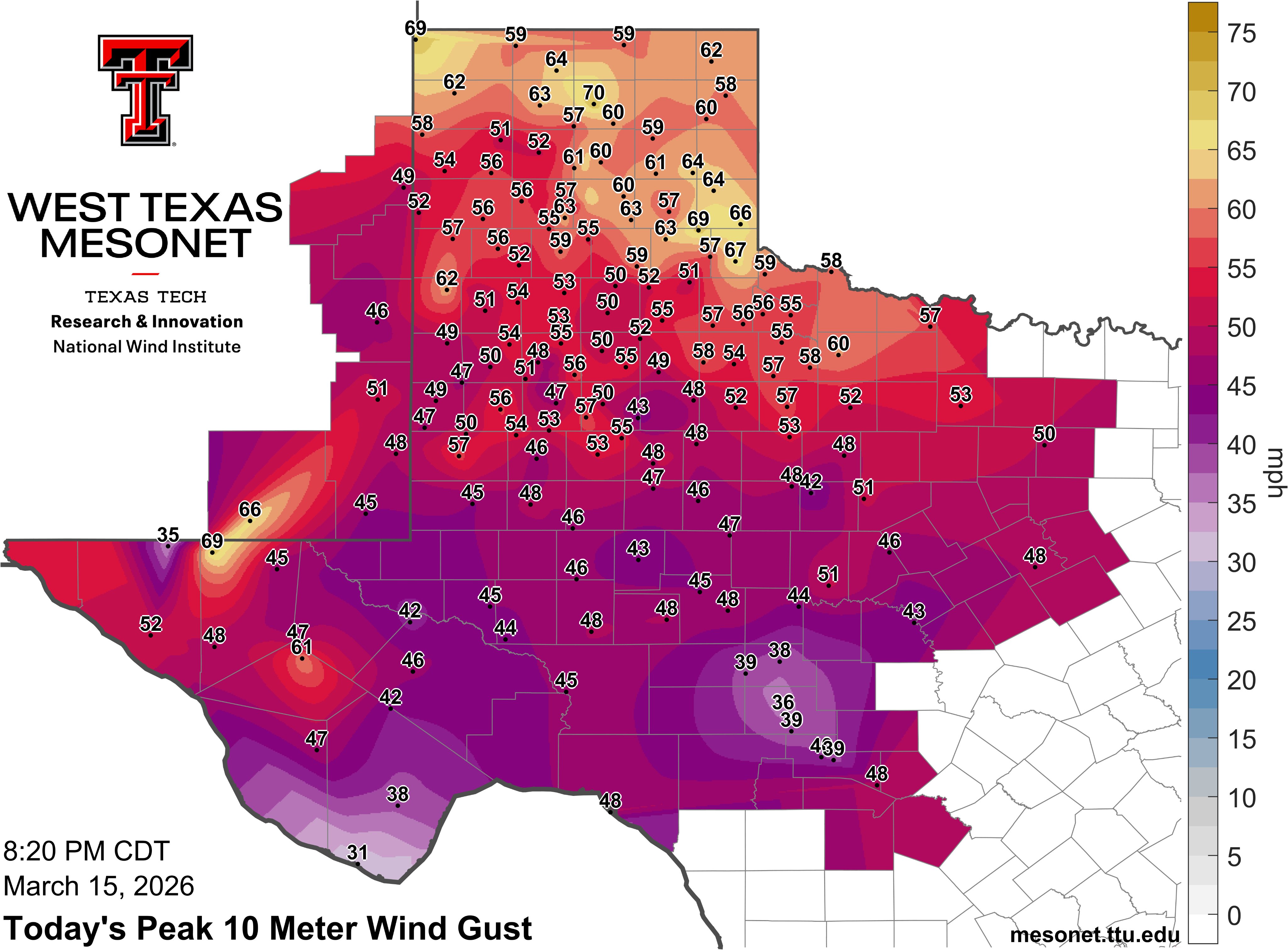
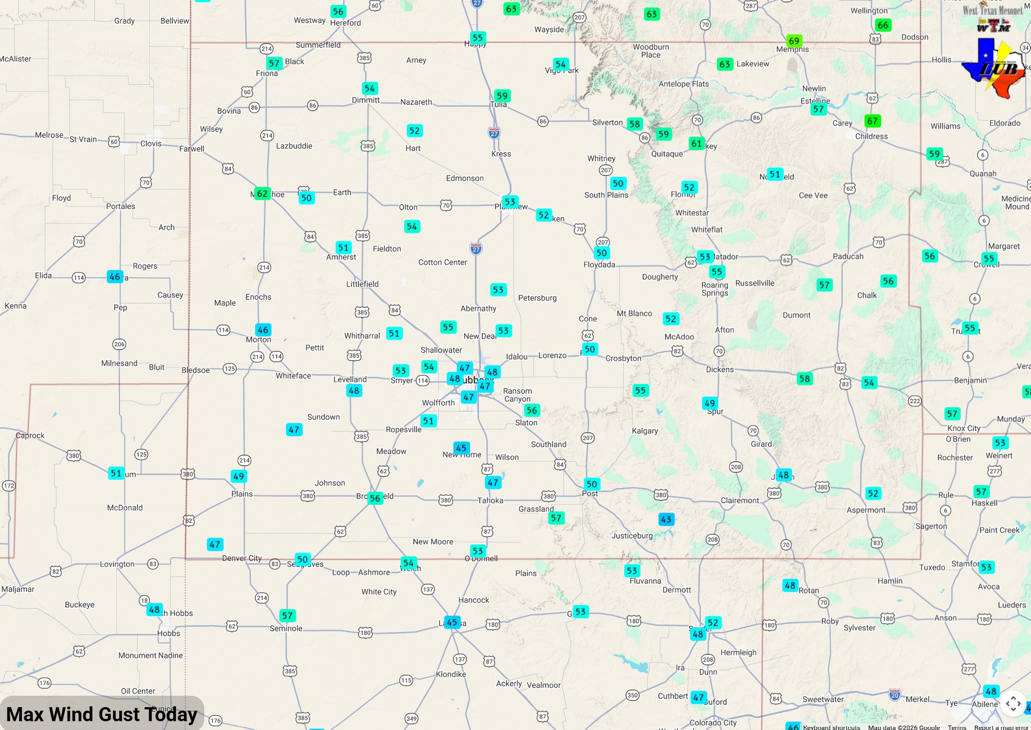
| Peak wind gusts through on Sunday (15 March 2026). The graphic and data are courtesy of the West Texas Mesonet (WTM). A closeup view of the South Plains region can be FOUND HERE. | |
|
A cold front plunged through the South Plains region Sunday morning (15 March), carrying in much colder air on gust north winds. The front moved through the southern Texas Panhandle near daybreak, and cleared the southern South and Rolling Plains by midday. The post-frontal northerly winds gusted from 45 to 55+ mph, with several gusts in excess of 60 mph measured, primarily over the northeast half or so of the Texas Panhandle. |
|
 |
|
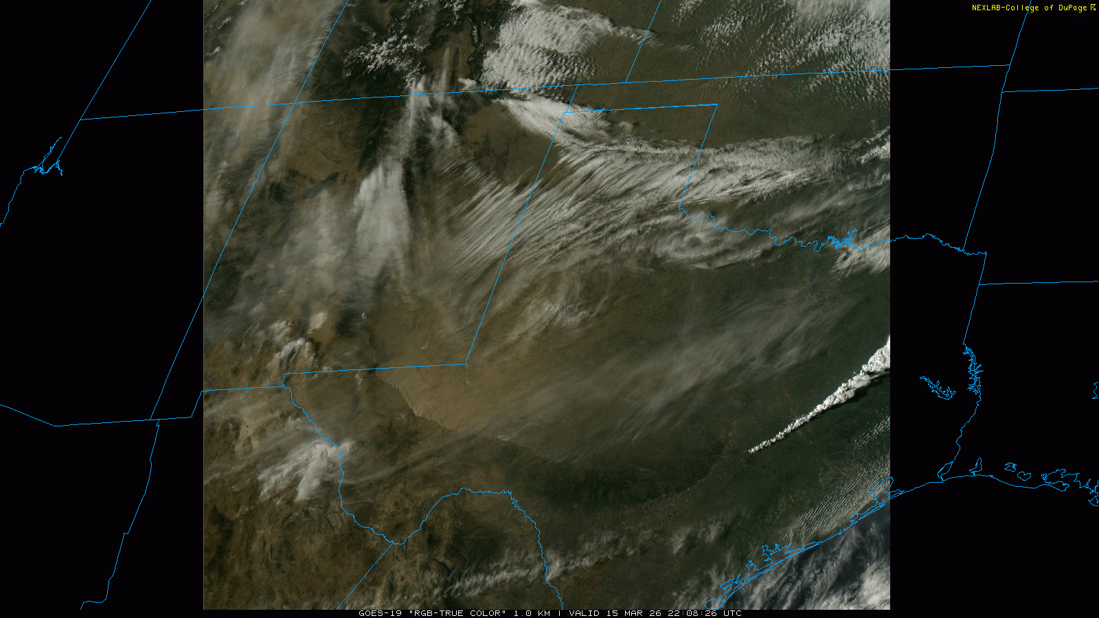
| "RGB-True Color" satellite animation valid from 5:09 pm to 5:32 pm on Sunday (15 March 2026). A zoomed in view of the Big Bend and Far West Texas, valid from 4:46 pm to 7:11 pm, can be VIEWED HERE. | |
| The intense winds lofted dust, which became widespread and thicker as the front plowed into the Permian Basin and Far West Texas through the afternoon hours. This led to the development of a haboob (wall of dust) that marched southwestward through Far West Texas and southeast New Mexico Sunday afternoon and evening. | |
 |
|
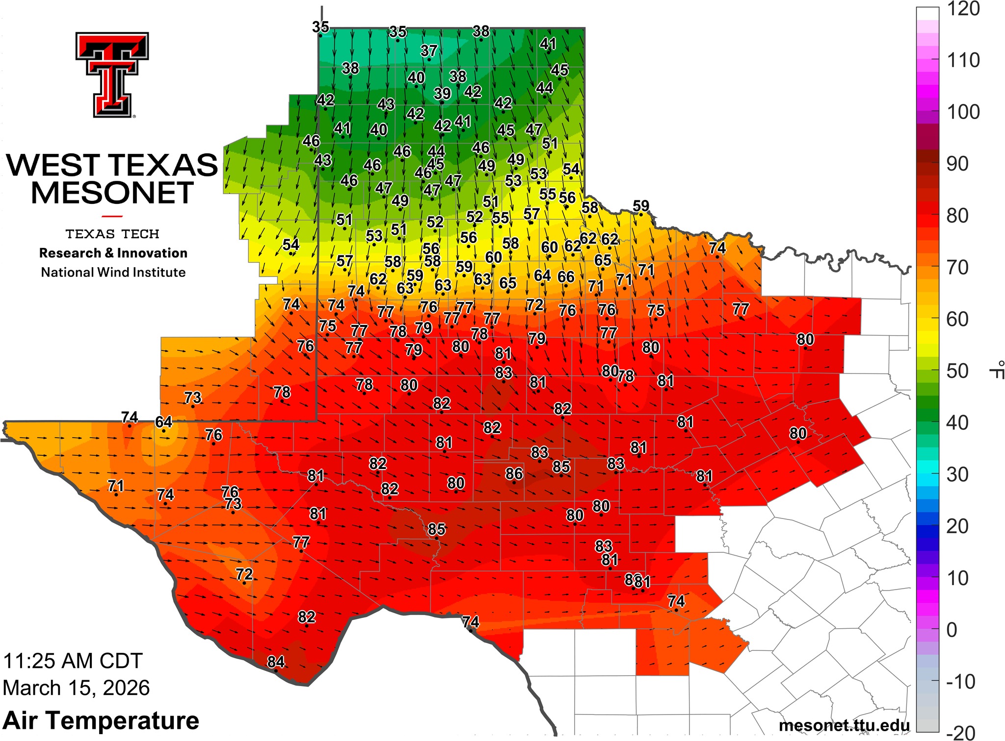
| Temperature at 11:25 am on Sunday (15 March 2026). The graphic and data are courtesy of the West Texas Mesonet (WTM). | |
|
Ahead of the cold front, temperatures soared into the 80s and lower 90s. This heat, in combination with dry and breezy westerly to northwesterly winds, created elevated to critical fire weather. The overall fire danger eased as the cooler and relatively moister air moved in behind the front, despite the stronger wind. |
|
 |
|
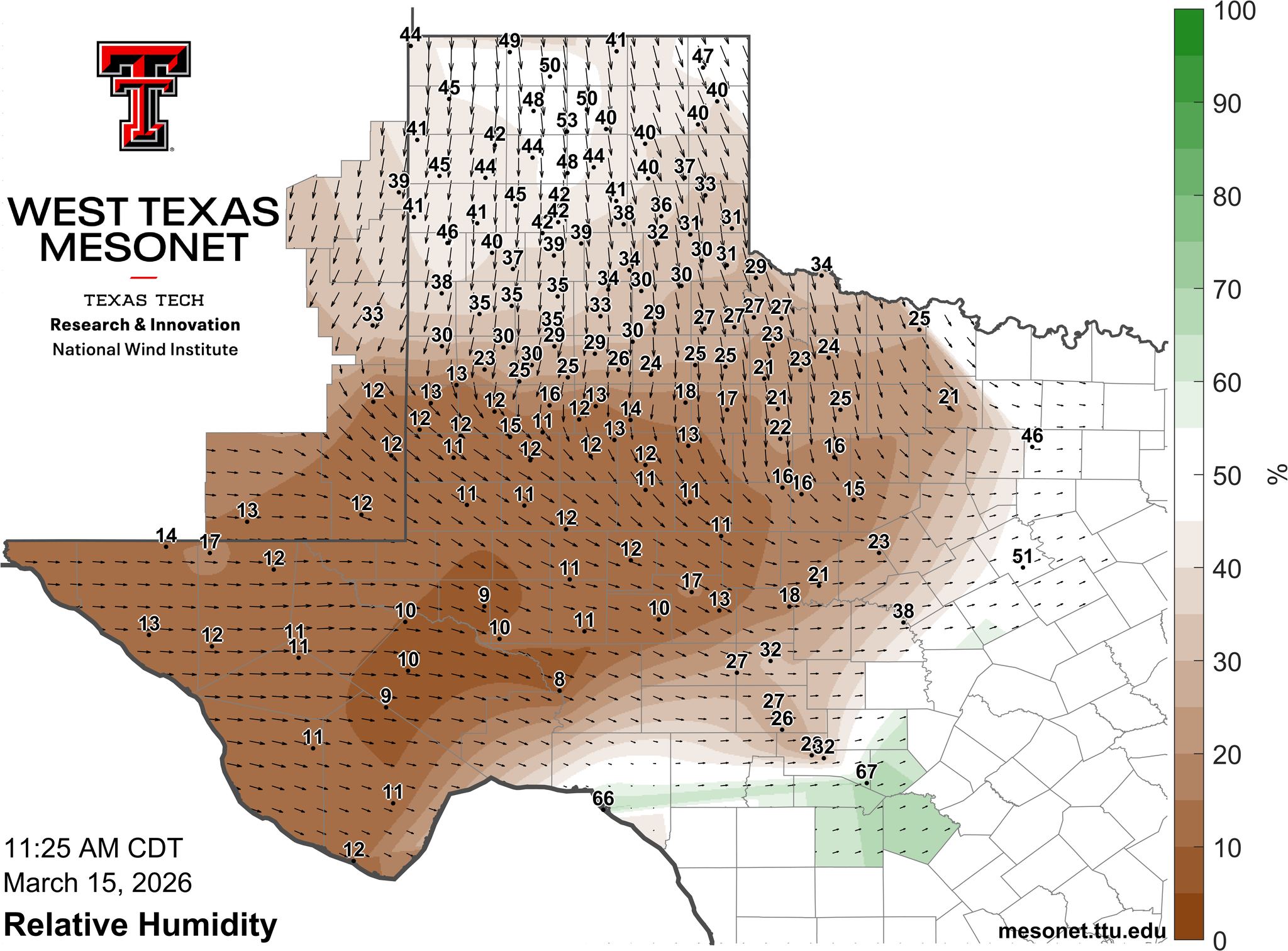
| Relative humidity (RH) at 11:25 am on Sunday (15 March 2026). The graphic and data are courtesy of the West Texas Mesonet (WTM). | |
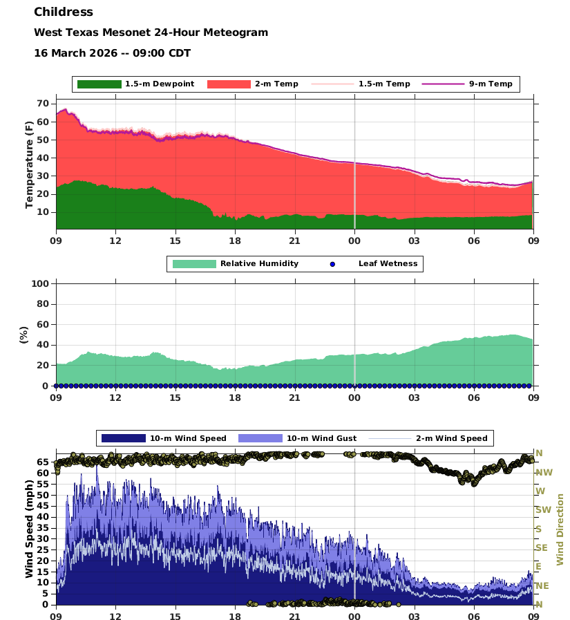
| The below graphs from Childress show the warmest temperatures, in the 60s, occurred ahead of the front before 10 am, then held relatively steady in the low to mid-50s through much of the afternoon, before plummeting in the evening and overnight. At the same time, winds peaked in the morning and early afternoon, but remained gusty through late afternoon and evening before finally diminishing after midnight. | |
 |
|
| Meteogram for the Childress WTM from Sunday into Monday (15-16 March 2026). The graphic and data are courtesy of the West Texas Mesonet (WTM). | |
| The impactful weather was not only confined to the region, but affected the entire center of the nation. Farther north, where colder air and moisture were in place, heavy snow and intense wind created a blizzard over the Upper Midwest into the western Great Lakes. Parts of Minnesota into Wisconsin received 1 to 2+ feet of snow to go along with winds gusting over 50 mph. | |
 |
|
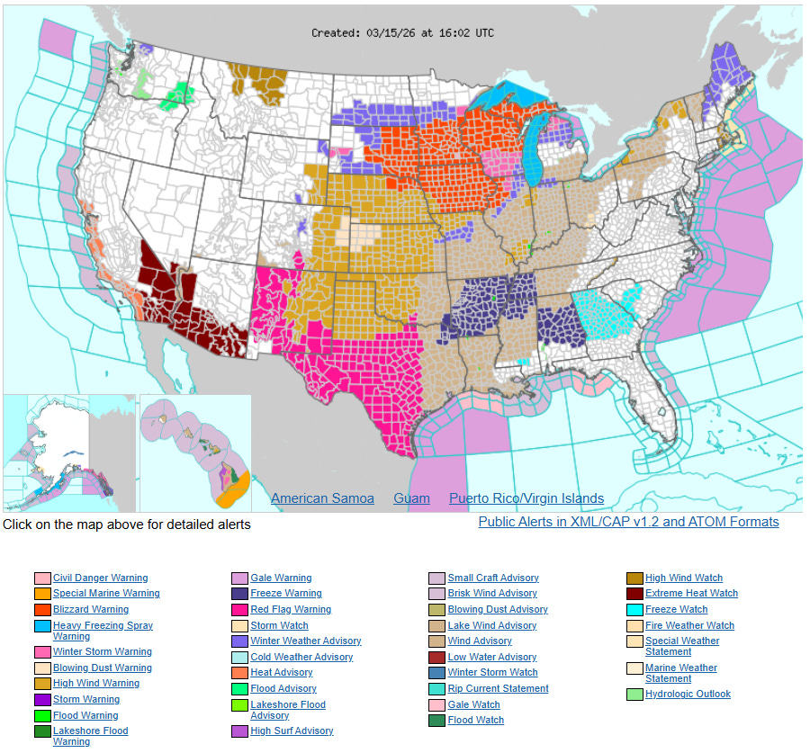
| Watch/Warning/Advisory display for the entire United States at 11 am on Sunday (15 March 2026). | |
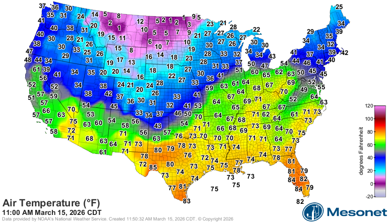
| The below map illustrates the tug of war between the building warmth across the southern United States and the advancing cold air across the north on this mid-March day. Temperatures ranged from the single digits in the northern High Plains to the 70s and 80s in Central and South Texas late Sunday morning. The impressive temperature differences provided the energy to fuel the widespread and impactful weather system. | |
 |
|
| Temperature observations across the entire United States at 11 am on Sunday (15 March 2026). | |
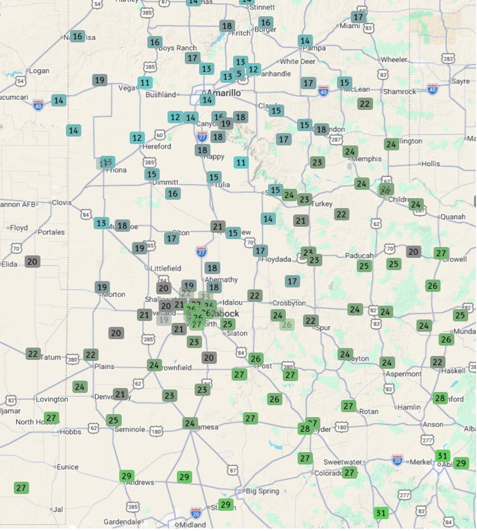
| After the winds subsided and the cold air settled into the region, temperatures bottomed out in the teens and lower to middle 20s Monday morning. Following the cold start, temperatures only rebounded into the 40s and lower 50s Monday afternoon. However, the chill didn't last very long, with highs jumping into the 70s on Tuesday, 80s on Wednesday and widespread 90s by Thursday. | |
 |
|
| Lows observed on Monday morning (16 March 2026). The data are courtesy of the West Texas Mesonet (WTM) and National Weather Service (NWS). | |
| Preliminary wind reports collected by WFO Lubbock for this event can be found below. |
Preliminary Local Storm Report...Summary
National Weather Service Lubbock TX
704 PM CDT Sun Mar 15 2026

..TIME...   ...EVENT...      ...CITY LOCATION...     ...LAT.LON...
..DATE...   ....MAG....      ..COUNTY LOCATION..ST.. ...SOURCE....
            ..REMARKS..

0919 AM     Non-Tstm Wnd Gst 1 NE Memphis            34.74N 100.53W
03/15/2026  M59 MPH          Hall               TX   Mesonet

            West Texas Mesonet.

1000 AM     Non-Tstm Wnd Gst 7 W Lakeview            34.68N 100.81W
03/15/2026  M59 MPH          Hall               TX   Mesonet

            West Texas Mesonet.

1003 AM     Non-Tstm Wnd Gst 1 SW Muleshoe           34.21N 102.74W
03/15/2026  M62 MPH          Bailey             TX   Mesonet

            Corrected source. West Texas Mesonet.

1007 AM     Non-Tstm Wnd Gst 4 W Childress           34.43N 100.28W
03/15/2026  M61 MPH          Childress          TX   ASOS


1031 AM     Non-Tstm Wnd Gst 2 ENE Tulia             34.55N 101.74W
03/15/2026  M59 MPH          Swisher            TX   Mesonet

            West Texas Mesonet.

1049 AM     Non-Tstm Wnd Gst 10 WSW Guthrie          33.57N 100.48W
03/15/2026  M58 MPH          King               TX   Mesonet

            West Texas Mesonet.

1053 AM     Non-Tstm Wnd Gst 1 NE Memphis            34.73N 100.53W
03/15/2026  M69 MPH          Hall               TX   Mesonet


1055 AM     Non-Tstm Wnd Gst 1 NNW Lubbock Int. Airp 33.67N 101.82W
03/15/2026  M60 MPH          Lubbock            TX   ASOS


1102 AM     Non-Tstm Wnd Gst 2 NNE Childress         34.46N 100.20W
03/15/2026  M67 MPH          Childress          TX   Mesonet


1108 AM     Non-Tstm Wnd Gst 2 S Lesley              34.65N 100.81W
03/15/2026  M63 MPH          Hall               TX   Mesonet


1119 AM     Non-Tstm Wnd Gst 7 ESE Silverton         34.45N 101.19W
03/15/2026  M58 MPH          Briscoe            TX   Mesonet

            West Texas Mesonet.

1129 AM     Non-Tstm Wnd Gst 2 S Caprock Canyons Sta 34.42N 101.07W
03/15/2026  M59 MPH          Briscoe            TX   Mesonet

            West Texas Mesonet.

1225 PM     Non-Tstm Wnd Gst 2 WSW Turkey            34.39N 100.93W
03/15/2026  M59 MPH          Hall               TX   Mesonet

            West Texas Mesonet.

1228 PM     Non-Tstm Wnd Gst 2 WSW Turkey            34.38N 100.93W
03/15/2026  M61 MPH          Hall               TX   Mesonet


1253 PM     Non-Tstm Wnd Gst 4 W Childress           34.43N 100.28W
03/15/2026  M58 MPH          Childress          TX   ASOS

