
Numerous severe thunderstorms are expected across a broad region from the Ohio Valley to the Mid-Atlantic and Northeast States today into tonight. Swaths of damaging wind gusts are expected and some tornadoes are possible. Bertha is expected to bring tropical storm conditions to portions of the Gulf Coast from the Florida Panhandle westward to southeastern Louisiana later today and Wednesday. Read More >
|
More wind behind a cold front |
|
 |
|
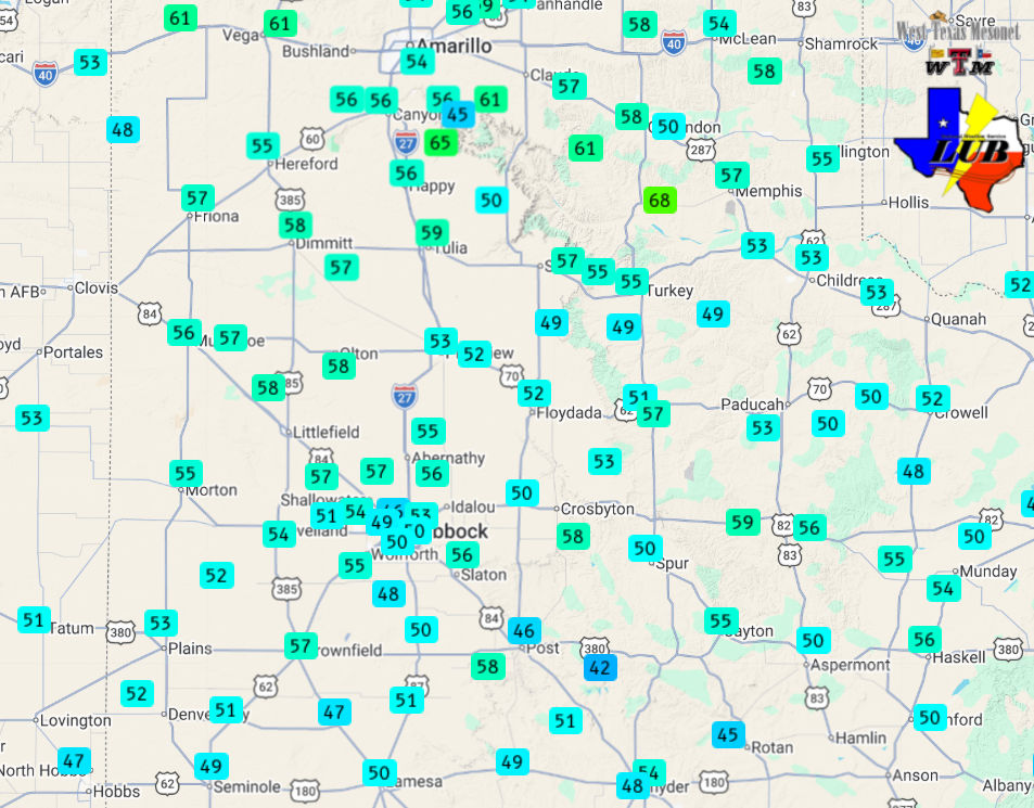
| Peak wind gusts measured on Friday (27 March 2026). The graphic and data are courtesy of the West Texas Mesonet (WTM). | |
|
Can you say Deja vu? For the third time in March, an early-day cold front blasted through the South Plains. Similar to the previous fronts, it brought no precipitation, but it did supply plenty of wind and colder air. This front moved out of the Texas Panhandle after 2 am on Friday (27 March) and swept through the South Plains and Rolling Plains over the next several hours, exiting the southern Rolling Plains before daybreak. |
|
 |
|
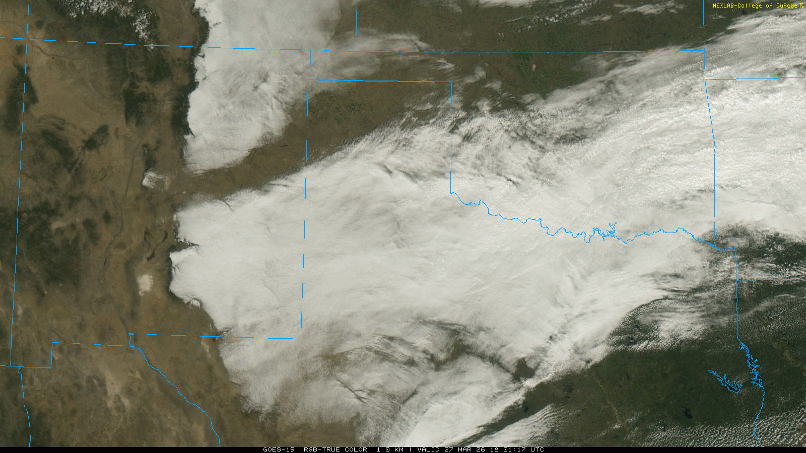
| "RGB-True Color" satellite animation valid from 1:01 pm to 2:56 pm on Friday (27 March 2026). | |
| The initial frontal passage brought modest amounts of dust to many locations, with the visibility briefly dropping down from 3 to 5 miles. Additionally, northerly winds rapidly ramped up, with gusts of 45 to 55 mph being common. Several sites experienced wind gusts near or above 60 mph in the predawn hours, including 60 mph at the Lubbock Airport and 68 mph at the West Texas Mesonet (WTM) site near Lesley. The severe-caliber gusts ceased after sunrise, but northerly to northeasterly winds of 25 to 35 mph, with gusts to 50 mph, persisted through much of the day before finally diminishing Friday evening. | |
 |
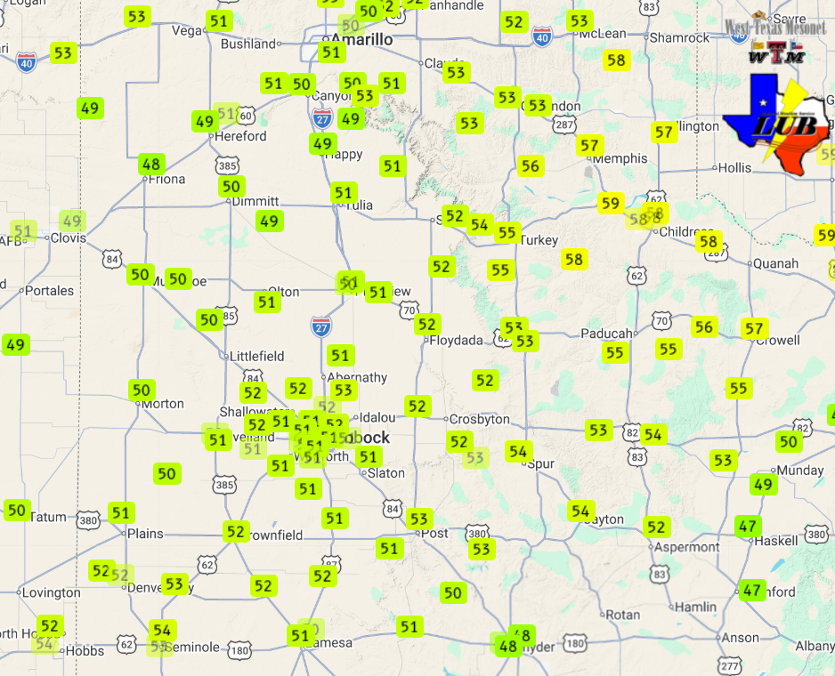 |
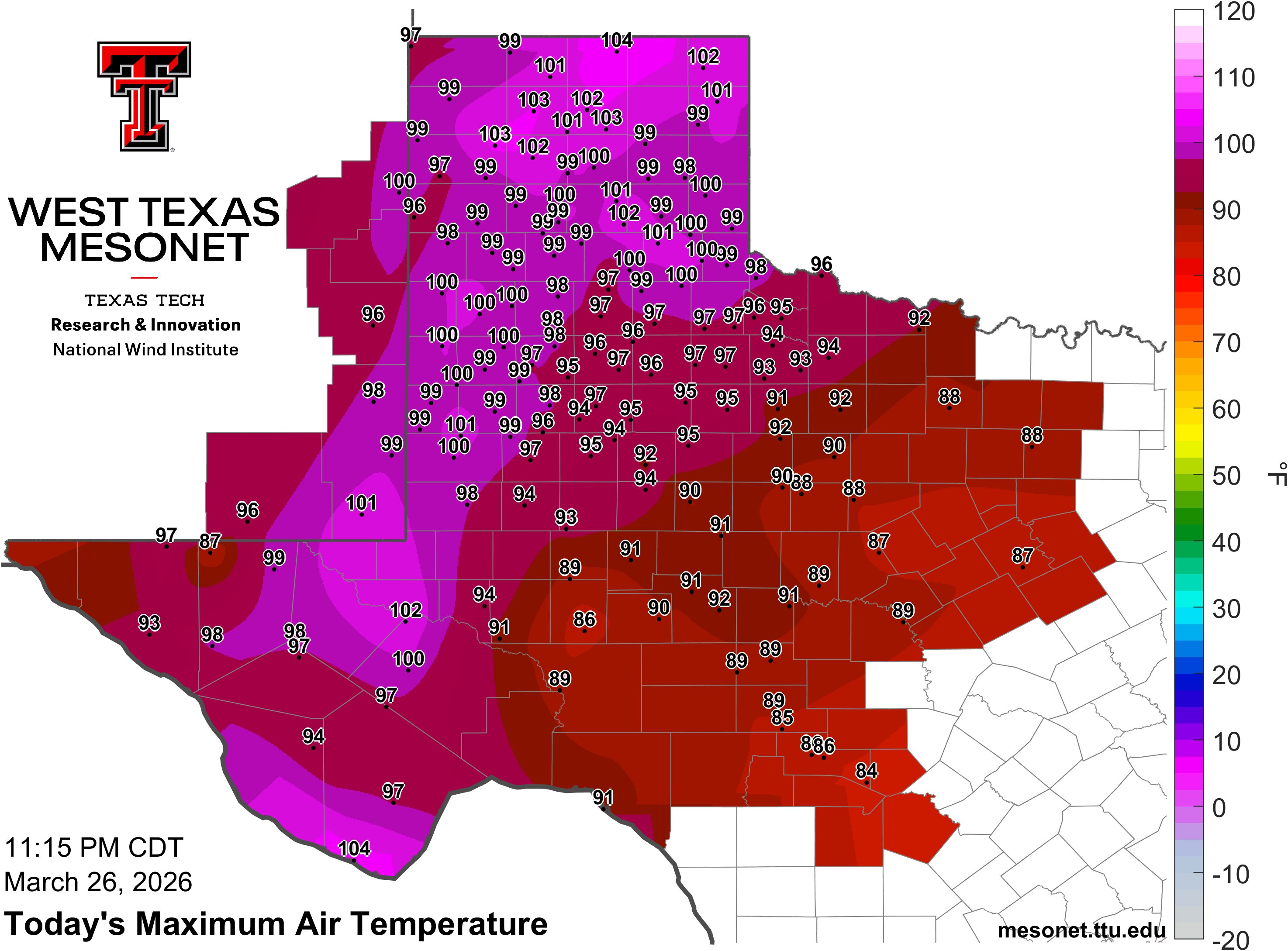
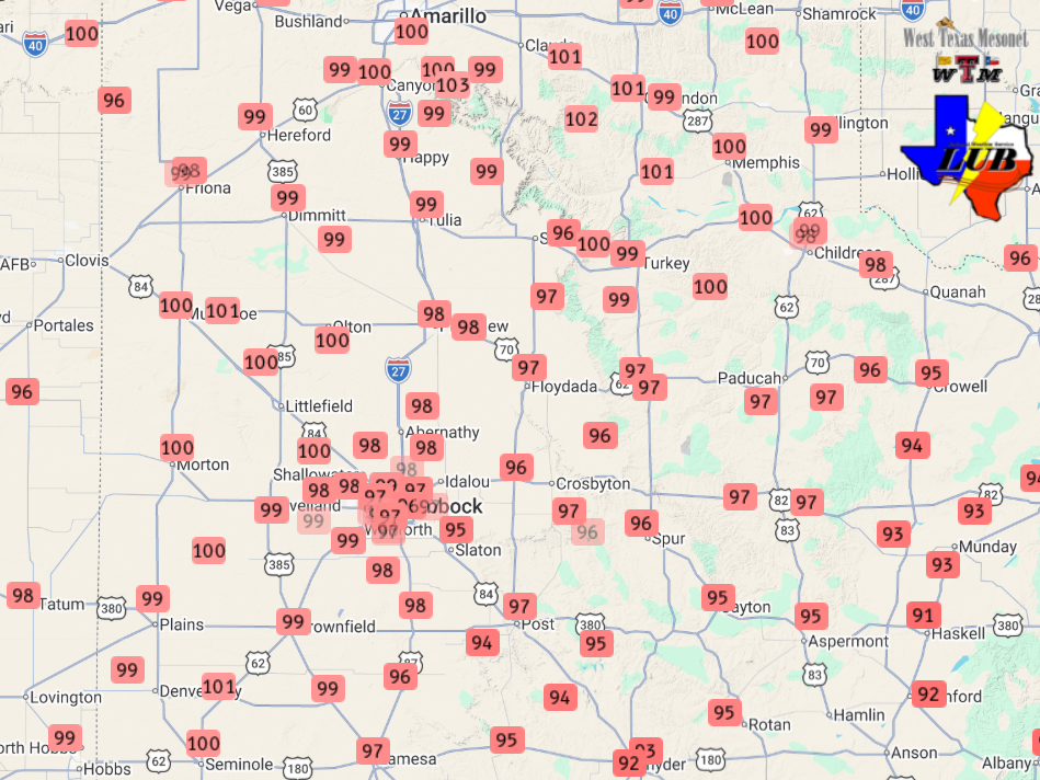
| (Left) High temperatures observed on Thursday (26 March 2026). The graphic and data are courtesy of the West Texas Mesonet (WTM). A close up view of the South Plains region can be FOUND HERE. (Right) Temperatures measured by the WTM at 3 pm on Friday (27 March 2026). | |
|
The northerly winds carried in much colder air, which was enhanced by thick and persistent cloud cover that filled in behind the front and lasted all afternoon and evening. The cool down felt even more dramatic coming on the heels of record heat the previous day when temperatures soared well into the 90s. Many locations across the western South Plains into the southern Texas Panhandle even briefly breached the triple digits! Behind the front, temperatures were stuck in the 40s much of the day Friday, though did edge into the lower and middle 50s late in the day. |
|
 |
|
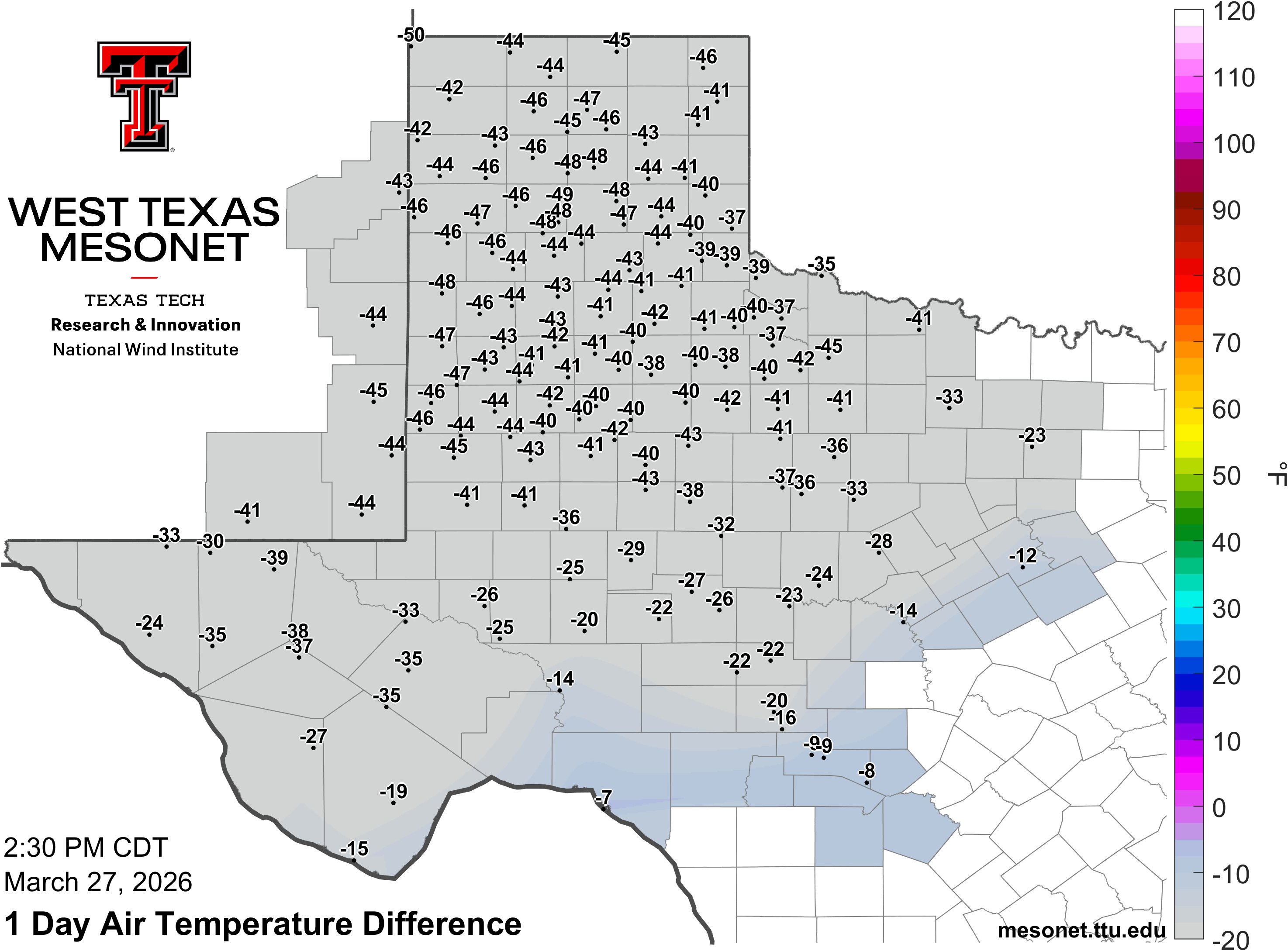
| 24-hour temperature difference valid at 2:30 pm on Friday (27 March 2026). The graphic and data are courtesy of the West Texas Mesonet (WTM). | |
|
Altogether, the record hot Thursday, followed by the chilly Friday, saw much of the region experiencing a 40 to 50 degree temperature drop from Thursday afternoon to Friday afternoon! Plus, the lack of sunshine and stout winds made it feel even colder through the day on Friday. Preliminary wind reports collected by WFO Lubbock for this event can be found below. |
|
Preliminary Local Storm Report...Summary
National Weather Service Lubbock TX
230 PM CDT Fri Mar 27 2026

..TIME...   ...EVENT...      ...CITY LOCATION...     ...LAT.LON...
..DATE...   ....MAG....      ..COUNTY LOCATION..ST.. ...SOURCE....
            ..REMARKS..

0253 AM     Non-Tstm Wnd Gst 2 NE Dimmitt            34.57N 102.29W
03/27/2026  M58 MPH          Castro             TX   Mesonet


0254 AM     Non-Tstm Wnd Gst 2 S Lesley              34.65N 100.81W
03/27/2026  M68 MPH          Hall               TX   Mesonet


0331 AM     Non-Tstm Wnd Gst 2 ENE Tulia             34.54N 101.74W
03/27/2026  M59 MPH          Swisher            TX   Mesonet


0342 AM     Non-Tstm Wnd Gst 6 S Olton               34.09N 102.12W
03/27/2026  M58 MPH          Lamb               TX   Mesonet


0356 AM     Non-Tstm Wnd Gst 1 NE Amherst            34.02N 102.40W
03/27/2026  M58 MPH          Lamb               TX   Mesonet


0400 AM     Non-Tstm Wnd Gst 1 NNW Lubbock Int. Airp 33.67N 101.82W
03/27/2026  M58 MPH          Lubbock            TX   ASOS


0503 AM     Non-Tstm Wnd Gst 10 WSW Guthrie          33.57N 100.48W
03/27/2026  M59 MPH          King               TX   Mesonet


0525 AM     Non-Tstm Wnd Gst 5 SSW Graham            33.08N 101.52W
03/27/2026  M58 MPH          Garza              TX   Mesonet


0548 AM     Non-Tstm Wnd Gst 6 NW White River Lake   33.53N 101.17W
03/27/2026  M58 MPH          Crosby             TX   Mesonet

