|
| Yearly Reports |
| Interested in what kind of weather occurred in a recent year? Check out the most memorable events below. |
|
|
 |
Arkansas Yearly Climate Summary (2015)/Pg2 |
 |
| |
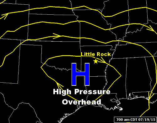 |
| In the picture: A large ridge of high pressure ("H") was over Arkansas at 700 am CDT on 07/19/2015. |
|
| |
|
The dryness over the southeast United States became the theme in southern Arkansas during the summer (June through August). A large ridge of high pressure shut off the rain, and triple digit heat was felt in late July and early August. The hottest day was August 10th. The mercury reached 107 degrees at De Queen (Sevier County), 106 degrees at Texarkana (Miller County), and 105 degrees at El Dorado (Union County).
|
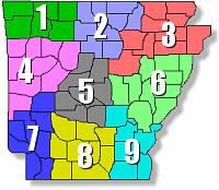 |
Drought conditions developed and worsened heading into the fall. From July 20th through October 17th (90 days), climate districts 7, 8, and 9 (in the south) only got 2.75 to 3.75 inches of rain (normal is 9.50 to 11.00 inches). It was the driest for this time frame in roughly 130 years of records. |
| In the picture: There are nine climate districts in Arkansas. |
|
It was the driest September on record at Little Rock (Pulaski County) and Pine Bluff (Jefferson County) dating back to 1874 and 1883 respectively. At the former location, it was the 7th driest month overall (tied with June, 1953 and June, 1930). At the latter location, it was the 5th driest month ever (tied with July, 1893).
|
|
To add to the misery, it got hot in October. The 15th was the hottest October day in recorded history at Little Rock (Pulaski County). The thermometer showed 98 degrees, which eclipsed the previous monthly record of 97 degrees on the 10th and 11th of 1963.
|
|
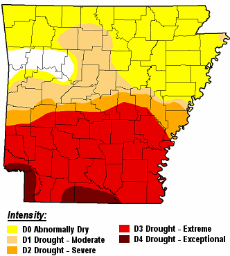
By October 20th, a moderate to extreme drought (D2 to D4) existed across much of central and southern Arkansas. Burn bans were posted in 61 of 75 counties.
|
| |
| Drought Conditions (Percent Area) |
| Category |
Coverage |
| None |
4.30% |
| D0-D4 |
95.70% |
| D1-D4 |
60.38% |
| D2-D4 |
45.60% |
| D3-D4 |
38.22% |
| D4 |
3.59% |
|
|
| In the picture: Severe to exceptional drought (D2 to D4) conditions existed across the southern half of Arkansas on 10/20/2015. |
|
While it was like a tinderbox around here, the drought in South Carolina became a distant memory. A 1-in-1,000-year rain event unfolded during the first week of October. The 3rd was the rainiest day in recorded history at Charleston, SC (11.50 inches), and the same happened on the 4th at Columbia, SC (6.87 inches). Flooding was catastrophic, and evacuations were ordered as dams/levees failed.
|
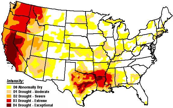 |
| In the picture: Drought conditions as of 10/20/2015. |
|
| |
|
There was no such deluge in California, which was bracing for a fifth year of drought. A state of emergency was issued in January, 2014, and that was followed by a first-ever 25 percent statewide mandatory water reduction in April (and a list of actions to save water). In late October, 2015, the state asked for federal assistance to remove an estimated 22 million dead and dying trees. The tree mortality was so high that it significantly worsened the wildfire risk.
|
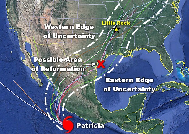 |
| In the picture: Major Hurricane (Category 4) Patricia was 275 miles south of Manzanillo, Mexico during the afternoon of 10/22/2015. Maximum sustained winds were around 130 mph. Patricia became the strongest hurricane on record in the western hemisphere the next day (a central pressure of 879 millibars/25.96 inches), with winds reaching 200 mph (Category 5). Most models (colored lines) showed the remnants of Patricia tracking toward south Texas, with a new system forming close to the coast by 10/25/2015 and exiting slowly to the northeast. |
|
| |
|
An emerging El Niño promised that appreciable rain would eventually build over the southern United States (and California) as fall/winter progressed. It started happening from October 23rd through the 27th. An incoming storm system from the Plains combined with the remnants of Hurricane Patricia from the Pacific Ocean yielded two to more than five inches of liquid where it was needed the most (southern Arkansas).
There was more life threatening flooding in Texas. Near Corsicana, TX, at least 20 inches of rain was reported, and this was responsible for derailing a train. Sections of Interstate 45 were shut down between Dallas, TX and Houston, TX. More than a foot of liquid fell between Austin, TX and San Antonio, TX. The Austin-Bergstrom International Airport was closed temporarily due to water in air traffic control. Dozens of high water rescues were performed (people pulled from stranded vehicles). Roads were also washed away. The deluge in Texas was responsible for at least six fatalities.
A wet pattern continued in November, and this almost completely wiped out the drought locally. By the time the month ended, it was the wettest November on record in Arkansas (a statewide average of 10.65 inches topped the previous record of 9.37 inches in 1988).
|
| Wettest Novembers on Record in Arkansas |
| Year |
Rain (Inches) |
| 2015 |
10.65 |
| 1988 |
9.37 |
| 1957 |
9.17 |
| 2004 |
8.99 |
| 2000 |
8.97 |
| Note: The statewide average precipitation in November is 4.29 inches. |
|
|
| In the video: Strong to damaging winds were captured along Lake Hamilton (Garland County) on 11/17/2015. The video is courtesy of Gina Martin. |
|
| |
|
Along with the rain came some severe weather. On the 17th, there was a lot of wind aloft, and this gave storms a fast forward movement. This usually makes wind damage more likely. To give an idea of just how strong the winds were overhead, the National Weather Service in Little Rock (Pulaski County) launched a balloon between 500 pm and 600 pm CST. In just 77 minutes, the balloon was 115 miles away, or 9 miles east of Hardy (Sharp County).
The most extensive damage happened on the south side of Hot Springs (Garland County). Most of the damage was near Lake Hamilton (Garland County) along Highway 7, with 60 to 80 mph winds moving across the water and then inland. Trees fell into homes, roofs were partially removed from buildings, and windows were blown out. Much of the city lost power, including schools. Classes ended early and students were sent home.
|
|
|
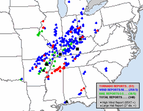
| In the picture: Reports of severe weather on 12/23/2015. The graphic is courtesy of the Storm Prediction Center. |
|
| |
|
If you are looking for a month of extremes, that was saved for last. December had everything. Severe storms cranked up early on the 23rd. At 740 am CST, trees were downed near Atkins (Pope County), and one tree fell through a house. An 18-year-old female was killed. As storms pushed toward the Mississippi River, hail cores became more prevalent in developing storms. Just south of Jonesboro (Craighead County), up to baseball size hail killed numerous geese. There were two tornadoes (rated EF1/EF2) counted across the state.
The biggest storm of the day was in Mississippi and southwest Tennessee. The storm generated two powerful long-track tornadoes (63 miles and 75 miles), and Holly Springs, MS was one of the hardest hit communities. The latter tornado (rated EF4) was responsible for 9 fatalities, making this the deadliest tornado in 2015.
|
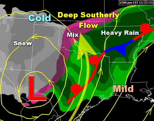 |
| In the picture: A powerful storm system ("L") interacted with a stalled front to bring flooding rain to Arkansas and heavy snow to parts of the southern Rockies and southern Plains on 12/27/2015. |
|
| |
|
As the holiday season approached, a very complex weather pattern evolved. Heavy rain/extensive flooding was expected here at home, with severe weather just to the southwest, and blizzard conditions toward the Texas panhandle and in New Mexico.
It felt like spring on the 26th. Temperatures in much of Arkansas climbed into the 70s to lower 80s. At Little Rock (Pulaski County), the mercury made it to 81 degrees, which set an all-time December high temperature record at the site.
During the evening of the 26th, one of the bigger headlines was a tornado (rated EF4) hitting the east side of Dallas, TX (the suburbs of Garland and Rowlett). Eight people lost their lives.
On the 27th, 12.4 inches of snow piled up in Roswell, NM. It was the snowiest day ever recorded in town. Winds gusted to 60 mph, and this created snow drifts up to 10 feet.
|
|
|
| |
|
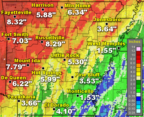
After it got warm locally, the clouds unleashed a torrent of water in the Ozark and Ouachita Mountains (the northern and western counties). Seventy two hour rainfall through 600 pm CST on the 28th included 8.32 inches at Fayetteville (Washington County), 8.29 inches at Russellville (Pope County), 7.79 inches at Mount Ida (Montgomery County), 7.03 inches at Fort Smith (Sebastian County), 6.34 inches at Mountain Home (Baxter County), 6.22 inches at DeQueen (Sevier County), 5.99 inches at Hot Springs, and 5.88 inches at Harrison (Boone County). To put this into perspective, two months of rain fell in just a few days in some cases.
Tragically, there was at least one flash flood fatality. A man tried to drive through a low water crossing near Dover (Pope County) and was swept downstream.
The yearly total at Big Fork (Polk County) eclipsed 100 inches (101.05 inches), which had only been done once before (100.05 inches) at Leola (Grant County) in 2009.
|
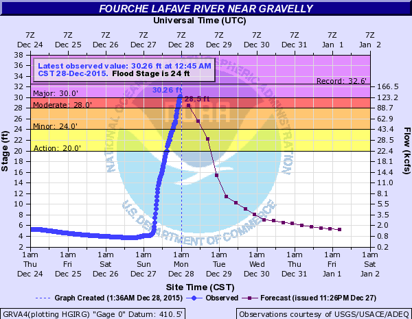 |
| In the picture: The Fourche LaFave River at Gravelly (Yell County) was within two feet of a record crest at 1245 am CST on 12/28/2015. Less than four hours later, the river topped out less than a foot away from the record (a Top 3 crest). |
|
| |
|
Much of the liquid from this event made it into area tributaries, with moderate to major flooding along the Arkansas, Black, Buffalo, Cache, Eleven Point, Fourche LaFave, Petit Jean, Spring, and White Rivers. Crests were within a foot or two of all-time records on portions of the Arkansas River west of Little Rock (Pulaski County), and on the Fourche LaFave and Petit Jean Rivers. Several of these crests were higher than those established in May.
On the 27th/early on the 28th, seven more tornadoes (rated EF1/EF2) touched down, mainly across southern sections of the state. This brought the yearly total to 20, which was below the normal of 33.
|
| An Unprecedented Event? |
|
Some may wonder if there was ever an event like this in December. After all, it is supposed to be cold with maybe a chance of snow or ice. An episode with a ton of rain, flooding, and tornadoes is very rare for this time of year, right?
While something of this magnitude so late in the year is a little out of the ordinary, it is not unprecedented. The year 1982 comes to mind. On the 2nd and 3rd, Mother Nature dumped more than ten inches of rain in parts of the Ozark and Ouachita Mountains. Mountain View (Stone County) got a staggering 15.56 inches in the two days, with 15.37 inches at Clinton (Van Buren County), 14.00 inches at Melbourne (Izard County), 12.55 inches at Washita (Montgomery County), 12.53 inches at Mammoth Spring (Fulton County), and 10.18 inches at Deer (Newton County). Six deaths resulted, mostly from automobiles driving into high water.
This is an entry in Storm Data about the flooding in Clinton (Van Buren County):
"Devastation in Clinton, Van Buren County, began about 9 pm, December 2, when waters from the south fork of the Little Red River, Archey Fork of the Little Red, and Town Branch began backing up into the business district. By midnight, merchants were fighting a losing battle to save their businesses from the rising water. By morning, the Clinton business district resembled a lake, dotted with the rooftops of submerged buildings."
The Buffalo River at St. Joe (Searcy County) rocketed to 53.75 feet on the 3rd. This is a record crest that still stands today. Top 3 crests were reached on the Fourche LaFave River at Gravelly (Yell County) and Houston (Perry County), and on the Petit Jean River at Danville (Yell County). There was also a Top 5 crest on the White River at Batesville (White County).
Sixteen tornadoes were documented, and seven of them were rated F3. Most of these were in northern and central sections of the state. The tornadoes were responsible for two fatalities and 75 injuries.
|
|
Water was at record high levels south of St. Louis, MO after the rain in late December. The Maramec River flooded hundreds of homes and businesses, and closed Interstate 44 for several days near Arnold, MO. Interstate 55 was also closed due to a rising Mississippi River. Farther downstream, at least 125 homes just east of Cape Girardeau, MO (on the Illinois side of the river) were surrounded by water. Evacuations were ordered in Branson, MO as Lake Taneycomo filled beyond capacity.
|
|
|