|
| Yearly Reports |
| Interested in what kind of weather occurred in a recent year? Check out the most memorable events below. |
|
|
 |
Arkansas Yearly Climate Summary (2015)/Pg1 |
 |
| |
|
| 2015 Statistics |
| Month |
Tornadoes |
Tornado Deaths |
Wind (Tstm and Non-Tstm) Deaths |
Flood/Flash Flood Deaths |
Lightning Deaths |
| Jan |
0 |
0 |
1 |
0 |
0 |
| Feb |
0 |
0 |
0 |
0 |
0 |
| Mar |
3 (EF0: 2, EF1: 1) |
0 |
0 |
1 |
0 |
| Apr |
2 (EF1: 2) |
0 |
0 |
0 |
0 |
| May |
5 (EF2: 1, EF1: 3, EF0: 1) |
2 |
0 |
2 |
0 |
| Jun |
0 |
0 |
0 |
0 |
1 |
| Jul |
1 (EF1: 1) |
0 |
0 |
0 |
0 |
| Aug |
0 |
0 |
0 |
0 |
0 |
| Sep |
0 |
0 |
0 |
0 |
0 |
| Oct |
0 |
0 |
0 |
0 |
0 |
| Nov |
0 |
0 |
0 |
0 |
0 |
| Dec |
9 (EF2: 2, EF1: 7) |
0 |
1 |
1 |
0 |
| Total |
20 |
2 |
2 |
4 |
1 |
| Note: The latest tornadoes (rated EF1/EF2) were spawned on December 27th/28th. The deadliest tornado (rated EF2) happened on May 10th at Nashville (Howard County), and was responsible for two fatalities. |
| Average Temperatures in 2015 |
| Site |
Avg Temp |
+/- |
| Fayetteville (NW AR) |
57.6° |
+0.6° |
| Harrison (NC AR) |
58.6° |
+0.7° |
| Jonesboro (NE AR) |
59.6° |
-0.4° |
| Fort Smith (WC AR) |
62.9° |
+1.2° |
| Little Rock (C AR) |
64.1° |
+1.4° |
| West Memphis (EC AR) |
61.6° |
+0.6° |
| Texarkana (SW AR) |
65.0° |
+1.1° |
| El Dorado (SC AR) |
64.3° |
+0.8° |
| Pine Bluff (SE AR) |
63.3° |
+0.4° |
| Note: It was the 98th coolest (24th warmest) year on record dating back to 1895. The statewide average temperature of 61.4 degrees was 1.0 degree above normal. This was determined by the National Climatic Data Center in Asheville, NC. |
| Precipitation in 2015 |
| Site |
Amount |
Normal |
+/- |
% of Normal |
| Fayetteville (NW AR) |
65.71 |
48.51 |
+17.20 |
135% |
| Harrison (NC AR) |
62.64 |
44.14 |
+18.50 |
142% |
| Jonesboro (NE AR) |
64.53 |
48.10 |
+16.43 |
134% |
| Fort Smith (WC AR) |
73.93 |
45.46 |
+28.47 |
163% |
| Little Rock (C AR) |
61.23 |
49.75 |
+11.48 |
123% |
| West Memphis (EC AR) |
49.04 |
52.23 |
-3.19 |
94% |
| Texarkana (SW AR) |
63.54 |
49.65 |
+13.89 |
128% |
| El Dorado (SC AR) |
59.94 |
52.92 |
+7.02 |
113% |
| Pine Bluff (SE AR) |
51.31 |
51.15 |
+0.16 |
100% |
| Note: It was the 5th wettest (117th driest) year on record dating back to 1895. The statewide average precipitation of 67.10 inches was 17.50 inches above normal. This was determined by the National Climatic Data Center in Asheville, NC. |
|
|
| In the picture: Departure from normal temperatures at Little Rock (Pulaski County) in February, 2015. |
|
| |
|
Winter 2014/2015 started off mild, but finished very cold. In February, temperatures from the 15th on were often 10 to more than 20 degrees below normal. This pushed monthly average temperatures 6 to 10 degrees subpar.
|
| Average Temperatures in February, 2015 |
| Site |
Avg Temp |
+/- |
| Fayetteville (NW AR) |
32.9° |
-6.8° |
| Harrison (NC AR) |
31.9° |
-8.6° |
| Jonesboro (NE AR) |
31.7° |
-9.8° |
| Fort Smith (WC AR) |
37.6° |
-6.6° |
| Little Rock (C AR) |
38.1° |
-6.7° |
| West Memphis (EC AR) |
33.9° |
-8.8° |
| Texarkana (SW AR) |
41.6° |
-6.7° |
| El Dorado (SC AR) |
40.2° |
-7.5° |
| Pine Bluff (SE AR) |
37.2° |
-8.8° |
|
|
| In the picture: The WSR-88D (Doppler Weather Radar) showed widespread precipitation (mostly snow) across the southern half of Arkansas at 1100 am CST on 02/25/2015. Notice how quickly precipitation shut off north of Little Rock (Pulaski County). In other words, there was a short distance between accumulating snow and almost nothing at all. |
|
| |
| One of the biggest snowstorms of the month happened on the 25th across the southern half of the state. Four to more than six inches of snow was reported at many locations south of Little Rock (Pulaski County). This included Camden (Ouachita County), Fordyce (Dallas County), Pine Bluff (Jefferson County), Sheridan (Grant County), Star City (Lincoln County) and Warren (Bradley County). This was a heavy/wet snow, with temperatures in the lower to mid 30s. Away from the snow, there was sunshine in the Ozark Mountains of the northwest, with readings climbing well into the 40s in places. |
 |
| In the picture: Snow and ice accumulations on March 4-5, 2015. |
|
| |
|
Winter kept going into early March. This time, six to more than eight inches of snow and sleet blanketed parts of northern and central Arkansas. By dawn on the 5th, accumulations exceeded six inches at Batesville (Independence County), Hardy (Sharp County), Jonesboro (Craighead County), Newport (Jackson County), Pocahontas (Randolph County), and Salem (Fulton County).
While it was bad here, it was worse in Kentucky. Lexington, KY got 17.1 inches of powder on March 4th/5th. This was the heaviest two-day snowfall on record (ahead of 13.5 inches on January 13-14, 1917 and January 26-27, 1943). Motorists were stranded for hours on Interstate 65 between Elizabethtown, KY and Louisville, KY.
|
|
In mid-March, the 2014/2015 season became the snowiest in recorded history at Boston, MA. On the 15th, 108.6 inches of snow was tallied (since November), and that topped the previous record of 107.6 inches in 1995/1996.
|
|
|
Later in March, some of the most destructive severe storms of the year developed on the 31st (especially if we are talking about hail). Storms fired up in central sections of the state around lunchtime and headed to the east and southeast.
|
| In the pictures: The satellite showed a cluster of severe storms building from central into southeast Arkansas during the afternoon of 03/31/2015. By 300 pm CDT, new storms started popping up across the northern counties. |
|
|
| In the video: Very large hail splashed in this swimming pool at Bryant (Saline County) on 03/31/2015. The video is courtesy of Deborah Brainard via Twitter. |
|
| |
|
Walnut to hen egg size hail was common from Bryant (Saline County) to Woodson (Pulaski County) and Redfield (Jefferson County). Baseball size hail became more prevalent as the storms tracked through areas near Gillett (Arkansas County) and Yancopin (Desha County).
During the evening, storms became severe again north of Little Rock (Pulaski County). Golf ball to baseball size hail pelted locations from Greenbrier (Faulkner County) to the Little Rock Air Force Base (Pulaski County) between 800 pm and 1000 pm CDT.
|
| The First Tornadoes of 2015 in Arkansas |
|
A brief weak tornado/waterspout (rated EF0) was witnessed on Bull Shoals Lake west of Peel (Marion County) during the evening of March 24th, with two other weak (rated EF0/EF1) tornadoes north of Clifty (Madison County) the next day. A tornado had yet to occur by this time in 2014 (waited until April 13th). Looking at previous years, there were six (6) tornadoes by March 26th in 2013, nine (9) tornadoes in 2012, three (3) tornadoes in 2011, and six (6) tornadoes in 2010.
|
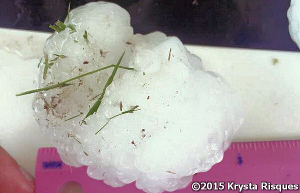 |
| In the picture: Hail bigger than baseballs (three inches in diameter) was measured at Hot Springs (Garland County) during the afternoon of 04/19/2015. The photo is courtesy of Krysta Risques via Twitter. |
|
| |
|
Monster hail hit again on April 19th. Baseball size hail (and slightly larger) was reported at Hot Springs (Garland County), with windows busted out of cars. Similar size hail pelted areas southeast of Caddo Gap (Montgomery County).
Earlier in the month (on the 9th), the largest hailstone of 2015 was collected in northeast Arkansas at Portia (Lawrence County). The stone was four and a half inches in diameter (about the size of a softball).
|
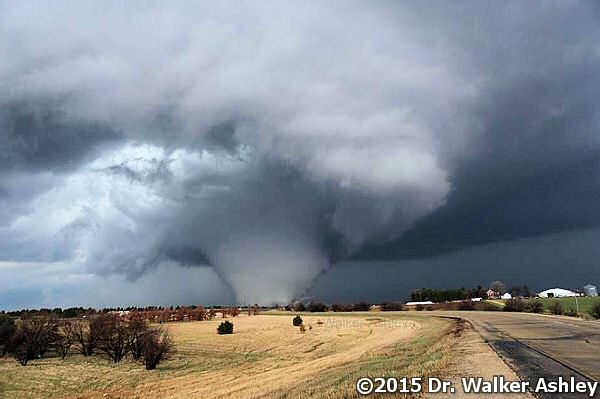 |
| In the picture: A large wedge tornado was noted near Rochelle, IL on 04/09/2015. The photo is courtesy of Dr. Walker Ashley via Twitter. |
|
| |
|
On the same day, one of the deadliest tornadoes in the spring was spawned. However, it did not happen in Tornado Alley (the Plains). This one tore through northern Illinois. The tornado (rated EF4) tracked from Rochelle to Belvidere (28.7 miles), and ripped through the towns of Fairdale and Kirkland (15 miles southeast of Rockford). Homes were heavily damaged or flattened, with two fatalities reported.
|
| The First Killer Tornado of 2015 in the U.S. |
|
A waterspout on Keystone Lake moved over land (rated EF2) and cut a swath through the west side of Tulsa, OK (near Sand Springs) on March 25th. The tornado took one life as it ripped through a mobile home park.
|
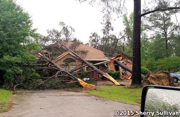 |
| In the picture: A tornado (rated EF2) uprooted and snapped trees onto this home at Nashville (Howard County) late on 05/10/2015. The photo is courtesy of Sherry Sullivan via Twitter. |
|
| |
|
Back at home, the only tornado that resulted in fatalities (2 of them) in 2015 spun up on May 10th near Nashville (Howard County) between 1115 pm and 1130 pm CDT. The tornado cut through a mobile home park and damaged 40 to 50 homes. It was the sixth tornado of the year in Arkansas.
|
|
|
| In the picture: Statewide precipitation ranks in May, 2015. The "120" in Arkansas means 120th driest (2nd wettest). The graphic is courtesy of the National Climatic Data Center (NCDC). |
|
| |
|
The biggest headline in May by far was the rain. There was so much of it. According to the National Climatic Data Center (NCDC), the monthly precipitation total for the country was 4.36 inches (1.45 inches above normal). This was the wettest May on record, and the wettest month of any month in the 121-years of record keeping.
In Arkansas, the statewide average of 10.35 inches (5.20 inches above normal) of liquid made it the second wettest May. This was a mere 0.68 inch behind the record set in 2009 (the wettest year on record locally).
|
| Wettest Mays on Record in Arkansas |
| Year |
Rain (Inches) |
| 2009 |
11.03 |
| 2015 |
10.35 |
| 1930 |
10.12 |
| 1968 |
9.75 |
| 1907 |
9.58 |
| Note: The statewide average precipitation in May is 5.15 inches. |
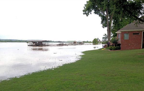 |
| In the picture: The Arkansas River was high at the River Plantation Subdivision in Mayflower (Faulkner County) on 06/02/2015. |
|
| |
|
The worst of the high water problems was along the Arkansas River. There were top 10 crests in the middle of the month and also during the last week. The latter crests were the highest since 1990 (at most forecast sites).
|
| Crests Along the Arkansas River |
| Location |
Crest (ft) |
Flood Stage (ft) |
Date/Time |
Rank |
| Ozark L & D (Franklin Co) |
367.71 |
357 |
05/27 (1 pm CDT) |
4 |
| Dardanelle (Yell Co) |
37.70 |
32 |
05/28 (10 am CDT) |
9 |
| Morrilton (Conway Co) |
38.50 |
30 |
05/29 (1230 am CDT) |
9 |
| Little Rock (Pulaski Co) |
22.20 |
23 |
05/31 (6 am CDT) |
11 |
| Pine Bluff (Jefferson Co) |
45.80 |
42 |
05/31 (7 pm CDT) |
5 |
|
The Red River in southwest sections of the state also got out of hand. Thousands of acres of farmland were flooded and livestock was evacuated. Bank erosion was extreme in Little River, Hempstead, Lafayette and Miller Counties. Bridges crossing the river along Highways 8, 71 and 259 were closed.
|
 |
| In the picture: Rainfall amounts across the southern United States in May, 2015. |
|
| |
|
While it was very wet around here, drought stricken areas of Oklahoma and Texas were also inundated with water (all-time wettest month in both states). The rain bucket collected 19.48 inches at Oklahoma City, OK, with foot to foot and a half amounts at Dallas, TX, Houston, TX and Tulsa, OK. When there is this much falling out of the sky, something has got to give. There were stories of tragedy in the two-state area, with at least two dozen lives lost to flooding. The Blanco River at Wimberley, TX (near Austin, TX) rose almost 35 feet in three hours late on the 23rd/early on the 24th. A wall of water swept away dozens of homes. Outside of Tulsa, OK, a firefighter was killed while performing a high water rescue at an apartment complex.
On the flip side, there was not much rain at all in portions of the Carolinas and Georgia. Only 0.32 inch fell at Charlotte, NC, with 1.23 inches at Savannah, GA and 1.71 inches at Columbia, SC (1.70 inches fell in one day, with 0.01 inch the rest of the month). It was a Top 5 dry May in Connecticut, Delaware, Massachusetts, New Jersey, Rhode Island, and South Carolina.
|
| |
| There is more concerning the year 2015 in Arkansas. To check out the rest of the story, click here. |
|
|