|
| Storm Reports |
| Are you interested in what happened during a recent event? Check out the report below. |
|
|
 |
Arkansas Yearly Climate Summary (2021)/Pg1 |
 |
| |
|
| 2021 Statistics |
| Month |
Tornadoes |
Tornado Deaths |
Wind (Tstm and Non-Tstm) Deaths |
Flood/Flash Flood Deaths |
Lightning Deaths |
| Jan |
0 |
0 |
0 |
0 |
0 |
| Feb |
0 |
0 |
0 |
0 |
0 |
| Mar |
8 (EF0: 4, EF1: 2, EF2: 2) |
0 |
0 |
0 |
0 |
| Apr |
3 (EF0: 1, EF1: 2) |
0 |
0 |
0 |
0 |
| May |
6 (EF0: 3, EF1: 3) |
0 |
0 |
0 |
0 |
| Jun |
4 (EF0: 2, EFU: 2) |
0 |
0 |
1 |
0 |
| Jul |
0 |
0 |
0 |
0 |
0 |
| Aug |
0 |
0 |
0 |
0 |
0 |
| Sep |
0 |
0 |
0 |
0 |
0 |
| Oct |
2 (EF0: 1, EF1: 1) |
0 |
0 |
0 |
0 |
| Nov |
0 |
0 |
0 |
0 |
0 |
| Dec |
12 (EF0: 4, EF1: 4, EF2: 2, EF4: 1, EFU: 1) |
2 |
0 |
0 |
0 |
| Total |
35 |
2 |
0 |
1 |
0 |
| Note: The yearly total of 35 tornadoes is slightly below the thirty year average of 37 tornadoes. The latest tornado (rated EF2) tore through Trumann (Poinsett County) on December 10th. The strongest tornado (rated EF4/maximum winds around 170 mph) tracked over 26 miles through Monette (Craighead County) and Leachville (Mississippi County) on December 10th. The tornado went another 54 miles or so through southeast Missouri and northwest Tennessee before finally dissipating to the northeast of Samburg, TN. Seven people were killed, with two fatalities in Arkansas. Across the state, this was one of only four tornadoes this strong since 2000. Two tornadoes in June and one in December were assigned ratings of EFU (unknown) because there was no damage to evaluate. |
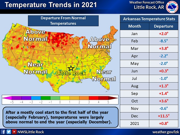 |
| Temperature Trends | Precipitation Trends |
| In the pictures: In 2021, above average temperatures (in red) and precipitation (in green) occurred in seven months. Overall, it was a little warmer and wetter than normal. |
|
| |
|
After three very wet years in a row (precipitation more than ten inches above average from 2018 through 2020), this year had rainfall much closer to what is expected. The first six out of seven months were wetter than usual, but the last four out of six months were dry to very dry. A drought was ongoing in central and southern Arkansas as 2021 ended.
|
| 2021 Extremes |
| Type of Extreme |
Extreme Reached/Date of Extreme |
| Hottest Temperature |
102° at Arkadelphia 2 N (Clark Co.) and Nimrod
Dam (Perry Co.) - Sep 2,
Hot Spring Airport (Garland Co.), Camden
Airport (Ouachita Co.), and Arkadelphia
Airport (Clark Co.) - Sep 1,
Blue Mountain Dam (Logan Co.) - Aug 25,
Morrilton (Conway Co.) - Aug 14,
Camden Airport (Ouachita Co.) - Aug 13 |
| Coldest Temperature |
-20° at Fayetteville Drake Field (Washington
Co.) - Feb 16 |
| Most Rain (Year) |
71.50" at Cane Creek State Park (Lincoln Co.) |
| Most Rain (Month) |
20.70" at Rohwer 2 NNE (Desha Co.) - Jun |
| Most Rain (Day) |
9.97" at Rohwer 2 NNE (Desha Co.) - Jun 9 |
| Least Rain (Year) |
35.69" at Omaha 2 S (Boone Co.) |
| Least Rain (Month) |
0.20" at Camden 1 (Ouachita Co.) - Sep |
| Most Snow (Year) |
31.2" at Harrison 10.6 SW (Boone Co.) |
| Most Snow (Month) |
20.7" at Harrison 10.6 SW (Boone Co.) - Feb |
| Most Snow (Day) |
14.2" at Arkadelphia 8.5 ESE (Clark Co.) - Feb 18 |
| Highest Snow Depth |
18" at Pine Bluff (Jefferson Co.), Hope 3 NE
(Hempstead Co.), Keo (Lonoke Co.), and Benton 10.9 WSW (Saline Co.) - Feb 18 |
|
As far as temperatures, readings were largely below average through the first half of the year, and warmer than normal during the second half. Two months stood out as extreme. It was very cold in February (the coldest since 1978), with average temperatures subpar by more than eight degrees. On the flip side, it was a blowtorch December, and the warmest on record (by almost three degrees).
|
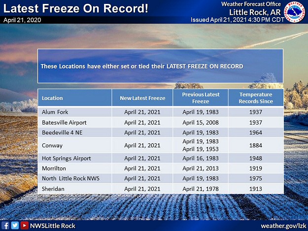 |
| In the picture: Latest freeze records were tied or broken at more than a half dozen sites in Arkansas on 04/21/2021. |
|
| |
|
Agriculturally, April stood out for an historic cold episode. Temperatures on the morning of the 21st were in the mid and upper 20s in the north/west, including at Batesville (Independence County), Clinton (Van Buren County), Fayetteville (Washington County), Flippin (Marion County), Highfill (Benton County), Mountain Home (Baxter County), Rogers (Benton County), Russellville (Pope County), Searcy (White County), and Siloam Springs (Benton County). It was the latest freeze on record at several sites, including Alum Fork (Saline County), Batesville (Independence County), Beedeville (Jackson County), Conway (Faulkner County), Hot Springs (Garland County), and the North Little Rock Airport (Pulaski County). Data goes back to 1937 at a couple of these locations, and all the way to 1884 at Conway (Faulkner County)!
|
| Damaging Wind and Hail in 2021 |
|
The strongest damaging wind gusts and largest hailstones were concentrated during two notable severe weather episodes on March 27th and May 3rd/4th.
During the afternoon and evening of March 27th, there was three inch diameter hail (slightly larger than baseballs) at South Bend (Lonoke County), baseball size hail at Gurdon and Whelen Springs (both in Clark County), and lime size hail at Newport (Jackson County) and Stuttgart (Arkansas County). These places are south/east of Little Rock (Pulaski County). Seven tornadoes (rated EF0 to EF2) also occurred.
On May 3rd/4th, there were several instances of 75 to more than 90 mph straight-line wind gusts across the northern and western counties. This included areas from Russellville to Atkins (both in Pope County), Bismarck (Hot Spring County) to Benton (Saline County), and Walnut Ridge (Lawrence County) to Paragould (Greene County). There were four tornadoes (rated EF0/EF1), with one of these tearing through the north side of Fort Smith (Sebastian County) and Van Buren (Crawford County).
|
|
|
| |
|
While 2021 will not be remembered for a lot of rain, there was a deluge of note across the southeast in June. Rohwer (Desha County) received 9.25 inches of rain in the twenty four hour period ending at 700 am CDT on the 8th. This was the most precipitation in one day at the site, and the fourth largest one day total across the state in June. If that was not enough, 9.97 inches of liquid was measured the next day! Adding the numbers, the whopping 19.22 inches on the 8th/9th was the second biggest two day amount in Arkansas. It was just behind the 21.45 inches at Danville (Yell County) on December 3-4, 1982. At Stuttgart (Arkansas County), 7.50 inches of rain fell on the 9th, which easily surpassed the previous one day June record of 4.07 inches on the 29th in 1939.
|
| Deluge in Central Arkansas |
|
During the evening of October 2nd, one thunderstorm after another moved over the same locations for several hours, and deposited five to over eight inches of rain from North Little Rock to Sherwood and Jacksonville (all in Pulaski County). At the North Little Rock Airport (Pulaski County), 5.78 inches of rain fell on the 2nd/early on the 3rd. This was the wettest twenty four hour period locally in October (dating back to 1975), and the fifth wettest such period all-time. Focusing on the 2nd alone, 5.25 inches of rain came down, which made it the second wettest calendar day (behind the high mark of 7.01 inches on November 18, 1988).
|
|
|
| In the video: Flooding was extensive at Dumas (Desha County) on 06/08/2021. The video is courtesy of Brian Emfinger via Twitter. |
|
| |
|
Way too much rain led to extensive flooding in the southeast. An economist with the Arkansas Agriculture Experiment Station estimated this event cost farmers at least $200 million in losses ($70 million each in soybeans and rice, and $60 million in corn).
|
| Precipitation in 2021 |
| Site |
Amount |
Normal |
+/- |
% of Normal |
| Fayetteville (NW AR) |
42.60 |
46.96 |
-4.36 |
91% |
| Harrison (NC AR) |
46.81 |
44.50 |
+2.31 |
105% |
| Jonesboro (NE AR) |
41.36 |
48.51 |
-7.15 |
85% |
| Fort Smith (WC AR) |
50.60 |
47.34 |
+3.26 |
107% |
| Little Rock (C AR) |
43.71 |
50.42 |
-6.71 |
87% |
| West Memphis (EC AR) |
44.66 |
50.40 |
-5.74 |
89% |
| Texarkana (SW AR) |
47.03 |
48.87 |
-1.84 |
96% |
| El Dorado (SC AR) |
49.27 |
52.12 |
-2.85 |
95% |
| Pine Bluff (SE AR) |
44.94 |
50.81 |
-5.87 |
88% |
| Note: The statewide average precipitation was 50.87 inches, or 1.26 inches above average. This was the 50th wettest year on record. |
| Average Temperatures in 2021 |
| Site |
Avg Temp |
+/- |
| Fayetteville (NW AR) |
59.0° |
+1.6° |
| Harrison (NC AR) |
58.9° |
+0.6° |
| Jonesboro (NE AR) |
61.3° |
+1.2° |
| Fort Smith (WC AR) |
63.1° |
+0.7° |
| Little Rock (C AR) |
62.9° |
+1.2° |
| West Memphis (EC AR) |
62.6° |
0.0° |
| Texarkana (SW AR) |
66.5° |
+2.5° |
| El Dorado (SC AR) |
64.2° |
0.0° |
| Pine Bluff (SE AR) |
64.4° |
+1.4° |
| Note: The statewide average temperature was 61.2 degrees, or 0.8 degree above average. This was the 32nd warmest year on record. |
|
Many if not all of the following events made the billion dollar list in 2021, and were mentioned in previous writeups on this website throughout the year.
|
| Arkansas and Beyond: Arctic Cold and Snow in February |
|
|
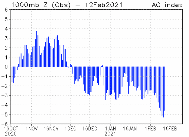
| In the picture: The Arctic Oscillation (AO) Index switched from positive to negative in December, 2020. The negative phase continued into early February, 2021. When the AO Index is strongly negative, especially for more than a few weeks, this implies that low pressure toward the North Pole (or the Polar Vortex) is weakening, and westerlies that carry cold air across Canada are not as strong. The cold air builds up and has no place to go except into the United States. |
|
| |
|
There were two reasons it got ridiculously cold in February. First, there was a long-term (more than two to three weeks) strongly negative Arctic Oscillation (AO) Index. This indicated that tropospheric low pressure (Polar Vortex) toward the North Pole was weakening, with frigid conditions bottled up in Canada and nowhere to go but here. Second, the Polar Vortex in the stratosphere (the next highest level in the Earth's atmosphere) rapidly declined in January. This was the straw that opened the floodgates and almost guaranteed tumbling temperatures.
|
|
|
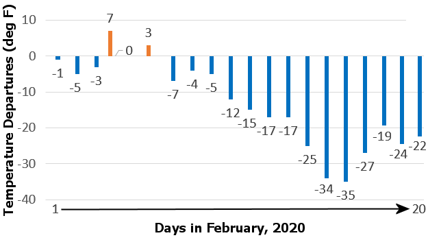
| In the picture: Temperatures were more than thirty degrees below average at times from February 14-20, 2021 at Little Rock (Pulaski County). |
|
| |
|
From the 10th through the 20th, temperatures across Arkansas were ten to more than thirty degrees below average. One of the coldest periods was the 15th into the 16th.
High temperatures on the 15th were mostly in the single digits and teens. It was 4 degrees at Fayetteville (Washington County), Harrison (Boone County), and Highfill (Benton County), and 6 degrees at Mountain Home (Baxter County).
There was clearing after dark, especially in the northwest. With snow cover, the mercury plummeted. The 16th started with well below zero readings in the northwest. It was -20 degrees at Fayetteville (Washington County)! Going back through records (using information from the experimental station on the north side of town), it was comparably cold on the morning of February 10, 2011. Otherwise, it had not been this much below zero since 1930. At Highfill (Benton County), it was -13 degrees, with -9 degrees at Harrison (Boone County) and Russellville (Pope County), and -8 degrees at De Queen (Sevier County) and Fort Smith (Sebastian County). Little Rock (Pulaski County) had -1 degree, which was the lowest reading since December 23, 1989.
Frozen pipes are a common concern in winter, and this became a huge problem in Mayflower (Faulkner County). Supply lines burst, and the city ran out of water. As a safeguard, many folks in central Arkansas were asked to conserve water as pipes thawed out and were subject to pressure breaks. Residents in cities such as Benton (Saline County), Hot Springs (Garland County), and Pine Bluff (Jefferson County) were urged to cut down on water usage due to a critically low supply.
|
| Tragedy and Hardship in Texas and Mississippi |
|
There was a tragic 130 vehicle pileup on an icy Interstate 35W on the north side of Fort Worth, TX that began just after 600 am CST on the 11th. At least six fatalities resulted.
Burst pipes and non-functioning water treatment plants (due to power outages) left nearly half of Texas (fourteen million people) without clean running water. Dry water taps in homes and a shortage of bottled water forced some people to boil snow for drinking or flushing toilets. In most major cities in the state, boil orders were in effect where water was available.
It was the same story for most folks in Jackson, MS. An aging infrastructure and brittle pipes were no match for well below freezing temperatures, snow, and ice. Water was not deemed safe and had to be boiled weeks after winter's wrath was over.
|
|
|
| |
|
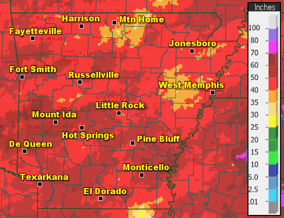
Two snowstorms on the 14th/15th and 17th/18th unleashed fifteen to more than twenty inches of snow in central and southern sections of the state. Five to fifteen inches was common farther north. Historically at Little Rock (Pulaski County), the February snow total of 20.3 inches was more than any other month (topping 20.0 inches in January, 1918), and made 2021 the third snowiest year (a foot less than the 32.6 inch record in 1960). The snow depth on the morning of the 18th was 15 inches, which was tied for first place in the record book (with January 21, 1918).
|
| |
| Let's check out more significant events in 2021 across Arkansas and nationally. For the rest of the story, click here. |
|
|