Interested in what kind of weather occurred in a recent year? Check out the most memorable events below.
Arkansas Yearly Climate Summary (2022)/Pg3
Outside of Arkansas
In the video: The satellite showed a massive eruption of the Hunga Tonga-Hunga Ha'apai volcano late on 01/14/2022 (between 1000 pm and 1110 pm CST).
In January, one of the largest volcanic eruptions in several decades (according to scientists) happened in the south Pacific Ocean late on the 14th. The Hunga Tonga-Hunga Ha'apai volcano coated nearby Tonga with a thick layer of ash, and sent tsunami waves thousands of miles away toward Japan and the western United States. In Arkansas, multiple social media posts from people with weather equipment showed quick pressure drops due to shockwaves from the eruption.
Another Volcano Becomes Active
On November 27th, the Mauna Loa volcano erupted. The volcano was in hiatus since 1985, which was its longest period (thirty seven years) without an eruption. This is one of five volcanos on the island of Hawaii.
On March 5, the #GOESEast ðŸ›°ï¸ captured imagery of multiple tornadic supercell thunderstorms as they raced across Iowa.
This visible channel imagery provides the finest spatial resolution available on the satellite's Advanced Baseline Imager. pic.twitter.com/uWf2Uts7EU
In the video: The satellite captured multiple tornadic supercells developing in Iowa on 03/05/2022.
Across the country, the deadliest tornado of 2022 cut a seventy mile path through four counties in Iowa on March 5th. This tornado was rated EF4, and had close to 170 mph winds as it reached Winterset, IA. Six people were killed, including four from the same family (a father, two children, and a grandmother). It was the first tornado of this magnitude in the state in nine years, and the second longest track since 1980. On the heels of the tornado, five inches of snow accumulated at Des Moines, IA on the 6th/7th.
On May 20th, a tornado (rated EF3/150 mph winds) ripped through Gaylord, MI. A mobile home park was obliterated, and there were two fatalities and more than forty injuries. It was the first deadly tornado across Michigan in a dozen years, and the strongest tornado in the state in ten years.
Other Notable Tornadoes
Two long track tornadoes (both rated EF4) carved through northeast Texas and southeast Oklahoma on November 4th. The first of these went from west of Paris, TX to southeast of Spencerville, OK (just to the east of Hugo Lake). This tornado pounded the Powderly, TX community, and was on the ground close to 45 miles. The second tornado left a 58 mile trail of destruction from southwest of Clarksville, TX to east of Broken Bow, OK. The town of Idabel, OK was especially hard hit.
Fatalities are most likely with higher end (versus weak) tornadoes. That was the case this time around, with a least two deaths linked to these tornadoes.
While lightning is not supposed to strike the same place twice, tornadoes sure did. On December 14th, a tornado (rated EF2/125 mph winds) damaged or destroyed numerous structures on the east side of New Orleans, LA (at Arabi, LA). Six people were injured. Anchored metal bleachers at a junior high school were ripped away, and the front facade of a grocery store was removed. A brewery was leveled for a second time in nine months after being reduced to rubble by another tornado (rated EF3/160 mph winds) on March 22nd. This was the strongest tornado on record in the metro area.
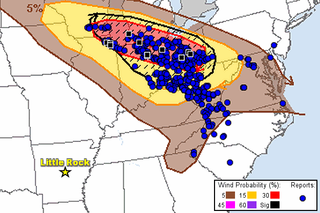
In the picture: Severe weather reports (mostly wind related) lined up well with a damaging thunderstorm wind outlook on 06/13/2022. The graphic is courtesy of the Storm Prediction Center.
A derecho (long-lived damaging straight-line wind event) pummeled areas from Toronto to Quebec City (a 500+ mile swath) with 60 to 90 mph gusts on May 21st. There were nine fatalities, mainly due to fallen trees. Nearly a million power outages were counted.
In mid-June, a derecho travelled from southern Wisconsin to Ohio on the 13th. An 84 mph gust occurred at Chicago, IL (at O'Hare International Airport) at 644 pm CDT. A little less than three hours and 150 miles later, an unprecedented 98 mph gust was measured at Fort Wayne, IN (at the International Airport) at 939 pm CDT.
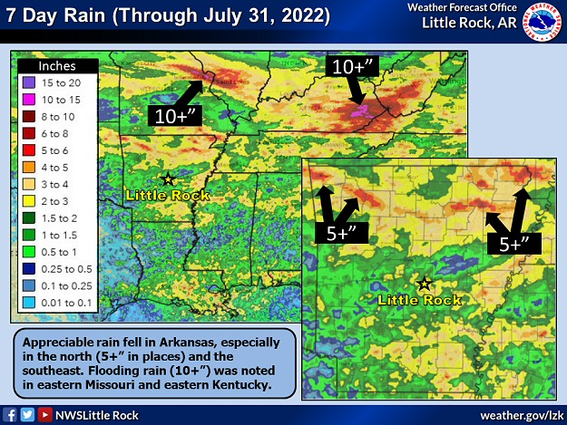
In the picture: Seven day rainfall through 7/31/2022. Portions of northern Arkansas had more than five inches of rain, with ten inches or more and extensive flooding in eastern Missouri and eastern Kentucky.
There was significant flooding in the St. Louis, MO area in July. Just over nine inches of rain fell in twenty four hours on the 25th/26th, and this broke the previous record by two inches (set in August, 1915 and due to the remnants of the Galveston Hurricane). Much of the rain (7.68 inches) came down in only six hours, which was faster than it could be carried away. Water flowed into homes and businesses and stalled vehicles. Dozens of people had to be rescued. There were two fatalities. High water closed a thirty mile section of Interstate 70 and damaged the MetroLink light rail transit system.
A couple of days later, there was a deluge in southeast Kentucky, with close to ten inches of rain in places. The North Fork Kentucky River went on a rampage through the rolling terrain of Appalachia. The river reached unfathomable levels at Whitesburg, KY (blowing by the previous record crest in 1957 by six feet) and Jackson, KY. A swollen Troublesome Creek ripped through Fisty, KY and Hindman, KY. As water levels rose, evacuations became necessary, including near Panbowl Lake Dam at Jackson, KY. Homes were swept off their foundations, and at least fifty bridges were washed away in one county. Thousands of people were displaced. Sadly, at least thirty seven people lost their lives. Adjacent areas of southwest Virginia and southwest West Virginia were also impacted by flooding.
More Flooding
Torrential rain fell in Dallas/Fort Worth, TX on August 21st/22nd. A whopping 9.19 inches of liquid fell, which was the second most twenty four hour amount on record locally (not far behind the 9.57 inch total on September 4th/5th, 1932). Even with an ongoing extreme drought (and sixty seven days with no measurable rain from June 4th through August 9th), there was a lot of flooding. Intersections became lakes, cars were submerged, and water flowed into homes/businesses. Three to four hundred people were rescued. A woman was killed when her vehicle was swept away by fast moving current.
On the 23rd/24th, a two day total of 8.58 inches of rain at Jackson, MS sent the Pearl River toward a Top 15 record crest. It was the wettest August day on record on the 24th, with 5.05 inches of precipitation tallied. Due to an overflowing river and other long term issues, the local water system failed. Officials scrambled to provide water for 180,000 people. In nearby Canton, MS, people were on top of their cars to escape rising water. Dozens of children were rescued at a day care center at Florence, MS. Water overwhelmed a nursing home in Brandon, MS, and at least three dozen residents were taken to safety. Northeast of Conehatta, MS, a portion of Highway 489 was completely washed away.
In the video: Major Hurricane Ian caused extensive damage in Fort Myers Beach, FL on September 28, 2022. The video is courtesy of Brian Emfinger via Twitter.
Hurricane Ian made landfall near Cayo Costa, FL as a Category 4 storm (150 mph sustained wind) during the afternoon of September 28th. Homes and businesses were destroyed in Fort Myers, FL, and an historic pier was ripped apart in Naples, FL. At both locations, a wall of water (storm surge) up to twelve feet moved ashore and set records. Ten to more than twenty inches of rain dumped in a narrow swath from Sarasota, FL to Daytona Beach, FL. So much rain turned neighborhood streets into lakes, and residents had to rescued by boat (including areas around Orlando, FL). Some rivers rose to unprecedented levels, including the Peace River at Arcadia, FL (topping out three to four feet above the previous high mark set in 1912). At least one hundred people were killed (mostly drowned), and two to three million utility customers were without power.
As Ian moved inland through Florida, the system weakened to a tropical storm. However, once the Atlantic Ocean was reached, Ian regained hurricane status. Hurricane Ian barreled toward the South Carolina coast as a Category 1 storm (85 mph sustained wind) on the 30th.
The Mud Island Marina home of the #Memphis Yacht Club which is surrounded by the Mississippi River has all the boats sitting in mud now. Record low levels on the #MississippiRiver are causing many different problems. pic.twitter.com/kXWIt378QE
In the video: The Mud Island Marina in Memphis, TN lived up to its name on 10/19/2022, with boats sitting in sludge due to record low water levels along the Mississippi River. It was a different story eleven years ago, with record high water levels occurring. The video is courtesy of Charles Peek via Twitter.
As drought conditions plagued the middle of the country in mid-October, barge traffic slowed way down because the mighty Mississippi River was losing volume. At Memphis, TN on the 18th, the river officially hit an all-time record low level of -10.79 feet, breaking the previous low mark of -10.70 feet set on July 10, 1988. While mass quantities of harvested crops are normally moved by barge up and down the river this time of year, this year's loads were lighter and fewer given a lack of water. Farmers were forced to store their crops locally, with the supply chain interrupted.
In Louisiana, the Army Corps of Engineers was constructing a massive underwater levee to keep salt water from heading northward along the Mississippi River. Over time, without a levee, salt water was expected to make headway into the river, with not enough flow to hold it back.
Fire, Heat, and Drought
About thirty miles northeast of Santa Fe, NM, two fires that merged in late April (into the Calf Canyon/Hermits Peak Fire) had torched 341,000 acres and close to 900 structures by the end of June. It was New Mexico's largest and most destructive wildfire.
Record heat occurred in the western United States in early September. On the 5th, the temperature reached 104 degrees at Salt Lake City, UT. It had never been so hot during September locally, and it was the 32nd day in 2022 with triple digit heat (a record number of occurrences in a year). The next day, the mercury hit 116 degrees at Sacramento, CA, and 109 degrees at San Jose, CA. It was the hottest day in recorded history at both sites.
On October 25th, drought covered 63 percent of the country (mostly the western and central United States). This was the most expansive drought footprint since 2012.
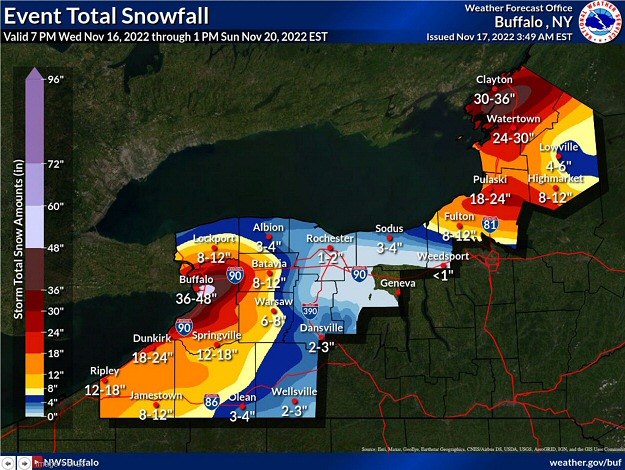
In the picture: The forecast called for at least three to four feet of snow at Buffalo, NY in a four day period ending at 100 pm EST on 11/20/2022. The forecast is courtesy of the National Weather Service in Buffalo, NY.
A long west to east fetch of cold air blowing over warmer water in Lake Erie and Lake Ontario triggered a massive lake effect snow event in western New York in mid-November. As of the evening of the 20th, ninety six hour snow accumulations were up to 80 inches at Orchard Park, NY. This is where a National Football League game was scheduled on the 20th, and had to be moved to Detroit, MI.
A month later, a blizzard paralyzed Buffalo, NY on December 23rd/24th. Just over forty inches of snow was measured in a two day period, along with a 72 mph gust and whiteout conditions. Tragically, the storm was responsible for close to forty fatalities in the city and surrounding areas. While it is surprising that so many deaths occurred in a location known for massive snow events, sources have cited several reasons for such a high death toll. First and foremost, the storm was so fierce that local officials were limited in what they could do to help those in need. Bare-bone holiday staffing did not help, with fewer officials available to offer assistance. Also, the timing of the event put people in harm's way trying to run last minute holiday errands. Others were on their way to work because a travel ban had yet to be declared. Finally, some folks viewed this as just another storm, and underestimated what turned out to be a life threatening situation.
A Lot of Snow in the Plains and New England
A blizzard crippled much of the northern Plains and upper Midwest in mid-December. Parts of the Dakotas, especially the Black Hills of western South Dakota, received up to four feet of snow. The snow was whipped around by winds over 50 mph. Over two feet of snow piled up in the Arrowhead of northeast Minnesota. There was also more than two feet of snow toward New England, mainly from northern and western New York to New Hampshire, Vermont, and Maine (including the Green and White Mountains).