|
| Storm Reports |
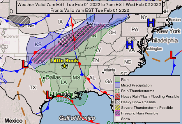
| Are you interested in what happened during a recent event? Check out the report below. |
|
|
 |
Arkansas Yearly Climate Summary (2022)/Pg1 |
 |
| |
|
| 2022 Statistics |
| Month |
Tornadoes |
Tornado Deaths |
Wind (Tstm and Non-Tstm) Deaths |
Flood/Flash Flood Deaths |
Lightning Deaths |
| Jan |
0 |
0 |
0 |
0 |
0 |
| Feb |
1 (EF0: 1) |
0 |
0 |
0 |
0 |
| Mar |
10 (EF0: 2, EF1: 6, EF2: 1, EF3: 1) |
0 |
0 |
0 |
0 |
| Apr |
10 (EF0: 5, EF1: 5) |
0 |
1 |
1 |
0 |
| May |
3 (EF0: 1, EF2: 1, EFU: 1) |
0 |
0 |
1 |
0 |
| Jun |
0 |
0 |
0 |
0 |
0 |
| Jul |
0 |
0 |
0 |
0 |
0 |
| Aug |
0 |
0 |
0 |
2 |
0 |
| Sep |
0 |
0 |
0 |
0 |
0 |
| Oct |
0 |
0 |
0 |
0 |
0 |
| Nov |
16 (EF0: 2, EF1: 10, EF2: 3, EFU: 1) |
0 |
0 |
0 |
0 |
| Dec |
0 |
0 |
0 |
0 |
0 |
| Total |
40 |
0 |
1 |
4 |
0 |
| Note: The yearly total of 40 tornadoes is slightly above the thirty year average of 37 tornadoes. The latest tornado (rated EF2) tore through areas just southeast of Sardis (Saline County) on November 4th. The strongest tornado (rated EF3/maximum winds around 145 mph) tracked about five miles from Johnson to Springdale (both in Washington County) on March 30th. Seven people were injured. Two tornadoes in May and November were assigned ratings of EFU (unknown) because there was no damage to evaluate. |
 |
| Temperature Trends | Precipitation Trends |
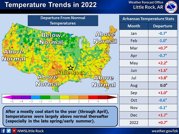
| In the pictures: In 2022, above average temperatures (in red) and precipitation (in green) occurred in six and seven months respectively. Overall, it was a little warmer and wetter than normal. |
|
| |
|
As far as temperatures in 2022, readings were a little warmer than average, especially during the late spring and early summer.
|
| 2022 Extremes |
| Type of Extreme |
Extreme Reached/Date of Extreme |
| Hottest Temperature |
109° at Gravette (Benton Co.) on Jul 26-27
108° at Booneville (Logan Co.) on Jul 19,
Flippin (Marion Co.) on Jul 20,
Fort Smith on Jul 19,
Morrilton (Conway Co.) on Jul 9,
Texarkana (Miller Co.) on Jul 9 |
| Coldest Temperature |
-10° at Compton (Newton Co.) on Dec 23
-9° at Clarksville 6 NE (Johnson Co.) on Dec 23,
Kingston 2 S (Madison Co.) on Dec 23,
Winslow 7 NE (Washington Co.) on Dec 23 |
| Most Rain (Year) |
66.34" at Big Fork 1 SSE (Polk Co.) |
| Most Rain (Month) |
15.53" at Moro Bay State Park (Bradley Co.) in Jul |
| Most Rain (Day) |
11.46" at Moro Bay State Park (Bradley Co.) on Jul 3 |
| Least Rain (Year) |
39.02" at Henderson 4 ENE (Baxter Co.)
40.15" at Flippin (Marion Co.) |
| Most Snow (Year) |
32.3" at Harrison 10.6 SW (Boone Co.)
32.0" at Lead Hill (Boone Co.) |
| Most Snow (Month) |
15.6" at Harrison 10.6 SW (Boone Co.) in Feb
14.5" at Lead Hill (Boone Co.) in Feb |
| Most Snow (Day) |
12.0" at Harrison (Boone Co.) on Jan 15 |
|
It was the 27th warmest May on record (2.2 degrees above average), and the 6th warmest July (3.8 degrees above average). Triple digit heat in July was one of the factors that led to a developing drought that lasted through the end of the year.
|
 |
| Precipitation | Departure From Normal | Percent of Normal |
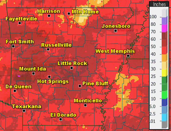
| In the pictures: The wettest conditions in 2022 were found from west central into central and northeast Arkansas, with the driest areas in the Ozark Mountains and the south. Overall, rainfall evened out to within one to two inches of normal. Note: Amounts in parts of the north (especially Fulton and Izard Counties) are underestimated. |
|
| |
|
The year started wet through the spring, but it quickly dried out in the summer/fall. Precipitation was largely subpar from June through October.
|
| What About Flash Flooding? |
|
Heavy to excessive rain was responsible for four fatalities in northwest Arkansas in 2022. On April 13th, the driver of a vehicle tried to cross a low water bridge along County Road 741 about four miles southeast of Berryville (Carroll County). The vehicle was swept downstream by an elevated Osage Creek, and the driver (a 70-year-old woman) was killed. During the early morning hours of May 5th, a 28-year-old woman was dropped off at an apartment complex in Fayetteville (Washington County). Near the complex, local authorities believe she was swept downstream by a swollen Town Branch Creek. Her body was found on the 13th. At Bentonville (Benton County) on August 29th, an 11-year-old boy was swept into a storm drain, as was a 47-year-old woman who tried to save him. While they were pulled from the drain and taken to a nearby hospital, both passed away.
|
|
It was the 10th driest September on record (2.33 inches below average), and the worst drought conditions of 2022 followed in early October.
|
| Precipitation in 2022 |
| Site |
Amount |
Normal |
+/- |
% of Normal |
| Fayetteville (NW AR) |
41.76 |
46.96 |
-5.20 |
89% |
| Harrison (NC AR) |
43.23 |
44.50 |
-1.27 |
97% |
| Jonesboro (NE AR) |
47.27 |
48.51 |
-1.24 |
97% |
| Fort Smith (WC AR) |
56.01 |
47.34 |
+8.67 |
118% |
| Little Rock (C AR) |
48.29 |
50.42 |
-2.13 |
96% |
| West Memphis (EC AR) |
53.17 |
50.40 |
+2.77 |
105% |
| Texarkana (SW AR) |
45.38 |
48.87 |
-3.49 |
93% |
| El Dorado (SC AR) |
50.41 |
52.12 |
-1.71 |
97% |
| Pine Bluff (SE AR) |
46.87 |
50.81 |
-3.94 |
92% |
| Note: The statewide average precipitation was 51.42 inches, or 1.81 inches above average. This was the 48th wettest year on record. |
| Average Temperatures in 2022 |
| Site |
Avg Temp |
+/- |
| Fayetteville (NW AR) |
59.2° |
+1.8° |
| Harrison (NC AR) |
58.5° |
+0.2° |
| Jonesboro (NE AR) |
61.0° |
+0.9° |
| Fort Smith (WC AR) |
63.0° |
+0.6° |
| Little Rock (C AR) |
64.0° |
+2.3° |
| West Memphis (EC AR) |
62.1° |
-0.5° |
| Texarkana (SW AR) |
66.9° |
+2.9° |
| El Dorado (SC AR) |
63.6° |
-0.6° |
| Pine Bluff (SE AR) |
64.3° |
+1.3° |
| Note: The statewide average temperature was 61.1 degrees, or 0.7 degree above average. This was the 39th warmest year on record. |
|
The following are some of the larger/most impactful events of 2022, and were mentioned in previous writeups on this website throughout the year.
|
| Across Arkansas: Winter Weather |
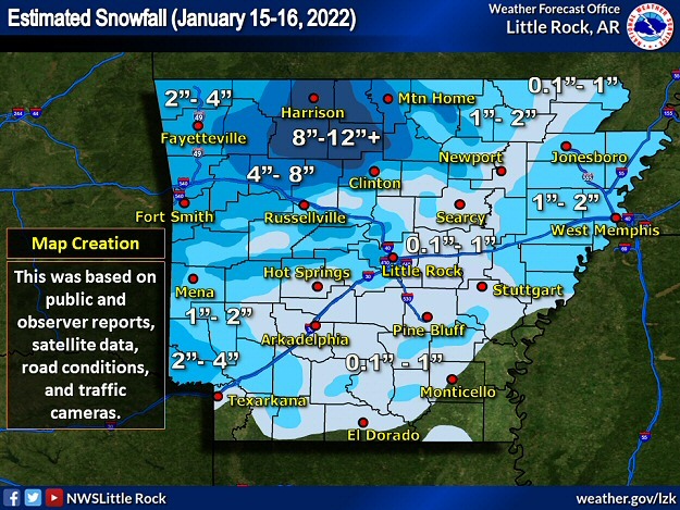 |
| In the picture: Snow accumulations in the twenty four hour period ending at 600 am CST on 01/16/2022. The heaviest snow (8 to more than 12 inches) was in the Ozark Mountains, especially in Boone, Marion, Newton, and Searcy Counties. |
|
| |
|
The year began with a big snowstorm in the Ozark Mountains of northwest Arkansas in mid-January. By the time the event ended (early on the 16th), Valley Springs (Boone County) had 14 inches of snow, with 13 inches a few miles south of Marshall (Searcy County), 12 inches near Canaan (Searcy County), Harrison (Boone County), and Pindall (Searcy County), and 11 inches at Lead Hill (Boone County) and Witts Springs (Searcy County).
In the Arkansas River Valley and Ouachitas, two to four inches of snow was measured at Clarksville (Johnson County), west of Dardanelle (Yell County), De Queen (Sevier County), Dover (Pope County), Fort Smith (Sebastian County), Mount Ida (Montgomery County), Subiaco (Logan County), and southwest of Wilton (Little River County).
|
|
|
| |
|
It was a mild start to February, with temperatures peaking in the 60s to lower 70s on the 1st. That came to a crashing halt the next day as an Arctic air mass made its way into the region from the northwest. Lots of moisture was available behind the front, and wintry precipitation became widespread. Heavy snow was in the forecast across northern into western sections of the state, with significant amounts of freezing rain and sleet farther south/east.
|
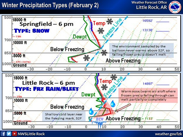 |
| In the picture: Soundings (temperature and dewpoint profiles with height) showed that snow was likely at Springfield, MO given an environment at/below freezing from the ground up at 600 pm CST on 02/02/2022. That was not the case at Little Rock, AR, with above freezing temperatures a few thousand feet aloft. Any snow would melt, and then refreeze in subfreezing air closer to the ground (resulting in freezing rain/sleet). |
|
| |
|
As daylight arrived by the morning of the 4th, Lead Hill (Boone County) had 13 inches of snow, with 11 inches north of Bella Vista (Benton County), near Norfork (Baxter County), and west of Viola (Fulton County), 10 inches near Flippin (Marion County), and 8 inches close to Fayetteville (Washington County), Harrison (Boone County), and north of Mountain Home (Baxter County).
Toward central Arkansas, one to more than three inches of sleet (and a little snow) was common. The southeast got the most freezing rain, with ice accruals of a half inch or more reported in spots from northwest of Monticello (Drew County) to De Witt (Arkansas County) and on toward Memphis, TN.
|
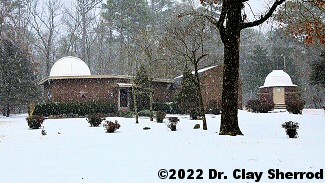 |
| In the picture: A period of heavy sleet (and some snow) was followed by freezing rain at Arkansas Sky Observatories at Petit Jean Mountain (Conway County) on February 23-24, 2022. By the time the event was over, walking was nearly impossible. The photo is courtesy of Dr. Clay Sherrod. Click to enlarge. |
|
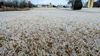 |
| In the picture: At the North Little Rock Airport (Pulaski County), this was largely a freezing rain event, with ice accruals just over a quarter inch on the trees and in the grass. Click to enlarge. |
|
| |
|
The northern and central counties were in for an ice storm (sleet and freezing rain) later in the month. On February 23rd/24th, Joy (White County) had 5 inches of sleet, with 4 inches at London (Pope County) and Searcy (White County), and 3 inches at Adona (Perry County), Bradford (White County), Fifty Six (Stone County), near Floyd (White County), Hackett (Sebastian County), Hartman (Johnson County), Judsonia (White County), Oppelo (Conway County), and Sidney (Sharp County).
|
|
|
| In the video: Freezing rain turned Highway 67 into a skating rink near Newport (Jackson County) on 02/24/2022. The video is courtesy of Charles Peek via Twitter. |
|
| |
|
Freezing rain accruals reached 0.75 inch at Cotton Plant (Woodruff County) and Mount Vernon (Faulkner County), 0.60 inch just east of Carlisle (Lonoke County), and 0.5 inch at Balch (Jackson County), Floral (Independence County), Greers Ferry (Cleburne County), Menifee (Conway County), Quitman (Cleburne County), Vilonia (Faulkner County), and Wynne (Cross County). More than 30,000 power outages were reported, with numerous outages in eastern Arkansas and in the Arkansas River Valley west of Little Rock (Pulaski County). This is where ice buildup on power lines was the most noteworthy, and where utility pole damage was the most extreme.
Whenever there is ice, travel can become a nightmare. One prime example happened during the morning of the 24th along Highway 67 at Newport (Jackson County). Not only were there numerous accidents, driving conditions were so treacherous that vehicles stopped in the middle of the road (a parking lot). Eventually, the highway was shut down.
|
|
|
| In the video: A weather balloon was launched with snow falling (and accumulating) at the North Little Rock Airport around 500 pm CST on 03/11/2022. |
|
| |
|
On March 11th, heavy snow was focused toward the central third of the state, and was accompanied by thunder in places. While it generally lasted six hours or less, a lot of locations had several inches of heavy wet slush. Near Wynne (Cross County), 7 inches of accumulation was reported, with 5 to 6 inches at Perryville (Perry County), and 5 inches at Bismarck (Hot Spring County), Ferndale (Pulaski County), Morrilton (Conway County), and West Memphis (Crittenden County).
|
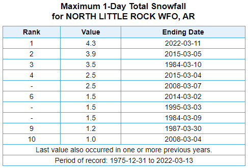 |
| In the picture: At the North Little Rock Airport (Pulaski County), the 4.3 inches of snow on 03/11/2022 was the heaviest one day March accumulation on record (dating back to 1975). |
|
| |
|
At the North Little Rock Airport (Pulaski County), there had never been so much snow in one day in March (dating back to 1975). The official measurement of 4.3 inches topped the previous monthly record of 3.9 inches on the 5th in 2015. Note that the event in 2015 set the high mark for the most snow in a twenty four hour period (spread over two days), with 6.3 inches of powder on the 4th/5th.
|
| Snow in November |
|
After well above average temperatures through the first ten days of November, it turned sharply colder. Light snow developed in far northern Arkansas on the 11th/12th, with half inch to inch accumulations toward the Missouri border. At Mammoth Spring (Fulton County), three inches of powder was reported.
There was more snow on the 14th/15th, mainly in the Ozark Mountains. Four to five inches of flakes piled up a few miles southwest of Hogeye (Washington County). Four inches of snow was tallied at Greenland, Strickler, and West Fork (all in Washington County). Three to four inches of snow accumulated at Winslow (Washington County), with three inches at Compton (Newton County), southeast of Kingston (Madison County), southwest of Marshall (Searcy County), and northeast of Weathers (Madison County).
A final round of snow on the 18th resulted in a dusting in the northwest, but it was enough to coat bridges/overpasses. Numerous accidents were reported in portions of Benton and Washington Counties, mainly along Interstate 49. The highway was closed temporarily to treat the pavement.
|
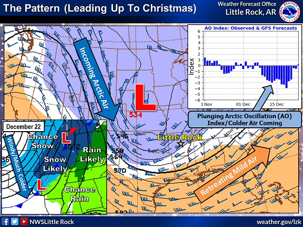 |
| In the picture: A blast of Arctic air arrived from the Plains on 12/22/2022. This was due to a blocking pattern, with a strongly negative Arctic Oscillation (AO) Index serving as an indicator. By blocking, it is meant that cold air did not flow as freely across Canada (i.e. blocked), and was forced to the south. There were areas of light snow, especially in northern Arkansas. |
|
| |
|
Later in 2022, after above average temperatures during the first half of December, there were signs that Arctic air would visit Arkansas before Christmas. That promise was realized on the 22nd, and in a big way!
|
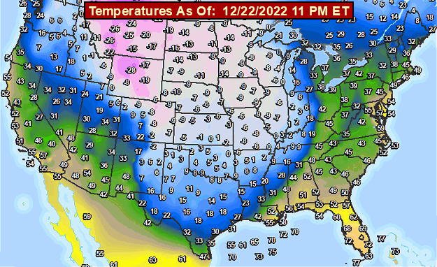 |
| In the picture: Subfreezing air surged all the way to the Gulf Coast by the late evening of 12/22/2022. |
|
| |
|
The day started with temperatures in the 30s and 40s, but that changed in a hurry. Dangerously cold air poured into Arkansas, and readings plummeted more than thirty degrees at many locations in less than six hours.
As temperatures plunged, northwest winds picked up markedly. Gusts from 35 to 45 mph were common across the region. This created wind chill index values from 15 to 30 below zero in much of northern and central Arkansas. These conditions continued through the overnight hours of the 22nd and early on the 23rd. One to more than two inches of snow fell across mainly the northern two to three rows of counties.
By the morning of the 23rd, low temperatures were below zero in northern Arkansas, and in the single digits farther south. Some of the coldest readings included -10 degrees at Compton (Newton County), -9 degrees at Jasper (Newton County), -8 degrees at Devils Knob (Johnson County), -6 degrees at Harrison (Boone County) and Rogers (Benton County), and -5 degrees at Lead Hill and Omaha (both in Boone County).
|
| Not the First Time in December |
|
Back in 1983, an historic Arctic blast kept temperatures below freezing in Little Rock (Pulaski County) for a record 308 hours from December 18th through the 31st. The Arkansas River froze over as a result. In 1989, another round of Arctic air dropped the temperature below zero (-1 degree) without snow on the ground on the 23rd. There were four straight mornings (21st through the 24th) with readings below 10 degrees.
|
| |
| Let's check out more significant events in 2022 across Arkansas. For the rest of the story, click here. |
|
|