 |
| About This Page |
| Arkansas has had its share of historic events, many of which will be in our memories for years to come. |
|
|
 |
Deadly Flooding on April 29-30, 2017 |
 |
| |
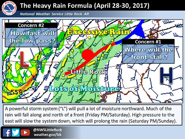 |
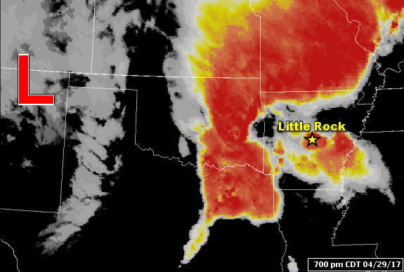
| In the picture: Flooding rain hinged on the placement of a warm front pushing through Arkansas from the south and the speed of a storm system ("L") approaching from the west on 04/29/2017. |
|
| |
|
Heading into the last few days of April, there had not yet been a massive rainfall event during the spring. However, conditions were looking very favorable for more than a half foot of rain in parts of Arkansas. The event revolved around a warm front lifting through the area from the south, and a storm system wobbling this way from the southern Plains.
|
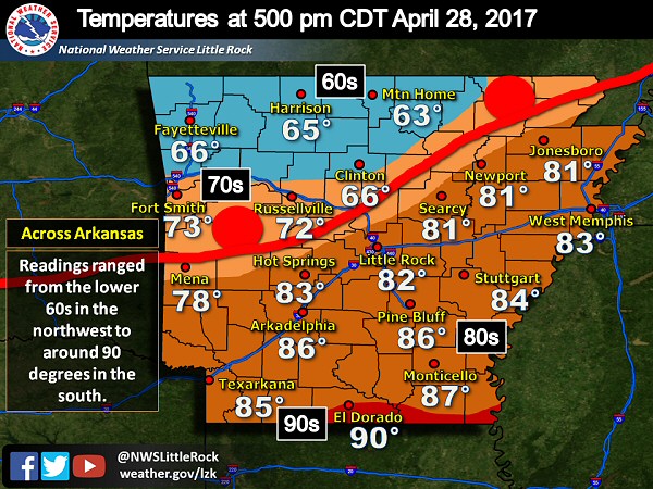 |
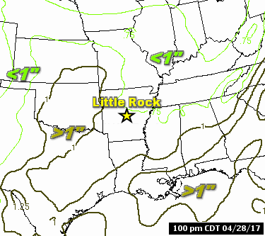
| In the picture: A warm front made it through all but northwest Arkansas (from the south) by 500 pm CDT on 04/28/2017. Readings ranged from the lower 60s north of the front to around 90 degrees to the south. |
|
| |
|
The warm front had gone through the central and southern counties by the late afternoon of the 28th. Very warm and humid air was found south of the front. This air mass was expected to lift over the front into northern sections of the state, with massive amounts of precipitation resulting.
|
|
|
The available moisture in place was incredible. In fact, the atmosphere contained at least double the usual moisture, with storms eventually wringing this out as torrential downpours.
|
| In the pictures: Precipitable water (PWAT), or water vapor contained in a vertical column of the atmosphere, climbed to close to double the average by 100 pm CDT on 04/29/2017. Values were as high as 1.59 inches at the North Little Rock Airport (Pulaski County) by 700 pm CDT. Typically in late April, values are between 0.75 inch and 1.00 inch. |
|
|
| |
|
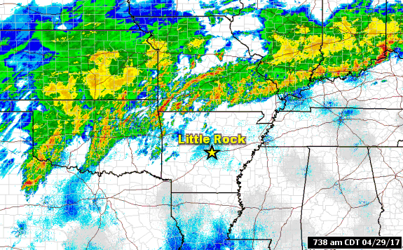
Fortunately, the front pushed far enough to the north to keep the bulk of the rain in Kansas, Missouri, and Oklahoma through the morning of the 29th. There was a deluge in far northwest Arkansas, and this was going to be the story for the remainder of the region heading into the afternoon and evening.
|
| Severe Storms |
|
This event also featured severe weather. Just before 600 pm CDT, damaging straight-line winds knocked a tree onto a mobile home at DeWitt (Arkansas). A woman inside the mobile home was killed.
At least nine weak tornadoes (rated EF0/EF1) were confirmed. One of these tornadoes tore through locations near Bellefonte (Boone County) between 300 pm and 330 pm CDT on the 29th. The front of a house was pushed in, with serious damage resulting. Shortly before 500 pm CDT, another tornado damaged a home and destroyed a mobile home north of Natural Dam (Crawford County). Between 1230 am and 100 am CDT on the 30th, sheds and metal buildings were ripped up by a tornado a couple of miles north of Griffithville (White County). Huge trees were also uprooted or snapped. Other tornadoes were identified south of Augusta (Woodruff County), between Datto and Corning (both in Clay County), southwest of Humnoke (Lonoke County), near Happy Corners (Mississippi County), Dell (Mississippi County), and north of Pleasant Grove (Drew County). All of these happened during the wee hours of the 30th.
Power outages became a problem due to high winds and a tremendous amount of lightning. More than 70,000 customers lost power.
|
|
|
| |
|
As the storm system to the west limped toward us, a wall of water slowly spread to the east. Not only was there a lot of rain, there was some severe weather.
|
|
|
| |
|
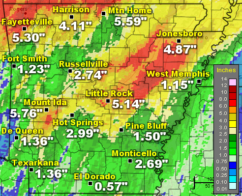
As far as reported rainfall, parts of the northwest and central into northeast sections of Arkansas were hammered with over six inches of rain. It was two months of rain in only a day.Twenty four hour amounts through 700 am CDT on the 30th included a whopping 9.73 inches near Rogers (Benton County), 8.50 inches at Savoy (Washington County), 7.85 inches at Guy (Faulkner County), and 7.82 inches at Georgetown (White County). Numerous roads were under water, with water into homes, and people rescued from houses and vehicles due to rising water.
At least seven people were killed as flooding became extreme. Near Hindsville (Madison County), a car carrying two small children (4-year-old boy and 18-month-old girl) was pushed off the road. Their bodies were eventually recovered. At Eureka Springs (Carroll County), a young woman was inner tubing in a drainage ditch and disappeared under a bridge. According to reports, her body was found a half mile downstream. A 10-year-old girl fell into a creek at Springdale (Washington County), and was swept downstream. Also in Washington County, the body an elderly man was found in a car that had been submerged in water. In West Little Rock (Pulaski County), a woman's body was discovered in Rock Creek. She was supposedly camping in a tent, and went missing when the water came up. Finally, northwest of Paron (Saline County), a group of people in kayaks were challenged by currents along Alum Fork south of Lake Winona. One man was killed.
|
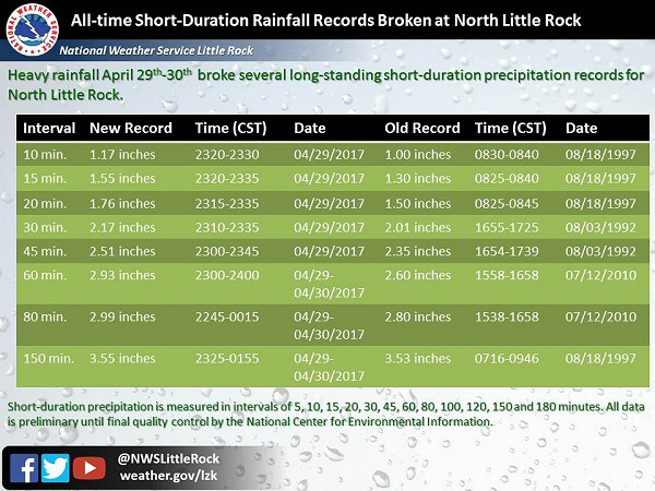 |
| In the picture: Short duration rainfall records were broken at the National Weather Service in North Little Rock (Pulaski County) in the two-and-a-half hour period ending at 255 am CDT on 04/30/2017. |
|
| |
|
At the North Little Rock Airport (Pulaski County), rain came down in buckets, and at a record pace. A staggering 1.55 inches of water fell 15 minutes, with 2.17 inches in 30 minutes.
|
 |
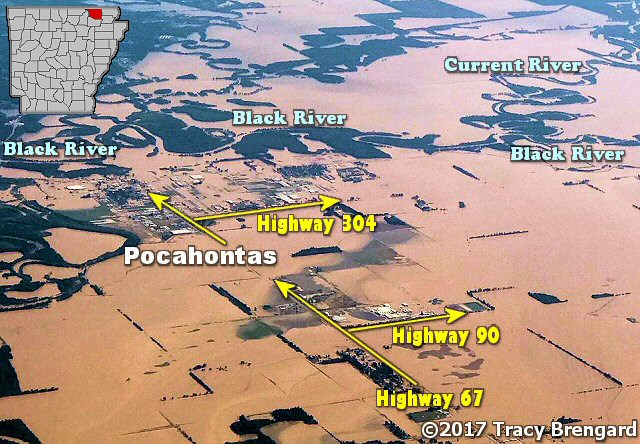
| In the picture: A record crest of 29.0 feet occurred along the Black River at Pocahontas (Randolph County) on 05/02/2017. |
|
| |
|
Given way more liquid than the ground could hold, area tributaries swelled heading into early May. Moderate to major flooding occurred along the Black, White, and Cache Rivers (northern and eastern Arkansas).
A record crest of 29.0 feet was reached along the Black River at Pocahontas (Randolph County) on May 2nd (breaking the previous record of 28.5 feet in late April, 2011). Prior to this unprecedented rise, evacuations were ordered on the east side of town, and Highway 67 was shut down.
|
| Not Just the Black River |
|
The Current River runs out of southern Missouri into northern Arkansas, and flows into the Black River just east (upstream) of Pocahontas (Randolph County). Twenty five miles away at Doniphan, MO, the Current River crested at 33.13 feet on May 1st. This was well above the previous high mark of 26.80 feet on March 1, 1904. The flow rate was an exceptional 183,000 cubic feet per second (CFS), dwarfing the usual trickle of 2,000 to 3,000 CFS. This tremendous and historic amount of water was injected into the Black River, and was a huge contributor to the flooding that occurred locally.
|
 |
Flooding at Pocahontas (Randolph County) | Flooding at Georgetown (White County)
Boating to Work from Georgetown (White County) |
| In the pictures: Pocahontas (Randolph County) and surrounding areas were inundated with water from an overflowing Black River (and failed levees along the river) on 05/03/2017. This is looking north from Walnut Ridge (Lawrence County). As the White River climbed steadily at Georgetown (White County), Highway 36 went under water. Because this was the only road out of town, people were forced to travel via boat. The photos are courtesy of Tracy Brengard (via Twitter), Ron Snyder (via Facebook), and Debra Lang (via Facebook) respectively. |
|
| |
|
On the 3rd, the river started dropping as a local levee failed in multiple spots. This led to imminent and widespread flooding in parts of Lawrence and Randolph Counties. A Flash Flood Emergency (mentioning "an extremely dangerous and life-threatening situation") was issued by the National Weather Service in Memphis, TN at 831 am CDT.
|
|
In the days to follow, the White River overflowed. At Georgetown (White County), a stretch of Highway 36 became a lake, and the town became an island. Extensive sandbagging took place at Des Arc (Prairie County) and Clarendon (Monroe County) to help keep some homes and businesses dry. According to the the University of Arkansas System Division of Agriculture, water engulfed more than 950,000 acres of cropland (in 21 of 75 counties), causing over $175 million in losses (especially to rice, soybeans, and corn).
|
| There were numerous reports of heavy rain, flooding, and severe weather (damaging winds, hail, etc) on April 29th and 30th (early). For a look at the reports, click here.
|
|
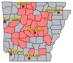
| In the picture: Preliminary reports of heavy rain, flash flooding, and severe weather in the Little Rock County Warning Area on April 29-30, 2017 (in red). |
|
|