 |
| About This Page |
| Arkansas has had its share of historic events, many of which will be in our memories for years to come. |
|
|
 |
Severe Weather on February 5, 2008 (Pg2) |
 |
| |
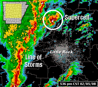 |
By the late afternoon of the 5th, tornadic supercells (storms with rotating updrafts) were followed by a squall line along the front...with strong to damaging winds. |
| In the picture: The WSR-88D (Doppler Weather Radar) showed a tornadic supercell (storm with rotating uprafts) near Clinton (Van Buren County) with a squall line moving into central Arkansas at 536 pm CST on 02/05/2008. |
| At Hot Springs (Garland County), there was a 53 mph gust at 605 pm CST...and a 67 mph gust at Little Rock Adams Field (Pulaski County) at 713 pm CST. |
| After the front and squall line exited eastern sections of the state (by 10 pm CST), much colder air followed. Moisture wrapped around the storm system, with light snow toward the Missouri border early on the 6th. |
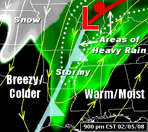 |
| In the picture: The pattern as of 9 pm CST on 02/05/2008...with a cold front sweeping through Arkansas with strong to severe thunderstorms. The front was followed by much cooler air. |
| Damage Surveys/Pictures |
 |
The National Weather Service at Little Rock (Pulaski County) surveyed tornado damage caused on the 5th. |
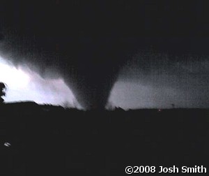
| In the picture: A tornado approached Clinton (Van Buren County) from the southwest toward sunset on 02/05/2008. The photo is courtesy of Josh Smith. |
| One long track tornado was confirmed, with a track length of 122 miles. An aerial survey was performed (with the Civil Air Patrol) on the 9th to determine if the path was continuous...and it was! |
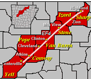 |
| In the picture: A tornado rated EF4 tracked through portions of Yell, Pope, Conway, Van Buren, Stone, Izard and Sharp Counties on 02/05/2008. |
|
The starting point of the tornado was 5.6 miles east-southeast of Centerville (Yell County). It finally dissipated 3.2 miles northeast of Highland (Sharp County).
The rating for the tornado was initially at least an EF3. A member of a Quick Response Team (QRT) visited Arkansas on the 8th to look at some of the worst damage along the track. In the end, the rating was upgraded to EF4.
|
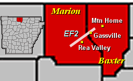 |
Damage in Baxter and Marion Counties (caused by a separate storm) was evaluated...and was caused by a tornado rated EF2. |
| In the picture: A tornado rated EF2 tracked through portions of Marion and Baxter Counties on 02/05/2008. |
| The starting point of the tornado was 4 miles west-southwest of Rea Valley (Marion County). It dissipated 3 miles west-southwest of Mountain Home (Baxter County)...a path length of 14 miles. |
| Coordinate File of Tornadoes |
| |
|
The National Weather Service in Little Rock received several requests for data that shows exactly where tornadoes tracked on the 5th. Several teams from the office obtained this data on the road (ground surveys), in the air (aerial survey), and through interviews with people affected by the storm. A KMZ (compressed KML) file was constructed using points visited by the teams. The points were plotted using mapping software. Many of the points have a damage rating (EF0 to EF4) and descriptions of damage...and there are some pictures available.
|
| Link of Interest |
| Coordinate File of Tornado Tracks: KMZ |
| Note: This file is for use with GIS software such as Google Earth. |
| There was widespread severe weather (including tornadoes) on February 5, 2008. For a look at some reports, click here. |
|
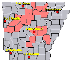
| In the picture: Preliminary reports of severe weather in the Little Rock County Warning Area on February 5, 2008 (in red). |
|
|