Are you interested in what happened during a recent event? Check out the report below.
Severe Storms on February 9, 2024
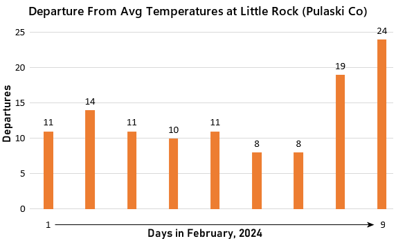
In the picture: Temperatures were well above average at Little Rock (Pulaski County) from February 1-9, 2024.
It was a very mild start to February, and especially on the 9th. Temperatures were 15 to 25 degrees above average! Moisture increased ahead an incoming storm system and cold front in the Plains. While there was some risk of thunderstorms in the afternoon/evening, one storm in particular went haywire.
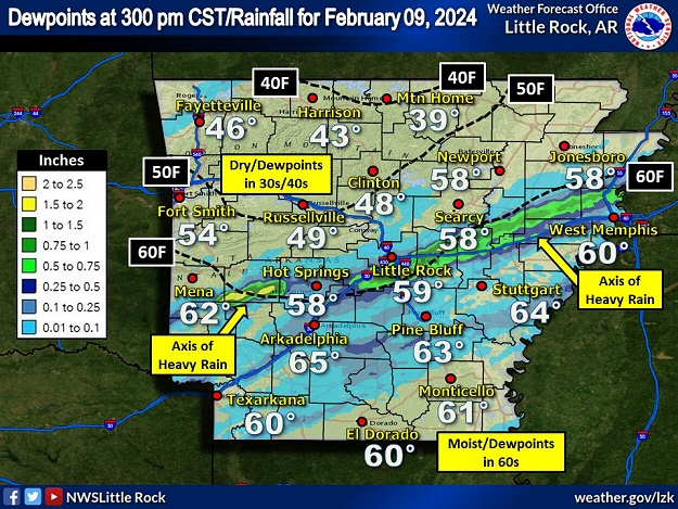
In the picture: There was a narrow axis of heavy rain (1 to 2 inches in spots) across the central third of Arkansas on 02/09/2024. Severe storms followed this axis during the late afternoon/early evening. This was between a dry air mass to the north (dewpoints in the 30s/40s), and a moisture laden environment farther south (dewpoints in the 60s).
The storm developed in the Ouachita Mountains (west central sections of the state) and tracked to the east through Montgomery, Garland, and Saline Counties.
In the video: The WSR-88D (Doppler Weather Radar) showed a severe storm tracking from west to east through Garland and Saline Counties in central Arkansas during the late afternoon/early evening of 02/09/2024. Hail to the size of tennis balls was produced initially. As the storm collided with other isolated showers/storms (moving from southwest to northeast), the focus shifted from hail to tornadoes.
Along the way, large hail was produced initially. Half dollar size hail was reported at Royal (Garland County) around 515 pm CST. Fifteen minutes later, there was tennis ball size hail on the north side of Hot Springs (Garland County).
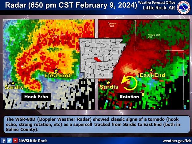
In the picture: The WSR-88D (Doppler Weather Radar) showed classic signs of a tornado (hook echo, strong rotation, etc) at 650 pm CST on 02/09/2024 as a supercell (storm with rotating updrafts) tracked from Sardis to East End (both in Saline County).
Between 600 pm and 630 pm CST, the storm collided other isolated showers/storms moving from southwest to northeast toward Benton (Saline County). Once this happened, the potential for hail dropped markedly.
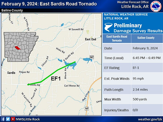
In the picture: A weak tornado (rated EF1) was confirmed between Sardis and East End (both in Saline County) on 02/09/2024.
However, once the collisions commenced, the storm that survived showed signs of rotation. As the circulation tightened/strengthened just east of Sardis (Saline County), a tornado was spawned at 645 pm CST.
While there were trees obstructing the view, here is a photo of a possible tornado (can't see contact with the ground) near East End (Saline Co) around 653 pm CST this evening. There was damage reported in the area (trees/power lines downed). #arwxhttps://t.co/pRAq7X9x2K
In the picture: A tornado was witnessed near East End (Saline County) around 653 pm CST on 02/09/2024. The photo is courtesy of Steven Freeman and provided by Julianna Cullen via X (formally Twitter).
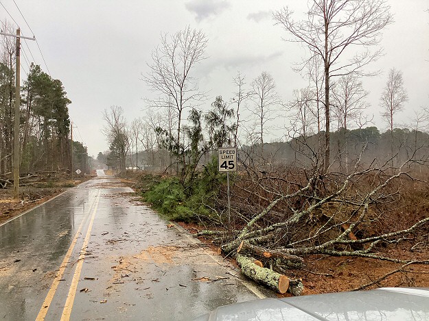
The tornado (rated EF1) uprooted/snapped trees and downed power lines along its two to three mile trek toward East End (Saline County). The trees blocked several roads.
In the pictures: Tree debris was cleared from roads and utility lines and poles were repaired roughly one to two miles east-southeast of Sardis (Saline County) following a weak tornado (rated EF1) on 02/09/2024.
Damage to structures was mostly due to fallen trees and tree limbs. There was some minor roof damage to homes, sheds, and outbuildings. After the tornado dissipated, there was no additional severe weather noted.