|
| Storm Reports |
| Are you interested in what happened during a recent event? Check out the report below. |
|
|
 |
Spotty Severe Storms/Heavy Rain on March 4-5, 2024 |
 |
| |
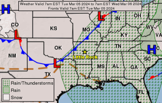 |
| In the picture: A cold front approached from the Plains on 03/04/2024, and arrived the next day. Ahead of the front, there were isolated instances of severe storms and heavy/excessive rain. |
|
| |
|
As March began, it certainly felt like spring. On the 4th, afternoon temperatures were largely in the mid 70s to lower 80s, and a cold front was set to push into Arkansas from the Plains. Scattered thunderstorms popped up ahead of the front, and several storms were severe.
|
|
|
| In the picture: There were a few reports of large hail and damaging thunderstorms winds on March 4-5, 2024. |
|
| |
|
Hail to the size of ping pong balls was reported a few miles southeast of Jonesboro (Craighead County). Half dollar size hail pelted Altheimer (Jefferson County) and just southwest of Trumann (Poinsett County). Trees were downed at Dumas (Desha County) and near Parkin (Cross County).
|
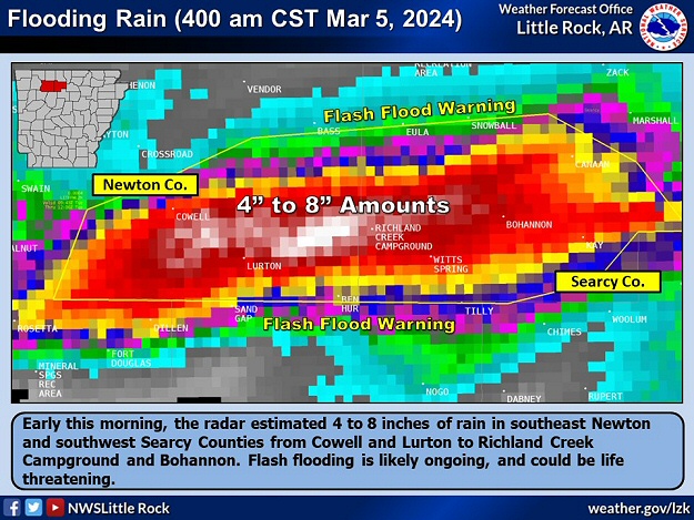 |
| In the picture: The radar estimated 4 to 8 inches of rain in southeast Newton County and southwest Searcy County early on 03/05/2024. A Flash Flood Warning was issued as a result. |
|
| |
|
During the predawn hours of the 5th, a heavy rain episode took place. There was a deluge in southeast Newton County and southwest Searcy County, with thunderstorms moving over the same locations for several hours. Radar estimated more than a half foot of precipitation in spots!
|
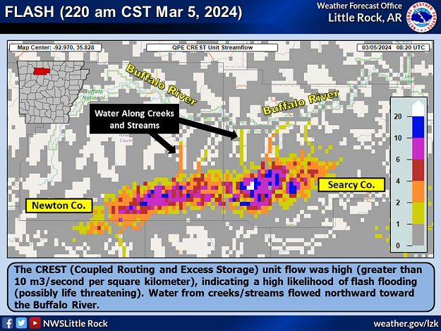 |
| In the picture: The CREST (Coupled Routing and Excess Storage) unit flow was high (greater than 10 m3/second per square kilometer) early on 03/05/2024, indicating a high likelihood of flash flooding (possibly life threatening). Water from creeks/streams flowed northward toward the Buffalo River. |
|
| |
|
Data suggested this was becoming a dangerous situation, so Flash Flood Warnings with "life threatening" wording were disseminated. Given the remoteness of the affected area and the time of morning, there was no word of anything major happening.
|
|
|
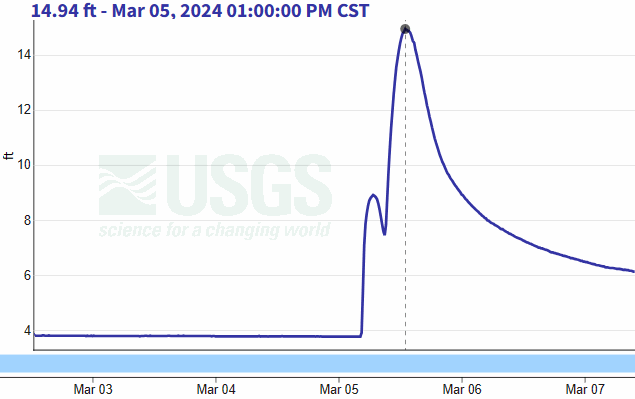
| In the picture: The Buffalo River at St. Joe (Searcy County) rose more than 10 feet on 03/05/2024. This was due to heavy/excessive rain that fell 15 to 20 miles away (to the south/southwest), and carried by creeks/small streams toward the tributary. |
|
| |
|
However, a surge of water headed northward on Richland Creek. The flow along the creek jumped from less than 30 cubic feet per second to close to almost 17,000 cubic feet per second. This was not much different than the flow of the Arkansas River at that time! Water from the creek made it into the Buffalo River, and the level at St. Joe (Searcy County) went from just under 4 feet to almost 15 feet by early afternoon.
Before the Buffalo River responded, and as dawn approached on the 5th, isolated severe storms made an appearance in northwest Arkansas. Not far from Chester (Crawford County), quarter size hail was noted.
|
|
|