 |
| About This Page |
| Arkansas has had its share of historic events, many of which will be in our memories for years to come. |
|
|
 |
Tornado Outbreak (March 1, 1997) |
 |
| |
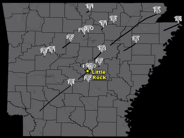 |
| In the picture: Seventeen tornadoes were spawned on March 1, 1997. The deadliest tornadoes tracked along Interstate 30 from Arkadelphia (Clark County) to Little Rock (Pulaski County). |
|
| |
|
On March 1, 1997, 17 tornadoes were spawned in Arkansas...killing 25 people. Since this event, no weather episode has resulted in as many fatalities locally. Note: The deadliest tornado outbreak in state history occurred on March 21, 1952 (111 deaths).
|
| Unusually Strong Tornadoes |
|
There were three tornadoes during this event rated F4. These happened between 200 pm and 700 pm CST (or five hours). From 2000 to 2020, there were equally as many tornadoes rated as high. The Super Tuesday long track (122 mile) tornado of February 5, 2008, the Etna-Denning tornado of May 25, 2011, and the Mayflower-Vilonia tornado of April 27, 2014 were the three EF4 tornadoes during this twenty one year span.
|
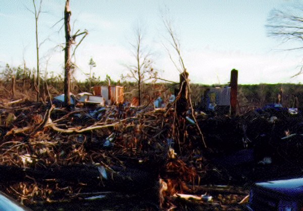 |
Destroyed Home Near Vimy Ridge (Saline County)
Destroyed Home at College Station (Pulaski County) |
| In the pictures: A home was dismantled by a tornado (rated F4) near Vimy Ridge (Saline County) on 03/01/1997. A short while later, the same tornado flattened a home at College Station (Pulaski County). Behind the latter home was a church that was hit during choir practice (20 to 30 participants). Nobody in the church was injured. The photos are courtesy of Chris Smith, National Weather Service Southern Region Headquarters. |
|
| |
|
This was a larger than normal outbreak, and the nature of the tornadoes was unusual. More specifically, tornado damage paths are normally a few miles long...but some of these damage tracks were 50 to 75 miles in length. The vast majority of tornadoes are weak...but these tornadoes caused considerable damage.
In all, at least 1200 structures were damaged or destroyed during the event...with property damage estimated over $115 million.
The air was very unstable the 1st, with warm and humid air surging northward from the Gulf of America. Normal daytime high temperatures in the Little Rock area should be in the upper 50s...but readings were in the mid 70s at noon.
|
| A strong cold front moved into the state from the northwest...with temperatures in the 30s, 40s and 50s behind the front in much of Oklahoma, Kansas, and Missouri. Given such a temperature contrast across the front, the atmosphere was very unstable. |
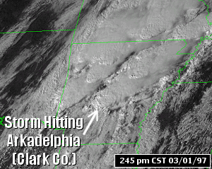 |
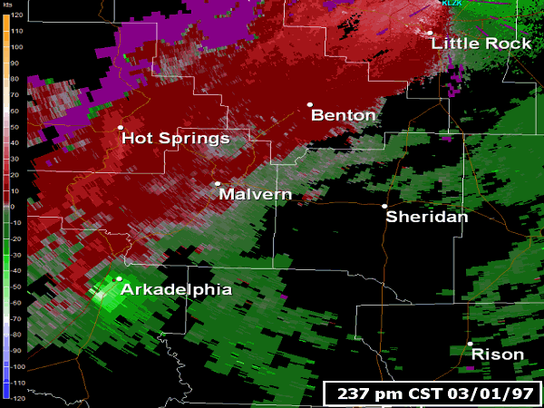
| In the picture: The satellite showed a thunderstorm moving over the Arkadelphia (Clark County) area around 245 pm CST on 03/01/1997. The storm spawned a large tornado (rated F4). |
 |
The wind near the ground and aloft was also very strong...with some directional shear noted. |
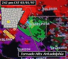
| In the picture: The WSR-88D (Doppler Weather Radar) showed strong rotation at Arkadelphia (Clark County) at 242 pm CST on 03/01/1997. |
|
|
| |
|
In other words, the wind turned with height...with a south breeze at 10 to 20 mph near the ground and a southwest wind over 50 miles an hour at 5000 feet. Such a turning motion caused rotation in the atmosphere...and more of a threat for tornadoes.
|
| The National Weather Service in Little Rock issued 57 severe weather warnings during the event, and 34 of these were Tornado Warnings. |
| Prominent Tornadoes |
| |
|
There were two prominent tornadoes in the Little Rock County Warning Area on March 1st. Both tornadoes were spawned by the same parent storm (dubbed the "Interstate 30 Supercell"), and were rated F4.
One tornado tracked from two miles northeast of Hope (Hempstead County) through Arkadelphia (Clark County) to four miles east of Malvern (Hot Spring County). The track length was 67 miles! Considerable damage was noted in Arkadelphia (Clark County) and Donaldson (Hot Spring County). Six people were killed in and around Arkadelphia (Clark County).
The other tornado tracked from three miles southeast of Benton (Saline County) through Little Rock (Pulaski County)...and dissipated four miles east of the city. The track length was 27 miles. The tornado devastated the Shannon Hills (Saline County) community...and also the south side of Little Rock (Pulaski County). This includes College Station (Pulaski County) and areas around Dixon Road and Arch Street Pike. Ten people were killed in Saline County, with five people losing their lives in Pulaski County.
Another long track tornado (rated F3) affected areas from 10 miles northeast of Searcy (White County) to Jacksonport (Jackson County) before tracking into the Memphis County Warning Area. The track length was 75 miles...the longest of the day! Three people were killed in Jackson County (two near Denmark and the third at Jacksonport). Another death was reported in Greene County.
|
|
|