 |
| About This Page |
| Arkansas has had its share of historic events, many of which will be in our memories for years to come. |
|
|
 |
Ice Storm on January 26-28, 2009 (Pg2) |
 |
| |
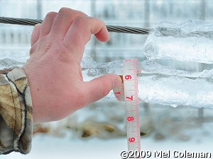 |
Of course, it takes a lot of moisture to create so much ice...and liquid totals were impressive. |
| In the picture: This ice in Fulton County (northern Arkansas) had a 6 inch circumference, which is just short of a 2 inch diameter. The photo is courtesy of Mel Coleman. Click to enlarge. |
| Twenty four hour precipitation through 6 am CST on the 28th included 4.41 inches at Fort Smith (Sebastian County), 4.10 inches at Fayetteville (Washington County), 3.55 inches at Harrison (Boone County) and 2.78 inches at Mountain Home (Baxter County). All totals were estimated. |
 |
| In the picture: Twenty four hour precipitation through 6 am CST on 01/28/2009. "E" is estimated. |
 |
| In the pictures: Winter warnings and advisories for heavy snow and ice extended from Texas and Arkansas into the Ohio Valley and New England as of 11 pm CST on 01/27/2009. |
|
| |
| The storm system to the west arrived late on the 27th/early on the 28th. Colder air wrapped around the system, with rain briefly becoming freezing rain and sleet in the central counties and portions of the south. Eventually, all precipitation changed to light snow before ending. |
 |
One to two inches of snow accumulated across the north, with less than an inch (generally a dusting) elsewhere. |
| In the picture: Snow accumulations through 6 am CST on 01/28/2009. |
| Precipitation ended quickly during the morning of the 28th, and the sun broke out at times. Even so, temperatures remained below freezing in northern Arkansas throughout the day...which hampered cleanup efforts. |
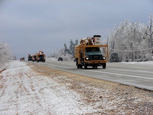 |
| In the picture: A convoy of utility trucks was headed into northern Arkansas along U.S. Highway 167 between Velvet Ridge (White County) and Pleasant Plains (Independence County) on 01/28/2009. Click to enlarge. |
|
|
Widespread heavy icing occurred across northern Arkansas on January 26-27, 2009. To check some reports, click here. |
| In the picture: Preliminary reports of wintry precipitation in the Little Rock County Warning Area on January 26-27, 2009 (in red). |
|
|