 |
| About This Page |
| Arkansas has had its share of historic events, many of which will be in our memories for years to come. |
|
|
 |
Ice Storm on January 26-28, 2009 (Pg1) |
 |
| |
|
|
A cold front stalled along the Gulf Coast on the 24th/25th, with cold and dry conditions north of the front in Arkansas.
|
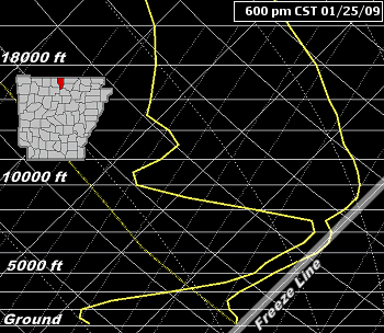
| In the pictures: The sounding, or temperature (solid yellow line to right) and dewpoint (solid yellow line to left) profile with height, showed the atmosphere moistening at Mountain Home (Baxter County) through 6 pm CST on 01/26/2009. More specifically, temperature and dewpoint differences became minimal (solid yellow lines came together). Also, above freezing conditions were noted above ground (causing precipitation to melt)...with below freezing readings near the ground (precipitation refreezing). This yielded freezing rain/sleet. |
| A storm system approached from the southern Rockies and southern Plains. The system drove moisture northward over the front, with precipitation breaking out late on the 26th/early on the 27th. It was cold enough for areas of freezing rain and sleet across northern and central Arkansas. |
| Weather Conditions on 01/27/2009 |
| Below are some observations from a trained spotter located 3 miles north-northeast of Mountain Home (Baxter County). |
12:00 am CST...Moderate Sleet / Freezing Rain / Light Snow
3:00 am CST...Moderate Freezing Rain / Light Sleet
6:00 am CST...Heavy Freezing Rain
8:17 am CST...Heavy Freezing Rain and Thunder
Additional Note: Small branches breaking off, power brown outs, power lines lowering.
9:30 am CST...Light Freezing Rain and Thunder
12:00 pm CST...Light Freezing Rain
2:45 pm CST...Moderate Freezing Rain
Additional Note: Moderate limbs snapping, power failure.
4:00 pm CST...Moderate Freezing Rain
Additional Note: Moderate and large limbs snapping, restored power with brown outs.
6:00 pm CST...Moderate Freezing Rain
7:30 pm CST...Light Freezing Rain and Thunder
Additional Note: Very large limbs and whole trees snapping, total power failure.
9:00 pm CST...Heavy Freezing Rain
11:40 pm CST...Heavy Freezing Rain / Snow / Light Sleet
Additional Note: Very large limbs and trees snapping, power lines falling to the ground and on home. No power. Structural damage to home and shed. |
| In the south, above freezing air kept precipitation mostly in the form of rain. Steady or slowly rising temperatures occurred through the morning of the 27th. |
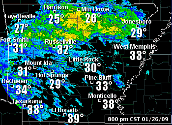 |
| In the picture: The WSR-88D (Doppler Weather Radar) showed mainly freezing rain spreading across the northwest half of Arkansas at 8 pm CST on 01/26/2009. |
 |
On the 27th, freezing rain continued in the north. It warmed up just enough (lower to mid 30s) in central sections for a changeover to rain, with patchy light rain across the south.
|
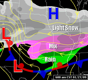
| In the picture: Moisture ahead of a system system ("L") in the southern Rockies encountered cold air surrounding high pressure ("H") in Iowa at 6 am on 01/27/2009. The result was mixed precipitation across the center of the country. |
| Readings could have climbed a lot more, but the cold air was well entrenched across the region. How much more? Just across the line in northern Louisiana, both Monroe and Shreveport hit 74 degrees. |
| Temperatures on January 26-27, 2009 |
| Site |
6p (26th) |
10p (26th) |
2a (27th) |
6a (27th) |
10a (27th) |
2p (27th) |
| Fayetteville (NW AR) |
27° |
28° |
31° |
31° |
32° |
E31° |
| Harrison (NC AR) |
24° |
25° |
30° |
27° |
30° |
31° |
| Jonesboro (NE AR) |
30° |
30° |
32° |
32° |
32° |
31° |
| Fort Smith (WC AR) |
29° |
32° |
33° |
33° |
E33° |
E34° |
| Little Rock (C AR) |
29° |
30° |
31° |
32° |
33° |
35° |
| West Memphis (EC AR) |
37° |
34° |
32° |
33° |
35° |
35° |
| Texarkana (SW AR) |
33° |
34° |
34° |
33° |
34° |
35° |
| El Dorado (SC AR) |
38° |
38° |
40° |
37° |
38° |
40° |
| Monticello (SE AR) |
38° |
37° |
37° |
34° |
36° |
38° |
| E - Estimated temperature |
| Because it stayed cold, one to two inches of ice (and locally more) accumulated on trees and power lines in roughly the northern two rows of counties. This was the worst icing since December, 2000. |
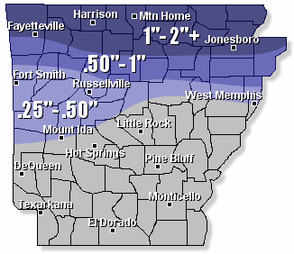 |
| In the picture: Storm total ice amounts through 6 am CST on 01/28/2008. While accruals were minimal across much of central Arkansas, quarter to half inch amounts occurred in elevated areas. |
 |
By 3 pm CST on the 27th, an estimated 150,000 customers were without power in these areas. That eventually increased to 350,000 customers. |
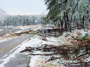
| In the picture: Tree damage was extensive across northern Arkansas due to the weight of the ice. This road was blocked by tree debris about 2 miles south-southwest of Evening Shade (Sharp County) on 01/30/2009...or two days after the ice storm ended. Click to enlarge. |
|
The dire situation was summed up by Mel Coleman, CEO of North Arkansas Electric Cooperative, to those working to restore power (on the night of the 27th):
"In all of my years I have never seen anything that compares to the damage this storm has caused. From the beginning forecasts yesterday morning it seemed the worst could happen, but we tried to believe it wouldn't happen. It did happen. I am sure your service areas look a lot like ours...I have yet to see a mature tree standing that was not severely damaged. Just opening the door to the outside sounds like a war zone, with the continuous sounds of trees and limbs breaking...like gunshots over the next hill. At this point we have no idea as to the extent the distribution system has been damaged, but it has to be bad...bad. My closing thoughts for the night: I sincerely hope that each of you make it through this disaster stronger than when you went in. This event will take everything we have...from our spirit to our never ending dedication to our members...to get us through this. It will take days and possibly weeks...but it will come together. Good luck, stay safe & hang in there."
|
|
The process of restoring power was slow. At least 30,000 utility poles were downed or snapped during the event, and it takes a crew a couple of hours to replace one pole. Through February 3rd, there were still 100,000 customers in the dark.
As many as eighteen fatalities were reported across the state. Most of these were due to hypothermia, post-event hazards (i.e. downed trees/power lines) or traffic related. For example, the police chief in Trumann (Poinsett County) was killed by a falling ice covered tree branch. Hypothermia claimed the life of an elderly woman in Piggott (Clay County). The power was out, and she apparently tried to stay warm by filling her bathtub with hot water (which cooled over time).
|
| |
| There is more concerning the ice of January 26th through the 28th. To check out the rest of the story, click here. |
|
|