|
Since snowfall records began in Little Rock (Pulaski County), there have been relatively few times when snow occurred on Christmas Day.
Looking at the entire period of record from 1875 to 2023, snow fell a dozen times (measurable four times and flurries or trace amounts the other eight times). In three other years (in 1876, 1963 and 2004), no snow fell, but there was measurable snow already on the ground.
Going by the averages, there is snow in the air or covering the ground on Christmas about once every nine to ten years. It is much more rare to have snow start on Christmas and accumulate (more than a trace on the ground) before the end of the day. It happened in 2012 (9.0 inches). Before that, it was 1926!
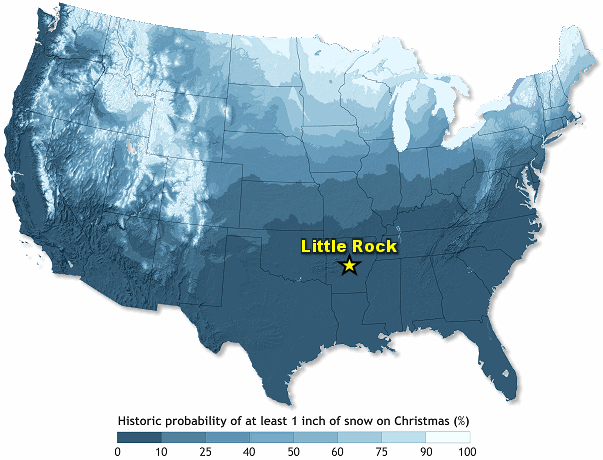 |
| In the picture: Odds of a white Christmas across the United States (at least one inch of snow on the ground). |
|
| |
|
|
| |
| Some Details About Past White Christmases at Little Rock |
| |
In 1887...1914...1918...1935...1939...1975 and 2009 snow fell with no accumulation.
In 1876...two inches of snow was on the ground from snowfall on Christmas Eve.
In 1879...rain began around 7 am Christmas Eve...changing to a mix of sleet and snow during the afternoon. By night...the ground was covered with snow...which continued into Christmas morning.
In 1897...one inch of snow fell on Christmas Day between 450 am and 1245 pm. By 700 pm that night...only a trace of snow remained on the ground.
In 1913...snow started at midnight and continued until 1130 am Christmas Day. A total of one and one half (1.5) inches of snow fell...but during the afternoon the temperature rose to 40 degrees and most of it melted. By that evening only a trace of snow remained.
On Christmas Day in 1926...sleet began falling around 600 am and then changed to snow. The snow continued until 130 pm. Overall...there was 1.7 inches of sleet and 2.5 inches of snow. The snow stayed on the ground through the 28th. Ironically...there was a serious tornado outbreak in Arkansas on Thanksgiving that year.
On Christmas Eve in 1962...it snowed an inch and a half (1.5) during the day but melted quickly during the night...leaving only patches of snow on the ground Christmas morning...which melted that day.
In 1963...four inches of snow was on the ground Christmas Day...left over from a 9.8 inch snowfall on December 22.
In 1975...it snowed on Christmas afternoon. In many of the hills around the city up to two inches of snow accumulated. For those living in the lower elevations of the city...rain and snow was mixed and little of the snow remained on the ground. By the next day...most of the snow had melted.
In 1983...a total of 2 inches of snow fell earlier in the week and there was some ice on top of that. Due to melting and refreezing...there was about an inch of ice and snow left on the ground by Christmas Day...but none remained on the ground at the observing site.
In 1990...2.4 inches of snow and sleet fell on December 22-23 and most of it remained on the ground through Christmas Day in some of the higher elevations of the metro area.
| |
| In 2000...there was some snow on the ground in northern and western Arkansas on Christmas Day. In the capital city...a trace of sleet and freezing rain had accumulated on the ground. That day...one of the largest ice storms in recorded history overspread the state...shutting the state down through the remainder of the year. |
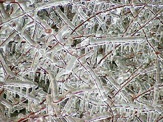 |
| In the picture: Exposed objects were coated in a thick layer of ice at the North Little Rock Airport (Pulaski County) in late December, 2000. |
| |
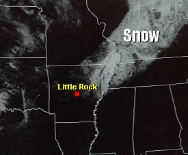 |
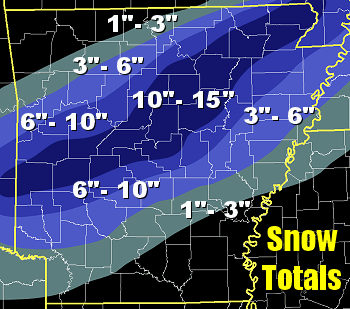
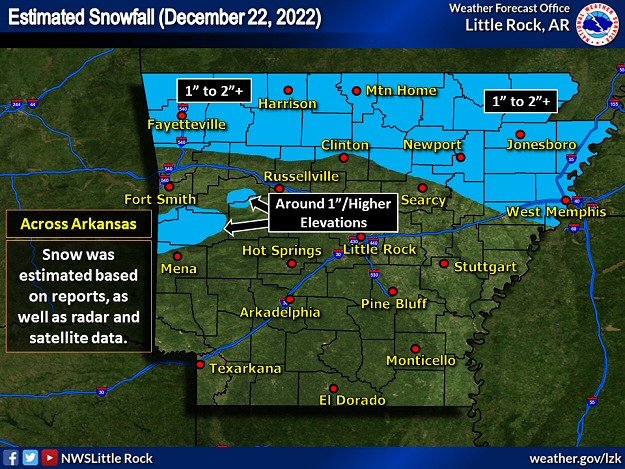
In 2004...snow fell in much of northern and central Arkansas on December 22. In the capital city, roughly 3 inches of snow was measured...with 1 inch still on the ground on Christmas Day. |
| In the picture: The satellite showed snow on the ground from Arkansas into the Ohio Valley on 12/27/2004. |
| |
In 2009...light snow began a little before midnight on Christmas Eve. It ended around 300 am Christmas morning...with patches of snow on the ground through early morning.
In 2012...rain and freezing rain developed during the late morning and continued in the afternoon. There was also thunder at times. Precipitation changed to sleet and then snow during the evening, and there were still a few rumbles of thunder. By midnight, nine inches of snow was measured.
|