
Heat expands across the Desert Southwest, Plains, Mississippi Valley and Midwest into Monday. Fire weather concerns continue for portions of the Intermountain West. Active monsoonal moisture fuels thunderstorms over the Southwest with possible flash flooding. Tropical cyclone Fausto in the Pacific, should weaken as it approaches Hawaii; Dangerous surf, swells and rip currents are expected. Read More >
Overview
|
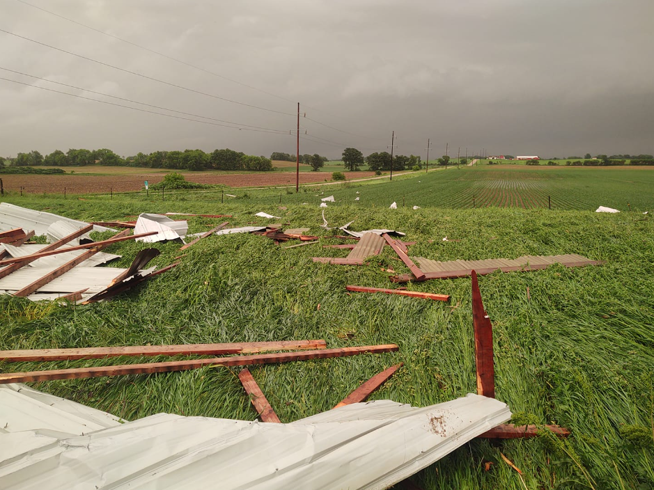
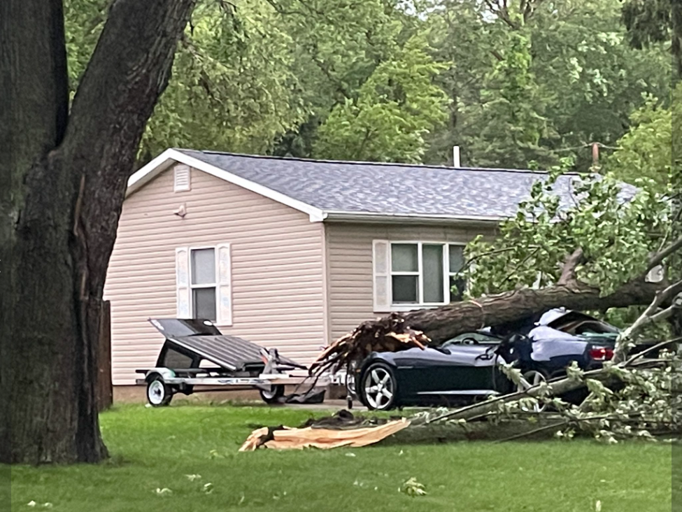
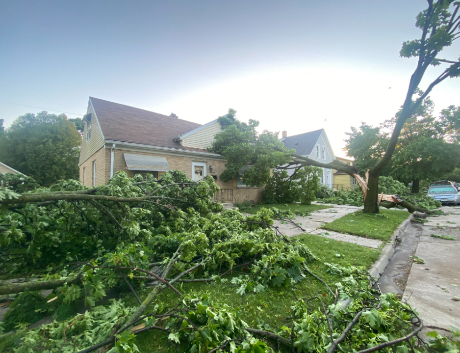
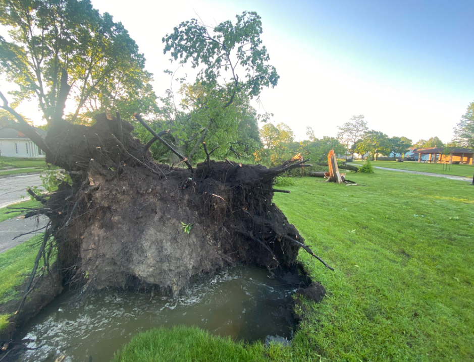
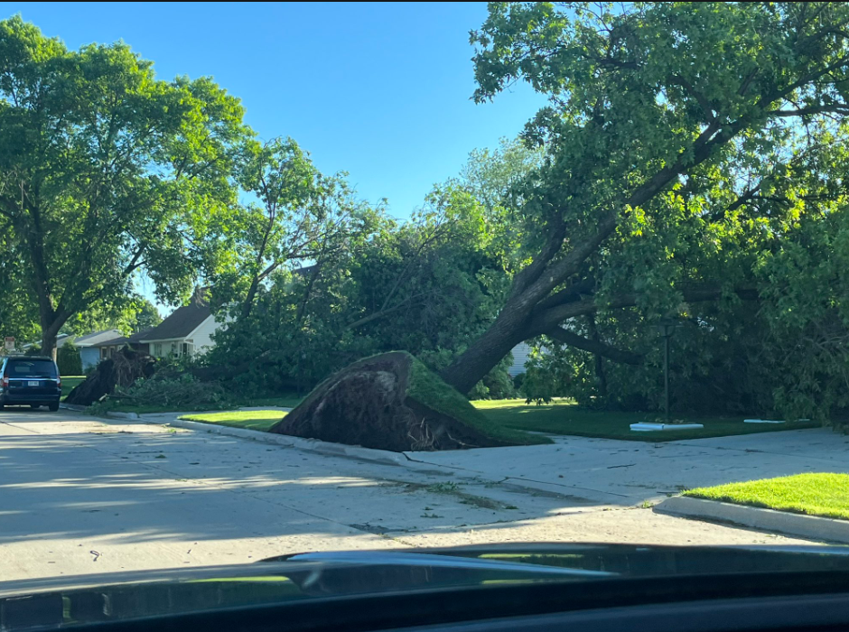
During the afternoon and evening of June 15, 2022, severe thunderstorms developed along a cold front in western Wisconsin and tracked eastward across the state. Many storms were severe and a few produced tornadoes in western and northeast Wisconsin. These thunderstorms created a swath of wind damage that extended from northeast Iowa all the way into northeast Wisconsin. As the storms moved into southeastern Wisconsin they slowed down and brought heavy rainfall. Our NWS damage survey determined that winds in the hardest hit areas in Marquette County were straightline winds around 90 to 105 mph. Winds in Dane, Columbia and Dodge counties were straightline and estimated to be around 70 mph. Several other areas across southern Wisconsin had damage as the result of winds around 50 to 70 mph.
Below is a summary of the event for areas in southern Wisconsin within the jurisdiction of the Milwaukee/Sullivan Weather Service Office. |
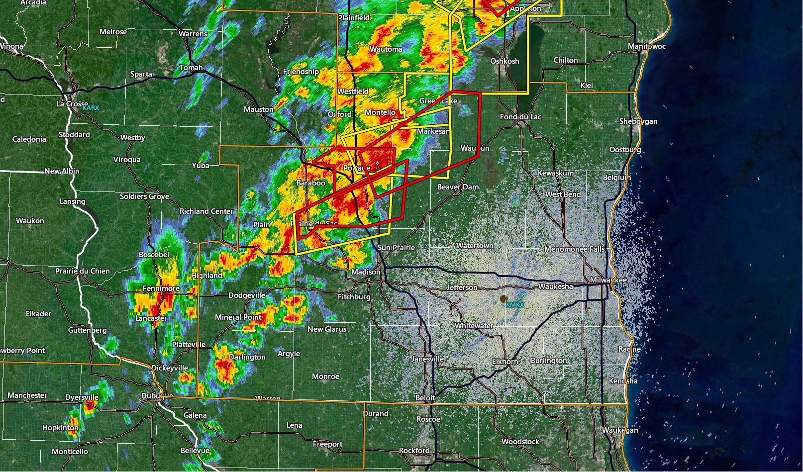 06/15/2022 - Radar and Warnings |
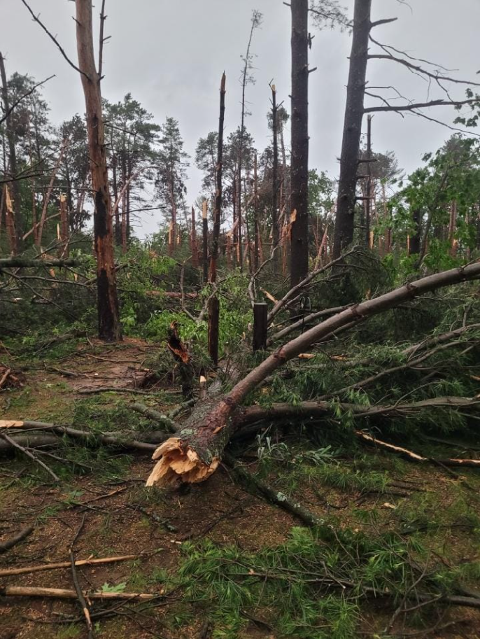
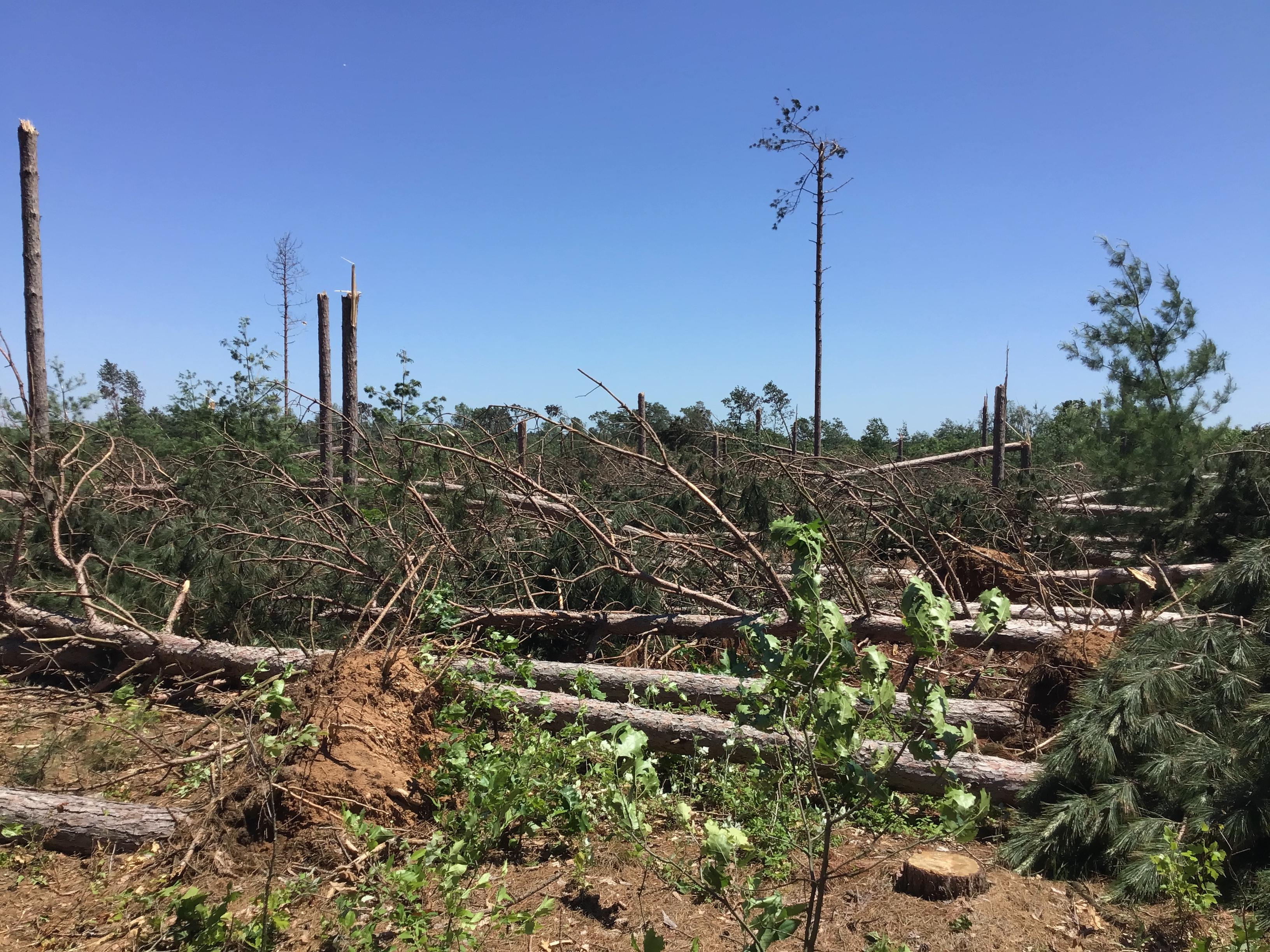
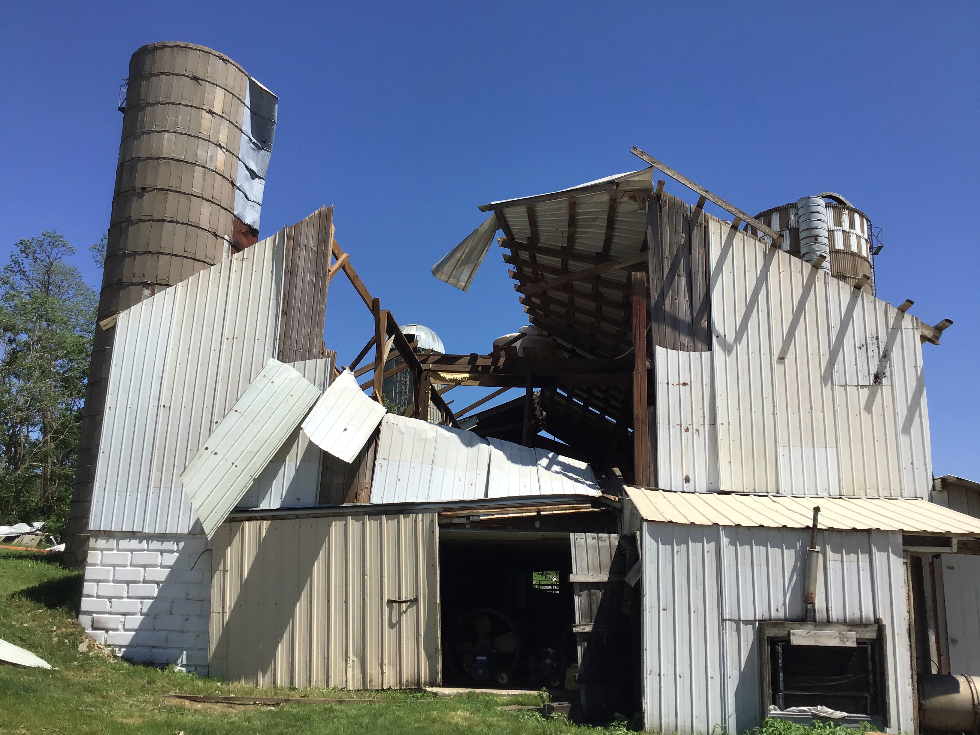
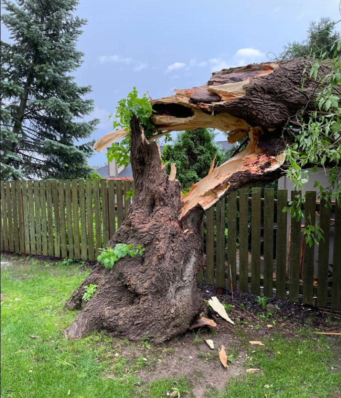
Marquette County Wind Damage:
 |
 |
 |
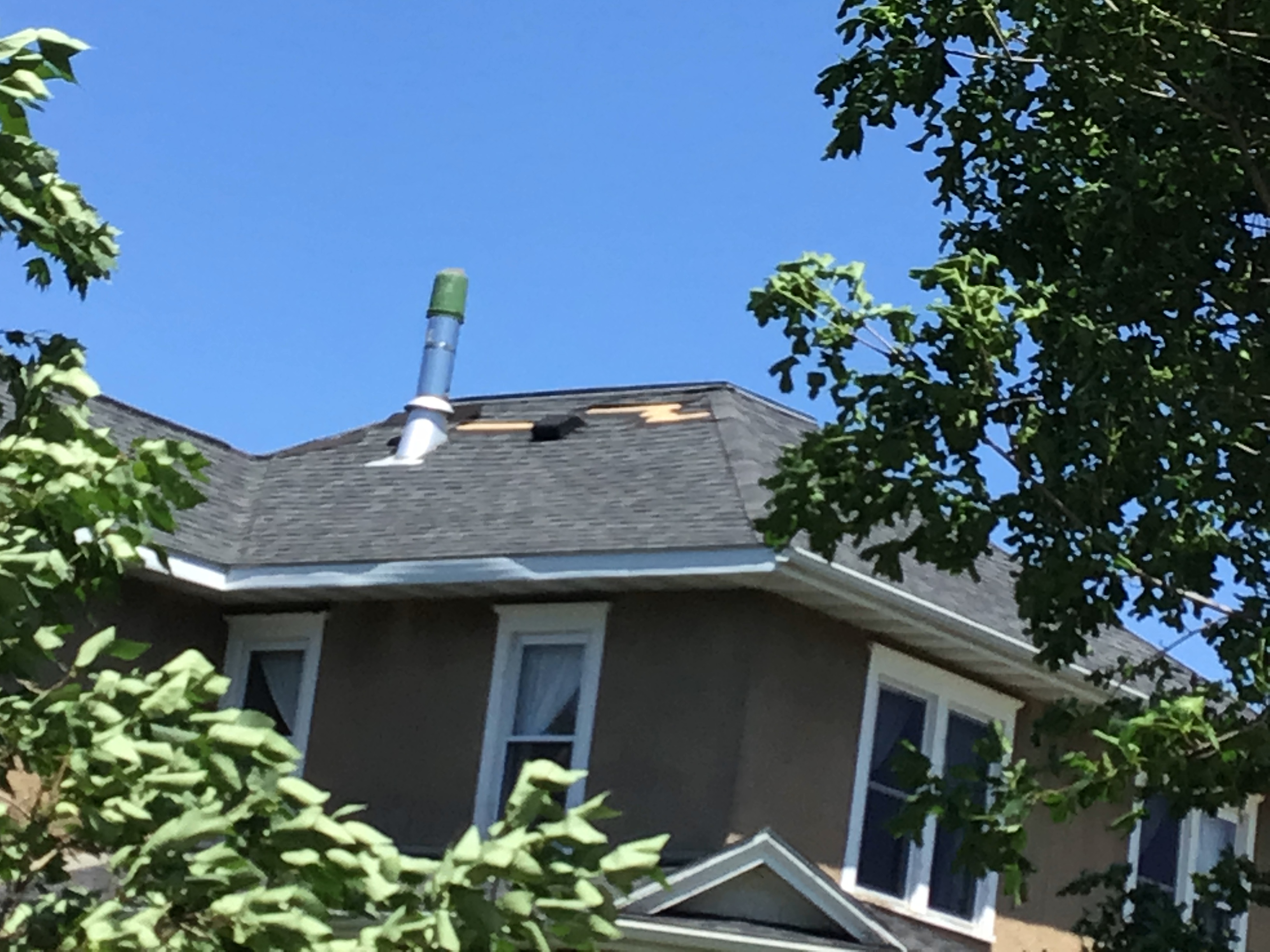 |
| Westfield damage from Becky Bryant Fabian | NWS Damage Survey | NWS Damage Survey | NWS Damage Survey |
Columbia and Dodge County Wind Damage and Flooding:
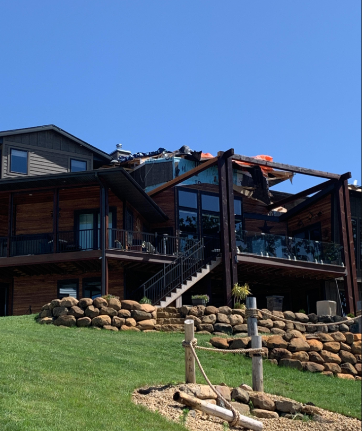 |
 |
 |
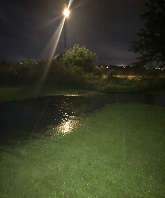 |
| Portage roof/porch damage from NWS storm survey | Fox Lake Shed Damage from Kari Behling | Lake Wisconsin area from @LoFrom Wisco | Ponding in Watertown yard from Craig Tarr |
Sheboygan and Milwaukee County Wind Damage:
 |
 |
 |
 |
| Sheboygan damage from Hanah Hillyard | Sheboygan from Hanah Hillyard | courtesy of Brian NiznanskyTMJ4 | Oak Creek (Milwaukee County) from Thomas C Mlot |
Rainfall
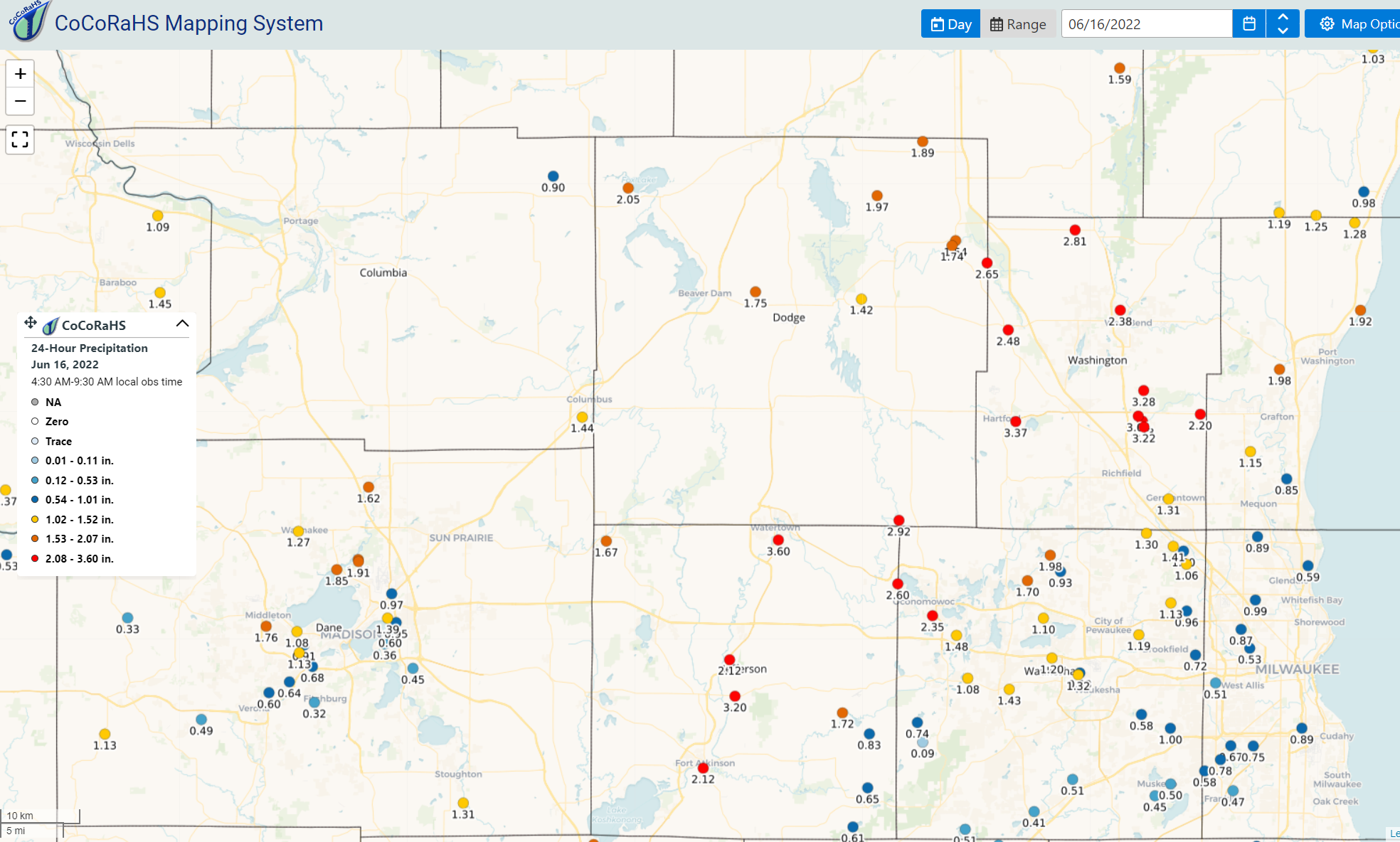 Public Information Statement
National Weather Service Milwaukee/Sullivan WI
1030 AM CDT Thu Jun 16 2022
...PRECIPITATION REPORTS...
Location Amount Time/Date Provider
...Wisconsin...
...Columbia County...
Univ Farm 1.99 in 0800 AM 06/16 COOP
Portage 1.53 in 1010 AM 06/16 AWS
Columbus 1.2 S 1.44 in 0700 AM 06/16 COCORAHS
Portage 1.40 in 1002 AM 06/16 CWOP
Cambria 6.9 NNW 1.20 in 0700 AM 06/16 COCORAHS
Lodi 1.10 in 0700 AM 06/16 COOP
Friesland 0.90 in 0640 AM 06/16 COCORAHS
...Dane County...
2.0 S Mount Horeb 2.05 in 0700 AM 06/16 COOP
DeForest 2.03 in 1010 AM 06/16 CWOP
Verona 5.5 WNW 1.93 in 0700 AM 06/16 COCORAHS
Madison 5.4 N 1.91 in 0700 AM 06/16 COCORAHS
Madison 4.8 NNW 1.85 in 0700 AM 06/16 COCORAHS
Deerfield 1.77 in 1008 AM 06/16 CWOP
4 SE Cross Plains 1.76 in 1002 AM 06/16 CWOP
Madison 6.4 W 1.76 in 0700 AM 06/16 COCORAHS
De Forest 1.4 SSW 1.76 in 0700 AM 06/16 COCORAHS
Deforest 1.70 in 1005 AM 06/16 CWOP
Morrisonville 0.1 ENE 1.65 in 0915 AM 06/16 COCORAHS
Madison 5.5 N 1.64 in 0800 AM 06/16 COCORAHS
De Forest 0.7 SW 1.62 in 0700 AM 06/16 COCORAHS
Sun Prairie 3.3 N 1.61 in 0800 AM 06/16 COCORAHS
Middleton 0.8 SSW 1.40 in 0800 AM 06/16 COCORAHS
Madison 3.2 ENE 1.39 in 0700 AM 06/16 COCORAHS
Sun Prairie 1.32 in 1005 AM 06/16 CWOP
Stoughton 2.7 SSE 1.31 in 0600 AM 06/16 COCORAHS
Madison-Dane County Airport 1.27 in 0953 AM 06/16 ASOS
Waunakee 0.7 WNW 1.27 in 0700 AM 06/16 COCORAHS
Stoughton 1.22 in 0630 AM 06/16 COOP
Mount Horeb 3.6 SSW 1.13 in 0700 AM 06/16 COCORAHS
Madison 4.3 WSW 1.13 in 0600 AM 06/16 COCORAHS
Middleton 1.10 in 1015 AM 06/16 AWOS
MIDDLETON 1.09 in 1005 AM 06/16 CWOP
Madison 4.0 W 1.08 in 0700 AM 06/16 COCORAHS
Madison 4.0 W 1.00 in 0731 AM 06/16 COCORAHS
Waunakee 2.6 W 1.00 in 0800 AM 06/16 COCORAHS
Sun Prairie 0.97 in 0950 AM 06/16 CWOP
Madison 4.4 NE 0.97 in 0800 AM 06/16 COCORAHS
Madison 3.7 E 0.95 in 0700 AM 06/16 COCORAHS
Madison 1.8 WSW 0.91 in 0900 AM 06/16 COCORAHS
Madison 3.7 WSW 0.91 in 0700 AM 06/16 COCORAHS
Cross Plains 0.5 SSW 0.88 in 0700 AM 06/16 COCORAHS
2.0 SW Shorewood Hills 0.87 in 0708 AM 06/16 COOP
Madison 7.0 WSW 0.87 in 0800 AM 06/16 COCORAHS
Madison South-UW Arboretum 0.73 in 0800 AM 06/16 COOP
Madison 4.0 SW 0.68 in 0700 AM 06/16 COCORAHS
3 WNW Fitchburg 0.64 in 0700 AM 06/16 COCORAHS
1 NE Verona 0.60 in 0700 AM 06/16 COCORAHS
Madison 3.2 E 0.60 in 0700 AM 06/16 COCORAHS
Monona 0.52 in 1005 AM 06/16 CWOP
...Dodge County...
Randolph 1.2 SE 4.70 in 0800 AM 06/16 COCORAHS
Watertown 1.2 NNE 3.88 in 0700 AM 06/16 COCORAHS
Ixonia 5.0 NE 2.92 in 0800 AM 06/16 COCORAHS
Theresa 3.1 SE 2.65 in 0714 AM 06/16 COCORAHS
Clyman 2.50 in 0700 AM 06/16 COOP
Fox Lake 2.3 WNW 2.05 in 0700 AM 06/16 COCORAHS
Horicon 2.02 in 0930 AM 06/16 RAWS
Mayville 4.9 NNW 1.97 in 0515 AM 06/16 COCORAHS
Beaver Dam 1.4 SSW 1.95 in 0800 AM 06/16 COCORAHS
Brownsville 1.89 in 0700 AM 06/16 COCORAHS
Beaver Dam 1.78 in 1010 AM 06/16 CWOP
Beaver Dam 3.9 E 1.75 in 0700 AM 06/16 COCORAHS
Theresa 0.5 SSW 1.74 in 0700 AM 06/16 COCORAHS
Columbus 4.8 ENE 1.72 in 0900 AM 06/16 COCORAHS
Horicon-WWTP 1.62 in 0700 AM 06/16 COOP
Theresa 0.1 ESE 1.54 in 0700 AM 06/16 COCORAHS
Horicon 2.1 ENE 1.42 in 0608 AM 06/16 COCORAHS
Juneau 1.09 in 1015 AM 06/16 AWOS
...Fond du Lac County...
Campbellsport 2.18 in 1005 AM 06/16 CWOP
Waupun 3.1 NNW 1.71 in 0700 AM 06/16 COCORAHS
Campbellsport 8.7 NNE 1.59 in 0600 AM 06/16 COCORAHS
Fond Du Lac Airport 1.03 in 0953 AM 06/16 ASOS
Fond Du Lac 1.7 E 1.00 in 0600 AM 06/16 COCORAHS
Ripon 2.1 S 0.97 in 0600 AM 06/16 COCORAHS
Mount Calvary 1.6 WSW 0.95 in 0700 AM 06/16 COCORAHS
Fond Du Lac 1 SW 0.91 in 0700 AM 06/16 UCOOP
1.8 E South Byron 0.91 in 1200 AM 06/16 COOP
1 ESE Fond Du Lac 0.79 in 1010 AM 06/16 AWS
St. Peter 0.66 in 0650 AM 06/16 UCOOP
Eldorado 2.3 S 0.59 in 0512 AM 06/16 COCORAHS
...Green County...
Juda 1.3 WNW 1.31 in 0700 AM 06/16 COCORAHS
Monticello 2.2 SE 1.22 in 0800 AM 06/16 COCORAHS
Winslow 0.98 in 1010 AM 06/16 CWOP
Monroe 5.1 NE 0.56 in 0800 AM 06/16 COCORAHS
1.2 W Monroe 0.52 in 0630 AM 06/16 COOP
...Green Lake County...
Princeton 3.4 SE 0.98 in 0700 AM 06/16 COCORAHS
Markesan 4.1 NNW 0.84 in 0800 AM 06/16 COCORAHS
Berlin 0.62 in 1010 AM 06/16 AWS
Green Lake 0.8 E 0.58 in 0700 AM 06/16 COCORAHS
...Iowa County...
Arena 0.1 WNW 0.53 in 0800 AM 06/16 COCORAHS
...Jefferson County...
Lake Mills 4.3 N 3.64 in 0700 AM 06/16 COCORAHS
Watertown 0.8 S 3.60 in 0700 AM 06/16 COCORAHS
Jefferson-WWTP 3.45 in 0700 AM 06/16 COOP
Jefferson 0.9 E 3.20 in 0606 AM 06/16 COCORAHS
Johnson Creek 3.2 NW 2.80 in 0700 AM 06/16 COCORAHS
Lac LaBelle 1.2 SW 2.60 in 0554 AM 06/16 COCORAHS
Fort Atkinson 0.3 SSE 2.12 in 0700 AM 06/16 COCORAHS
Johnson Creek 2.7 SSW 2.12 in 0500 AM 06/16 COCORAHS
Sullivan 2.6 SW 1.72 in 0700 AM 06/16 COCORAHS
Waterloo 1.67 in 0719 AM 06/16 COOP
Waterloo 1.67 in 0705 AM 06/16 COCORAHS
Waterloo 1.33 in 1009 AM 06/16 AWS
Sullivan 3.5 S 0.83 in 0700 AM 06/16 COCORAHS
Palmyra 1.5 N 0.65 in 0724 AM 06/16 COCORAHS
Palmyra 1.9 SW 0.61 in 0600 AM 06/16 COCORAHS
...Kenosha County...
Kenosha 3.1 SSE 1.69 in 0700 AM 06/16 COCORAHS
Pleasant Prairie 1.4 ESE 1.60 in 0700 AM 06/16 COCORAHS
Kenosha 3.8 WSW 1.54 in 0600 AM 06/16 COCORAHS
Pleasant Prairie 3.3 NW 1.45 in 0800 AM 06/16 COCORAHS
Pleasant Prairie 1.36 in 1000 AM 06/16 CWOP
Pleasant Prairie 2.1 E 1.21 in 0521 AM 06/16 COCORAHS
Kenosha 1.7 S 1.10 in 0630 AM 06/16 COCORAHS
2 NNW Kenosha 0.98 in 1009 AM 06/16 AWS
Kenosha 3.4 N 0.87 in 0800 AM 06/16 COCORAHS
Twin Lakes 1.5 NE 0.82 in 0700 AM 06/16 COCORAHS
2 SW Bohners Lake 0.67 in 0700 AM 06/16 COCORAHS
...Lafayette County...
South Wayne 3.9 SSW 0.64 in 0600 AM 06/16 COCORAHS
...Marquette County...
Westfield 6.3 NNW 1.79 in 0700 AM 06/16 COCORAHS
Westfield 0.5 N 1.55 in 0700 AM 06/16 COCORAHS
2.0 SE Montello 0.78 in 0700 AM 06/16 COOP
Neshkoro 5.0 SSE 0.74 in 0600 AM 06/16 COCORAHS
...Milwaukee County...
Oak Creek 1.42 in 1005 AM 06/16 CWOP
Cudahy 0.8 SE 1.20 in 0800 AM 06/16 COCORAHS
Milwaukee 3.6 NNW 0.99 in 0500 AM 06/16 COCORAHS
Greendale 0.92 in 1008 AM 06/16 CWOP
South Milwaukee-WWTP 0.92 in 0700 AM 06/16 COOP
Brown Deer 0.8 NW 0.89 in 0700 AM 06/16 COCORAHS
Milwaukee 7.1 SSE 0.89 in 0610 AM 06/16 COCORAHS
Milwaukee 2.4 WNW 0.87 in 0700 AM 06/16 COCORAHS
Brown Deer 0.85 in 1003 AM 06/16 CWOP
Greendale 1.0 ENE 0.85 in 0700 AM 06/16 COCORAHS
1 NNW Whitefish Bay 0.84 in 1010 AM 06/16 AWS
Milwaukee 0.81 in 1000 AM 06/16 CWOP
Hales Corners 0.7 SE 0.78 in 0700 AM 06/16 COCORAHS
Greendale 1.0 NNE 0.75 in 0500 AM 06/16 COCORAHS
Cudahy 0.72 in 1000 AM 06/16 CWOP
Milwaukee-Gen Mitchell Arpt 0.71 in 0952 AM 06/16 ASOS
1.8 SE Hales Corners 0.69 in 0630 AM 06/16 UCOOP
Greendale 1.5 NW 0.67 in 0700 AM 06/16 COCORAHS
River Hills 0.62 in 1009 AM 06/16 AWS
Fox Point 0.5 SSW 0.59 in 0700 AM 06/16 COCORAHS
Franklin 3.7 NW 0.58 in 0700 AM 06/16 COCORAHS
Brown Deer 0.57 in 1010 AM 06/16 AWS
Milwaukee 5.4 SSE 0.55 in 0743 AM 06/16 COCORAHS
Wauwatosa 1.9 E 0.53 in 0700 AM 06/16 COCORAHS
Milwaukee 0.52 in 1000 AM 06/16 CWOP
West Allis 1.3 NW 0.51 in 0800 AM 06/16 COCORAHS
...Ozaukee County...
Port Washington 1.98 in 1008 AM 06/16 AWS
Saukville 0.9 SSW 1.98 in 0700 AM 06/16 COCORAHS
Port Washington-CoCoRaHS 1.94 in 0700 AM 06/16 COCORAHS
Port Washington 4.2 NE 1.92 in 0700 AM 06/16 COCORAHS
Saukville 1.87 in 0630 AM 06/16 COOP
Belgium 1 NW 1.65 in 0730 AM 06/16 COOP
Cedarburg 1.61 in 1007 AM 06/16 CWOP
Grafton 1 S 1.56 in 0700 AM 06/16 COOP
Cedarburg 1.47 in 1010 AM 06/16 AWS
Cedar Grove 2.1 SSW 1.28 in 0740 AM 06/16 COCORAHS
Cedarburg 1.2 SSW 1.15 in 0700 AM 06/16 COCORAHS
Mequon 1.03 in 1005 AM 06/16 CWOP
Mequon 2.7 ENE 0.85 in 0700 AM 06/16 COCORAHS
Mequon 0.77 in 1005 AM 06/16 CWOP
...Racine County...
Waterford 1.15 in 0945 AM 06/16 HADS
Waterford 3.3 E 1.00 in 0700 AM 06/16 COCORAHS
Burlington 3.6 ENE 1.00 in 0517 AM 06/16 COCORAHS
7 N Union Grove 1.00 in 0655 AM 06/16 COCORAHS
Caledonia 3.6 WNW 0.87 in 0700 AM 06/16 COCORAHS
Rochester 1 S 0.85 in 0500 AM 06/16 COOP
Rochester 0.2 SE 0.73 in 0700 AM 06/16 COCORAHS
Elmwood Park 1.7 SSE 0.72 in 0700 AM 06/16 COCORAHS
Racine-Sewage Plant 0.70 in 0600 AM 06/16 COOP
Union Grove 0.63 in 0800 AM 06/16 COOP
Wind Lake 0.6 NE 0.59 in 0700 AM 06/16 COCORAHS
Yorkville 0.56 in 1000 AM 06/16 CWOP
Wind Lake 0.4 W 0.56 in 0700 AM 06/16 COCORAHS
Racine 2.4 S 0.54 in 0700 AM 06/16 COCORAHS
...Rock County...
3 E Edgerton 2.00 in 0700 AM 06/16 COCORAHS
Edgerton 1.55 in 1001 AM 06/16 CWOP
Janesville 7.0 NW 1.03 in 0700 AM 06/16 COCORAHS
...Sauk County...
Baraboo 3.2 ESE 1.45 in 0500 AM 06/16 COCORAHS
Sauk City 9.8 WSW 1.37 in 0726 AM 06/16 COCORAHS
Lone Rock-Airport 1.30 in 0956 AM 06/16 ASOS
1.3 N Prairie Du Sac 1.27 in 0600 AM 06/16 UCOOP
Baraboo 1.14 in 1000 AM 06/16 CWOP
Baraboo 6.0 NNE 1.09 in 0700 AM 06/16 COCORAHS
Wonewoc 2.0 SSW 1.07 in 0700 AM 06/16 COCORAHS
4 SSE Lime Ridge 0.99 in 0645 AM 06/16 COCORAHS
Prairie Du Sac 0.6 SSE 0.86 in 0637 AM 06/16 COCORAHS
Dells Baraboo 0.73 in 1015 AM 06/16 AWOS
Reedsburg 1.3 N 0.70 in 0420 AM 06/16 COCORAHS
Reedsburg-Airport 0.53 in 1015 AM 06/16 AWOS
...Sheboygan County...
Plymouth 1.81 in 1000 AM 06/16 CWOP
Howards Grove 1.49 in 1005 AM 06/16 CWOP
Howards Grove 1.49 in 1000 AM 06/16 CWOP
Plymouth 5.4 NE 1.45 in 0654 AM 06/16 COCORAHS
Sheboygan 3.7 NW 1.45 in 0800 AM 06/16 COCORAHS
Sheboygan 3.2 NW 1.36 in 0700 AM 06/16 COCORAHS
Sheboygan 1.31 in 1007 AM 06/16 CWOP
Sheboygan-Airport 1.27 in 0953 AM 06/16 ASOS
Belgium 3.8 NW 1.25 in 0600 AM 06/16 COCORAHS
Random Lake-CoCoRaHS 1.19 in 0700 AM 06/16 COCORAHS
Random Lake 1.16 in 1010 AM 06/16 CWOP
Howards Grove 1.14 in 1010 AM 06/16 AWS
Sheboygan 1.7 NNE 1.13 in 0700 AM 06/16 COCORAHS
Sheboygan 1.8 NE 1.09 in 0700 AM 06/16 COCORAHS
Sheboygan Falls 0.9 ENE 1.03 in 0700 AM 06/16 COCORAHS
Cedar Grove 0.4 NNE 0.98 in 0600 AM 06/16 COCORAHS
Sheboygan 3 S 0.91 in 0700 AM 06/16 COOP
Millhome 1 ESE 0.78 in 1009 AM 06/16 AWS
Sheboygan 3.3 SSW 0.71 in 0730 AM 06/16 COCORAHS
...Walworth County...
Pell Lake 1.23 in 1005 AM 06/16 CWOP
Genoa City 2.7 NW 1.10 in 0659 AM 06/16 COCORAHS
Burlington 3.1 NNW 1.07 in 0700 AM 06/16 COCORAHS
Genoa City 0.94 in 1004 AM 06/16 CWOP
Fontana 0.3 SSE 0.90 in 0700 AM 06/16 COCORAHS
Genoa City 0.85 in 1005 AM 06/16 AWS
Lake Geneva 0.6 ENE 0.84 in 0658 AM 06/16 COCORAHS
1 SSE Lake Geneva 0.82 in 1010 AM 06/16 AWS
...Washington County...
Hartford 1.7 ESE 3.37 in 0619 AM 06/16 COCORAHS
Jackson 1.9 N 3.28 in 0506 AM 06/16 COCORAHS
Slinger 1 WNW 3.24 in 0600 AM 06/16 COOP
Jackson 0.9 SSE 3.22 in 0600 AM 06/16 COCORAHS
Jackson 3.04 in 1000 AM 06/16 CWOP
Jackson 1 SW 3.04 in 0600 AM 06/16 COOP
Jackson-CoCoRaHS 3.04 in 0600 AM 06/16 COCORAHS
0.7 SW Hartford 3.00 in 0700 AM 06/16 COOP
Hartford 2.9 ENE 2.89 in 0700 AM 06/16 COCORAHS
Kewaskum 1.8 WNW 2.81 in 0700 AM 06/16 COCORAHS
Jackson 0.5 SSE 2.73 in 0700 AM 06/16 COCORAHS
West Bend 1.4 W 2.71 in 0800 AM 06/16 COCORAHS
Allenton 1.4 WSW 2.48 in 0529 AM 06/16 COCORAHS
West Bend 2.48 in 0900 AM 06/16 COOP
West Bend 5.4 SE 2.39 in 0800 AM 06/16 COCORAHS
West Bend 1.3 NNW 2.38 in 0554 AM 06/16 COCORAHS
West Bend 2.35 in 1009 AM 06/16 CWOP
Allenton 2.21 in 1000 AM 06/16 CWOP
Cedarburg 4.6 WNW 2.20 in 0800 AM 06/16 COCORAHS
Newburg 2.19 in 1010 AM 06/16 AWS
Colgate 2.14 in 1000 AM 06/16 CWOP
West Bend 1.84 in 1009 AM 06/16 CWOP
West Bend 1.80 in 1000 AM 06/16 CWOP
Jackson 3.2 SE 1.68 in 0500 AM 06/16 COCORAHS
West Bend 1.65 in 1010 AM 06/16 AWS
Hubertus 3.1 E 1.45 in 0600 AM 06/16 COCORAHS
Cudahy 1.43 in 1005 AM 06/16 CWOP
Germantown 0.6 S 1.31 in 0700 AM 06/16 COCORAHS
1.4 S Germantown 1.27 in 0700 AM 06/16 COOP
Colgate 1.20 in 0915 AM 06/16 CWOP
Jackson 1.10 in 1010 AM 06/16 CWOP
...Waukesha County...
Oconomowoc 2.55 in 0700 AM 06/16 COOP
Oconomowoc 4.6 NE 2.48 in 0900 AM 06/16 COCORAHS
Oconomowoc 2.35 in 0802 AM 06/16 UCOOP
Oconomowoc 0.9 W 2.35 in 0759 AM 06/16 COCORAHS
Hartland 5.0 NNE 1.98 in 0642 AM 06/16 COCORAHS
2 NNE Chenequa 1.88 in 1010 AM 06/16 AWS
Hartland 2.5 N 1.70 in 0700 AM 06/16 COCORAHS
Oconomowoc Lake 1.8 S 1.48 in 0720 AM 06/16 COCORAHS
Wales 0.7 NE 1.43 in 0600 AM 06/16 COCORAHS
Menomonee Falls 1.9 NNE 1.41 in 0618 AM 06/16 COCORAHS
Wales 0.4 NW 1.34 in 0800 AM 06/16 COCORAHS
Waukesha 1.6 NW 1.32 in 0700 AM 06/16 COCORAHS
Menomonee Falls 3.2 NNW 1.30 in 0700 AM 06/16 COCORAHS
Waukesha 4.0 NW 1.20 in 0700 AM 06/16 COCORAHS
Brookfield 2.5 WNW 1.19 in 0700 AM 06/16 COCORAHS
Menomonee Falls 2.6 S 1.13 in 0700 AM 06/16 COCORAHS
1 SSE Lannon 1.10 in 1005 AM 06/16 AWS
Pewaukee 3.2 W 1.10 in 0700 AM 06/16 COCORAHS
Oconomowoc 6.3 SSE 1.08 in 0700 AM 06/16 COCORAHS
Menomonee Falls 1.7 ENE 1.06 in 0745 AM 06/16 COCORAHS
Delafield 1.05 in 1010 AM 06/16 CWOP
New Berlin 0.6 ESE 1.00 in 0700 AM 06/16 COCORAHS
Menomonee Falls 2.0 NE 1.00 in 0700 AM 06/16 COCORAHS
1 WSW Butler 0.96 in 0601 AM 06/16 COCORAHS
2.9 W Brookfield 0.94 in 0725 AM 06/16 COOP
Waukesha 1.6 NW 0.93 in 0800 AM 06/16 COCORAHS
1 E Merton 0.93 in 0630 AM 06/16 COCORAHS
Butler 0.91 in 1010 AM 06/16 AWS
Genesee Depot 0.85 in 1010 AM 06/16 CWOP
Brookfield 0.84 in 1000 AM 06/16 CWOP
Pewaukee 0.83 in 1005 AM 06/16 CWOP
Waukesha 3.0 W 0.76 in 0700 AM 06/16 COCORAHS
Dousman 3.4 SW 0.74 in 0700 AM 06/16 COCORAHS
Waukesha 0.73 in 1005 AM 06/16 CWOP
Elm Grove 0.4 NE 0.72 in 0600 AM 06/16 COCORAHS
Waukesha 1.7 ESE 0.70 in 0850 AM 06/16 COCORAHS
Brookfield 0.67 in 1008 AM 06/16 CWOP
Brookfield 0.63 in 1005 AM 06/16 CWOP
New Berlin 1.9 WNW 0.58 in 0700 AM 06/16 COCORAHS
Mukwonago 5.3 W 0.51 in 0700 AM 06/16 COCORAHS
Waukesha 7.2 SSW 0.51 in 0800 AM 06/16 COCORAHS
Muskego 1.0 NNE 0.50 in 0800 AM 06/16 COCORAHS
...Maritime Stations...
Racine 0.57 in 0800 AM 06/16 COOP
Observations are collected from a variety of sources with varying
equipment and exposures. We thank all volunteer weather observers
for their dedication. Not all data listed are considered official.
$$
Public Information Statement
National Weather Service Milwaukee/Sullivan WI
1030 AM CDT Thu Jun 16 2022
...PRECIPITATION REPORTS...
Location Amount Time/Date Provider
...Wisconsin...
...Columbia County...
Univ Farm 1.99 in 0800 AM 06/16 COOP
Portage 1.53 in 1010 AM 06/16 AWS
Columbus 1.2 S 1.44 in 0700 AM 06/16 COCORAHS
Portage 1.40 in 1002 AM 06/16 CWOP
Cambria 6.9 NNW 1.20 in 0700 AM 06/16 COCORAHS
Lodi 1.10 in 0700 AM 06/16 COOP
Friesland 0.90 in 0640 AM 06/16 COCORAHS
...Dane County...
2.0 S Mount Horeb 2.05 in 0700 AM 06/16 COOP
DeForest 2.03 in 1010 AM 06/16 CWOP
Verona 5.5 WNW 1.93 in 0700 AM 06/16 COCORAHS
Madison 5.4 N 1.91 in 0700 AM 06/16 COCORAHS
Madison 4.8 NNW 1.85 in 0700 AM 06/16 COCORAHS
Deerfield 1.77 in 1008 AM 06/16 CWOP
4 SE Cross Plains 1.76 in 1002 AM 06/16 CWOP
Madison 6.4 W 1.76 in 0700 AM 06/16 COCORAHS
De Forest 1.4 SSW 1.76 in 0700 AM 06/16 COCORAHS
Deforest 1.70 in 1005 AM 06/16 CWOP
Morrisonville 0.1 ENE 1.65 in 0915 AM 06/16 COCORAHS
Madison 5.5 N 1.64 in 0800 AM 06/16 COCORAHS
De Forest 0.7 SW 1.62 in 0700 AM 06/16 COCORAHS
Sun Prairie 3.3 N 1.61 in 0800 AM 06/16 COCORAHS
Middleton 0.8 SSW 1.40 in 0800 AM 06/16 COCORAHS
Madison 3.2 ENE 1.39 in 0700 AM 06/16 COCORAHS
Sun Prairie 1.32 in 1005 AM 06/16 CWOP
Stoughton 2.7 SSE 1.31 in 0600 AM 06/16 COCORAHS
Madison-Dane County Airport 1.27 in 0953 AM 06/16 ASOS
Waunakee 0.7 WNW 1.27 in 0700 AM 06/16 COCORAHS
Stoughton 1.22 in 0630 AM 06/16 COOP
Mount Horeb 3.6 SSW 1.13 in 0700 AM 06/16 COCORAHS
Madison 4.3 WSW 1.13 in 0600 AM 06/16 COCORAHS
Middleton 1.10 in 1015 AM 06/16 AWOS
MIDDLETON 1.09 in 1005 AM 06/16 CWOP
Madison 4.0 W 1.08 in 0700 AM 06/16 COCORAHS
Madison 4.0 W 1.00 in 0731 AM 06/16 COCORAHS
Waunakee 2.6 W 1.00 in 0800 AM 06/16 COCORAHS
Sun Prairie 0.97 in 0950 AM 06/16 CWOP
Madison 4.4 NE 0.97 in 0800 AM 06/16 COCORAHS
Madison 3.7 E 0.95 in 0700 AM 06/16 COCORAHS
Madison 1.8 WSW 0.91 in 0900 AM 06/16 COCORAHS
Madison 3.7 WSW 0.91 in 0700 AM 06/16 COCORAHS
Cross Plains 0.5 SSW 0.88 in 0700 AM 06/16 COCORAHS
2.0 SW Shorewood Hills 0.87 in 0708 AM 06/16 COOP
Madison 7.0 WSW 0.87 in 0800 AM 06/16 COCORAHS
Madison South-UW Arboretum 0.73 in 0800 AM 06/16 COOP
Madison 4.0 SW 0.68 in 0700 AM 06/16 COCORAHS
3 WNW Fitchburg 0.64 in 0700 AM 06/16 COCORAHS
1 NE Verona 0.60 in 0700 AM 06/16 COCORAHS
Madison 3.2 E 0.60 in 0700 AM 06/16 COCORAHS
Monona 0.52 in 1005 AM 06/16 CWOP
...Dodge County...
Randolph 1.2 SE 4.70 in 0800 AM 06/16 COCORAHS
Watertown 1.2 NNE 3.88 in 0700 AM 06/16 COCORAHS
Ixonia 5.0 NE 2.92 in 0800 AM 06/16 COCORAHS
Theresa 3.1 SE 2.65 in 0714 AM 06/16 COCORAHS
Clyman 2.50 in 0700 AM 06/16 COOP
Fox Lake 2.3 WNW 2.05 in 0700 AM 06/16 COCORAHS
Horicon 2.02 in 0930 AM 06/16 RAWS
Mayville 4.9 NNW 1.97 in 0515 AM 06/16 COCORAHS
Beaver Dam 1.4 SSW 1.95 in 0800 AM 06/16 COCORAHS
Brownsville 1.89 in 0700 AM 06/16 COCORAHS
Beaver Dam 1.78 in 1010 AM 06/16 CWOP
Beaver Dam 3.9 E 1.75 in 0700 AM 06/16 COCORAHS
Theresa 0.5 SSW 1.74 in 0700 AM 06/16 COCORAHS
Columbus 4.8 ENE 1.72 in 0900 AM 06/16 COCORAHS
Horicon-WWTP 1.62 in 0700 AM 06/16 COOP
Theresa 0.1 ESE 1.54 in 0700 AM 06/16 COCORAHS
Horicon 2.1 ENE 1.42 in 0608 AM 06/16 COCORAHS
Juneau 1.09 in 1015 AM 06/16 AWOS
...Fond du Lac County...
Campbellsport 2.18 in 1005 AM 06/16 CWOP
Waupun 3.1 NNW 1.71 in 0700 AM 06/16 COCORAHS
Campbellsport 8.7 NNE 1.59 in 0600 AM 06/16 COCORAHS
Fond Du Lac Airport 1.03 in 0953 AM 06/16 ASOS
Fond Du Lac 1.7 E 1.00 in 0600 AM 06/16 COCORAHS
Ripon 2.1 S 0.97 in 0600 AM 06/16 COCORAHS
Mount Calvary 1.6 WSW 0.95 in 0700 AM 06/16 COCORAHS
Fond Du Lac 1 SW 0.91 in 0700 AM 06/16 UCOOP
1.8 E South Byron 0.91 in 1200 AM 06/16 COOP
1 ESE Fond Du Lac 0.79 in 1010 AM 06/16 AWS
St. Peter 0.66 in 0650 AM 06/16 UCOOP
Eldorado 2.3 S 0.59 in 0512 AM 06/16 COCORAHS
...Green County...
Juda 1.3 WNW 1.31 in 0700 AM 06/16 COCORAHS
Monticello 2.2 SE 1.22 in 0800 AM 06/16 COCORAHS
Winslow 0.98 in 1010 AM 06/16 CWOP
Monroe 5.1 NE 0.56 in 0800 AM 06/16 COCORAHS
1.2 W Monroe 0.52 in 0630 AM 06/16 COOP
...Green Lake County...
Princeton 3.4 SE 0.98 in 0700 AM 06/16 COCORAHS
Markesan 4.1 NNW 0.84 in 0800 AM 06/16 COCORAHS
Berlin 0.62 in 1010 AM 06/16 AWS
Green Lake 0.8 E 0.58 in 0700 AM 06/16 COCORAHS
...Iowa County...
Arena 0.1 WNW 0.53 in 0800 AM 06/16 COCORAHS
...Jefferson County...
Lake Mills 4.3 N 3.64 in 0700 AM 06/16 COCORAHS
Watertown 0.8 S 3.60 in 0700 AM 06/16 COCORAHS
Jefferson-WWTP 3.45 in 0700 AM 06/16 COOP
Jefferson 0.9 E 3.20 in 0606 AM 06/16 COCORAHS
Johnson Creek 3.2 NW 2.80 in 0700 AM 06/16 COCORAHS
Lac LaBelle 1.2 SW 2.60 in 0554 AM 06/16 COCORAHS
Fort Atkinson 0.3 SSE 2.12 in 0700 AM 06/16 COCORAHS
Johnson Creek 2.7 SSW 2.12 in 0500 AM 06/16 COCORAHS
Sullivan 2.6 SW 1.72 in 0700 AM 06/16 COCORAHS
Waterloo 1.67 in 0719 AM 06/16 COOP
Waterloo 1.67 in 0705 AM 06/16 COCORAHS
Waterloo 1.33 in 1009 AM 06/16 AWS
Sullivan 3.5 S 0.83 in 0700 AM 06/16 COCORAHS
Palmyra 1.5 N 0.65 in 0724 AM 06/16 COCORAHS
Palmyra 1.9 SW 0.61 in 0600 AM 06/16 COCORAHS
...Kenosha County...
Kenosha 3.1 SSE 1.69 in 0700 AM 06/16 COCORAHS
Pleasant Prairie 1.4 ESE 1.60 in 0700 AM 06/16 COCORAHS
Kenosha 3.8 WSW 1.54 in 0600 AM 06/16 COCORAHS
Pleasant Prairie 3.3 NW 1.45 in 0800 AM 06/16 COCORAHS
Pleasant Prairie 1.36 in 1000 AM 06/16 CWOP
Pleasant Prairie 2.1 E 1.21 in 0521 AM 06/16 COCORAHS
Kenosha 1.7 S 1.10 in 0630 AM 06/16 COCORAHS
2 NNW Kenosha 0.98 in 1009 AM 06/16 AWS
Kenosha 3.4 N 0.87 in 0800 AM 06/16 COCORAHS
Twin Lakes 1.5 NE 0.82 in 0700 AM 06/16 COCORAHS
2 SW Bohners Lake 0.67 in 0700 AM 06/16 COCORAHS
...Lafayette County...
South Wayne 3.9 SSW 0.64 in 0600 AM 06/16 COCORAHS
...Marquette County...
Westfield 6.3 NNW 1.79 in 0700 AM 06/16 COCORAHS
Westfield 0.5 N 1.55 in 0700 AM 06/16 COCORAHS
2.0 SE Montello 0.78 in 0700 AM 06/16 COOP
Neshkoro 5.0 SSE 0.74 in 0600 AM 06/16 COCORAHS
...Milwaukee County...
Oak Creek 1.42 in 1005 AM 06/16 CWOP
Cudahy 0.8 SE 1.20 in 0800 AM 06/16 COCORAHS
Milwaukee 3.6 NNW 0.99 in 0500 AM 06/16 COCORAHS
Greendale 0.92 in 1008 AM 06/16 CWOP
South Milwaukee-WWTP 0.92 in 0700 AM 06/16 COOP
Brown Deer 0.8 NW 0.89 in 0700 AM 06/16 COCORAHS
Milwaukee 7.1 SSE 0.89 in 0610 AM 06/16 COCORAHS
Milwaukee 2.4 WNW 0.87 in 0700 AM 06/16 COCORAHS
Brown Deer 0.85 in 1003 AM 06/16 CWOP
Greendale 1.0 ENE 0.85 in 0700 AM 06/16 COCORAHS
1 NNW Whitefish Bay 0.84 in 1010 AM 06/16 AWS
Milwaukee 0.81 in 1000 AM 06/16 CWOP
Hales Corners 0.7 SE 0.78 in 0700 AM 06/16 COCORAHS
Greendale 1.0 NNE 0.75 in 0500 AM 06/16 COCORAHS
Cudahy 0.72 in 1000 AM 06/16 CWOP
Milwaukee-Gen Mitchell Arpt 0.71 in 0952 AM 06/16 ASOS
1.8 SE Hales Corners 0.69 in 0630 AM 06/16 UCOOP
Greendale 1.5 NW 0.67 in 0700 AM 06/16 COCORAHS
River Hills 0.62 in 1009 AM 06/16 AWS
Fox Point 0.5 SSW 0.59 in 0700 AM 06/16 COCORAHS
Franklin 3.7 NW 0.58 in 0700 AM 06/16 COCORAHS
Brown Deer 0.57 in 1010 AM 06/16 AWS
Milwaukee 5.4 SSE 0.55 in 0743 AM 06/16 COCORAHS
Wauwatosa 1.9 E 0.53 in 0700 AM 06/16 COCORAHS
Milwaukee 0.52 in 1000 AM 06/16 CWOP
West Allis 1.3 NW 0.51 in 0800 AM 06/16 COCORAHS
...Ozaukee County...
Port Washington 1.98 in 1008 AM 06/16 AWS
Saukville 0.9 SSW 1.98 in 0700 AM 06/16 COCORAHS
Port Washington-CoCoRaHS 1.94 in 0700 AM 06/16 COCORAHS
Port Washington 4.2 NE 1.92 in 0700 AM 06/16 COCORAHS
Saukville 1.87 in 0630 AM 06/16 COOP
Belgium 1 NW 1.65 in 0730 AM 06/16 COOP
Cedarburg 1.61 in 1007 AM 06/16 CWOP
Grafton 1 S 1.56 in 0700 AM 06/16 COOP
Cedarburg 1.47 in 1010 AM 06/16 AWS
Cedar Grove 2.1 SSW 1.28 in 0740 AM 06/16 COCORAHS
Cedarburg 1.2 SSW 1.15 in 0700 AM 06/16 COCORAHS
Mequon 1.03 in 1005 AM 06/16 CWOP
Mequon 2.7 ENE 0.85 in 0700 AM 06/16 COCORAHS
Mequon 0.77 in 1005 AM 06/16 CWOP
...Racine County...
Waterford 1.15 in 0945 AM 06/16 HADS
Waterford 3.3 E 1.00 in 0700 AM 06/16 COCORAHS
Burlington 3.6 ENE 1.00 in 0517 AM 06/16 COCORAHS
7 N Union Grove 1.00 in 0655 AM 06/16 COCORAHS
Caledonia 3.6 WNW 0.87 in 0700 AM 06/16 COCORAHS
Rochester 1 S 0.85 in 0500 AM 06/16 COOP
Rochester 0.2 SE 0.73 in 0700 AM 06/16 COCORAHS
Elmwood Park 1.7 SSE 0.72 in 0700 AM 06/16 COCORAHS
Racine-Sewage Plant 0.70 in 0600 AM 06/16 COOP
Union Grove 0.63 in 0800 AM 06/16 COOP
Wind Lake 0.6 NE 0.59 in 0700 AM 06/16 COCORAHS
Yorkville 0.56 in 1000 AM 06/16 CWOP
Wind Lake 0.4 W 0.56 in 0700 AM 06/16 COCORAHS
Racine 2.4 S 0.54 in 0700 AM 06/16 COCORAHS
...Rock County...
3 E Edgerton 2.00 in 0700 AM 06/16 COCORAHS
Edgerton 1.55 in 1001 AM 06/16 CWOP
Janesville 7.0 NW 1.03 in 0700 AM 06/16 COCORAHS
...Sauk County...
Baraboo 3.2 ESE 1.45 in 0500 AM 06/16 COCORAHS
Sauk City 9.8 WSW 1.37 in 0726 AM 06/16 COCORAHS
Lone Rock-Airport 1.30 in 0956 AM 06/16 ASOS
1.3 N Prairie Du Sac 1.27 in 0600 AM 06/16 UCOOP
Baraboo 1.14 in 1000 AM 06/16 CWOP
Baraboo 6.0 NNE 1.09 in 0700 AM 06/16 COCORAHS
Wonewoc 2.0 SSW 1.07 in 0700 AM 06/16 COCORAHS
4 SSE Lime Ridge 0.99 in 0645 AM 06/16 COCORAHS
Prairie Du Sac 0.6 SSE 0.86 in 0637 AM 06/16 COCORAHS
Dells Baraboo 0.73 in 1015 AM 06/16 AWOS
Reedsburg 1.3 N 0.70 in 0420 AM 06/16 COCORAHS
Reedsburg-Airport 0.53 in 1015 AM 06/16 AWOS
...Sheboygan County...
Plymouth 1.81 in 1000 AM 06/16 CWOP
Howards Grove 1.49 in 1005 AM 06/16 CWOP
Howards Grove 1.49 in 1000 AM 06/16 CWOP
Plymouth 5.4 NE 1.45 in 0654 AM 06/16 COCORAHS
Sheboygan 3.7 NW 1.45 in 0800 AM 06/16 COCORAHS
Sheboygan 3.2 NW 1.36 in 0700 AM 06/16 COCORAHS
Sheboygan 1.31 in 1007 AM 06/16 CWOP
Sheboygan-Airport 1.27 in 0953 AM 06/16 ASOS
Belgium 3.8 NW 1.25 in 0600 AM 06/16 COCORAHS
Random Lake-CoCoRaHS 1.19 in 0700 AM 06/16 COCORAHS
Random Lake 1.16 in 1010 AM 06/16 CWOP
Howards Grove 1.14 in 1010 AM 06/16 AWS
Sheboygan 1.7 NNE 1.13 in 0700 AM 06/16 COCORAHS
Sheboygan 1.8 NE 1.09 in 0700 AM 06/16 COCORAHS
Sheboygan Falls 0.9 ENE 1.03 in 0700 AM 06/16 COCORAHS
Cedar Grove 0.4 NNE 0.98 in 0600 AM 06/16 COCORAHS
Sheboygan 3 S 0.91 in 0700 AM 06/16 COOP
Millhome 1 ESE 0.78 in 1009 AM 06/16 AWS
Sheboygan 3.3 SSW 0.71 in 0730 AM 06/16 COCORAHS
...Walworth County...
Pell Lake 1.23 in 1005 AM 06/16 CWOP
Genoa City 2.7 NW 1.10 in 0659 AM 06/16 COCORAHS
Burlington 3.1 NNW 1.07 in 0700 AM 06/16 COCORAHS
Genoa City 0.94 in 1004 AM 06/16 CWOP
Fontana 0.3 SSE 0.90 in 0700 AM 06/16 COCORAHS
Genoa City 0.85 in 1005 AM 06/16 AWS
Lake Geneva 0.6 ENE 0.84 in 0658 AM 06/16 COCORAHS
1 SSE Lake Geneva 0.82 in 1010 AM 06/16 AWS
...Washington County...
Hartford 1.7 ESE 3.37 in 0619 AM 06/16 COCORAHS
Jackson 1.9 N 3.28 in 0506 AM 06/16 COCORAHS
Slinger 1 WNW 3.24 in 0600 AM 06/16 COOP
Jackson 0.9 SSE 3.22 in 0600 AM 06/16 COCORAHS
Jackson 3.04 in 1000 AM 06/16 CWOP
Jackson 1 SW 3.04 in 0600 AM 06/16 COOP
Jackson-CoCoRaHS 3.04 in 0600 AM 06/16 COCORAHS
0.7 SW Hartford 3.00 in 0700 AM 06/16 COOP
Hartford 2.9 ENE 2.89 in 0700 AM 06/16 COCORAHS
Kewaskum 1.8 WNW 2.81 in 0700 AM 06/16 COCORAHS
Jackson 0.5 SSE 2.73 in 0700 AM 06/16 COCORAHS
West Bend 1.4 W 2.71 in 0800 AM 06/16 COCORAHS
Allenton 1.4 WSW 2.48 in 0529 AM 06/16 COCORAHS
West Bend 2.48 in 0900 AM 06/16 COOP
West Bend 5.4 SE 2.39 in 0800 AM 06/16 COCORAHS
West Bend 1.3 NNW 2.38 in 0554 AM 06/16 COCORAHS
West Bend 2.35 in 1009 AM 06/16 CWOP
Allenton 2.21 in 1000 AM 06/16 CWOP
Cedarburg 4.6 WNW 2.20 in 0800 AM 06/16 COCORAHS
Newburg 2.19 in 1010 AM 06/16 AWS
Colgate 2.14 in 1000 AM 06/16 CWOP
West Bend 1.84 in 1009 AM 06/16 CWOP
West Bend 1.80 in 1000 AM 06/16 CWOP
Jackson 3.2 SE 1.68 in 0500 AM 06/16 COCORAHS
West Bend 1.65 in 1010 AM 06/16 AWS
Hubertus 3.1 E 1.45 in 0600 AM 06/16 COCORAHS
Cudahy 1.43 in 1005 AM 06/16 CWOP
Germantown 0.6 S 1.31 in 0700 AM 06/16 COCORAHS
1.4 S Germantown 1.27 in 0700 AM 06/16 COOP
Colgate 1.20 in 0915 AM 06/16 CWOP
Jackson 1.10 in 1010 AM 06/16 CWOP
...Waukesha County...
Oconomowoc 2.55 in 0700 AM 06/16 COOP
Oconomowoc 4.6 NE 2.48 in 0900 AM 06/16 COCORAHS
Oconomowoc 2.35 in 0802 AM 06/16 UCOOP
Oconomowoc 0.9 W 2.35 in 0759 AM 06/16 COCORAHS
Hartland 5.0 NNE 1.98 in 0642 AM 06/16 COCORAHS
2 NNE Chenequa 1.88 in 1010 AM 06/16 AWS
Hartland 2.5 N 1.70 in 0700 AM 06/16 COCORAHS
Oconomowoc Lake 1.8 S 1.48 in 0720 AM 06/16 COCORAHS
Wales 0.7 NE 1.43 in 0600 AM 06/16 COCORAHS
Menomonee Falls 1.9 NNE 1.41 in 0618 AM 06/16 COCORAHS
Wales 0.4 NW 1.34 in 0800 AM 06/16 COCORAHS
Waukesha 1.6 NW 1.32 in 0700 AM 06/16 COCORAHS
Menomonee Falls 3.2 NNW 1.30 in 0700 AM 06/16 COCORAHS
Waukesha 4.0 NW 1.20 in 0700 AM 06/16 COCORAHS
Brookfield 2.5 WNW 1.19 in 0700 AM 06/16 COCORAHS
Menomonee Falls 2.6 S 1.13 in 0700 AM 06/16 COCORAHS
1 SSE Lannon 1.10 in 1005 AM 06/16 AWS
Pewaukee 3.2 W 1.10 in 0700 AM 06/16 COCORAHS
Oconomowoc 6.3 SSE 1.08 in 0700 AM 06/16 COCORAHS
Menomonee Falls 1.7 ENE 1.06 in 0745 AM 06/16 COCORAHS
Delafield 1.05 in 1010 AM 06/16 CWOP
New Berlin 0.6 ESE 1.00 in 0700 AM 06/16 COCORAHS
Menomonee Falls 2.0 NE 1.00 in 0700 AM 06/16 COCORAHS
1 WSW Butler 0.96 in 0601 AM 06/16 COCORAHS
2.9 W Brookfield 0.94 in 0725 AM 06/16 COOP
Waukesha 1.6 NW 0.93 in 0800 AM 06/16 COCORAHS
1 E Merton 0.93 in 0630 AM 06/16 COCORAHS
Butler 0.91 in 1010 AM 06/16 AWS
Genesee Depot 0.85 in 1010 AM 06/16 CWOP
Brookfield 0.84 in 1000 AM 06/16 CWOP
Pewaukee 0.83 in 1005 AM 06/16 CWOP
Waukesha 3.0 W 0.76 in 0700 AM 06/16 COCORAHS
Dousman 3.4 SW 0.74 in 0700 AM 06/16 COCORAHS
Waukesha 0.73 in 1005 AM 06/16 CWOP
Elm Grove 0.4 NE 0.72 in 0600 AM 06/16 COCORAHS
Waukesha 1.7 ESE 0.70 in 0850 AM 06/16 COCORAHS
Brookfield 0.67 in 1008 AM 06/16 CWOP
Brookfield 0.63 in 1005 AM 06/16 CWOP
New Berlin 1.9 WNW 0.58 in 0700 AM 06/16 COCORAHS
Mukwonago 5.3 W 0.51 in 0700 AM 06/16 COCORAHS
Waukesha 7.2 SSW 0.51 in 0800 AM 06/16 COCORAHS
Muskego 1.0 NNE 0.50 in 0800 AM 06/16 COCORAHS
...Maritime Stations...
Racine 0.57 in 0800 AM 06/16 COOP
Observations are collected from a variety of sources with varying
equipment and exposures. We thank all volunteer weather observers
for their dedication. Not all data listed are considered official.
$$
Storm Reports
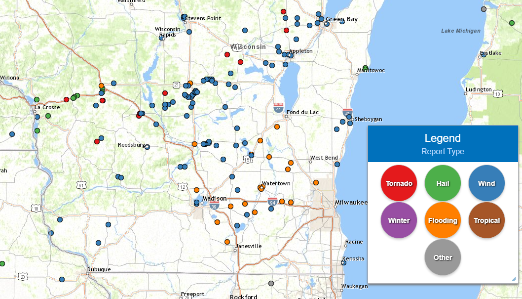
Local Storm Reports |
NWS Milwaukee Storm Survey Reports |
||
PRELIMINARY LOCAL STORM REPORT...SUMMARY
NATIONAL WEATHER SERVICE MILWAUKEE/SULLIVAN WI
337 PM CDT THU JUN 16 2022

..TIME...   ...EVENT...      ...CITY LOCATION...     ...LAT.LON...
..DATE...   ....MAG....      ..COUNTY LOCATION..ST.. ...SOURCE....
            ..REMARKS..

1100 PM     FLASH FLOOD      1 S NASHOTAH            43.08N 88.40W
06/15/2022                   WAUKESHA           WI   EMERGENCY MNGR

            GRAVEL WASHED OUT FROM ROADS: HWY C NORTH OF
            HWY 18 AND HWY 83 NORTH OF 16. TIME
            ESTIMATED FROM RADAR.

0815 PM     TSTM WND DMG     2 WNW SHEBOYGAN         43.77N 87.75W
06/15/2022                   SHEBOYGAN          WI   EMERGENCY MNGR

            MULTIPLE TREES DOWN AND POWERLINES SNAPPED.
            MOST EXTENSIVE DAMAGE IS FROM NORTH AND
            TAYLOR AVE TO THE LAKESHORE. TREE DAMAGE
            CONTINUES BACK TO THE SOUTHWEST TO WALDO.
            TIME ESTIMATED FROM RADAR.

0820 PM     TSTM WND DMG     2 SE KOHLER             43.72N 87.74W
06/15/2022                   SHEBOYGAN          WI   PUBLIC

            LARGE BRANCHES DOWN.

0820 PM     TSTM WND GST     SHEBOYGAN FALLS         43.73N 87.82W
06/15/2022  M51 MPH          SHEBOYGAN          WI   TRAINED SPOTTER


0505 PM     TSTM WND DMG     REEDSBURG               43.53N 90.00W
06/15/2022                   SAUK               WI   PUBLIC

            2 INCH LIMBS DOWN, TIME ESTIMATED ON RADAR.

0541 PM     TSTM WND DMG     MERRIMAC                43.37N 89.63W
06/15/2022                   SAUK               WI   LAW ENFORCEMENT

            TREE WENT THROUGH ROOF OF HOUSE. TIME
            ESTIMATED ON RADAR.

0934 PM     TSTM WND DMG     PORT WASHINGTON         43.39N 87.88W
06/15/2022                   OZAUKEE            WI   LAW ENFORCEMENT

            REPORTS OF NUMEROUS TREES AND POWER LINES
            DOWN. TIME ESTIMATED ON RADAR.

0523 PM     TSTM WND DMG     WESTFIELD               43.88N 89.49W
06/15/2022                   MARQUETTE          WI   AMATEUR RADIO

            REPORTS OF MULTIPLE TREES AND LIMBS DOWN
            AROUND TOWN WITH ESTIMATE 60-70 MPH WINDS.

0526 PM     TSTM WND GST     6 NW WESTFIELD          43.95N 89.58W
06/15/2022  E80 MPH          MARQUETTE          WI   PUBLIC


0532 PM     TSTM WND DMG     OXFORD                  43.78N 89.56W
06/15/2022                   MARQUETTE          WI   LAW ENFORCEMENT

            REPORTS OF MULTIPLE TREES DOWN IN
            COMMUNITIES FROM OXFORD TO THE NORTH IN
            MARQUETTE COUNTY.

0718 PM     TSTM WND DMG     WATERLOO                43.18N 88.99W
06/15/2022                   JEFFERSON          WI   PUBLIC

            CORRECTS TIME PREVIOUS TSTM WND DMG REPORT
            FROM WATERLOO. DOWNED BRANCHES AROUND 1.75
            TO 2.75 INCHES IN DIAMETER.

0751 PM     TSTM WND DMG     5 NE EDGERTON           42.89N 89.00W
06/15/2022                   JEFFERSON          WI   LAW ENFORCEMENT

            POWERLINES DOWN.

0758 PM     TSTM WND DMG     4 NNW FORT ATKINSON     42.98N 88.89W
06/15/2022                   JEFFERSON          WI   PUBLIC

            SMALL TREE AND LOTS OF BRANCHES DOWN.

0815 PM     TSTM WND DMG     2 NW SULLIVAN           43.03N 88.62W
06/15/2022                   JEFFERSON          WI   LAW ENFORCEMENT

            POWERLINES DOWN ON ROAD. TIME ESTIMATED ON
            RADAR.

0614 PM     TSTM WND DMG     PRINCETON               43.85N 89.13W
06/15/2022                   GREEN LAKE         WI   LAW ENFORCEMENT

            NUMEROUS TREES DOWN IN THE AREA. TIME
            ESTIMATED ON RADAR.

0622 PM     TSTM WND DMG     2 S MARKESAN            43.68N 89.00W
06/15/2022                   GREEN LAKE         WI   TRAINED SPOTTER

            TREES AND POWER LINES DOWN ON LOVERS LANE
            JUST SOUTH OF MARKESAN.

0645 PM     TSTM WND DMG     BEAVER DAM              43.46N 88.84W
06/15/2022                   DODGE              WI   LAW ENFORCEMENT

            REPORTS OF NUMEROUS TREES DOWN IN THE BEAVER
            DAM AREA. TIME ESTIMATED ON RADAR.

0648 PM     FLASH FLOOD      4 S WAUPUN              43.58N 88.74W
06/15/2022                   DODGE              WI   PUBLIC

            MULTIPLE TREES DOWN. TIME ESTIMATED ON
            RADAR.

1035 PM     FLASH FLOOD      4 WSW ALLENTON          43.40N 88.40W
06/15/2022                   DODGE              WI   LAW ENFORCEMENT

            CORRECTS PREVIOUS FLOOD REPORT FROM 4 WSW
            ALLENTON. FLOODING ON COUNTRY ROAD U NORTH
            OF COUNTRY ROAD S.

1035 PM     FLASH FLOOD      2 ENE RUBICON           43.35N 88.43W
06/15/2022                   DODGE              WI   LAW ENFORCEMENT

            FLOODING ON COUNTY ROAD N.

0650 PM     TSTM WND DMG     SHOREWOOD HILLS         43.07N 89.45W
06/15/2022                   DANE               WI   LAW ENFORCEMENT

            REPORTS OF NUMEROUS TREES AND POWERLINES
            DOWN IN THE AREA. TIME ESTIMATED ON RADAR.

0650 PM     TSTM WND DMG     SHOREWOOD HILLS         43.08N 89.45W
06/15/2022                   DANE               WI   LAW ENFORCEMENT

            REPORTS OF NUMEROUS TREES AND POWER LINES
            DOWN IN THE AREA. TIME ESTIMATED ON RADAR.

0650 PM     TSTM WND DMG     SHOREWOOD HILLS         43.07N 89.45W
06/15/2022                   DANE               WI   LAW ENFORCEMENT

            REPORTS OF NUMEROUS TREES AND POWERLINES
            DOWN IN THE AREA. TIME ESTIMATED ON RADAR.

0545 PM     TSTM WND DMG     LAKE WISCONSIN          43.37N 89.58W
06/15/2022                   COLUMBIA           WI   PUBLIC

            REPORT OF MULTIPLE TREES DOWN ON SOCIAL
            MEDIA. TIME ESTIMATED ON RADAR.

0600 PM     TSTM WND DMG     3 WNW PARDEEVILLE       43.55N 89.35W
06/15/2022                   COLUMBIA           WI   PUBLIC

            SOCIAL MEDIA REPORT OF WINDS CAUSING ROOF
            DAMAGE AS WELL A DAMAGE TO A BOAT ON SWAN
            LAKE. TIME ESTIMATE BASED ON RADAR.

0616 PM     TSTM WND DMG     2 N PARDEEVILLE         43.57N 89.31W
06/15/2022                   COLUMBIA           WI   TRAINED SPOTTER

            POWERLINES DOWN ACROSS THE ROAD AND A SHED
            PARTLY DAMAGED.

0625 PM     TSTM WND DMG     DOYLESTOWN              43.43N 89.15W
06/15/2022                   COLUMBIA           WI   LAW ENFORCEMENT

            NUMEROUS TREES DOWN IN THE AREA. TIME
            ESTIMATED ON RADAR.

0650 PM     TSTM WND DMG     3 SSW COLUMBUS          43.29N 89.05W
06/15/2022                   COLUMBIA           WI   PUBLIC

            PINE TREES SNAPPED AND LARGE LIMBS DOWN.

1130 PM     MARINE TSTM WIND KENOSHA                 42.59N 87.81W
06/15/2022  M46 MPH          LMZ646             WI   C-MAN STATION

            KENOSHA LIGHT.
|
NWS STORM SURVEY STORM REPORT...SUMMARY
NATIONAL WEATHER SERVICE MILWAUKEE/SULLIVAN WI
201 PM CDT FRI JUN 17 2022
..TIME...   ...EVENT...      ...CITY LOCATION...     ...LAT.LON...
..DATE...   ....MAG....      ..COUNTY LOCATION..ST.. ...SOURCE....
            ..REMARKS..

0514 PM     TSTM WND DMG     5 NW WESTFIELD          43.94N 89.57W
06/15/2022                   MARQUETTE          WI   NWS STORM SURVEY

            DELAYED REPORT: TIME ESTIMATED ON RADAR. TWO
            SECTIONS OF AN IRRIGATOR WERE TIPPED OVER.

0515 PM     TSTM WND DMG     3 SSW WESTFIELD         43.85N 89.51W
06/15/2022                   MARQUETTE          WI   NWS STORM SURVEY

            DELAYED REPORT: TIME ESTIMATED ON RADAR.
            SEVERAL TREES IN THE AREA SNAPPED OR TOPPED.

0515 PM     TSTM WND DMG     4 NW WESTFIELD          43.93N 89.54W
06/15/2022                   MARQUETTE          WI   NWS STORM SURVEY

            DELAYED REPORT: TIME ESTIMATED ON RADAR.
            NUMEROUS SOFTWOOD TREES WITH TRUNKS SNAPPED
            AND UPROOTED. ALSO ROOF PANELS MISSING.

0517 PM     TSTM WND DMG     4 N WESTFIELD           43.94N 89.50W
06/15/2022                   MARQUETTE          WI   NWS STORM SURVEY

            DELAYED REPORT: TIME ESTIMATED ON RADAR.
            HALF OR MORE OF ROOF COVERING REMOVED.
            SIGNIFICANT TREE DAMAGE WITH MANY SNAPPED
            AND UPROOTED SOFT AND HARDWOOD TREES.

0517 PM     TSTM WND DMG     5 N WESTFIELD           43.95N 89.49W
06/15/2022                   MARQUETTE          WI   NWS STORM SURVEY

            DELAYED REPORT: TIME ESTIMATED ON RADAR.
            FARM OUTBUILDING/SHED TOTALLY DESTROYED WITH
            ANOTHER PARTIALLY DAMAGED WITH DOORS BLOWN
            OFF AND STRUCTURE LEANING. ON THE OTHER SIDE
            OF THE ROAD MANY TREES ARE SNAPPED AND
            UPROOTED. SIGNIFICANT DAMAGE IN THE LOCATION
            TO THE NORTH AND SOUTH.

0517 PM     TSTM WND DMG     4 NNW WESTFIELD         43.93N 89.51W
06/15/2022                   MARQUETTE          WI   NWS STORM SURVEY

            DELAYED REPORT: TIME ESTIMATED ON RADAR.
            SIGNIFICANT TREE DAMAGE AT THIS LOCATION.
            MANY TREES TOPPED AND UPROOTED.

0518 PM     TSTM WND DMG     6 NNE WESTFIELD         43.97N 89.47W
06/15/2022                   MARQUETTE          WI   NWS STORM SURVEY

            DELAYED REPORT: TIME ESTIMATED ON RADAR.
            ENTIRE GROVE OF PINE TREES SNAPPED OR
            UPROOTED WITH MORE TREE DAMAGE DOWNSTREAM.

0518 PM     TSTM WND DMG     6 NNE WESTFIELD         43.98N 89.46W
06/15/2022                   MARQUETTE          WI   NWS STORM SURVEY

            DELAYED REPORT: TIME ESTIMATED ON RADAR.
            ENTIRE STAND OF PINE TREES LEVELED WITH
            NEARLY EVERY TREE EITHER SNAPPED OR
            UPROOTED.

0518 PM     TSTM WND DMG     6 NNE WESTFIELD         43.97N 89.46W
06/15/2022                   MARQUETTE          WI   NWS STORM SURVEY

            DELAYED REPORT: TIME ESTIMATED ON RADAR.
            EVERY STRUCTURE ON THIS FARM SUSTAINED ROOF
            DAMAGE WITH ALL 3 BARNS LOSING A SIGNIFICANT
            PORTION OF THE ROOFING MATERIAL. NUMEROUS
            TREES SNAPPED OR UPROOTED.

0518 PM     TSTM WND DMG     6 NNE WESTFIELD         43.97N 89.46W
06/15/2022                   MARQUETTE          WI   NWS STORM SURVEY

            DELAYED REPORT: TIME ESTIMATED ON RADAR.
            BARN HAS END BLOWN IN. SHINGLES MISSING OFF
            HOUSE. NUMEROUS TREES SNAPPED AND UPROOTED
            INCLUDING A HEALTHY 3 FOOT DIAMETER PINE
            TREE. ALSO AN ENTIRE GROVE OF PINE TREES
            LEVELED.

0519 PM     TSTM WND DMG     5 N WESTFIELD           43.96N 89.47W
06/15/2022                   MARQUETTE          WI   NWS STORM SURVEY

            DELAYED REPORT: TIME ESTIMATED ON RADAR.
            ENTIRE SECTION OF GROVE OF PINE TREES
            SNAPPED AND UPROOTED.

0519 PM     TSTM WND DMG     6 NNE WESTFIELD         43.97N 89.46W
06/15/2022                   MARQUETTE          WI   NWS STORM SURVEY

            DELAYED REPORT: TIME ESTIMATED ON RADAR.
            ROOFING MATERIAL BLOWN 1/4 MILE TO THE NE.
            NUMEROUS TREES SNAPPED AND UPROOTED.

0520 PM     TSTM WND DMG     6 NNE WESTFIELD         43.97N 89.44W
06/15/2022                   MARQUETTE          WI   NWS STORM SURVEY

            DELAYED REPORT: TIME ESTIMATED ON RADAR.
            NUMEROUS PINE TREES SNAPPED OR UPROOTED.

0600 PM     TSTM WND DMG     3 WNW PARDEEVILLE       43.55N 89.37W
06/15/2022                   COLUMBIA           WI   NWS STORM SURVEY

            DELAYED REPORT: TIME ESTIMATED ON RADAR.
            NEIGHBORHOOD INACCESSIBLE DUE TO NUMEROUS
            POWER LINES AND TREES DOWN.

0600 PM     TSTM WND DMG     3 WNW PARDEEVILLE       43.55N 89.36W
06/15/2022                   COLUMBIA           WI   NWS STORM SURVEY

            DELAYED REPORT: TIME ESTIMATED ON RADAR.
            NUMEROUS TREE LIMBS SNAPPED AND TREES DOWN
            IN SAME NE DIRECTION ACROSS THE GOLF
            COURSE AND NEIGHBORHOOD. PORCH ROOF/OVERHANG
            WITH 3 LARGE SUPPORT BEAMS OF A NEWLY
            CONSTRUCTED LAKE HOUSE LIFTED AND BLOWN OFF.

0602 PM     TSTM WND DMG     2 N PARDEEVILLE         43.56N 89.31W
06/15/2022                   COLUMBIA           WI   NWS STORM SURVEY

            DELAYED REPORT: TIME ESTIMATED ON RADAR.
            METAL CARPORT BLOWN ACROSS THE ROAD AND TOOK
            OUT A POWER POLE.

0606 PM     TSTM WND DMG     3 E PARDEEVILLE         43.54N 89.23W
06/15/2022                   COLUMBIA           WI   NWS STORM SURVEY

            DELAYED REPORT: TIME ESTIMATED ON RADAR.
            MULTIPLE LARGE TREE BRANCHES AND LIMBS DOWN.
            ALSO A ROTTED TREE FELL OVER.

0638 PM     TSTM WND DMG     RANDOLPH                43.54N 89.01W
06/15/2022                   COLUMBIA           WI   NWS STORM SURVEY

            DELAYED REPORT: TIME ESTIMATED ON RADAR.
            MULTIPLE LARGE TREE LIMBS DOWN ACROSS TOWN.

0644 PM     TSTM WND DMG     FOX LAKE                43.56N 88.91W
06/15/2022                   DODGE              WI   NWS STORM SURVEY

            DELAYED REPORT: MULTIPLE LARGE TREE BRANCHES
            SNAPPED AND TOPS OF PINE TREES SNAPPED OFF.
            TIME ESTIMATED ON RADAR.
|
||
 |
Media use of NWS Web News Stories is encouraged! Please acknowledge the NWS as the source of any news information accessed from this site. |
|

