Overview
|
Morning showers and storms tracked east, northeast across parts of southeast Minnesota and northeast Iowa into western Wisconsin on the morning of June 15th. Mostly non-severe at this time, although there were a few that did produce some hail and stronger wind gusts. By early afternoon, another round of storms fired off over southeast Minnesota and northeast Iowa. These storms were slow to strengthen, but as they moved into southwest Wisconsin, they began to increase in strength. What was initially a hail and wind threat turned to tornadoes in west central Wisconsin. In addition, straight-line winds in this same location produced a swath of wind damage. Most of the storms exited into eastern and southern Wisconsin after 6 pm where they continued to produce severe weather. (NWS Green Bay) (NWS Milwaukee/Sullivan)
|
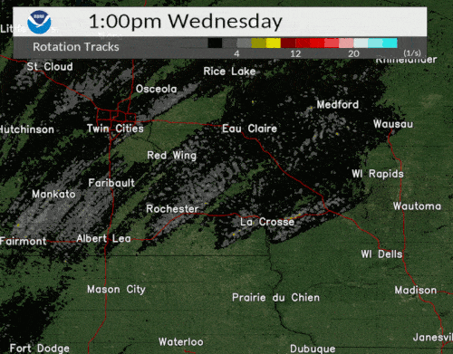
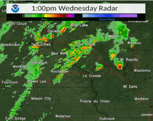 Radar Reflectivity Loop (1-7 pm CDT) |
Tornadoes:
|
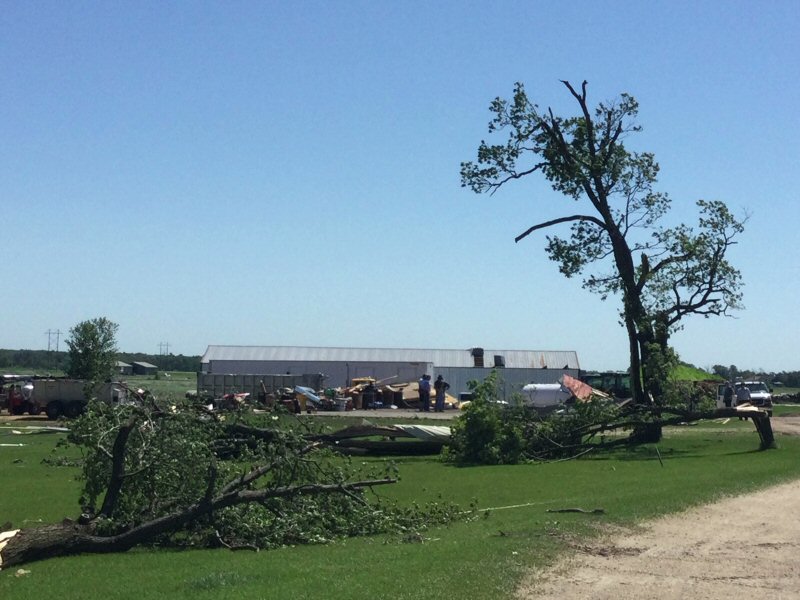
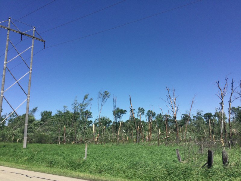
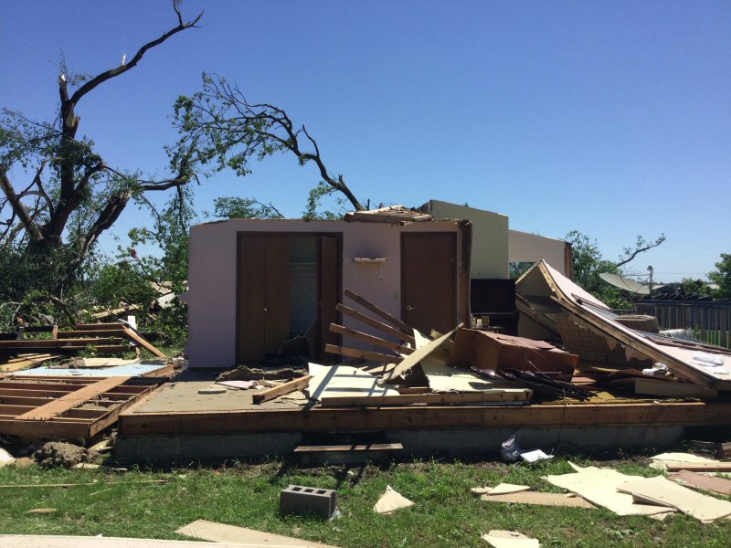
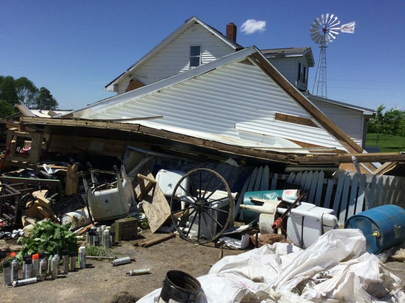
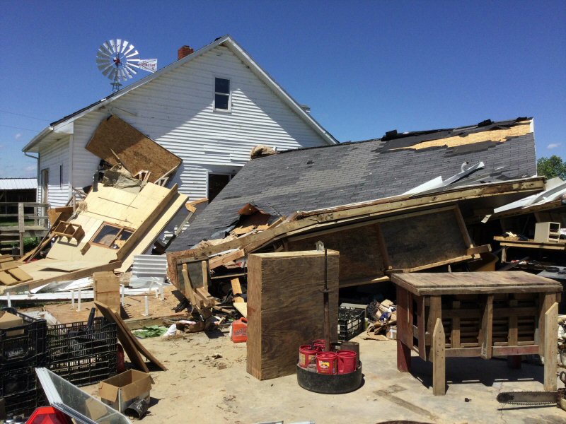
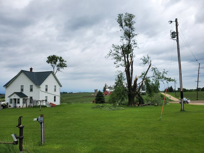
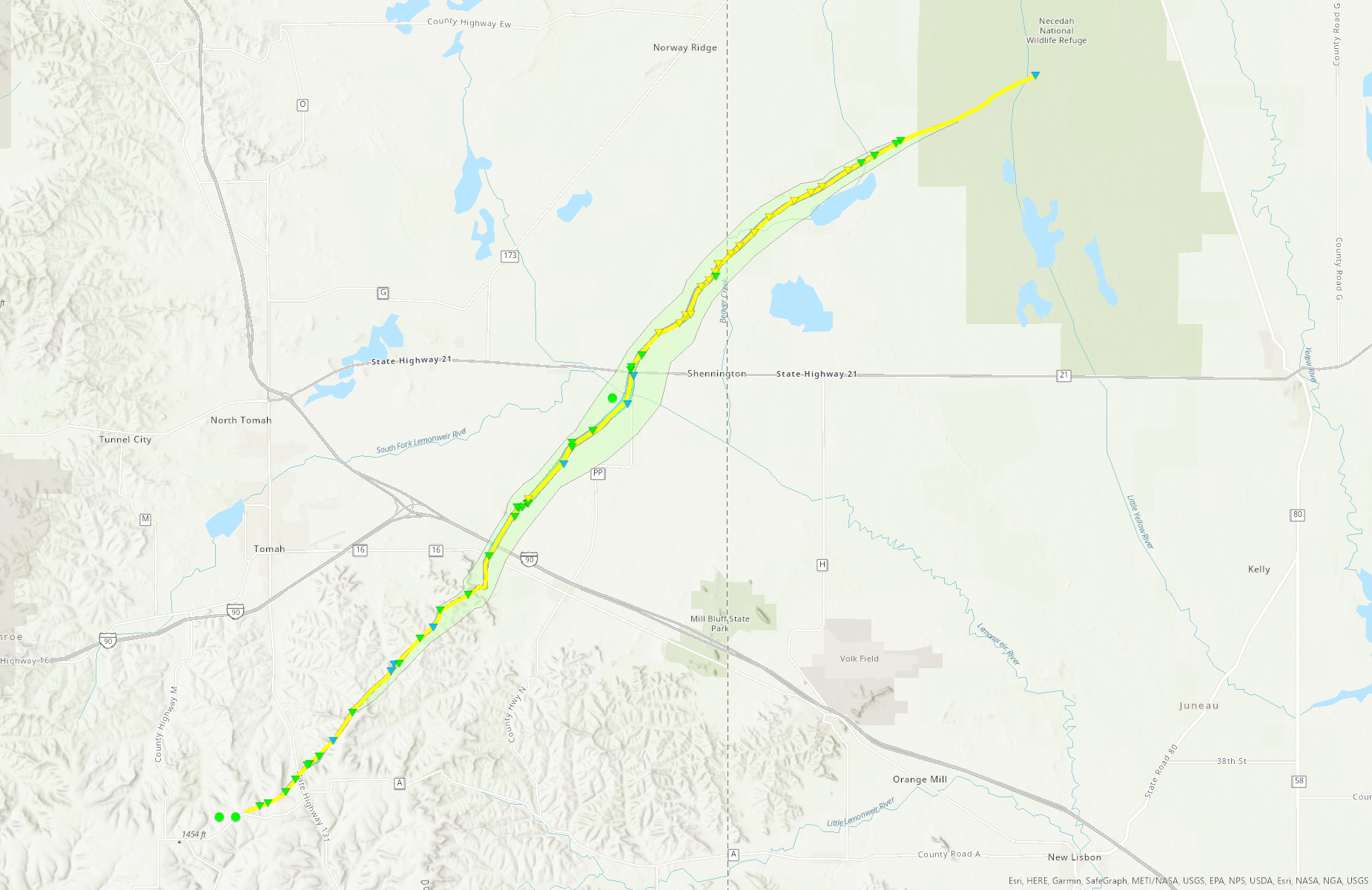
Tornado - WYEVILLE, WI
|
||||||||||||||||
|
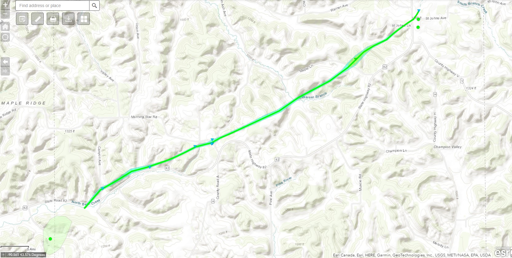
Tornado - LA FARGE, WI
|
||||||||||||||||
|
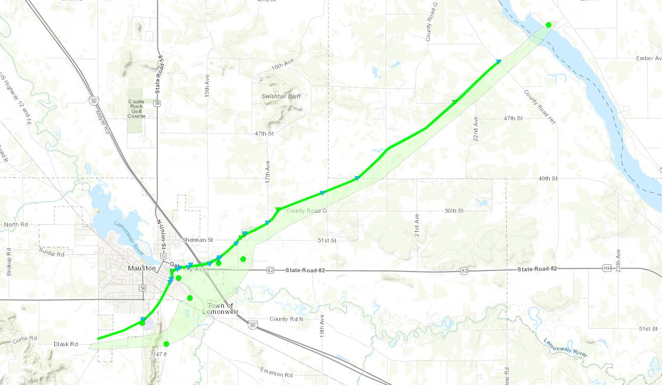
Tornado - MAUSTON, WI
|
||||||||||||||||
The Enhanced Fujita (EF) Scale classifies tornadoes into the following categories:
| EF0 Weak 65-85 mph |
EF1 Moderate 86-110 mph |
EF2 Significant 111-135 mph |
EF3 Severe 136-165 mph |
EF4 Extreme 166-200 mph |
EF5 Catastrophic 200+ mph |
 |
|||||
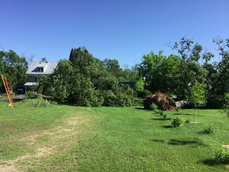
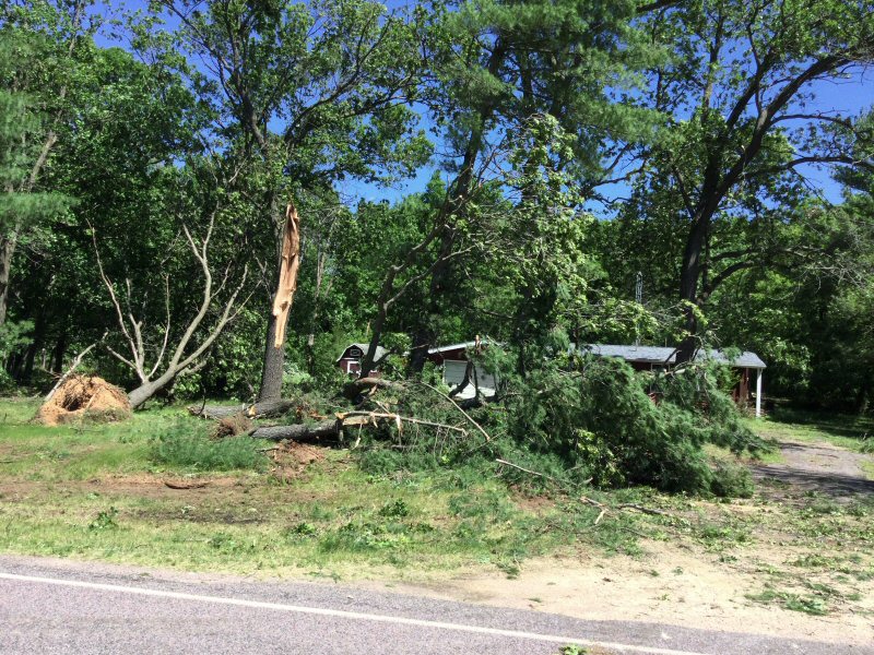
Photos & Video:
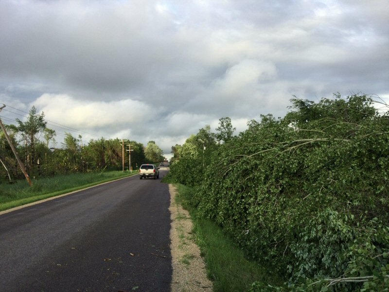
Wyeville, WI Tornado
 |
 |
 |
 |
| Just northeast of I-90 near HWY N (NWS La Crosse) |
Just northeast of I-90 on Grosbeak Ave (NWS La Crosse) |
Just northeast of I-90 on Grosbeak Ave (NWS La Crosse) |
Just northeast of I-90 on Grosbeak Ave (NWS La Crosse) |
 |
 |
 |
|
| Just northeast of I-90 / Grosbeak Ave (NWS La Crosse) |
Just northeast of I-90 on Fountain Ave (NWS La Crosse) |
East of Wyeville on Excelsior Rd (NWS La Crosse) |
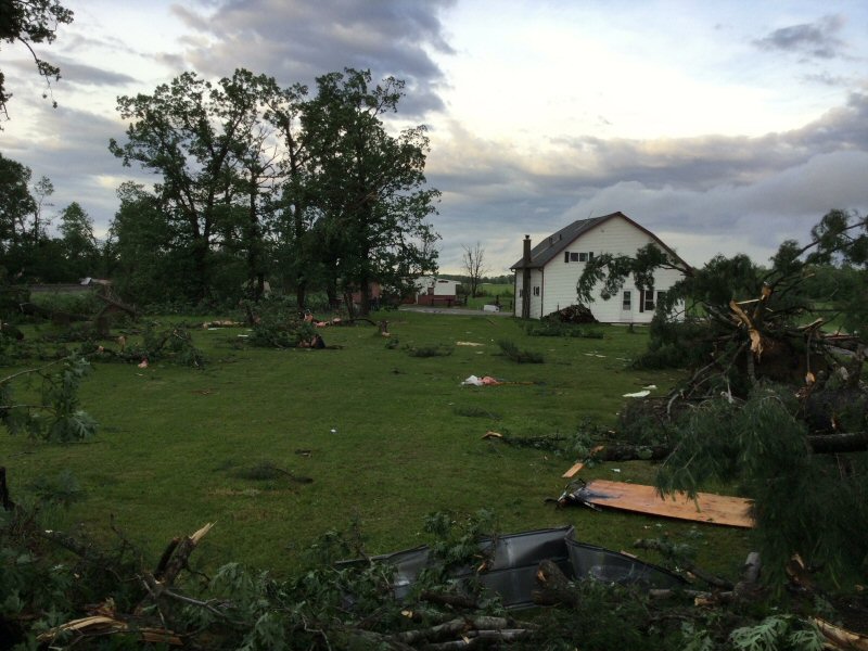
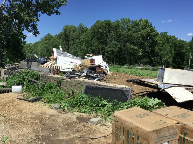
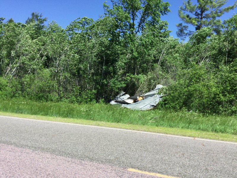
La Farge, WI Tornado
 |
 |
 |
 |
| East, northeast of La Farge (NWS La Crosse) |
East, northeast of La Farge (NWS La Crosse) |
East, northeast of La Farge (NWS La Crosse) |
La Farge, WI (Sota Storm Chasers) |
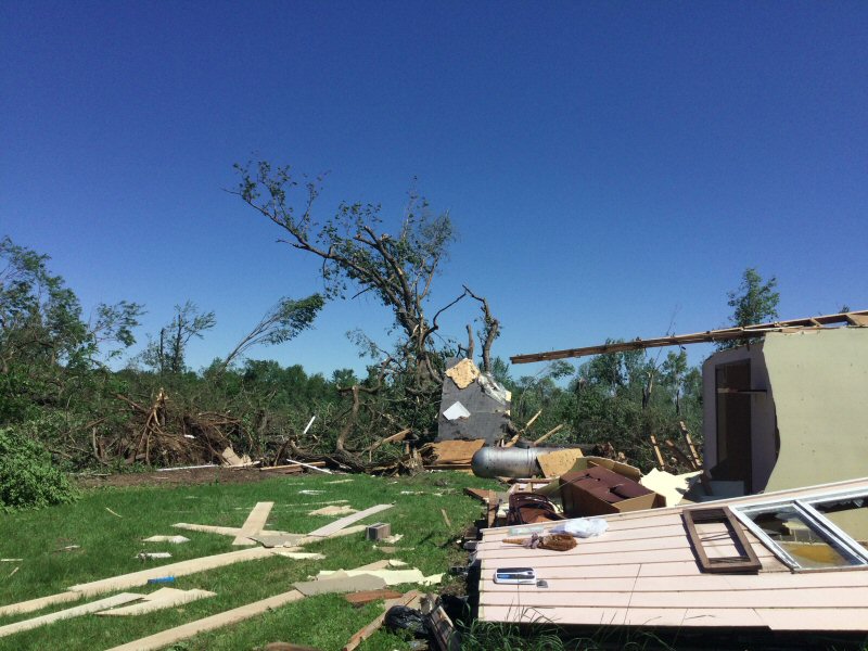
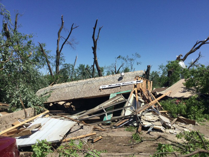
Mauston, WI Tornado
 |
 |
 |
 |
| Roosevelt, St (NWS La Crosse) |
Just off McEvoy St (NWS La Crosse) |
Commercial Ave (NWS La Crosse) |
Just north of County Rd G (NWS La Crosse) |
 |
 |
 |
 |
| Just north of County Rd G, northeast of Mauston (NWS La Crosse) |
Just north of County Rd G, northeast of Mauston (NWS La Crosse) |
Mauston, WI (Sean Macaday) |
Mauston, WI (Sean Macaday) |
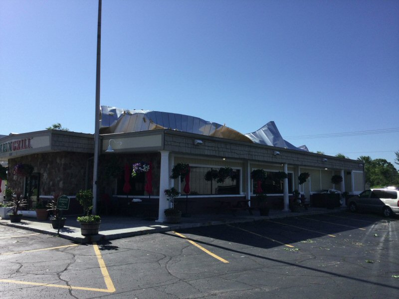
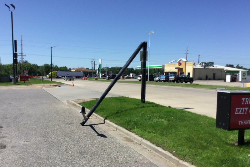
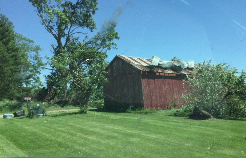
Other
 |
|||
| Caledonia, MN (Michael Lundt) |
Radar:
 |
 |
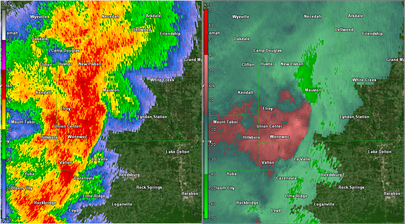 |
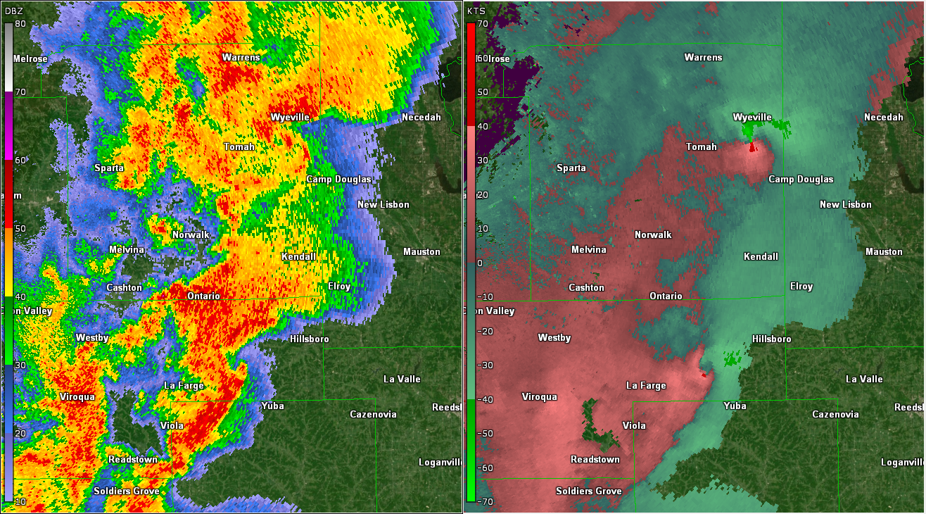
| Rotational Tracks - Provides a history of the intensity and spatial coverage of strong storm circulations that may be associated with mesocyclones, tornadoes, and/or damaging winds. | Severe storms/tornadoes ~4:12 pm (left: reflectivity - right: storm relative velocity) | Severe storms/tornado ~443 pm (left: reflectivity - right: storm relative velocity) |
Storm Reports
PRELIMINARY LOCAL STORM REPORT
NATIONAL WEATHER SERVICE LA CROSSE WI
914 PM CDT WED JUN 15 2022
..TIME... ...EVENT... ...CITY LOCATION... ...LAT.LON...
..DATE... ....MAG.... ..COUNTY LOCATION..ST.. ...SOURCE....
..REMARKS..
1010 AM TSTM WND DMG 2 NW RUDD 43.15N 92.93W
06/15/2022 FLOYD IA LAW ENFORCEMENT
TREES AND POWER LINES DOWNED.
1020 AM TSTM WND DMG 1 WNW COLWELL 43.17N 92.61W
06/15/2022 FLOYD IA TRAINED SPOTTER
BRANCHES AROUND 3 INCHES IN DIAMETER DOWN
WITH PEA SIZE HAIL. HALF AN INCH OF RAIN IN
5 MINUTES.
1030 AM HAIL FOUNTAIN 43.74N 92.13W
06/15/2022 E1.00 INCH FILLMORE MN TRAINED SPOTTER
DIME UP TO QUARTER SIZED HAIL.
1035 AM HAIL 1 S ALTA VISTA 43.17N 92.42W
06/15/2022 E0.88 INCH CHICKASAW IA TRAINED SPOTTER
TORRENTIAL RAINFALL AS WELL.
1041 AM HAIL DAVIS CORNERS 43.36N 92.30W
06/15/2022 E0.70 INCH HOWARD IA LAW ENFORCEMENT
1045 AM HAIL LIME SPRINGS 43.45N 92.28W
06/15/2022 E0.70 INCH HOWARD IA LAW ENFORCEMENT
1052 AM HAIL CRESCO 43.37N 92.12W
06/15/2022 E0.70 INCH HOWARD IA LAW ENFORCEMENT
1102 AM TSTM WND DMG 1 S HARMONY 43.54N 92.01W
06/15/2022 FILLMORE MN FIRE DEPT/RESCUE
REPORTS OF TREES DOWN AND SOME STRUCTURAL
DAMAGE JUST SOUTH OF HARMONY.
1134 AM TSTM WND DMG CALEDONIA 43.63N 91.50W
06/15/2022 HOUSTON MN LAW ENFORCEMENT
TREES AND POWER LINES DOWN JUST TO THE
NORTHWEST OF CALEDONIA.
1150 AM HAIL STODDARD 43.66N 91.22W
06/15/2022 M1.00 INCH VERNON WI EMERGENCY MNGR
1153 AM TSTM WND DMG 4 SSE LA CROSSE 43.77N 91.22W
06/15/2022 LA CROSSE WI BROADCAST MEDIA
CORRECTS PREVIOUS TSTM WND DMG REPORT FROM 4
SSE LA CROSSE. NUMEROUS TREES AND BRANCHES
DOWN, INCLUDING ONE LARGE TREE UPROOTED.
1200 PM HAIL 3 W SAINT JOSEPH 43.78N 91.10W
06/15/2022 M0.25 INCH LA CROSSE WI PUBLIC
1215 PM HAIL 1 S SPARTA 43.93N 90.81W
06/15/2022 M0.50 INCH MONROE WI PUBLIC
1217 PM HAIL 2 SSW SPARTA 43.92N 90.82W
06/15/2022 E0.75 INCH MONROE WI STORM CHASER
1221 PM HAIL 1 E SPARTA 43.94N 90.78W
06/15/2022 E0.70 INCH MONROE WI PUBLIC
1239 PM HAIL 1 N TOMAH 44.00N 90.50W
06/15/2022 M0.25 INCH MONROE WI PUBLIC
1243 PM HAIL 2 NW ONALASKA 43.91N 91.23W
06/15/2022 U0.50 INCH LA CROSSE WI PUBLIC
REPORT FROM MPING: HALF-INCH (0.50 IN.).
0343 PM TSTM WND GST PATCH GROVE 42.94N 90.97W
06/15/2022 M65 MPH GRANT WI FIRE DEPT/RESCUE
ALSO REPORTED PEA SIZE HAIL.
0406 PM HAIL 1 SSE TOMAH 43.97N 90.50W
06/15/2022 E1.00 INCH MONROE WI PUBLIC
0412 PM TSTM WND DMG 6 NNE WILTON 43.90N 90.49W
06/15/2022 MONROE WI AMATEUR RADIO
TREES DOWNS BLOCKING ROAD AT COUNTY A AND
STATE HIGHWAY 131.
0418 PM TSTM WND DMG 3 ENE NORWALK 43.86N 90.57W
06/15/2022 MONROE WI PUBLIC
TREES DOWN AND SMALL SHED DAMAGED. COUNTY U
AND KEATS ROAD.
0424 PM TSTM WND DMG 1 NE WYEVILLE 44.04N 90.37W
06/15/2022 MONROE WI PUBLIC
TREE DE-BARKING DAMAGE.
0429 PM TSTM WND DMG 3 W PLATTEVILLE 42.75N 90.54W
06/15/2022 GRANT WI PUBLIC
REPORT FROM MPING: 1-INCH TREE LIMBS BROKEN;
SHINGLES BLOWN OFF.
0447 PM TORNADO MAUSTON 43.80N 90.08W
06/15/2022 UF1 JUNEAU WI LAW ENFORCEMENT
CORRECTS PREVIOUS TSTM WND DMG REPORT FROM
MAUSTON. CONFIRMED TORNADO BY SPOTTER.
DAMAGE TO HOSPITAL AND GROUNDS.
0450 PM TSTM WND DMG MAUSTON 43.80N 90.08W
06/15/2022 JUNEAU WI BROADCAST MEDIA
FLIPPED TRAILERS AND POLES DOWN. ROOFS BLOWN
OVER. TIME ESTIMATED FROM RADAR.
0458 PM TSTM WND DMG MAUSTON 43.80N 90.07W
06/15/2022 JUNEAU WI PUBLIC
REPORT FROM MPING: 3-INCH TREE LIMBS BROKEN;
POWER POLES BROKEN.
0501 PM TSTM WND DMG 3 ENE WHITE CREEK 43.84N 89.80W
06/15/2022 ADAMS WI PUBLIC
TREES DOWN AND IRRIGATION EQUIPMENT FLIPPED
NEAR EASTON. REPORT VIA NWS MKX.
0502 PM TSTM WND DMG LYNDON STATION 43.71N 89.90W
06/15/2022 JUNEAU WI PUBLIC
TREE BRANCHES DOWN, PEA-SIZED HAIL.
0504 PM FUNNEL CLOUD 1 E ROCKLAND 43.91N 90.90W
06/15/2022 MONROE WI TRAINED SPOTTER
SPOTTER REPORTED ROTATING WALL CLOUD WITH
POSSIBLE FUNNELS.
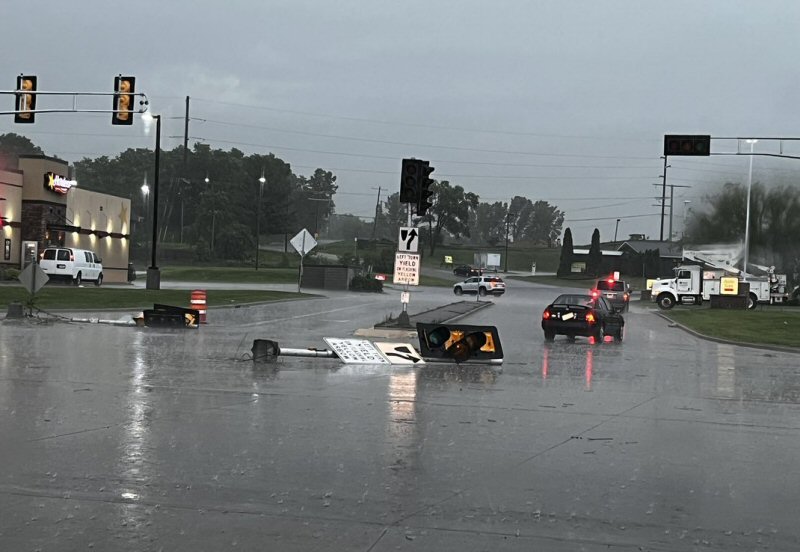
0505 PM TSTM WND DMG MAUSTON 43.80N 90.08W
06/15/2022 JUNEAU WI PUBLIC
STREET SIGNS DOWN, SIGNAL LIGHTS DAMAGED.
0510 PM TSTM WND GST LIVINGSTON 42.90N 90.43W
06/15/2022 M52 MPH GRANT WI FIRE DEPT/RESCUE
0515 PM FUNNEL CLOUD 1 E ADAMS 43.96N 89.80W
06/15/2022 ADAMS WI PUBLIC
0515 PM TSTM WND DMG 4 SSE VALLEY 43.60N 90.51W
06/15/2022 VERNON WI EMERGENCY MNGR
STRUCTURE DAMAGE TO A HOUSE AND TWO CAMPERS.
DAMAGE CONTINUES TOWARDS HWY 82 AND CANNON
AVE.
0518 PM TSTM WND DMG GRAND MARSH 43.89N 89.71W
06/15/2022 ADAMS WI PUBLIC
REPORT FROM MPING: 1-INCH TREE LIMBS BROKEN;
SHINGLES BLOWN OFF.
0520 PM TSTM WND DMG 1 E MAUSTON 43.80N 90.05W
06/15/2022 JUNEAU WI PUBLIC
REPORT FROM MPING: 3-INCH TREE LIMBS BROKEN;
POWER POLES BROKEN.
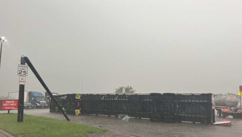
0534 PM TSTM WND DMG 2 S TOMAH 43.96N 90.51W
06/15/2022 MONROE WI PUBLIC
MULTIPLE SEMIS TIPPED OVER ON I-90/94,
MOSTLY IN EASTBOUND LANE.
0545 PM TSTM WND GST GLEN HAVEN 42.83N 91.07W
06/15/2022 E50 MPH GRANT WI EMERGENCY MNGR
&&
Rain Reports
Public Information Statement
National Weather Service La Crosse WI
911 PM CDT Wed Jun 15 2022

...PRECIPITATION REPORTS LAST 24 HOURS...

Location                     Amount    Time/Date       Lat/Lon

...Iowa...

...Allamakee County...
3 SE Waterville              0.58 in   0807 PM 06/15   43.17N/91.24W

...Chickasaw County...
Ionia 2W                     0.74 in   0700 PM 06/15   43.03N/92.50W
NEW HAMPTON                  0.59 in   0856 PM 06/15   43.05N/92.30W
Ionia 2W                     0.51 in   0845 PM 06/15   43.03N/92.50W

...Clayton County...
Mcgregor                     0.55 in   0904 PM 06/15   43.02N/91.19W
Garber                       0.42 in   0815 PM 06/15   42.74N/91.26W

...Fayette County...
Eldorado 1E - Turkey River   0.70 in   0800 PM 06/15   43.05N/91.81W
Eldorado 1E - Turkey River   0.32 in   0845 PM 06/15   43.05N/91.81W

...Floyd County...
CHARLES CITY                 1.28 in   0858 PM 06/15   43.07N/92.68W
Charles City                 0.55 in   0830 PM 06/15   43.06N/92.67W

...Howard County...
Saratoga                     1.00 in   1030 AM 06/15   43.35N/92.42W
Riceville                    0.74 in   0845 PM 06/15   43.36N/92.48W

...Mitchell County...
St.Ansgar                    2.78 in   0856 PM 06/15   43.38N/92.92W

...Winneshiek County...
Spillville                   0.83 in   0800 PM 06/15   43.21N/91.95W
Decorah                      0.78 in   0700 PM 06/15   43.30N/91.80W
7 ENE Decorah                0.78 in   0921 AM 06/15   43.34N/91.64W
Decorah                      0.76 in   0845 PM 06/15   43.30N/91.80W
1 ENE Bluffton               0.72 in   0845 PM 06/15   43.41N/91.90W
1 ENE Bluffton               0.67 in   0500 PM 06/15   43.41N/91.90W
Spillville                   0.61 in   0830 PM 06/15   43.21N/91.95W

...Minnesota...

...Dodge County...
Hayfield                     0.53 in   0427 PM 06/15   43.89N/92.85W

...Fillmore County...
Chatfield 0.7 SW             1.08 in   1030 AM 06/15   43.84N/92.20W
1 NNW Fillmore               0.89 in   0830 PM 06/15   43.76N/92.27W
Lanesboro                    0.86 in   0830 PM 06/15   43.72N/91.98W

...Houston County...
Mound Prairie                1.11 in   0845 PM 06/15   43.78N/91.45W
Houston                      1.06 in   0857 PM 06/15   43.77N/91.58W
Mound Prairie                0.66 in   0100 PM 06/15   43.78N/91.45W
Hokah                        0.54 in   0900 PM 06/15   43.80N/91.43W

...Mower County...
Lansing - Cedar River        0.74 in   0800 PM 06/15   43.75N/92.96W
Austin                       0.64 in   0857 PM 06/15   43.65N/93.00W
Lansing - Cedar River        0.49 in   0830 PM 06/15   43.75N/92.96W
Dobbins Creek                0.46 in   0830 PM 06/15   43.68N/92.94W

...Olmsted County...
Rochester                    1.29 in   0900 PM 06/15   44.04N/92.44W
Rochester                    0.87 in   0855 PM 06/15   44.09N/92.49W
Rochester                    0.80 in   0900 PM 06/15   44.05N/92.53W
Rochester                    0.77 in   0855 PM 06/15   44.09N/92.51W
3 ENE Rochester              0.74 in   0830 PM 06/15   44.03N/92.43W
Byron                        0.73 in   0845 PM 06/15   44.04N/92.64W
Rochester-Cascade Creek      0.72 in   0830 PM 06/15   44.03N/92.47W
Rochester International Airp 0.70 in   0854 PM 06/15   43.90N/92.50W
Rochester                    0.68 in   0900 PM 06/15   44.05N/92.45W
Rochester                    0.66 in   0845 PM 06/15   44.18N/92.41W
Rochester 5.5 N              0.62 in   0930 AM 06/15   44.10N/92.47W
Rochester 2.3 WSW            0.59 in   1000 AM 06/15   44.01N/92.52W
4 NNW Rochester              0.52 in   0930 AM 06/15   44.07N/92.49W
Eyota 2NE                    0.50 in   0830 PM 06/15   44.02N/92.20W
Rochester-Beltline Bear Cree 0.48 in   0830 PM 06/15   44.01N/92.45W
1 W Oronoco                  0.38 in   0830 PM 06/15   44.17N/92.55W
3 W Rochester                0.37 in   0830 PM 06/15   44.02N/92.53W

...Wabasha County...
Plainview                    0.85 in   0856 PM 06/15   44.17N/92.17W
1 N Kellogg                  0.81 in   0800 PM 06/15   44.32N/92.00W
Wabasha                      0.57 in   0858 PM 06/15   44.30N/92.00W
Lake City                    0.40 in   0845 PM 06/15   44.44N/92.28W
Lake City                    0.36 in   0854 PM 06/15   44.32N/92.44W

...Winona County...
Winona 5.1 WSW               1.06 in   0300 PM 06/15   44.03N/91.77W
Beaver                       0.84 in   0845 PM 06/15   44.15N/92.00W
Lawrence                     0.71 in   0855 PM 06/15   43.88N/91.34W
Beaver                       0.69 in   0100 PM 06/15   44.15N/92.00W
1 WSW Elba                   0.68 in   0845 PM 06/15   44.09N/92.03W
3 SW Elba                    0.61 in   0830 PM 06/15   44.06N/92.05W
3 NE Nodine                  0.49 in   0830 PM 06/15   43.94N/91.41W
Whitewater State Park        0.46 in   0830 PM 06/15   44.05N/92.05W

...Wisconsin...

...Buffalo County...
Mondovi                      1.03 in   0700 PM 06/15   44.56N/91.67W

...Crawford County...
De Soto                      0.55 in   0856 PM 06/15   43.42N/91.19W

...Grant County...
Platteville                  0.95 in   0855 PM 06/15   42.74N/90.46W
Muscoda                      0.65 in   0855 PM 06/15   43.19N/90.46W

...Jackson County...
1 E Black River Falls        1.22 in   0715 PM 06/15   44.30N/90.73W

...Juneau County...

New Lisbon                   1.36 in   0845 PM 06/15   43.87N/90.17W
Mauston                      0.96 in   0757 PM 06/15   43.80N/90.07W
Necedah                      0.76 in   0848 PM 06/15   44.03N/90.08W
Volk Field                   0.60 in   0856 PM 06/15   43.92N/90.27W

...La Crosse County...
Burns                        1.21 in   0858 PM 06/15   43.91N/90.97W
La Crosse                    1.13 in   0808 PM 06/15   43.82N/91.19W
Onalaska                     0.80 in   0857 PM 06/15   43.89N/91.18W
La Crosse                    0.78 in   0858 PM 06/15   43.81N/91.25W
La Crosse 1.3 SSE            0.70 in   1200 PM 06/15   43.81N/91.22W
La Crosse Regional Airport   0.61 in   0853 PM 06/15   43.88N/91.25W

...Monroe County...
Sparta/Fort McCoy Airport    1.40 in   0858 PM 06/15   43.97N/90.73W

...Taylor County...
Medford                      1.40 in   0900 PM 06/15   45.30N/90.30W
3 NE Lublin                  1.23 in   0714 PM 06/15   45.11N/90.69W
Medford Airport              0.75 in   0855 PM 06/15   45.10N/90.30W
Westboro                     0.45 in   0300 PM 06/15   45.37N/90.31W

...Trempealeau County...
Osseo 0.4 E                  1.31 in   0700 PM 06/15   44.58N/91.21W
Trempealeau                  1.17 in   0859 PM 06/15   44.07N/91.51W
0.8 SW Pigeon Falls (IFLOWS) 0.94 in   0555 PM 06/15   44.42N/91.22W
0.9 S Independence (IFLOWS)  0.75 in   0359 PM 06/15   44.35N/91.42W
Blair (IFLOWS)               0.75 in   0332 PM 06/15   44.30N/91.23W
Whitehall (IFLOWS)           0.63 in   0309 PM 06/15   44.37N/91.32W

...Vernon County...
La Farge                     1.01 in   0845 PM 06/15   43.60N/90.63W
Ontario                      0.99 in   0745 PM 06/15   43.72N/90.59W
Genoa                        0.62 in   0855 PM 06/15   43.56N/91.22W

Observations are collected from a variety of sources with varying
equipment and exposures. We thank all volunteer weather observers
for their dedication. Not all data listed are considered official.

$$
Services
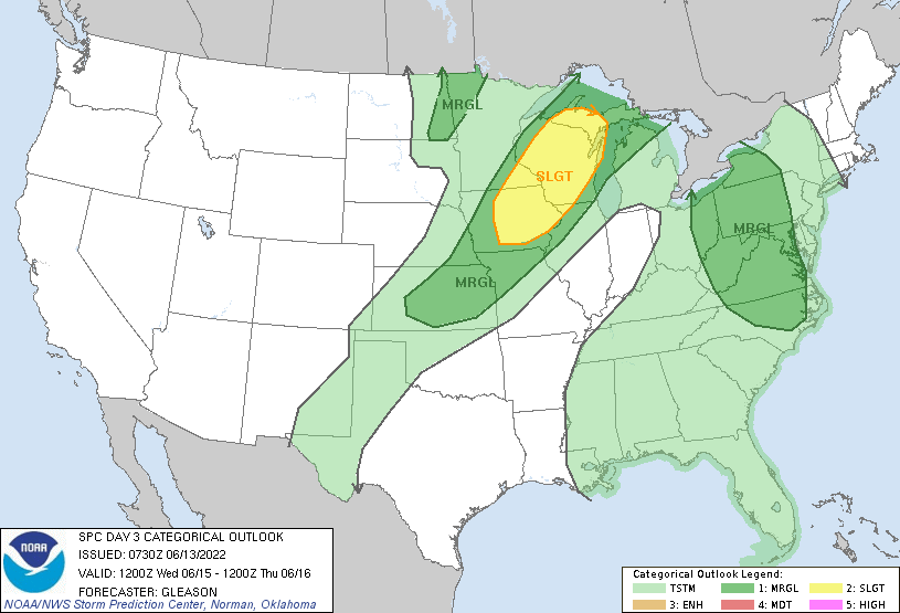
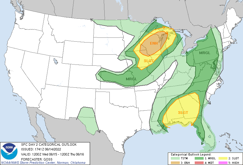
Storm Prediction Center Outlooks
 |
 |
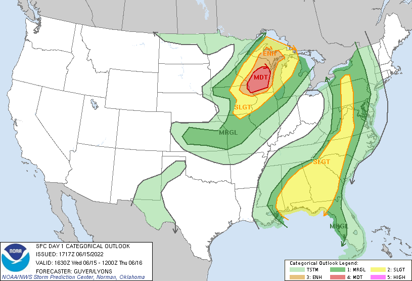 |
| Day 3 Outlook (issued June 13th) | Day 2 Outlook (issued June 14th) | Day 1 Outlook (issued June 15th) |
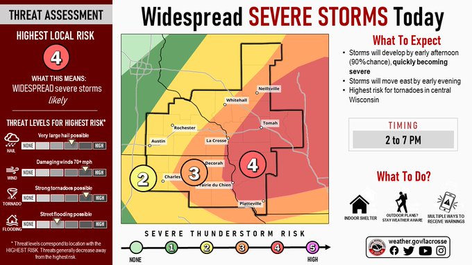
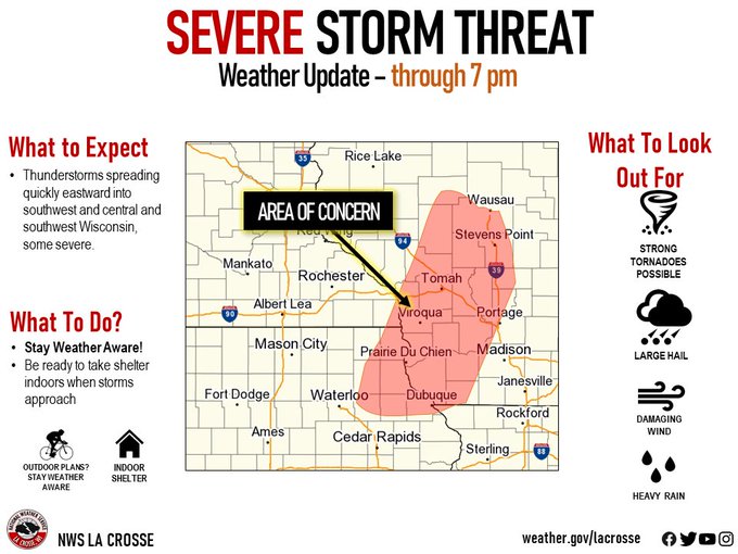
NWS La Crosse Graphics
 |
 |
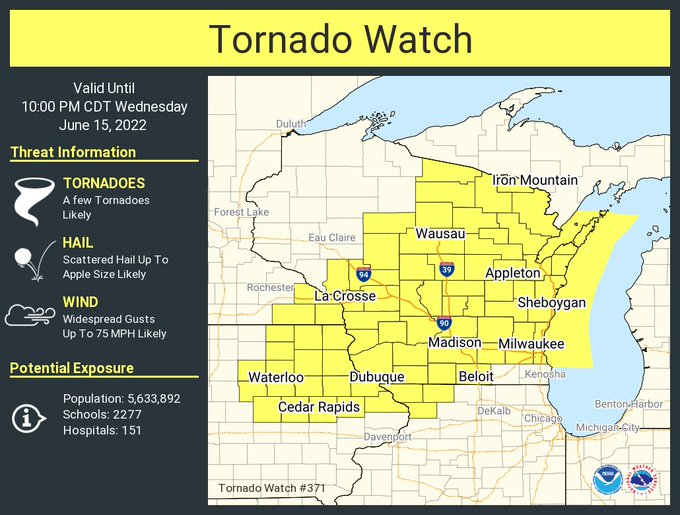 |
| Informative graphic developed by NWS La Crosse | Graphicast as storms approach | Tornado Watch issued that day |
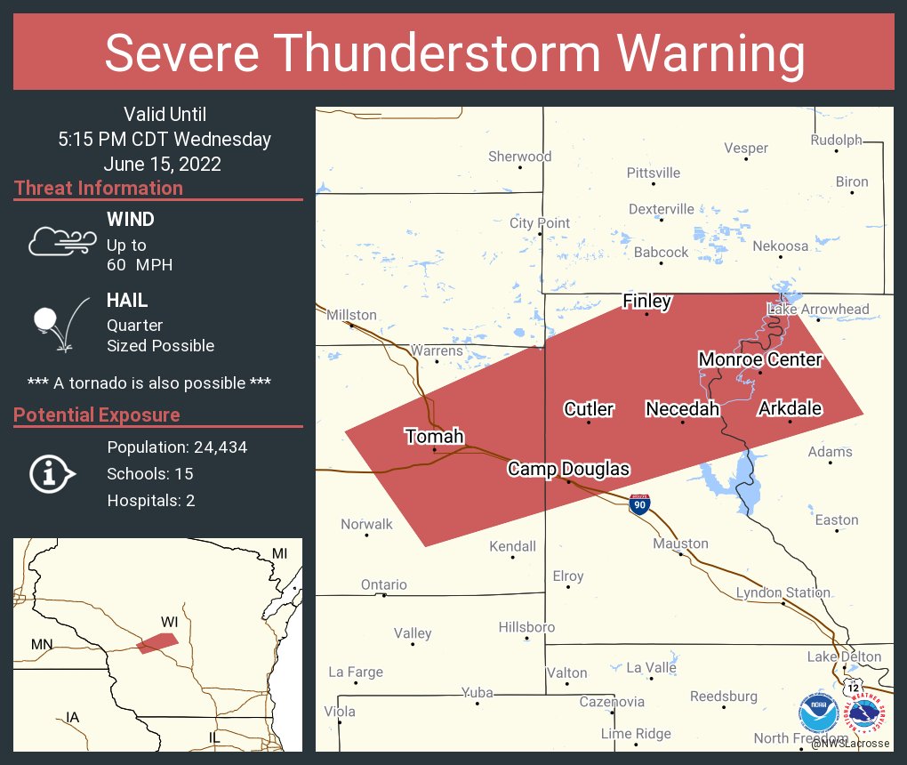
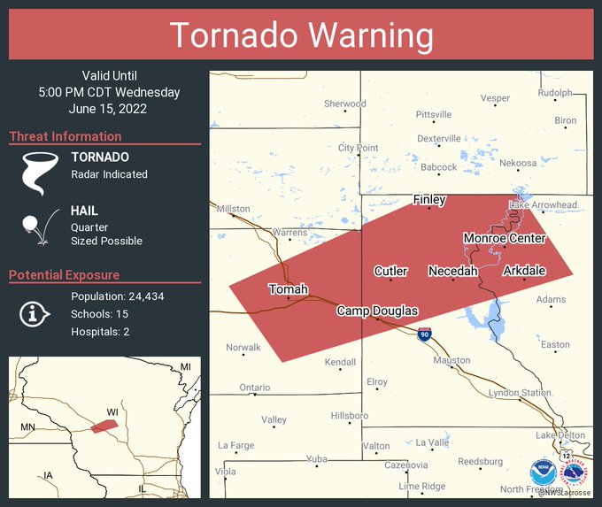
Warnings Issued for western/central Wisconsin
 |
 |
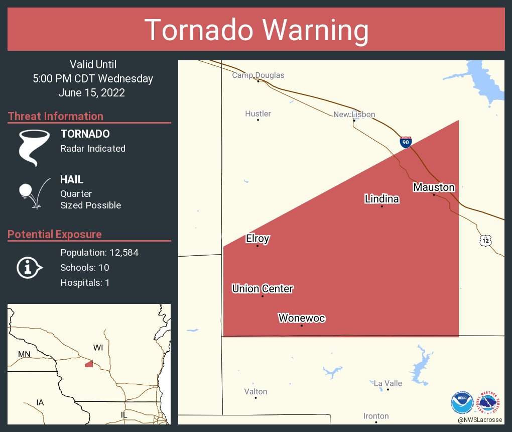 |
| Severe Thunderstorm Warning | Tornado Warning (Tomah/Wyeville) | Tornado Warning (Mauston Area) |
 |
Media use of NWS Web News Stories is encouraged! Please acknowledge the NWS as the source of any news information accessed from this site. |
|


 Weather Story
 Weather Map
 Local Radar