
Tropical Depression Two is expected to gradually strengthen and could bring tropical storm conditions to the Florida Panhandle beginning late Monday. Areas of flash flooding will be possible through Thursday along the eastern and central Gulf Coast. Severe thunderstorms will develop and move along a cold front crossing the Upper Midwest Monday, and through the Ohio Valley/Mid-Atlantic on Tuesday. Read More >

| Cleveland County, OK Tornadoes Prior to 1950 | |||||||||
| # | Date | Time (CST) |
Path Length (miles) |
Path Width (yards) |
F-Scale | Killed | Injured | County | Path |
|---|---|---|---|---|---|---|---|---|---|
| 04/25/1893 | 1645 | 0 | 0 | Cleveland | 3.5 E "Case" (~15 E Moore) | ||||
| 04/25/1893 | 1830 | 45 | 31 | many | Cleveland/ Pottawatomie | SW of Moore - near "Case" (12 E Moore) | |||
| 04/08/1896 | 1500 | 12 | 100 | 0 | 3 | Cleveland | 4 NW "Linden" (Linden=7 S Newalla) | ||
| 05/16/1910 | 1 | 1 | Cleveland | 15 NE Norman | |||||
| 03/28/1924 | 1545 | 50 | 200 | 8 | 60 | Cleveland/ Pottawatomie/ Lincoln | Near Noble - Shawnee - near Prague | ||
| 06/09/1937 | 1630 | 35 | 320 | 4 | 7 | Canadian/ Cleveland | W of Union City - SE of Mustang - near Moore (possibly series) | ||
| 09/26/1945 | 1805 | 67 | 0 | 0 | McClain/ Cleveland/ Oklahoma | Newcastle - Norman - S OKC | |||
| 04/30/1949 | 1455 | 52* | 250 | 3 | 56 | McClain/ Cleveland/ Pottawatomie/ Lincoln | 5 S Blanchard - W of Norman; S of McLoud - E of Meeker (likely separate events) | ||
| Cleveland County, OK Tornadoes (1950-Present*) | |||||||||
| # | Date | Time (CST) |
Path Length (miles) |
Path Width (yards) |
F-Scale | Killed | Injured | County | Path |
| 1 | 02/19/1951 | 2200 | 0.1 | 100 | F0 | 0 | 0 | Cleveland | 4 S Norman |
| 2 | 04/05/1951 | 1320 | 6 | 127 | F2 | 0 | 0 | Cleveland | NW of Norman (near Newcastle) - NW of Moore |
| 3 | 03/13/1953 | 1930 | 1.3 | 250 | F2 | 0 | 0 | Cleveland | 11 E Norman |
| 4 | 05/26/1955 | 0300 | 12 | 70 | F1 | 0 | 0 | Cleveland | near Norman |
| 5 | 04/28/1956 | 1420 | 35 | 10 | F1 | 0 | 0 | Grady/ McClain/ Cleveland | 5 S Chickasha - 3 E Norman |
| 6 | 09/14/1957 | 1730 | 68 | 440 | F4 | 2 | 6 | Cleveland/ Pottawatomie/ Seminole/ Hughes | Southern Cleveland County NW of Wayne - near Sacred Heart - near Konawa - near Wetumka |
| 7 | 04/28/1960 | 2058 | 8 | 500 | F2 | 0 | 0 | Cleveland | W and N of Moore |
| 8 | 04/28/1960 | 2100 | 0.1 | 10 | F2 | 0 | 0 | Cleveland | 13 NE Lexington |
| 9 | 04/28/1960 | 2105 | 4 | 400 | F2 | 0 | 6 | Cleveland | Moore |
| 10 | 05/04/1960 | 1945 | 5 | 50 | F2 | 0 | 0 | Cleveland | Noble - 5 NE Noble |
| 11 | 05/05/1960 | 1500 | 102 | 400 | F3 | 0 | 0 | Cleveland/ Pottawatomie/ Lincoln/ Creek/ Tulsa | SW of Corbett - Tribbey- Macomb -2 W Tecumseh; near Bellmont - Depew - 4 W Sand Springs [tornado family] |
| 12 | 05/19/1960 | 1625 | 0.1 | 10 | F2 | 0 | 0 | Cleveland | Moore |
| 13 | 05/06/1961 | 2350 | 0.1 | 10 | F? | 0 | 0 | Cleveland | Between Moore and Norman |
| 14 | 05/07/1961 | 0045 | 0.1 | 10 | F? | 0 | 0 | Cleveland | Near Moore |
| 15 | 04/27/1962 | 0040 | 0.1 | 10 | F? | 0 | 0 | Cleveland | 1 SSW Norman |
| 16 | 05/26/1962 | 2058 | 7 | 100 | F2 | 0 | 0 | McClain/ Cleveland | 1 NE- ~5 E Goldsby |
| 17 | 09/11/1963 | 1515 | 1 | 50 | F1 | 0 | 0 | Cleveland | SW edge and S of Noble |
| 18 | 04/03/1964 | 1840 | 0.1 | 10 | F? | 0 | 0 | Cleveland | SW Norman (3 SW National Severe Storms Laboratory) |
| 19 | 08/31/1965 | 1415 | 12 | 50 | F0 | 0 | 0 | Oklahoma/ Cleveland | near SW 80th/May - NW Corner of Moore - SE Oklahoma City |
| 20 | 08/31/1965 | 1420 | 0.1 | 10 | F0 | 0 | 0 | Cleveland | Oklahoma City (near S May and the S Canadian River) |
| 21 | 05/17/1966 | 2215 | 0.4 | 17 | F0 | 0 | 0 | Cleveland | Norman (near Berry and Dorchester) |
| 22 | 07/23/1966 | 0534 | 0.1 | 10 | F0 | 0 | 0 | Cleveland | near Noble |
| 23 | 10/05/1970 | 1540 | 24 | 200 | F2 | 0 | 1 | Cleveland/ Pottawatomie | 5 NE Lexington - 8 SE Tecumseh |
| 24 | 12/29/1972 | 2015 | 15 | 40 | F2 | 0 | 0 | McClain/ Cleveland | 10 SW Purcell - 4 ESE Lexington |
| 25 | 06/04/1973 | 1912 | 0.4 | 17 | F0 | 0 | 0 | Cleveland | Norman (3 W NSSL) |
| 26 | 11/19/1973 | 1930 | 24 | 500 | F3 | 5 | 36 | McClain/ Cleveland/ Oklahoma | Blanchard - Moore - Del City - SE Oklahoma City |
| 27 | 02/18/1974 | 1448 | 0.1 | 17 | F0 | 0 | 0 | Cleveland | 5 SE Noble |
| 28 | 08/01/1974 | 1540 | 1 | 50 | F1 | 0 | 0 | Cleveland | Moore (near NW 2nd/Santa Fe) |
| 29 | 05/13/1975 | 1515 | 2 | 50 | F2 | 0 | 0 | Cleveland | Oklahoma City (southeast of SW 89th/ Western) - N Moore |
| 30 | 03/10/1977 | 2050 | 5 | 77 | F1 | 0 | 0 | Cleveland | Noble - 4 NE Noble |
| 31 | 05/21/1977 | 0200 | 0.1 | 50 | F0 | 0 | 0 | Cleveland | Near Hall Park |
| 32 | 04/10/1979 | 1840 | 2 | 10 | F2 | 0 | 0 | Cleveland | 6 N Purcell |
| 33 | 04/10/1979 | 1850 | 1.5 | 40 | F2 | 0 | 0 | Cleveland | Near Noble |
| 34 | 08/19/1979 | 1400 | 0.1 | 10 | F0 | 0 | 0 | Cleveland | Far SE Oklahoma City (SE 104 and Triple X) |
| 35 | 05/17/1981 | 1646 | 4 | 100 | F1 | 0 | 0 | McClain/ Cleveland | 3 SSW Noble |
| 36 | 05/17/1981 | 1724 | 1 | 100 | F1 | 0 | 0 | Cleveland | Norman (SH-9 S of Lake Thunderbird) |
| 37 | 06/30/1981 | 1520 | 0.3 | 10 | F1 | 0 | 1 | Cleveland | Norman |
| 38 | 05/13/1983 | 2320 | 0.1 | 50 | F0 | 0 | 0 | Cleveland | 3 N Lexington |
| 39 | 11/18/1983 | 2250 | 0.2 | 17 | F1 | 0 | 0 | Cleveland | S Sections of Norman |
| 40 | 05/27/1984 | 1745 | 6 | 100 | F0 | 0 | 0 | Cleveland/ McClain | 3 S- 8 SSE Noble |
| 41 | 03/28/1988 | 1720 | 0.1 | 30 | F1 | 0 | 0 | Cleveland | SW Oklahoma City |
| 42 | 09/23/1988 | 1700 | 0.5 | 80 | F1 | 0 | 0 | Cleveland | 4 ENE Noble (near 72nd/ Post Oak) |
| 43 | 03/13/1990 | 1644-1737 | 28 | 200 | F2 | 0 | 1 | Grady/ McClain/ Cleveland | 1 W Bradley- Washington- Noble- 5 NE Noble |
| 44 | 03/13/1990 | 1731-1805 | 18 | 150 | F2 | 0 | 0 | McClain/ Cleveland | 2 W Criner- 5 SE Noble |
| 45 | 03/13/1990 | 1753 | 5 | 50 | F1 | 0 | 0 | Cleveland | Little River S.P.- 4 SW Stella |
| 46 | 03/13/1990 | 1759-1845 | 19 | 200 | F2 | 0 | 1 | Cleveland/ Pottawatomie/ Lincoln | 1 SW Stella- Stella- 4 W Meeker |
| 47 | 05/02/1991 | 1920 | 0.5 | 30 | F1 | 0 | 0 | Cleveland | Moore |
| 48 | 10/04/1998 | 1926-1928 | 1.5 | 30 | F0 | 0 | 0 | McClain/ Cleveland | N Newcastle - SW Oklahoma City |
| 49 | 10/04/1998 | 1934-1941 | 3 | 580 | F2 | 0 | 0 | Cleveland | Moore |
| 50 | 11/09/1998 | 2115-2120 | 5 | 130 | F1 | 0 | 0 | McClain/ Cleveland | 1.5 SW Purcell - Purcell - 1 NE Lexington |
| 51 | 05/03/1999 | 1726-1848 | 37 | 1760 | F5 | 36 | 583 | Grady/ McClain/ Cleveland/ Oklahoma | 2 SSW Amber - far N Newcastle - SW Oklahoma City - N Moore - S Del City - W Midwest City |
| 52 | 05/03/1999 | 1934-1952 | 9 | 30 | F1 | 0 | 0 | Cleveland/ Pottawatomie | 1 N Etowah - Pink - 2 NNE Pink |
| 53 | 05/04/1999 | 0600-0603 | 2 | 50 | F0 | 0 | 0 | Cleveland | southeast Oklahoma City (7 NNE - 9 NNE Norman; near SE149/Midwest Blvd) |
| 54 | 05/08/2003 | 1604-1608 | 2 | 100 | F0 | 0 | 0 | Cleveland | Oklahoma City [NW of SW 149th and Penn - WNW of SW 134th and Santa Fe] |
| 55 | 05/08/2003 | 1610-1638 | 17 | 700 | F4 | 0 | 134 | Cleveland/ Oklahoma | Moore - Oklahoma City (SE) - Midwest City (SE) - Choctaw [~1/2 mile N of SW 134th and Santa Fe to 1/2 mile ESE of Reno and Choctaw] (1.5 W Moore - 2.5 SSE Choctaw) |
| 56 | 06/09/2004 | 1635 | 0.3 | 20 | F0 | 0 | 0 | Cleveland | 8 E Moore (SE side of Lake Draper) |
| 57 | 05/07/2008 | 1621-1631 | 5 | 25 | EF0 | 0 | 0 | McClain/ Cleveland | 0.5 SE Goldsby - 1.5 N Noble |
| 58 | 05/13/2009 | 2141-2147 | 0.5 | 80 | EF0 | 0 | 0 | Cleveland | Stanley Draper Lake (west edge) |
| 59 | 06/12/2009 | 2123-2139 | 2 | 200 | EF1 | 0 | 0 | Cleveland | Norman (SE 24/Alameda - SE48/Lindsay) |
| 60 | 05/10/2010 | 1620-1651 | 24 | 2000 | EF4 | 2 | 49 | Cleveland/ Oklahoma | Norman (near Santa Fe/Indian Hill) - Moore (south) - Lake Draper - 1.5 SSE Harrah |
| 61 | 05/10/2010 | 1622-1627 | 4 | 250 | EF1 | 0 | 0 | Cleveland | Moore (near Broadway/Eastern - NE of SE 119th/Sunnylane) |
| 62 | 05/10/2010 | 1627 | 0.5 | 50 | EF1 | 0 | 0 | Cleveland | Moore (near SE 34th/Sooner) |
| 63 | 05/10/2010 | 1632-1659 | 22 | 880 | EF4 | 1 | 32 | Cleveland/ Pottawatomie | Norman (near SH-9/Jenkins) - Little Axe - 4 E Pink |
| 64 | 05/10/2010 | 1634-1640 | 6 | 250 | EF1 | 0 | 0 | Cleveland | Norman (south of SH-9/Chautauqua - just NW of SH-9/SE 60th) |
| 65 | 05/10/2010 | 1639-1659 | 17 | 440 | EF2 | 0 | 3 | Cleveland/ Pottawatomie | 7 ESE Noble - Norman (east) - 4 E Pink |
| 66 | 05/10/2010 | 1752-1754 | 2 | 80 | EF0 | 0 | 0 | Cleveland | 7 E - 9 E Lexington |
| 67 | 05/24/2011 | 1606-1701 | 33 | 880 | EF4 | 1 | 48 | Grady/ McClain/ Cleveland | 2 S Chickasha - Oklahoma City (near SW 149th/Portland) |
| 68 | 04/13/2012 | 1459-1512 | 6 | 600 | EF1 | 0 | 0 | McClain/ Cleveland | 4 NNW Goldsby - Norman (near NE12th/Robinson) |
| 69 | 05/19/2013 | 1700-1750 | 23 | 1500 | EF4 | 2 | 10 | Cleveland/ Pottawatomie | Norman (9 E Downtown) - 6.5 ESE McLoud |
| 70 | 05/20/2013 | 1356-1435 | 14 | 1900 | EF5 | 24 | 212 | McClain/ Cleveland | Newcastle (3 NW US-77/SH-130) - Oklahoma City (south) - Moore - 3 WNW Stanley Draper Lake Dam |
| 71 | 05/29/2013 | 1742 | 0.1 | 10 | EF1 | 0 | 0 | Cleveland | Norman (Fairfield Dr/Belmont Dr) |
| 72 | 05/31/2013 | 1842-1843 | 1 | 100 | EF1 | 0 | 0 | Cleveland | Oklahoma City (near SW 119th/Meridian) |
| 73 | 03/25/2015 | 1734-1750 | 11 | 50 | EF2 | 0 | 7 | Cleveland | 4.5 WNW - 7 SE Moore |
| 74 | 05/06/2015 | 1646 | 0.5 | 25 | EF0 | 0 | 0 | Cleveland | Norman (near 60th Ave NW/Robinson) |
| 75 | 05/06/2015 | 1653-1710 | 3 | 1000 | EF1 | 0 | 0 | Cleveland | Norman (36th Ave NW//Rock Creek - 36th Ave NW/Indian Hills) |
| 76 | 05/19/2015 | 1422 | 0.1 | 20 | EF0 | 0 | 0 | Cleveland | 4 ENE Lexington |
| 77 | 05/09/2016 | 1616 | 0.1 | 10 | EF? | 0 | 0 | Cleveland | Lake Thunderbird |
| 78 | 10/21/2017 | 1936-1942 | 3 | 50 | EF1 | 0 | 0 | McClain/ Cleveland | 3 NW Goldsby (near SH-9/Santa Fe) - 3 SSW Norman (SW of SH-9/Chautauqua) |
| 79 | 05/02/2018 | 1942-1951 | 8 | 400 | EF1 | 0 | 0 | Cleveland | 2 NNE Norman - 5 NW Lake Thunderbird Dam |
| 80 | 05/02/2018 | 1948-1953 | 5 | 40 | EF1 | 0 | 0 | McClain/ Cleveland | 2 SW Purcell - Purcell - 2 N Lexington |
| 81 | 10/09/2018 | 0730-0734 | 4 | 50 | EF0 | 0 | 0 | Cleveland | Norman (just N of Lindsay Ave between 84th SE and 108th SE - just E of 120th SE/Rock Creek) |
| 82 | 10/09/2018 | 0731-0733 | 3 | 40 | EF1 | 0 | 0 | Cleveland | Norman (northeast) - Oklahoma City (southeast) (just SE of Oklahoma City SE 164th and Norman 72nd Ave NE - NE f SE 149th Street and Hiwassee Road) |
| 83 | 05/21/2019 | 0245-0250 | 4 | 250 | EF1 | 0 | 0 | McClain/ Cleveland | 3.5 SSE Goldsby - 0.75 NW Noble |
| 84 | 05/21/2019 | 0257-0308 | 4 | 50 | EF1 | 0 | 0 | Cleveland | 5 E - 5 ENE Downtown Norman (Alameda between 48th Ave NE and 60th Ave NE to NW of Tecumseh and 60th Ave NE) |
| 85 | 05/21/2019 | 0313 | 0.3 | 20 | EF0 | 0 | 0 | Cleveland | 8 ENE Downtown Norman (near NE 84th and Franklin) |
| 86 | 05/21/2019 | 0322-0324 | 1.4 | 30 | EF1 | 0 | 0 | Cleveland | 3.5 NW - 2.5 NNW Stella (SW of SE 104th Street SE and Indian Meridian to SE of 104th Street SE and Triple XXX Road) |
| 87 | 05/25/2019 | 2156-2157 | 0.7 | 30 | EF0 | 0 | 0 | Cleveland | Norman (near 72nd Avenue NW and Rock Creek Road) |
| 88 | 05/04/2020 | 1650-1654 | 2 | 50 | EF1 | 0 | 0 | Cleveland | 8 E Lexington (near 168th/Moffett) |
| 89 | 07/11/2020 | 2304 | 0.2 | 10 | EF0 | 0 | 0 | Cleveland | NE Norman (just NNE of NE48th/Tecumseh) |
| 90 | 10/26/2021 | 2336-2345 | 7 | 50 | EF1 | 0 | 0 | Cleveland | northeast Norman (0.5 mi NW of 24th Ave NE and Rock Creek Road) - southwest Oklahoma City (0.5 mi NW of SE 164th Street and Anderson Road) |
| 91 | 12/13/2022 | 0527-0533 | 5 | 300 | EF2 | 0 | 0 | McClain/ Cleveland | Wayne - 5 SE Lexington |
| 92 | 02/26/2023 | 2114-2138 | 27 | 900 | EF2 | 0 | 12 | McClain/ Cleveland | 2 NE Cole - Goldsby - Norman (south and east) - 2 NE Stella |
| 93 | 02/26/2023 | 2142-2148 | 6 | 440 | EF1 | 0 | 0 | Cleveland/ Pottawatomie | 2 SSE Newalla - 2 NNW Dale |
| 94 | 04/19/2023 | 1803-1808 | 3 | 250 | EF0 | 0 | 0 | Cleveland/ Oklahoma | 3 SSW - 1 WSW Tinker AFB |
| 95 | 04/19/2023 | 1855-1910 | 8 | 700 | EF1 | 0 | 0 | McClain/ Cleveland | just E of Washington - 1 W Slaughterville |
| 96 | 04/19/2023 | 1932-1935 | 2 | 150 | EF1 | 0 | 0 | Cleveland | 4 NE Slaughterville - 2 SW Etowah |
| 97 | 04/19/2023 | 1936-1945 | 5 | 700 | EF2 | 0 | 0 | Cleveland | 4 NE Slaughterville - 1 NNW Etowah |
| 98 | 04/19/2023 | 1941-1944 | 1.7 | 50 | EF1 | 0 | 0 | Cleveland | 1 S - 2 SE Etowah |
| 99 | 04/19/2023 | 1947-1959 | 4 | 2200 | EF2 | 0 | 0 | Cleveland/ Pottawatomie | 2 ENE Etowah - 4 S Pink |
| 100 | 04/19/2023 | 2007-2008 | 0.3 | 60 | EF0 | 0 | 0 | Cleveland | east Norman (NW of 108th Ave SE and Alameda) |
| 101 | 04/19/2023 | 2013-2023 | 6 | 700 | EF2 | 0 | 0 | Pottawatomie/ Cleveland | 2 NW Pink - 3 ENE Stella |
| 102 | 04/19/2023 | 2018-2021 | 1 | 75 | EF0 | 0 | 0 | Cleveland | 2 NE - 3 NE Little Axe |
| 103 | 05/11/2023 | 2003-2013 | 2.3 | 300 | EF1 | 0 | 0 | Cleveland | 1 W Noble - Noble - 1.5 NE Noble |
| 104 | 05/11/2023 | 2033-2033 | 0.2 | 25 | EF0 | 0 | 0 | Cleveland | Southeast Norman (S of SH-9 and 96th Ave SE) |
| 105 | 04/26/2024 | 0349-0350 | 0.5 | 30 | EF0 | 0 | 0 | Cleveland | 2 ESE Stella |
| 106 | 04/26/2024 | 0353-0356 | 1.9 | 75 | EF1 | 0 | 0 | Cleveland/ Pottawatomie | 4 SSE - 3 SE Newalla |
| 107 | 04/27/2024 | 2029-2036 | 3.5 | 200 | EF1 | 0 | 0 | Cleveland | Norman (near NW 24th/Robinson - SW of NE 12th/Tecumseh |
| 108 | 11/03/2024 | 0020-0025 | 2.4 | 400 | EF3 | 0 | 6 | Cleveland/ Oklahoma | 3 NE Moore - 3 ESE Valley Brook |
| 109 | 11/03/2024 | 0158-0201 | 1 | 30 | EF0 | 0 | 0 | Cleveland | SW Norman (S of Main and SW48th Ave) |
| 110 | 11/04/2024 | 1026-1028 | 1.3 | 30 | EF0 | 0 | 0 | Cleveland | 7 E - 8 E Lexington |
| 111 | 06/06/2025 | 0428-0432 | 2.4 | 200 | EF0 | 0 | 0 | Cleveland | 3 ENE - 5 ESE Lexington |
| Date | Time (CST) |
Path Length (miles) |
Path Width (yards) |
F-Scale | Killed | Injured | County | Path | |
|---|---|---|---|---|---|---|---|---|---|
| 04/25/1893 | 1830 | 45 | 31 | many | Cleveland/ Pottawatomie | SW of Moore - near "Case" (12 E Moore) | |||
|
This massive tornado, reportedly over a mile and a quarter wide at one point, moved northeast along a 15-mile path from northwest of Newcastle through rural areas between Norman and Moore (through what is now extreme northern Norman and extreme southern Moore), and swept away at least 30 homes. Thirty-three people were killed with 11 people dying in one home, 6 in a second home and 4 in a third home. This tornado was one of at least 5 strong/violent tornadoes in central Oklahoma on this day. This was the second tornado to affect areas near Norman this day with the first one passing just south and east of Norman. The local Norman paper reported that the first tornado "scared the people of Norman as they never have been scared before." In addition, there was a "general scampering from all parts and a hunt for caves was generally inaugurated." |
|||||||||
| 09/14/1957 | 1730 | 68 | 440 | F4 | 2 | 6 | Cleveland/ Pottawatomie/ Seminole/ Hughes | Southern Cleveland County NW of Wayne - near Sacred Heart - near Konawa - near Wetumka | |
|
This tornado formed northwest of the town of Wayne in McClain County near the Canadian River and moved nearly eastward along a hit-and-miss path. In southern Cleveland County, a damage path 3 miles long and 1/4 mile wide was documented. In this area, 3 barns were destroyed, trees snapped, and crops flattened by wind, rain, and hail. The tornado continued almost due east and the worst damage was inflicted in a 7-mile-long area near Sacred Heart in southeastern Pottawatomie County and southwestern Seminole County. A tornado was observed 2 miles northwest of Konawa at 6:55 pm CST. Two persons killed and 6 injured in 3 homes which were completely leveled along this path. Many other homes and buildings were damaged. Extensive damage occurred to oil field equipment and a total of 8 rigs were destroyed with losses estimated at $40,000. Other wind damage was reported near Wetumka, but this damage was probably unrelated to this tornado, and may have been related to another in a series of tornadoes produced by the same parent supercell thunderstorm or another supercell. It is possible that the damage caused in Wetumka was due to straight-line winds. |
|||||||||
| 04/28/1960 | 2105 | 4 | 400 | F2 | 0 | 6 | Cleveland | Moore | |
|
A tornado touched down just southwest of the city of Moore and destroyed a farmstead and a radio tower. The tornado moved northeast through Moore where extensive damage occurred. At least 12 buildings were heavily damaged and many outbuildings were destroyed. Large hail also damaged crops, automobiles, windows, and roofs in the area. |
|||||||||
| 10/05/1970 | 1540 | 24 | 200 | F2 | 0 | 1 | Cleveland/ Pottawatomie | 5 NE Lexington - 8 SE Tecumseh | |
|
A tornado initiated about 5 miles northeast of Lexington where mobile home was destroyed and a frame house, which was under construction, was blown off its foundation. A young child was injured in the mobile home. The tornado was sighted by the Oklahoma State Police about 8 miles southeast of Tecumseh at 3:55 pm CST, but no damage was reported in that area. |
|||||||||
| 11/19/1973 | 1930 | 24 | 500 | F3 | 5 | 46 | McClain/ Cleveland/ Oklahoma | Blanchard - Moore - Del City - SE Oklahoma City | |
|
A tornado touched down about one mile south-southwest of Blanchard in McClain County at 7:30 pm CST and moved north-northeastward at 40 mph. The tornado moved through the western portions of Blanchard with top damage wind speeds of 150-175 mph. Thirty-one homes, 2 businesses, and 2 churches were destroyed, and 44 homes along with 2 businesses received major damage. Two occupants of a mobile home were killed and 18 others were injured. Total damages to insured property were $1.8 million. In addition, minor damage in Alex (17 miles south-southwest of Blanchard) may have been associated with this tornado. Heavy rain accompanied the tornado and apparently obscured any noise made by the storm. The tornado caused spotty damage northeast of Blanchard, mostly light, and then it moved through Moore where it struck a mobile home park in southern Moore, and then many homes and businesses in the northern sections of the city. Two children were killed in the mobile home park where 37 mobile homes were destroyed and 30 others were damaged. On some mobile home trailers, only the frame of the floor and wheels remained. Of the 28 injuries in Moore, most occurred at the mobile home park. Total damages in Moore totaled $2.5 million. As the tornado moved north-northeast into southern Oklahoma City, substantial damage to a warehouse occurred at about 20:00 CST along 89th Street. A watchman at the warehouse was killed when a concrete block wall collapsed on him. As the tornado continued on, minor roof damage occurred in southeastern Oklahoma City and Del City northward to about 20th Street SE. |
|||||||||
| 06/30/1981 | 1520 | 0.3 | 10 | F1 | 0 | 1 | Cleveland | Norman | |
|
A tornado touched briefly within the Norman city limits where an auto dealership sustained damages of $50,000 and an auto mechanic received minor injuries. Minor damage also occurred in a one-block-long area. |
|||||||||
| 03/13/1990 | 1644-1737 | 28 | 200 | F2 | 0 | 1 | Grady/ McClain/ Cleveland | 1 W Bradley- Washington- Noble- 5 NE Noble | |
|
An outbreak of severe thunderstorms and tornadoes occurred during the afternoon and evening of March 13th and the early morning hours of March 14th. Many reports of large hail up to the size of softballs were received. A total of 10 tornadoes occurred in Oklahoma. A strong tornado touched down 1 mile west of Bradley and moved northeast before dissipating 5 miles northeast of Noble. Near Bradley, 2 mobile homes were destroyed, while several homes and 3 barns were damaged. In McClain County, the damage was intermittent from 5 miles west of Criner to U.S. Interstate Highway I-35 southeast of Goldsby. At least 8 mobile homes and several outbuildings were destroyed. In Washington, the second story of a home was destroyed and one injury occurred to a woman in a mobile home. In Cleveland County at Noble, the damage was extensive. An apartment building lost part of its roof, and a mobile home was overturned. Several tractor semi-trailers were overturned at a warehouse. Numerous homes sustained roof and other structural damage in the Sky Ridge and Forest Hills subdivisions. The Noble High School stadium press box was destroyed, several light poles were snapped, and the scoreboard was demolished. Total damage was estimated between $750,000 and $1 million. |
|||||||||
| 03/13/1990 | 1759-1845 | 19 | 200 | F2 | 0 | 1 | Cleveland/ Pottawatomie/ Lincoln | 1 SW Stella- Stella- 4 W Meeker | |
|
This tornado initiated 1 mile southwest of Stella and moved northeast through Stella before dissipating 4 miles west of Meeker. A mobile home was destroyed in Stella, resulting in one serious injury. In Pottawatomie County, damage to the Shawnee Lakes area a roof ripped off a home, several homes with minor structural damage, 3 mobile homes damaged, and a barn destroyed. In Lincoln County, a camper was rolled over onto a shed west of Meeker, and a mobile home was destroyed 4.25 miles west of Meeker. |
|||||||||
| 05/03/1999 | 1726-1848 | 38 | 1760 | F5 | 36 | 583 | Grady/ McClain/ Cleveland/ Oklahoma | 2 SSW Amber - far N Newcastle - SW Oklahoma City - N Moore-S Del City-W Midwest City | |
|
This violent, long-lived tornado was the most infamous of nearly 60 tornadoes that struck central Oklahoma during an unprecedented outbreak on this Monday afternoon and evening of May 3, 1999. The tornado was the 9th of 14 tornadoes produced by a supercell thunderstorm during the tornado outbreak. It formed around 526 pm CST about 2 miles south-southwest of Amber, and grew rapidly to monstrous proportions as it headed NE, paralleling I-44. It moved across Bridge Creek and rural parts of northwest Newcastle, causing continuous F4 and sporadic F5 damage. The tornado was estimated to be a mile in diameter in this area. It weakened to F2/F3 intensity and narrowed to less than 1/4 mile in width as it crossed I-44 and the South Canadian River northeast of Newcastle and entered far south Oklahoma City SW of 149th and May Ave. around 612 pm CST. But it regained F4/F5 intensity and widened again to 1/2 to occasionally 3/4 mile as it moved northeast across south Oklahoma City, entering Moore just west and north of 12th and Santa Fe. Still moving northeast and still producing F4 and occasional F5 damage, it crossed I-35 at the Shields Blvd. junction and moved into northeast Moore, at which point it weakened slightly to F3/sporadic F4 intensity and began a gradual turn to the left. This turn took the tornado more to the north-northeast as it crossed I-240 between Bryant Ave. and Sunnylane Road. It crossed southeastern Oklahoma City and entered Del City as an F4 tornado, width 1/3 to 1/2 mile, along SE 44th between Sunnylane and Sooner Roads, and continued north-northeast to the northwestern part of Tinker Air force Base, near SE 29th and Sooner Rd. Continuing to turn slowly, it moved almost due north but maintained F4 intensity as it crossed I-40 just east of Sooner Rd. and continued north to between SE 15th and Reno Ave. The tornado then weakened rapidly to F0/F1 intensity as it crossed Reno Ave., and at 648 pm CST dissipated about 3 blocks north of Reno between Sooner Rd. and Air Depot Blvd. Totals from this tornado include 36 direct fatalities (12 in Bridge Creek, 1 in Newcastle, 9 in southern/southeastern Oklahoma City, 5 in Moore, 6 in Del City, and 3 in Midwest City), 5 indirect fatalities during or shortly after the tornado, 583 direct injuries, numerous indirect injuries (too many to count), 1800 homes destroyed, and 2500 homes damaged. The tornado was also the 100th tornado to strike the Oklahoma City area since 1890. Total damage was estimated at $1 billion. |
|||||||||
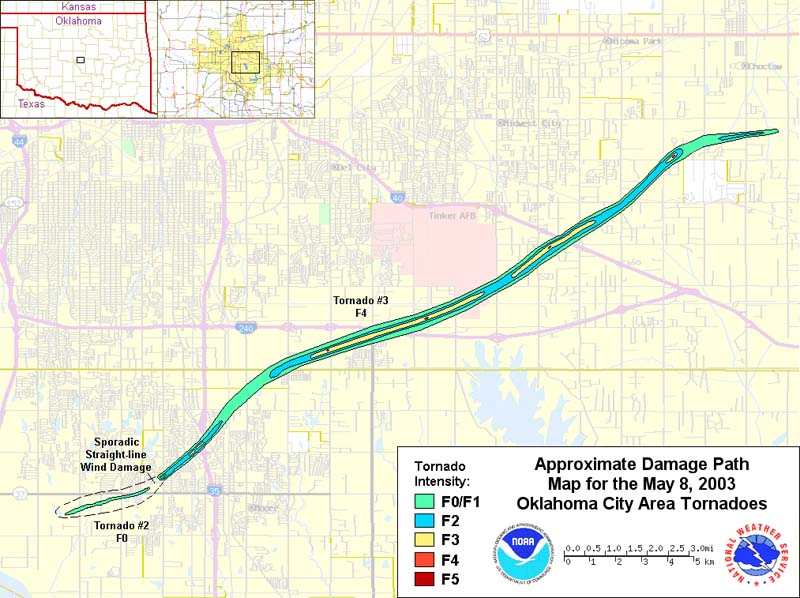
| 05/08/2003 | 1610-1638 | 17 | 700 | F4 | 0 | 134 | Cleveland/ Oklahoma | Moore - Oklahoma City (SE) - Midwest City (SE) - Choctaw [~1/2 mile N of SW 134th and Santa Fe to 1/2 mile ESE of Reno and Choctaw] (1.5 W Moore - 2.5 SSE Choctaw) | |
|
This violent tornado formed rapidly at 4:10 pm CST (5:10 pm CDT) near Santa Fe Avenue and NW 5th Street in Moore, OK and quickly strengthened to F3 intensity as it moved east-northeast through Moore. During this phase it paralleled the path of the May 3, 1999 F5 tornado, but tracked 1/4 mile or less farther south. The most intense damage in Moore (F3) occurred just west of U.S. Interstate Highway I-35 and north of 12th Street, where several businesses were leveled. The tornado then moved northeast and weakened to F2 intensity as it crossed into Oklahoma County just west of Bryant Avenue. In this area, the damage track coincided exactly with that of the May 3, 1999 tornado. This tornado then turned more to the east-northeast, crossing U.S. Interstate Highway I-240 near Sooner Road and causing F3 and sporadic F4 damage along U.S. Interstate Highway I-240 from near Sunnylane Road east to Air Depot Boulevard. The tornado struck the General Motors assembly plant near U.S. Interstate Highway I-240 and Air Depot Boulevard, inflicting F4 damage, then crossed the southeastern part of Tinker Air Force Base. Continuing northeast, the tornado inflicted F3 and sporadic F4 damage mostly to residential and rural areas in far southeast OKC and south and east sides of Choctaw, before turning more to the east and ending at 4:38 pm CST just southwest of Reno Avenue and Indian Meridian Road. Damage was estimated in $370 million. |
|||||||||
| 05/10/2010 | 1620-1651 | 24 | 2000 | EF4 | 2 | 49 | Cleveland/ Oklahoma | Far north Norman (near Santa Fe/Indian Hill Road) - south Moore - Lake Draper - I-40/Choctaw - 1.5 SSE Harrah | |
|
This long-tracked and devastating tornado developed west of U.S. Interstate Highway 35, northwest of Max Westheimer Airport. Widespread tree, power line/pole damage was reported from near I-35 to the east side of Stanley Draper Lake. Several homes also sustained damage, mainly with mostly roofs receiving significant damage, and some siding was ripped off. Several fences were also knocked down as the tornado moved northeast. From the east side of Lake Stanley Draper, near Hiwassee Road and SE 89th Street, to just south of Harrah, the damage path became more severe and focused. The tree damage became more severe, breaking at various heights of the tree or being uprooted. Walls of homes collapsed, and debris from the homes scattered in all directions. Several 2x4's punctured roofs and ceilings over numerous structures. A few mobile homes in this area were also completely destroyed. Where the tornado crossed U.S. Interstate Highway 40, a gas station and drive-in restaurant sustained up to EF-3 damage. The most severe damage, one of the two EF-4 tornadoes of the day, occurred in the Deerfield West Subdivision. A well-built residence here was completely destroyed, with most exterior and interior walls collapsing. The tornado finally lifted 2 miles south of Harrah. In addition to the incredible damage, one person lost their life while trying to flee the tornado. |
|||||||||
| 05/10/2010 | 1632-1659 | 22 | 880 | EF4 | 1 | 32 | Cleveland/ Pottawatomie | South Norman (0.5 E National Weather Center) - Lake Thunderbird - Little Axe - 4 E Pink | |
|
This violent tornado touched down a few hundred yards south of the National Weather Center in Norman, Oklahoma. The damage intensity increased gradually along the path with significant damage beginning as the tornado approached Lake Thunderbird. This tornado crossed Lake Thunderbird, severely damaging two campgrounds and the marina where about 300 boats were docked. The most severe damage occurred from the Little Axe School to the Cleveland/Pottawatomie county line. Trees were stripped of some bark and branches. Large objects were thrown considerable distances, including some concrete pillars. The metal bleachers near the school were tossed or rolled several hundred yards. Some appliances were also lofted as a dryer was found about 50 feet up in a tree. Considerable structural damage also occurred, as some foundation homes were mostly destroyed. In addition to the damage, one person lost their life as a result of the tornado. |
|||||||||
| 05/10/2010 | 1639-1659 | 17 | 440 | EF2 | 0 | 3 | Cleveland/ Pottawatomie | 7 ESE Noble - Norman (east) - 4 E Pink | |
|
This tornado developed west of SE 120th Avenue between Maguire Road and Cemetery Road. The tornado moved through a mobile home park northeast of SE 120th Avenue and Maguire Road causing significant damage to a number of the mobile homes and injuring 2 people. The tornado continued to cause tree damage as it moved northeast, then heavily damaged the Country Boy IGA grocery store and service station on OK State Highway 9 to the east of Lake Thunderbird. The tornado began to move east-northeast and moved into Pottawatomie County along OK State Highway 9 about one minute before tornado #J1 also crossed into Pottawatomie County at about the same location. The tornado moved into Pottawatomie County from Cleveland County and was generally about one mile northeast of tornado #J1 in Pottawatomie County. This tornado continued north of State Highway 9 causing tree and roof damage on the west side of State Highway 102 before dissipating. |
|||||||||
| 05/24/2011 | 1606-1701 | 33 | 880 | EF4 | 1 | 48 | Grady/ McClain/ Cleveland | 2 S Chickasha - Oklahoma City (near SW 149th/Portland) | |
|
This tornado formed on the south side of Chickasha in Grady County, quickly doing EF-2 damage. Mobile homes were damaged and destroyed, trees were uprooted or destroyed, outbuildings were destroyed, and many buildings lost significant portions of their roofs. One fatality occurred as a mobile home was destroyed in the south portion of Chickasha. As the tornado moved northeast of Chickasha, it gained significant strength, with several areas receiving EF-4 damage. Well-built homes were destroyed. Trees were debarked with only stumps remaining. Cars were thrown hundreds of feet. Almost continuous EF-3/occasional EF-4 damage occurred northeast until it crossed into McClain County, 1.5 miles south of OK State Highway 9. The tornado was probably at its strongest as it neared/crossed the Grady/McClain County line. Wind speeds there were estimated near 200 mph in this area. Significant damage continued as the violent tornado moved over the McClain County border. This may have been the strongest portion of this tornado, with wind speeds near 200 mph. Well-built homes were destroyed, with some cleaned off of their foundation. A concrete dome home was severely damage, mainly by the flying debris. Trees were debarked or destroyed. Very little was left standing for the first few miles into McClain County. Fairly consistent EF-3, with brief periods of EF-4 damage occurred as the tornado approached and then crossed OK State Highway 9, near the OK State Highway 76 junction. The tornado began to weaken as it moved toward the Cleveland County border, with mainly trees and power poles/lines snapped. The tornado continued into Cleveland County and where some minor tree/power pole/power line damage occurred. A few barns and outbuilding also sustained minor damage east of U.S. Interstate Highway I-44. The tornado dissipated just north of the Canadian River. The tornado traveled along a path length of 32 miles through three counties in just under an hour, Peak wind speeds were estimated just under 200 mph. |
|||||||||
| 05/19/2013 | 1700-1750 | 23 | 1500 | EF4 | 2 | 10 | Cleveland/ Pottawatomie | East Norman (8 E downtown) - 6.5 ESE McLoud | |
|
A long-track tornado began at 5:00 pm CST (6:00 pm CDT) in Cleveland County in east Norman to the north of Lake Thunderbird along 96th Avenue to the south of Tecumseh Road. The tornado moved northeast, crossing the eastern arm of Lake Thunderbird. A number of homes were significantly damaged as the tornado moved east-northeast through neighborhoods from near Indian Hills Road and 168th Avenue SE to the Pottawatomie County line. The large tornado moved east-northeast into Pottawatomie County at 5:20 pm CST then curving northeast as it approached State Highway 102. The tornado moved through a mobile home park north of Independence Road after crossing State Highway 102. Just northeast of the mobile home park, a permanent home was destroyed with much of the debris blown well to the northeast. It continued northeast crossing U.S. Interstate Highway 40 near the intersection of U.S. Highway 177, then curved north-northeast finally dissipating near Wolverine Road and Coker Road at 5:50 pm CST. One fatality occurred in the mobile home park, and another man was killed in his vehicle. |
|||||||||
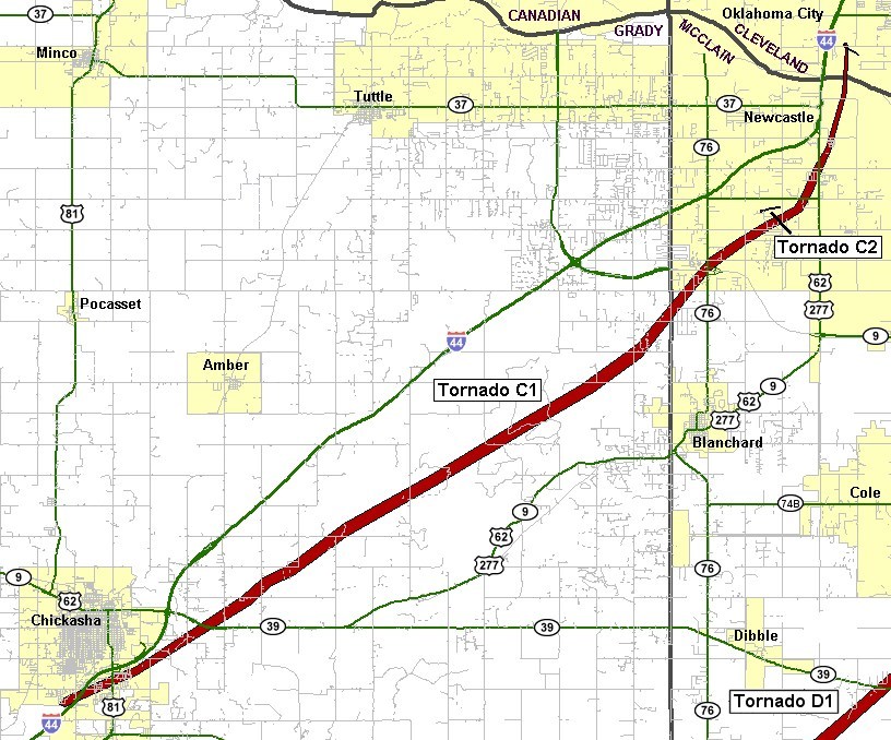
| 05/20/2013 | 1356-1435 | 14 | 1900 | EF5 | 24 | 212 | McClain/ Cleveland | Newcastle (3 NW US-277/SH-130) - 3 WNW Stanley Draper Lake Dam | |
|
The violent Newcastle-Moore tornado was first observed at 1:56 pm CST (2:56 pm CDT) developing about one-half mile south of Oklahoma State Highway 37 in northwest Newcastle to the east of Rockwell Avenue. EF4 damage was observed soon after the tornado crossed State Highway 37. The tornado continued to expand in size as it approached the Canadian River and moved into Cleveland County. The tornado then moved into Cleveland County at 2:04 pm CST from McClain County as it moved northeast across the Canadian River near U.S. Interstate Highway 44. The tornado then turned more east and then east-northeast after crossing I-44. Violent E-F4 damage was again observed as it began to move into progressively higher density residential areas approaching May Avenue. The center of the large tornado path passed near SW 149th Street and Western Avenue. After crossing Western Avenue, numerous buildings were destroyed and horses killed at Orr Family Farm. Two storage tanks estimated to weigh approximately 10 tons were lifted from Orr Family Farm and landed about one-half mile east. Moving east, the tornado destroyed much of Briarwood Elementary School, where the NWS storm survey team rated damage as EF-5. Despite the destruction of this elementary school during school hours, no fatalities occurred at the school. As the tornado continued to move east and east-northeast, it moved through much more densely populated suburban neighborhoods of southwest Oklahoma City and Moore where violent destruction was widespread. The width of EF-4 and greater damage was up to 250 yards wide as the tornado moved through neighborhoods east of Western Avenue. The first two fatalities occurred in a house in the neighborhood just east of Briarwood Elementary, with another fatality in a house as the tornado approached Santa Fe Avenue. After crossing Santa Fe Avenue, the tornado moved through more suburban neighborhoods and toward Plaza Towers Elementary School. Damage to the school was extensive and seven children were killed when a wall collapsed at the school. Nine other people were killed in eight different neighborhood homes within one-quarter mile of Plaza Towers Elementary, most occurring just south of the school. The tornado turned northeast as it approached Telephone Road, made a loop near the intersection of Telephone Road and 4th Street, then moved southeast crossing the interstate. Three people were killed when a convenience store along Telephone Road was destroyed. Crossing Telephone Road, the tornado inflicted significant damage to the Moore Medical Center, a post office and numerous businesses along Telephone Road and U.S. Interstate Highway 35. Although the tornado was narrower after crossing I-35, it continued to produce EF-4 damage in neighborhoods east of the interstate as it curved east and then again east-northeast. One fatality occurred at a business just east of the interstate, and one final fatality occurred in a home between Eastern Avenue and Bryant Avenue. Consistent EF-4 damage continued until the tornado passed SE 4th Street just east of Bryant Avenue. Moving east from Bryant Avenue, the tornado continued to produce EF-2 damage with isolated EF-4 damage noted. The density of housing also decreased east of Bryant as the tornado moved east and east-northeast before dissipating at 2:35 pm CST east of Air Depot Blvd. between SE 119th Street and SE 134th Street in southeast Oklahoma City. Overall, over 300 homes experienced EF-4/EF-5 damage along the tornado path. |
|||||||||
| 03/25/2015 | 1734-1750 | 11 | 50 | EF2 | 0 | 7 | Cleveland | 4.5 WNW - 7 SE Moore | |
|
A strong, upper-level storm system moved across the Southern Plains during the late afternoon and evening. At the surface, a slow-moving cold front and dryline served as foci for severe thunderstorm development. With strong instability and wind shear, very large hail and damaging winds were widespread. A couple of tornadoes also developed, with the most significant tornado moving through portions of the south Oklahoma City metro. The tornado began at 6:34 pm CST near Southwest 119th Street in southwest Oklahoma City, then moved east-southeastward. The tornado moved through Moore, then continued to its ending location just southeast of Indian Hills Road and 36th Avenue Northeast in far north Norman. The tornado had an eleven-mile, discontinuous path, with minor to moderate damage to homes and businesses. Seven people were injured, but no fatalities occurred. |
|||||||||
| 02/26/2023 | 2114-2138 | 27 | 900 | EF2 | 0 | 12 | McClain/ Cleveland | 2 NE Cole - Goldsby - Norman (south and east) - 2 NE Stella | |
|
A powerful storm system, with highly anomalous magnitudes of wind shear and moisture for late February, impacted the forecast area on the evening of the February 26, 2023. A broken line of severe thunderstorms developed across the eastern Texas Panhandle/far western Oklahoma and quickly swept through much of the forecast area. Widespread wind damage, including gusts near 90 mph, along with a record number of tornadoes (13) for February occurred. Several reports of large hail were also received. Behind the line of thunderstorms, a tight pressure gradient and strong westerly low-level jet allowed widespread 50-60 mph winds gusts to continue through the late evening hours. This tornado developed just west of Pennsylvania Avenue about 1/2 mile south of 290th Street where it took the roof off an outbuilding. The tornado moved east-northeast damaging a mobile home along 290th Street, and then snapped a couple of power poles as moved into the city limits of Goldsby just east of SW 24th Avenue. The tornado caused roof and fence damage in a neighborhood near NW 12th Avenue and Center Road in Goldsby before moving across the Goldsby airport damaging hangars. The tornado then crossed the Canadian River into Cleveland County. The tornado that moved through Goldsby in McClain County crossed the Canadian River and into Cleveland County moving swiftly through southern and eastern portions of Norman. The tornado passed less than one mile southeast of the National Weather Center, and damaged numerous homes in neighborhoods near 12th Avenue SE and Cedar Lane Road, and northeast of 24th Avenue SE and Imhoff Road as well as damaging apartments and businesses near the intersection of State Highway 9 and US Highway 77. EF2 damage was noted at several apartment buildings, homes and businesses in these areas. Moving northeast, the tornado moved into less areas with less density of homes and people, but still affected neighborhoods near 36th Avenue SE and Lindsay Street, 48th Avenue SE and Lindsey, and 60th Avenue SE and Alameda Street. The tornado continued northeast damaging trees, power lines and a few homes before dissipating in far southeast Oklahoma City near SE 125th Street and Dobbs Road. The tornado moved at over 60 mph. |
|||||||||
| 11/03/2024 | 0020-0025 | 2.4 | 400 | EF3 | 0 | 6 | Cleveland/ Oklahoma | 3 NE Moore - 3 ESE Valley Brook | |
Records taken from the Storm Prediction Center archive data, "Storm Data", and data from the National Weather Service office in Norman. Data modified as described in NOAA Tech Memo NWS SR-209 (Speheger, D., 2001: "Corrections to the Historic Tornado Database").
Historic data, especially before 1950, are likely incomplete.

